Tag Archives: windsor tornado

Windsor Tornado to be featured on the Weather Channel

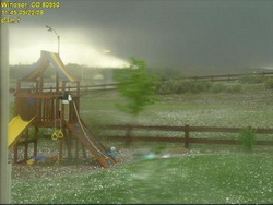
The Weather Channel's new season of Storm Stories will feature the Windsor Tornado from May 2008.  This scary image was taken by the webcam of MyWindsorWeather.com as the twister tore through the town on May 22, 2008.
The Weather Channel's new season of Storm Stories will feature the Windsor Tornado from May 2008. This scary image was taken by the webcam of MyWindsorWeather.com as the twister tore through the town on May 22, 2008.

This Sunday, February 22nd at 6:00pm MST, the Weather Channel will premiere the new season of its series Storm Stories.  Most notably, the first episode will highlight a weather event from last year that struck very close to home – the May 22nd Windsor Tornado

For those that haven’t seen Storm Stories, it is an exciting, sometimes scary and sad series discussing significant weather events as seen through the eyes of those that experienced it firsthand.  For the Sunday episode, renowned storm tracker Jim Cantore from the Weather Channel will tell the story of the twister using footage from a variety of sources, including the video most have seen from KUSA (see below).  

Area residents were interviewed for what is sure to be an extraordinary episode and will serve as a poignant reminder that we in the Denver area live at the edge of tornado alley. Click here to view a story about the filming of the episode on the Windsor Beacon’s website.

The kickoff of the new season of Storm Stories is actually the beginning as well of the Weather Channel’s ‘Tornado Week’ in which twisters are front and center.  Other episodes of note during the week:

  • Monday – the “Parkersburg, IA, Tornado” on May 25, 2008, killed seven people and demolished the southern half of the town; first-hand accounts are given by residents.
  • Tuesday – the “Greensburg, KS, Tornado” on May 5, 2008, wiped out the entire town.  The story is told through the experiences of next-door neighbors who saved a mother and her baby from the rubble.
  • Wednesday – “Super Tuesday” tornadoes cut a swath over a wide area Feb. 5, 2008; touching stories come from people that were affected in Arkansas, Kentucky and Tennessee.
  • Thursday – the “Boy Scouts Tornado” hit the Little Sioux Scout Ranch in western Iowa last June, catching everyone off guard.  The surviving scouts are forced to put their training to use in the midst of a terrifying situation to help keep injured scouts alive in the aftermath.

Be sure to check the Weather Channel’s website as there are a lot of other interesting shows related to tornadoes throughout the week.  Click here to view a press release with the full announcement

Thank you to Ryan of MyWindsorWeather.com for bringing this story to our attention.

Top weather story of 2008 – The Windsor tornado

This amazing image of the Windsor tornado was taken from a backyard webcam. Image courtesy MyWindsorWeather.com.

May 22, 2008 started like most other spring days in Colorado.  That Thursday morning had dawned with relatively mild temperatures and a touch of humidity in the air.  That moisture in the air was a warning sign as moist air from the Gulf of Mexico was entering the state and a signal of the potential for severe storms.  No one knew though just what was in store for a small town in northeastern Colorado.

As temperatures rose in the morning, the moist air near the ground mixed with fast moving dry air aloft and created conditions ideal for supercell thunderstorms and tornadoes.  Hail began to fall around 11:20am near Platteville, a harbinger of things to come.  As the weather situation became much more excited and confused, reports of a twister on the ground near Gilcrest at 11:29 rolled in.

A classic wedge tornado had formed and was moving to the north-northwest at a leisurely 30 mph wreaking havoc and destruction all along its path.  Examiner.com soon posted a special report at 11:30 warning of the twister and showing its expected path.  It narrowly missed the town of Milliken, dumping baseball sized hail on it instead.  The twister was now a full mile wide with winds in excess of 136 mph and at 11:57am, the storm struck Windsor, home to 16,000 Coloradoans.  By the time it was done with the town, it had claimed one life, destroyed 80 homes and damaged nearly 770 others.

For a total of nearly 45 minutes the storm carved a 35 mile long path of devastation and all along its path it left the evidence – houses with nothing but a foundation left, power poles snapped like matchsticks, semi-trailers overturned like toy cars, mangled pieces of metal and shards of wood.

Tornadoes in Colorado are not uncommon with an average of 60 per year, although most do occur on the eastern plains in more rural areas.  The storm was only the second deadly tornado in Colorado in the last 10 years (the Holly tornado in 2007 being the other) but it served to highlight that the Front Range is on the western edge of Tornado Alley.  Weld County is in fact Colorado’s own tornado capital having had more twisters than any other county since 1950.

When it was over, Coloradoans showed their sense of community in helping the affected areas.  The Red Cross immediately went into action as did the state government in calling out the National Guard to help.  Donations poured in and other relief agencies provided food and shelter to those left homeless.  While the Windsor Tornado was an example of the worst of Mother Nature, the storm also showed us the best of mankind.  No other weather event comes close to being Colorado’s biggest weather story of 2008.

Below is some amazing raw video from 9News of the tornado as it moved north.

Wild Western Weather 2008 announced

Wild Western Weather 2008 will be held on November 18th.

The channel 7 24 / 7 Weather Center has accounced an exciting event – Wild Western Weather 2008.  The event will be held at the Wild Life Experience in Parker on Tuesday, November 18th from 6:00pm to 10:00pm.  This looks to be a great event with a number of notable speakers.  

Some of the highlights include: 

  • Tim Samaras – Tornado Expert – featured in National Geographic Magazine, “Inside Tornadoes – The Latest Research: Twistex 2008” 
  • Tony Laubach – Storm Chaser – “The Windsor Tornado vs Douglas County Landspouts” 
  • Dr. Walt Lyons – Lightning Researcher – “Flash Facts – Red Sprites, Blue Jets and Other Rare Airities” 
  • Ethan Green – Director, Colorado Avalanche Information Center – “Avalanches and the Big Snow Winter of 2007-08” 
  • Dr. Thomas Schlatter – NOAA’s Earth System Research Lab and the University of Colorado – “The Pine Bark Beetle – A Canary for Climate Change?”
  • I do wish they had chosen a more central location for it or at least held the event on the weekend.  It is pretty tough for anyone who works and lives north to try to make it down there. 

    For more information, check it out on channel 7’s website here:  http://www.thedenverchannel.com/weather/5103957/detail.html

    Windsor Tornado Officially Rated as EF3

    The National Weather Service has completed their tornado assessment of the Windsor tornado and determined the twister was rated an EF3 on the Enhanced Fujita scale.  See below for details and here for a map of the path the twister took

    PUBLIC INFORMATION STATEMENT…UPDATED…
    NATIONAL WEATHER SERVICE DENVER CO
    430 PM MDT FRI JUN 6 2008

    ..WELD COUNTY TORNADO OF MAY 22 2008 RATED AN EF3 TORNADO…

    On Thursday May 22 2008 a wide and powerful tornado swept north northwestward for 34 miles from northeast of platteville in Weld County at 1126 AM MDT to 7 miles east northeast of Fort Collins in Larimer County at 1216pm MDT.   The National Weather Service tornado damage assessments conducted on Friday May 23rd and Saturday May 24th documented large areas of damage.  On the enhanced Fujita scale there were pockets of EF3 damage especially near the Missile Silo Park Campground west of Greeley and to homes and businesses in eastern Windsor.  Wind estimates in the heavily damaged areas were as high as 130 to 150 mph. 

    The tornado was as wide as one mile at times along its path.  There was one fatality and 15 to 20 injuries.   Damage estimates are not finalized, but preliminary numbers from FEMA are 850 homes damage, with nearly 300 homes signficantly damged or destroyed.  Privately insured damages total 174 million dollars…and the Poudre Valley Rural Electric Association reported one million dollars of damage to electric transmission facilities.  

    One question frequently asked is how unusual was this event.  Certainly it was not unusual in time of year (May and June are the peak tornado months in Colorado).  It was not unusual in location (more tornadoes are reported in Weld County than any other county).  It was slightly earlier in the day than normal, as we usually see tornadoes in the mid afternoon to early evening.  The track was longer than most, the tornado was moving fastern than most,  and a track moving north northwest is very unsusual.  Since 1950 there have been a total of 20 tornadoes of f3 and higher within Colorado.  This was the second f3 tornado reported in weld county since 1950.   On May 15, 1952 an F3 tornado injured 5 people within the county. 

    For reference…the Enhanced Fujita Scale classifies tornadoes into the following categories:

    EF0…wind speeds 65 to 85 MPH.

    EF1…wind speeds 86 to 110 mph.  

    EF2…wind speeds 111 to 135 mph.

    EF3…wind speeds 136 to 165 mph. 

    EF4…wind speeds 166 to 200 mph. 

    EF5…wind speeds greater than 200 mph.