As the sun went down yesterday a thunderstorm moved over the Thornton area. It provided some brief, heavy rain which was very welcome given our drought stricken landscape. Accompanying the moisture was a good bit of lightning which lit up the post-sunset sky.
Our west facing webcam captured one bolt as it struck turning night into day for a brief instant.
A thunderstorm on June 23, 2013 delivered rain and a good bit of lightning. ThorntonWeather.com’s west facing camera happened to capture one bolt as it struck.
Satellites provide an amazing eye in the sky for monitoring the weather and climate. Their usefulness today was once again proven as they captures wildfires exploding in Colorado’s southwest and thunderstorms to the northeast.
The satellite imagery animation comes from the NOAA GOES East satellite and was assembled by Colorado State University RAMSDIS. It covers the period from 1:55pm to 4:40pm on Friday, June 21, 2013.
The tandem West Form Fire and Papoose Fire in southwestern Colorado are seen sending massive smoke plumes into the sky. Afternoon thunderstorms are exploding in the northeastern corner of the state.
Wildfires are a very real danger here in Colorado.
As wildfires burn across much on the western United States late this summer, the Internet can be a wealth of information for residents that are affected by these blazes or for anyone else. Resources are available for everything from the latest news updates, finding out where the fires are right down to the street level, to safety and education.
This list is by no means all inclusive – if you have a wildfire related link we are missing, please post a comment and let us know and we will update our list!
The tornado near DIA sent workers working on the terminal renovations scrambling. (Rob Gardner)
The tornado that struck on the grounds of Denver International Airport (DIA) on Tuesday, June 18, 2013 has been rated an EF1 with winds up to 109 mph. The twister came within a half mile of Concourses A and B and sent workers and travelers scrambling to tornado shelters.
Scroll down to see more photos of the tornado.
From the National Weather Service:
A tornado developed on Denver International Airport (DIA) grounds on the afternoon of June 18, 2013. The tornado formed around 2:19 PM just north of 70th Avenue. The tornado then moved slowly northwest between Runway 35R and 35L, and moved to within a half mile of Concourses A and B before dissipating at 2:36 PM. The tornado moved extremely close if not over the ASOS (Automated Surface Observation System) and another low level wind shear sensor at DIA. The ASOS weather observing system reported a 97 mph wind gust at 2:27 PM, while the wind shear sensor reported a wind gust to 109 mph at the same time – indicative of an EF1 tornado. There was only minor damage noted to this equipment. The storm responsible for this tornado first developed just south of the airport, and then drift slowly northward across the eastern side of DIA. At 2:05 PM, there was weak rotation beginning to develop underneath this storm as noted by the velocity data below. This rotation then strengthened quickly between 2:10 and 2:22 PM.
Under the influence of strong high pressure, the mercury soared in the Mile High City on Monday and two temperature records fell.
As measured at Denver International Airport, the mercury reached a high of 99 degrees at 2:53 p.m. This broke the previous record high temperature for June 10 of 97 degrees set in 1952.
Here in Thornton we were hot but not quite as hot. Our high temperature topped out at 97 degrees at 2:35 p.m. This is the highest temperature we have seen thus far this year and the highest reading in Thornton since July 21, 2012 (97.9 degrees).
If you thought the nighttime would bring relief from the heat, you were mistaken. Denver’s official “low” temperature on Monday was only 68 degrees. This set a new record high minimum for the date easily besting the previous record holder of 64 degrees last set in 1990. Thornton was just slightly cooler with a low for the date of 66.8 degrees.
There won’t be much of a break in the heat in the coming days. While it will be cooler than today, temperatures for the rest of the week are expected to continue to be well above normal. Get the latest forecast here.
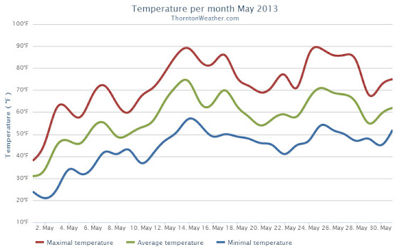
Following on colder and wetter than normal weather in previous months, Thornton’s May returned us to drier and warmer than normal conditions.
The month started out with a bit of a wintry blast of cold temperatures and snow. In fact, Denver even set an all-time May low temperature on the 2nd of the month.
The cold and snow that started the month were probably overall the most notable feature of the month. The rest of May was not particularly extraordinary in any aspect.
Denver’s average temperature for the month was 57.9 degrees. This was 0.8 degrees above average. Here in Thornton we were just slightly cooler with an average temperature of 57.6 degrees.
Thornton’s temperatures ranged from a high of 89.2 degrees on the 14th down to a low of 20.7 degrees on the morning of the 2nd. Denver saw a maximum temperature of 88 and a low of 19 degrees.
Official Denver temperature records for the month included:
DAILY RECORDS:
DATE TEMPERATURE TYPE OF RECORD OLD RECORD YEAR LAST SET
MAY 2ND 19 DEGREES RECORD LOW 22 DEGREES 1954
MAY 14TH 87 DEGREES TIED RECORD HIGH 87 DEGREES 1996
MONTHLY RECORDS:
DATE TEMPERATURE TYPE OF RECORD OLD RECORD YEAR LAST SET
MAY 2ND 19 DEGREES TIED RECORD LOW 19 DEGREES MAY 3RD 1907
In terms of precipitation, Denver recorded only 0.82 inches, far below the average for May of 2.12 inches. Here in Thornton Mother Nature was far more generous as we recorded 2.35 inches.
The snow that started the month totaled 4.3 inches in Thornton, 3.4 inches in Denver. Both were well above the May average of 1.1 inches snowfall.
One of our favorite pastimes is simply watching the clouds. Colorado’s widely varying weather provides a stunning variety in almost every season. One photographer captured an amazing time lapse video of what he called “Bubbly Rocky Mountain Clouds.”
May 19 to May 25: This Week in Denver Weather History
Severe weather takes to the forefront in our look back at this week in Denver weather history. We see many historical flooding events that were commonplace in the late 19th / early 20th century before controls were put in place. Almost everyone will recall the Windsor tornado, an EF3 monster that struck the town five years ago.
From the National Weather Service:
18-19
In 2011…a severe thunderstorm in central Adams County produced large hail and heavy rainfall on the 18th. Large hail from 1 inch to 1 3/4 inches in diameter…was reported in Commerce City…2 miles south-southeast of federal heights…Northglenn…and 2 miles south of Thornton.
In Commerce City…the storm uprooted trees and knocked out power lines. A carport was lifted off the ground and struck the power lines overhead. Heavy rain…from 1.0 to 1.5 inches fell in less than 2 hours in Commerce City and near Brighton. The combination of hail and strong winds broke windows in Northglenn.
In the foothills…moderate to heavy snow showers developed overnight. Storm totals included: 10.5 inches at Gold Hill…9.5 inches…3 miles west of Jamestown; 9 inches at Lake Eldora; with 6 inches… 11 miles southwest of Gilpin and 4 miles east-northeast of Nederland. At Denver International Airport…total rainfall over the 2-day period totaled 1.71 inches.
In addition…a peak wind gust to 37 mph was recorded on the 18th.
18-20
In 1915…3.9 inches of snow fell in the city. The estimated amount of snow that melted as it fell was 6.2 inches which would have totaled an estimated 10.1 inches of snowfall. Precipitation totaled 1.03 inches. North winds were sustained to 32 mph on the 18th. Low temperatures dipped to 25 degrees on both the 18th and 20th…establishing record minimums for both dates.
In 1988…prolonged heavy rainfall drenched metro Denver. The event began when heavy thunderstorms on the 18th caused some street flooding and power outages…followed by steady rain on the 19th and 20th. Rain amounts across metro Denver totaled 3 to 4 inches. Rainfall totaled 3.71 inches at Stapleton International Airport where north winds gusted to 39 mph on the 20th. Four to eight inches of snow fell in the foothills above 7 thousand feet.
19
In 1927…southeast winds were sustained to 40 mph with gusts to 44 mph.
In 1956…a thunderstorm wind gust to 54 mph was recorded at Stapleton International Airport.
In 1969…hail stones to 1 inch in diameter were measured in Arvada and Aurora. Some minor damage was reported. Pea to marble size hail fell in Westminster.
In 1972…a tornado was reported by aircraft about 5 to 10 miles east of Parker.
In 1988…lightning started a fire at a house in the Denver suburb of greenwood village…causing 2 thousand dollars in damage.
In 1991…strong thunderstorms over east metro Denver produced wind gusts of 56 to 60 mph. The strong winds downed power lines…trees…and fences at some locations in Aurora. Thunderstorm outflow winds gusted to 60 mph at Stapleton International Airport.
In 1994…severe thunderstorms rumbled across metro Denver. The storms produced wind gusts averaging 65 mph and hail up to dime size. Wind gusts to 77 mph were recorded in Brighton. Numerous trees and power poles were downed by the winds. One power pole fell onto spectators at a high school graduation ceremony in Commerce City…injuring 6 people. In Fort Lupton…trees fell onto 2 parked cars… Knocking out the windshields. Hail to 3/4 inch in diameter was reported in Littleton. A thunderstorm wind gust to 52 mph was recorded at Stapleton International Airport.
In 1995…a slow moving tornado…which was mainly discernible by its dust and debris cloud…was spotted 2 miles northeast of Denver International Airport or about 10 miles northwest of Bennett. No damage was reported.
In 2007…lightning struck a 33-ft statue of Jesus at Mother Cabrini Shrine…in the foothills west of Golden. The blast broke off one of the statue’s arms and a hand…and also damaged a foot. It cost an estimated $200000 to repair.
In 2009…lightning struck the roof of a residence in Highlands Ranch. The home was not a total loss…but the fire caused extensive damage.
In 2010…a thunderstorm produced hail up to 7/8 inch in diameter in Thornton.
19-20
In 1864…a devastating major flash flood occurred on the normally dry and sandy Cherry Creek in Denver. The flood was caused by heavy thunderstorm rainfall and hail over the palmer ridge to the south of the city in both the Cherry Creek and plum creek basins. Nineteen deaths occurred along the South Platte River and Cherry Creek in Denver. The torrent swept cattle and sheep along with large trees and houses before it washing out several bridges…and moving large structures from their foundations. All city records were destroyed when city hall washed away. The rocky mountain news building…built on stilts in the middle of the creek…was totally destroyed by the raging waters…which were as deep as 5 feet on the morning of the 20th. Once the flood waters receded…much sand and gravel was left behind. Property damage from the flood was estimated at nearly one million dollars. This was the first major flood of record in the city.
The unseasonably warm weather this week reached record setting levels today. At 1:55pm the temperature at Denver International Airport reached 87° tying the record high temperature for the date previously set on May 14, 1996.
Here in Thornton we were a couple of degrees warmer as the mercury climbed to 89°. This is the warmest temperature we have recorded since September 10 of last year (91°).
Don’t miss a thing when it comes to our ever changing weather! Be sure to ‘like’ us on Facebook, follow us on Twitter and add us to your Google+ circles.
May 12 to May 18: This Week in Denver Weather History
The snow is gone – almost – but as our look back at this week in Denver weather history shows, it could return. That however is unlikely and more typical spring severe weather is far more common.
From the National Weather Service:
10-12
In 2011…a spring snowstorm brought heavy snow to the Front Range foothills and Palmer Divide. Storm totals included: 18 inches…4 miles south-southeast of Pinecliffe; 16 inches in Coal Creek Canyon; 15 inches…4 miles west-southwest of Eldorado Springs; 13 inches at Gold Hill…12 inches…4 miles west-southwest of Conifer and 4 miles northwest of Elizabeth; 11.5 inches…6 miles southwest of Evergreen and 4 miles east-northeast of Nederland; 11 inches…3 miles east of Jamestown and 10.5 inches…3 miles east of Franktown and 3 miles south of Golden and 10 inches…10 miles north of Elizabeth. At Denver International Airport… 1 inch of snowfall was observed.
12
In 1875…two forest fires on the eastern slope of the foothills were visible from the city.
In 1904…north winds were sustained to 40 mph with gusts to 48 mph.
In 1950…brilliant and complete primary and secondary rainbows arching across the sky were observed from Stapleton Airport.
In 1951…a wind gust to 51 mph was recorded at Stapleton Airport.
In 1984…winds gusted to 69 mph in Boulder. Northwest winds gusted to 47 mph at Stapleton International Airport.
In 1987…a small weak tornado touched down for about 2 minutes in southeast Denver. The twister hit a car dealership…blowing about a dozen windows out of cars and shattering four skylights on the building. Some tin roofing was blown off a patio a block and a half away. The tornado also downed a power pole. Damage at the dealership was estimated at 10 thousand dollars. A man was slightly injured by lightning in northwest Aurora.
In 1995…several funnel clouds were sighted near Parker. One of the funnels produced a short-lived debris cloud on the ground in an open field. No damage was reported.
12-13
In 1907…the temperature warmed to a high of 73 degrees on the 12th…before a cold front produced a thunderstorm… Northeast winds sustained to 40 mph…and rain changing to light snow overnight. Snowfall totaled only 2 inches…but the high temperature on the 13th was only 39 degrees.
In 1961…a storm that covered metro Denver with rain and snow started as thunderstorms on the evening of the 12th. Hail to 1 1/2 inches in diameter was reported 10 miles northwest of Stapleton Airport. Rain continued overnight and changed to snow on the 13th. Snowfall totaled 6.4 inches and precipitation (rain and melted snow) 1.96 inches at Stapleton Airport where north winds gusted to 39 mph. The rain and heavy wet snow caused icing damage to utility lines. Heavy snow occurred in the foothills.
In 1982…a major storm dumped 1.50 to 3.50 inches of rain across northeast Colorado and deposited prodigious amounts of snow in the foothills. Coal Creek Canyon southwest of Boulder was buried under 46 inches of snow with 39 inches at Nederland. The heavy wet snow downed many power lines in the foothills. In Thornton…the roof of a school was damaged by water from the heavy rain. At Stapleton International Airport…1.49 inches of rain were measured over the two day period. The heavy rain ended a severe and prolonged drought.
In 2004…a winter storm produced heavy snow in excess of a foot in the foothills above 6 thousand feet while heavy rain fell across the city. The heaviest snow occurred in the high country of Boulder County. Storm total snowfall was 14.5 inches near Jamestown. Rainfall totaled 0.81 inch at Denver International Airport with 0.94 inch recorded at Denver Stapleton. A trace of snow was recorded at both locations. East winds gusted to 24 mph at Denver International Airport on the 12th.
13
In 1905…a thunderstorm produced hail during the late afternoon. Precipitation totaled 0.57 inch.
13-14
In 1912…heavy snowfall totaled 12.4 inches over the city. Most of the snow…9.9 inches…fell on the 13th…which was the greatest 24 hour snowfall in May at the time. This was the last snowfall of the season. The low temperature dipped to 27 degrees on the morning of the 14th.
In 1989…a spring storm brought heavy rain and snow to the foothills. Metro Denver was soaked with 1 to 2 inches of rain. Rainfall totaled 1.26 inches at Stapleton International Airport.
In the foothills…Echo Lake received 20 inches of snow. A 30-ton Boulder slid onto I-70 east of the Eisenhower Tunnel…closing the freeway for 2 hours.


 Under the influence of strong high pressure, the mercury soared in the Mile High City on Monday and two temperature records fell.