April marks a transition between winter and summer for most of the country but for Denver it is especially true as we can see a stunning variety of weather.
The proverbial April showers are certainly a possibility for Denver. Snow? Tornadoes? Thunderstorms? You bet – all can happen!
For good measure throw in a chance for hail and even dust storms and April gives every type of weather condition you could like – or hate.
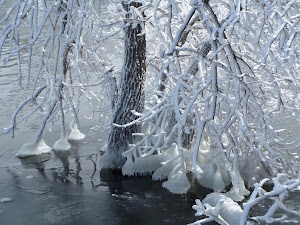
Wintry weather started the month of March in northeastern Colorado. View more images from the month in the slideshow below. (Marla Winter)
March along the Colorado Front Range can be a very pleasant time as temperatures climb with the approach to and arrival of spring. However the month is also Denver’s snowiest and wintry weather is not unusual. This variety of conditions will be reflected in our March 2014 slideshow below.
Slideshow updated March 31, 2014
Showcasing images captured by ThorntonWeather.com readers as well as some of our own, our monthly slideshow covers the entire gamut of weather-related imagery. Sunsets, sunrises, wildlife and of course snow are vividly depicted.
Throughout the month we will gather the images sent to us via email or shared with us via our various social media outlets and post them in the slideshow below.
As many as two dozen people were killed on Saturday, March 22, 2014 when a massive landslide swept down a rain-soaked hill near Oso, Washington. NASA satellite imagery taken before and after the event shows the extent of the event.
Using the ‘sliders’ on the image below you can compare how the area looks normally (left) versus how it looked after the landslide (right).
[wpw_ba_viewer width=”600″ height=”auto” anim_speed=”600″ start_percent=”0.5″ disable_intro=”false”]
[wpw_ba_img src=”http://lh6.googleusercontent.com/-I2mSOZBkFnQ/UzMQFKXi74I/AAAAAAAAB0s/tcA9N10o6cY/s600/wa-before.jpg” data_second=”http://lh5.googleusercontent.com/-VXmVfoDsFqQ/UzMQFPSNLNI/AAAAAAAAB0w/kIX2gla6sTA/s600/wa-after.jpg” title=”Satellite imagery comparison of the area near Oso, Washington before and after the March 22, 2014 landslide. (NASA EO)” data_info=”Satellite imagery comparison of the area near Oso, Washington before and after the March 22, 2014 landslide. (NASA EO)”]
[/wpw_ba_viewer]
From NASA:
On March 22, 2014, a rainfall-triggered landslide near Oso, Washington sent muddy debris spilling across the North Fork of the Stillaguamish River. The debris engulfed numerous homes, resulting in the deaths of at least 14 people. As of March 25, authorities reported that 176 people were still missing.
The slide left an earthen dam that blocked the river, causing a barrier lake to form. The Operational Land Imager (OLI) on Landsat 8 acquired this image of landslide debris and the barrier lake on March 23, 2014. An image of the same area acquired on January 18, 2014, is shown for comparison.
As water backed up, it raised fears of a potential flash flood. On March 23, water began to flow around the north side of the dam. However, as of the afternoon of March 25, a flash flooding watch issued by the National Weather Service remained in effect for parts of Snohomish county.
According to Durham University geologist Dave Petley, the landslide was a reactivation of an earlier landslide that caused problems in 1988 and 2006.
I have always been a shutterbug ever since my parents gave me my first SLR one Christmas when I was in high school. It wasn’t until recent years however that I began to hone the craft and now I have launched Tony’s Takes Photography.
Certainly I have no illusion of becoming a professional photographer or having the skills of one. This is purely a hobby for me. However I think I do a pretty passable job and decided I would like to share my images. Up until now that has been confined to this website and on social media with friends and family.
Over at Tony’s Takes (www.tonystakes.com) I will be sharing the images I capture. These will usually be focused on the subjects which interest me most – extreme weather, landscapes and wildlife. Certainly some of these photos will make their way here as always but that will be the primary spot where I post them.
Don’t worry though. Weather is still a passion of mine andThorntonWeather.com will be staying around as always and remaining your one and only spot for truly local Thornton weather news and information!
You can find Tony’s Takes Photography at any of the links below and I would truly appreciate you spreading on the work:
We headed out this morning looking for bald eagles at Cherry Creek State Park. Certainly saw LOTS of them but also enjoyed a beautiful morning with the snow-covered trees and blue skies.
The United States begins Daylight Savings Time at 2:00am on Sunday, March 10, 2013.
The biannual ritual of changing our clocks to adjust for Daylight Savings Time occurs this Saturday night providing yet another signal of the changing of seasons.
The United States will ‘spring forward’ one hour at 2:00am Sunday morning, March 9, as we begin Daylight Savings Time.
The ritual of changing our clocks twice a year can be met with some resistance as some people struggle to adjust their body’s internal clock. The start of Daylight Savings Time can be particularly problematic given the one hour less sleep people receive on the night of the change.
However, longer days as we head into the milder months are a very real benefit and for many worth the inconvenience of a lost hour of sleep. The time change definitely has big effects on how much daylight we enjoy during our normal waking hours.
On Saturday, prior to the change, sunset will occur at 6:00pm but on Sunday the sun won’t disappear over the horizon until 7:01pm. This affords folks more time in the evening to get started on those spring-time chores and allows us to get outside and enjoy the warming weather.
The spring equinox is also on the horizon. Spring officially begins at 10:57am on March 20.
This year Daylight Savings Time will come to an end on November 2.
Some of the recent history of Daylight Savings Time (from Wikipedia):
Daylight saving time in the United States was first observed in 1918. Most areas of the United States currently observe daylight saving time, with the exceptions being the states of Arizona and Hawaii along with the territories of Puerto Rico, American Samoa, Guam, and the Northern Mariana Islands.
From 1987 to 2006, daylight saving time in the United States began on the first Sunday of April and ended on the last Sunday of October. The time was adjusted at 2:00 AM (0200) local time (as it still is done now).
Since 2007, daylight saving time starts on the second Sunday of March and ends on the first Sunday of November, with all time changes taking place at 2:00 AM (0200) local time. In 2011, daylight saving time began on March 13 and will end on November 6.
Late winter in Colorado can bring a wide variety of conditions, oftentimes within a very short time span. This was fully evident yesterday and last night as we went from a high of a daytime 62 degrees to receiving a healthy dose of snow before midnight.
Thornton received a total of 2.9 inches of heavy, wet snow from about 9:00 p.m. on March 4 through 1:00 a.m. on March 5. A healthy 0.45 inches liquid precipitation was recorded from the snow.
The time lapse video below captures the event from its start through sunrise. Below that is a satellite imagery time lapse from 7:00 a.m. to noon to show just how fast that snow disappeared.
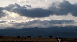
Screenshot of an amazing time lapse video showing mountain wave clouds. (YouTube / BasehuntersChasing)
Watching clouds in real time can be fascinating however it is when they are sped up via time lapse that we can oftentimes truly see the subtle motions that we otherwise miss. A time lapse video released by some local storm chasers provide a stunning visual of wave clouds near Boulder.
Posted to YouTube today by Basehunters Chasing, the video showcases scenes captured over a couple of days along the Front Range.
Rolling mountain wave clouds serve as a backdrop to cows in a field. Watching closely, snow can be seen falling on the highest mountain peaks. Zoomed in views of a wave cloud follow showing the amazing motion.
Lastly a sunset is seen with the clouds starting pastel orange, then turning brilliant bright orange before fading away.
The video is set to a very soothing flute-type instrumental. Check it out below.
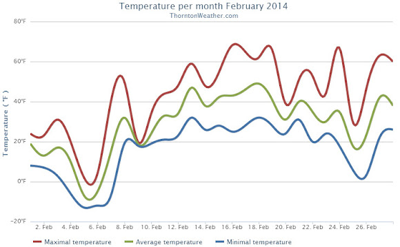
Like all months in Colorado, February 2014 did have some warm periods but those were few and far between as compared to the cold we experienced. Those cold temperatures did not translate to precipitation however.
The month started out quite cold with 9 out of the first 10 days seeing below normal temperatures. Two of those days saw ‘high’ temperatures only in the single digits. Seven of those 10 days stayed below freezing and four saw low temperatures below zero.
Warmer weather courtesy of downslope flow did finally arrive and most of the rest of the month was warmer than average. Of the last 18 days of the month, only two had below normal temperatures.
Overall Thornton’s monthly average temperature for February 2014 was 28.5 degrees. This was four degrees below Denver’s February average of 32.5 degrees. Officially Denver’s average for the month was close to ours at 28.2 degrees.
While clearly a cold month, February 2014 failed to reach ‘top 10 coldest February’ status. Number 10 on that list is February 1905 with an average temperature of 25.2 degrees. The coldest February was in 1899 with an average of 17.6 degrees.
Temperatures ranged from a high of 68.3 degrees on the 16th down to a low of -12.6 degrees on the morning of the 5th. Out at the airport, Denver saw its highest temperature of 68 degrees and its lowest of -19 degrees on the same dates.
Denver record low maximum temperatures on the 5th and 6th. High temperatures on those days were minus 1 degree and plus 1 degree respectively.
Thornton recorded a mere 0.17 inches of precipitation in the rain bucket during the month. Denver officially saw 0.19 inches. Both fall well short of the February average of 0.37 inches. While dry, it wasn’t dry enough to be one of the top 10 driest Februarys.
In terms of snowfall, Thornton measured 4.7 inches. Denver lagged with only 3.3 inches. Again, both were a good ways below the historical Denver average of 5.7 inches.
Thornton, Colorado February 2014 temperature summary. (ThorntonWeather.com)Add a Caption Thornton, Colorado February 2014 temperature summary. (ThorntonWeather.com)Thornton, Colorado February 2014 precipitation summary. (ThorntonWeather.com)
CLIMATE REPORT
NATIONAL WEATHER SERVICE BOULDER, CO
628 AM MST SAT MAR 1 2014

...................................

...THE DENVER CO CLIMATE SUMMARY FOR THE MONTH OF FEBRUARY 2014...

CLIMATE NORMAL PERIOD 1981 TO 2010
CLIMATE RECORD PERIOD 1872 TO 2014

WEATHER         OBSERVED          NORMAL  DEPART  LAST YEAR`S
                 VALUE   DATE(S)  VALUE   FROM    VALUE  DATE(S)
                                          NORMAL
................................................................
TEMPERATURE (F)
RECORD
 HIGH              77   02/28/2006
                        02/04/1890
 LOW              -25   02/01/1951
                        02/08/1936
HIGHEST            68   02/16        77      -9       63  02/17
LOWEST            -19   02/05       -25       6        5  02/22
AVG. MAXIMUM     42.3              46.2    -3.9     43.3
AVG. MINIMUM     14.1              18.9    -4.8     16.9
MEAN             28.2              32.5    -4.3     30.1
DAYS MAX >= 90      0               0.0     0.0        0
DAYS MAX <= 32      8               3.9     4.1        6
DAYS MIN <= 32     26              26.9    -0.9       28
DAYS MIN <= 0       5               1.3     3.7        0

PRECIPITATION (INCHES)
RECORD
 MAXIMUM         2.01   1934
 MINIMUM         0.01   1970
TOTALS           0.19              0.37   -0.18     0.77
DAILY AVG.       0.01              0.01    0.00     0.03
DAYS >= .01         4               5.3    -1.3        6
DAYS >= .10         1               0.7     0.3        4
DAYS >= .50         0               0.0     0.0        0
DAYS >= 1.00        0               0.0     0.0        0
GREATEST
 24 HR. TOTAL    0.12   02/04 TO 02/04              0.43
                                                 02/24 TO 02/24
 STORM TOTAL      2.3                                9.1
 (MM/DD(HH))            02/04 TO 02/04           02/24 TO 02/24

 SNOWFALL (INCHES)
RECORDS
 TOTAL           22.1   02-1912
 TOTAL            3.3   02-2014     5.7 1980-2010

DEGREE_DAYS
HEATING TOTAL    1022               908     114      972
 SINCE 7/1       4519              4439      80     4272
COOLING TOTAL       0                 0       0        0
 SINCE 1/1          0                 0       0        0

FREEZE DATES
RECORD
 EARLIEST     09/08/1962
 LATEST       06/08/2007
EARLIEST                        10/07
LATEST                          05/05
.....................................................

WIND (MPH)
AVERAGE WIND SPEED              10.5
RESULTANT WIND SPEED/DIRECTION   2/270
HIGHEST WIND SPEED/DIRECTION    48/270    DATE  02/16
HIGHEST GUST SPEED/DIRECTION    59/270    DATE  02/16

SKY COVER
POSSIBLE SUNSHINE (PERCENT)   MM
AVERAGE SKY COVER           0.60
NUMBER OF DAYS FAIR            2
NUMBER OF DAYS PC             18
NUMBER OF DAYS CLOUDY          8

AVERAGE RH (PERCENT)     63

WEATHER CONDITIONS. NUMBER OF DAYS WITH
THUNDERSTORM              0     MIXED PRECIP               0
HEAVY RAIN                0     RAIN                       0
LIGHT RAIN                1     FREEZING RAIN              0
LT FREEZING RAIN          0     HAIL                       0
HEAVY SNOW                0     SNOW                       1
LIGHT SNOW               10     SLEET                      0
FOG                      19     FOG W/VIS <= 1/4 MILE      8
HAZE                     12

-  INDICATES NEGATIVE NUMBERS.
R  INDICATES RECORD WAS SET OR TIED.
MM INDICATES DATA IS MISSING.
T  INDICATES TRACE AMOUNT.
 April marks a transition between winter and summer for most of the country but for Denver it is especially true as we can see a stunning variety of weather.