All posts by Thornton Weather

ThorntonWeather.com is your local source for live Thornton, Colorado weather conditions and news!

California governor’s attempt to link climate change and wildfires disputed by scientists

What do meteorologists know about climate change?It is a familiar refrain from climate change alarmists:  This latest wildfire (or hurricane or tornado or rain event) is the worst we have ever seen and manmade climate change is to blame.  The fact is though that these over-the-top claims rarely are true.

Certainly California has seen some devastating wildfires this season.  Governor Jerry Brown was quick to jump on the ‘blame climate change’ bandwagon.

With the Rocky Fire still smoldering in northern California, the governor used his bully pulpit to push his agenda:

“California is burning,” the governor dramatically declared. “What the hell are you going to do about it?

“This is a wake-up call. We have to start coming to our senses. This is not a game of politics. We need to limit our carbon pollution. These are real lives and real people. This problem cannot be solved year by year.”

“The fires are changing…. The way this fire performed, it’s not the way it usually has been. Going in lots of directions, moving fast, even without hot winds.”

Governor Brown’s statements do sound dire and make one believe that the wildfires and their behavior are unprecedented.  However, as the LA Times reported yesterday, the link between the blazes and climate change is tenuous at best.

But scientists who study climate change and fire behavior say their work does not show a link between this year’s wildfires and global warming, or support Brown’s assertion that fires are now unpredictable and unprecedented. There is not enough evidence, they say.

University of Colorado climate change specialist Roger Pielke said Brown is engaging in “noble-cause corruption.”

Pielke said it is easier to make a political case for change using immediate and local threats, rather than those on a global scale, especially given the subtleties of climate change research, which features probabilities subject to wide margins of error and contradiction by other findings.

“That is the nature of politics,” Pielke said, “but sometimes the science really has to matter.”

Historical fire suppression policies and land management are considered to be far larger concerns and are more likely to have contributed to the wildfires.

Wildfires are of course not the only natural disaster that gets blamed on climate change.  Indeed, many have blamed the Golden State’s drought on global warming but there is little evidence to back the claim.  In a study, NOAA said, “natural oceanic and atmospheric patterns are the primary drivers behind California’s ongoing drought.”

Despite the facts that show these events are cyclical and natural, you can be assured political leaders and activist scientists will continue to use them to push their climate change agenda.

NOAA Winter Outlook: Little clarity as to El Niño’s impact on Thornton

Temperature - U.S. Winter Outlook: 2015-2016.  Click for larger view. (NOAA)
Temperature – U.S. Winter Outlook: 2015-2016. Click for larger view. (NOAA)

NOAA’s Climate Prediction Center released their 2015-2016 winter outlook this morning and while a strong El Niño will play a factor in some parts of the nation, its effects here are less clear.

As we have written about before, Colorado’s geographical location well inland, shelters it some from the effects of warm, Pacific waters.   Overall snowfall in Colorado during El Niño years has not trended greatly one way or another.  We have however seen some of our largest storms during El Niño.

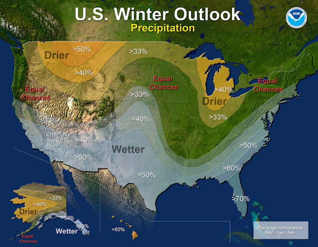
NOAA’s outlook shows a pretty typical El Niño situation with some locations of the nation expected to receive copious amounts of moisture.  For us, it does point to a bit better chance of a wetter than normal period from December to February.

Read the complete text of NOAA’s outlook below.  At the bottom is the video they released to accompany it.

From NOAA:

Precipitation - U.S. Winter Outlook: 2015-2016. Click for larger view. (NOAA)
Precipitation – U.S. Winter Outlook: 2015-2016. Click for larger view. (NOAA)

Forecasters at NOAA’s Climate Prediction Center issued the U.S. Winter Outlook today favoring cooler and wetter weather in Southern Tier states with above-average temperatures most likely in the West and across the Northern Tier. This year’s El Niño, among the strongest on record, is expected to influence weather and climate patterns this winter by impacting the position of the Pacific jet stream.

“A strong El Niño is in place and should exert a strong influence over our weather this winter,” said Mike Halpert, deputy director, NOAA’s Climate Prediction Center. “While temperature and precipitation impacts associated with El Niño are favored, El Niño is not the only player. Cold-air outbreaks and snow storms will likely occur at times this winter. However, the frequency, number and intensity of these events cannot be predicted on a seasonal timescale.”

Other factors that often play a role in the winter weather include the Arctic Oscillation, which influences the number of arctic air masses that penetrate into the South and nor’easters on the East Coast, and the Madden-Julian Oscillation, which can impact the number of heavy rain storms in the Pacific Northwest.

The 2015 U.S. Winter Outlook (December through February):

Precipitation Outlook:

  • Wetter-than-average conditions most likely in the Southern Tier of the United States, from central and southern California, across Texas, to Florida, and up the East Coast to southern New England. Above-average precipitation is also favored in southeastern Alaska.
  • Drier-than-average conditions most likely for Hawaii, central and western Alaska, parts of the Pacific Northwest and northern Rockies, and for areas near the Great Lakes and Ohio Valley.

Temperature Outlook:

  • Above-average temperatures are favored across much of the West and the northern half of the contiguous United States. Temperatures are also favored to be above-average in Alaska and much of Hawaii. Below-average temperatures are most likely in the southern Plains and Southeast.

Drought Outlook:

  • The U.S. Drought Outlook shows some improvement is likely in central and southern California by the end of January, but not drought removal. Additional statewide relief is possible during February and March. Drought removal is likely across large parts of the Southwest, while improvement or removal is also likely in the southern Plains. However, drought is likely to persist in the Pacific Northwest and northern Rockies, with drought development likely in Hawaii, parts of the northern Plains and in the northern Great Lakes region.

While it is good news that drought improvement is predicted for California, one season of above-average rain and snow is unlikely to remove four years of drought,” said Halpert. “California would need close to twice its normal rainfall to get out of drought and that’s unlikely.”

This seasonal outlook does not project where and when snowstorms may hit or provide total seasonal snowfall accumulations. Snow forecasts are dependent upon the strength and track of winter storms, which are generally not predictable more than a week in advance.

NOAA produces seasonal outlooks to help communities prepare for what’s likely to come in the next few months and minimize weather’s impacts on lives and livelihoods. Empowering people with actionable forecasts and winter weather tips is key to NOAA’s effort to build a Weather-Ready Nation.

NOAA’s mission is to understand and predict changes in the Earth’s environment, from the depths of the ocean to the surface of the sun, and to conserve and manage our coastal and marine resources. Join us on Facebook, Twitter, Instagram and our other social media channels.

Philippines braces for Typhoon Koppu

Manila (dpa) – Philippine authorities on Friday prepared evacuation plans and deployed emergency teams and relief supplies as Typhoon Koppu barrelled towards the country’s north-eastern coast. Koppu was packing maximum winds of 130 kilometres per hour (kph) and gusts of up to 160 kph as it moved west at a speed of 15 kph, the weather… Continue reading Philippines braces for Typhoon Koppu →

El Niño Won’t Relieve West’s Drought, NOAA Predicts

Updated | Federal weather forecasters released their winter outlook Thursday, and it doesn’t look good for drought-stricken northern California, Oregon and Washington state. A strong El Niño this winter is predicted to intensify the Western drought through at least January, the National Oceanic and Atmospheric Administration announced. Earlier this week, NASA released a new image of… Continue reading El Niño Won’t Relieve West’s Drought, NOAA Predicts →

Denver breaks record high temperature for October 11

Record setting high temperatures in Thornton.Temperatures this weekend were more akin to what we expect in August than what we normally see in the second week of October.  That bears out with the fact we broke the all-time record high temperature for today’s date.

At 1:46pm the temperature at Denver International Airport, Denver’s official station, topped out at 87 degrees.  This easily bests the previous record high for October 11 of 85 degrees recorded in 1996 and 1975.

Here in Thornton, we matched the 87 degree reading at 2:28pm.

The extended forecast does provide for cooler temperatures for the rest of the week, however they will continue to be a good bit above average for this time of year.  Get the extended forecast here.

  • Stay up to date with Thornton’s weather: Be sure to ‘like’ us on Facebook, follow us on Twitter and add us to your Google+ circles.

NASA Outlines Plan For Humanity’s Journey To Mars

Mars, despite its inhospitable climate and heavily irradiated surface that would kill humans in a matter of minutes, has been a source of unending fascination for scientists and science fiction writers alike. In recent years, this fascination has translated into concrete plans for a manned mission to the red planet, with the goal of eventually establishing… Continue reading NASA Outlines Plan For Humanity’s Journey To Mars →

Guatemala Mudslide Death Toll May Soar

The death toll in the massive mudslide in Guatemala is likely to climb from dozens to hundreds as hopes for finding survivors faded two days after the disaster struck. At least 85 people have been confirmed dead so far in the mudslide which struck the town of El Cambray near capital, Guatemala City. “The figure we… Continue reading Guatemala Mudslide Death Toll May Soar →

Weather system deluges eastern US coast as hurricane threat eases

Sarasota, Florida (dpa) – The south-eastern US coast was likely to be spared the wrath of Hurricane Joaquin, but rainfall from a low pressure system drenched several states Saturday. Flood warnings were posted in several coastal states, reaching accumulations of up to 25 centimetres in already saturated areas. One of the worst hit was South Carolina,… Continue reading Weather system deluges eastern US coast as hurricane threat eases →

Thornton’s October preview: Fall should finally make an appearance

Thornton, Colorado October weather preview.With the first full month of fall here, October usually brings one of the quietest weather months in the Denver area with plenty of mild, sunny days and clear, cool nights.

October is historically the second sunniest month and conditions are generally calm.

However we also will usually see our first taste of winter during the month with the first freeze and first snowfall of the season.  Temperatures as well will start to drop and by the end of the month the average nighttime lows are below freezing.

For complete details on our historical October weather and what we can expect in the coming month, read our complete October weather preview here.

  • Don’t miss a thing when it comes to our ever-changing weather! Be sure to ‘like’ us on Facebook, follow us on Twitter and add us to your Google+ circles.

September 2015 weather recap: One of the warmest, driest on record

With the mercury stuck stubbornly at the top of the scale and barely a few raindrops falling into the bucket, September 2015 will be going into the books as one of the warmest and driest on record.

High pressure dominated the entire region during the month.  This allowed temperatures to consistently climb above normal and helped prevent moisture from arriving in any significant amounts.  At Denver International Airport, 27 of the 30 days had above normal temperatures.  Thornton’s overall temperatures were cooler than DIA’s but we were still quite a bit warmer than average.

The monthly average temperature in Thornton came in at 67.1 degrees.  Out at the airport where the Mile High City’s official measurements are taken, the average was 69.4 degrees.

Denver’s historical average for September is 63.4 so both locations came in well above normal.  Officially, September 2015 ranks as the warmest September on record, easily jumping to the number one spot over September 1948 which had an average of 68.3 degrees.

Undoubtedly the big difference between measurements at DIA and other locations in the metro area are yet another example of the airport’s readings consistently being an outlier from the reality seen in more populated areas.  This has been an ongoing problem since the National Weather Service moved the official station from Stapleton.

The warmest mercury reading in Thornton during the month was 94 degrees on the 13th.  The coldest came on the 19th when temperatures dipped to 40 degrees in the early morning hours.  Eight days in Thornton topped out above the 90 degree mark.

At the airport, Denver’s warmest reading of 92 degrees came on September 2.  It’s coldest on September 19 (44 degrees).  The airport saw seven days with above 90 degree maximums.

Just as the month was exceedingly warm, it also was very dry.  Thornton saw a mere 0.09 inches fall in its rain bucket and Denver recorded 0.11 inches.  Both were far short of the September precipitation average of 0.96 inches.

DIA’s measurement means September 2015 goes into the books with the 9th least amount of precipitation in September since 1872 (16th driest overall).

Click here to view Thornton’s September 2015 climate report.

Thornton, Colorado's September 2015 temperature summary. (ThorntonWeather.com)
Thornton, Colorado’s September 2015 temperature summary. (ThorntonWeather.com)
Thornton, Colorado's September 2015 precipitation summary. (ThorntonWeather.com)
Thornton, Colorado’s September 2015 precipitation summary. (ThorntonWeather.com)

From the National Weather Service:

CLIMATE REPORT
NATIONAL WEATHER SERVICE BOULDER, CO
244 AM MDT THU OCT 1 2015

...THE DENVER CO CLIMATE SUMMARY FOR THE MONTH OF SEPTEMBER 2015... 

CLIMATE NORMAL PERIOD 1981 TO 2010
CLIMATE RECORD PERIOD 1872 TO 2015

WEATHER         OBSERVED          NORMAL  DEPART  LAST YEAR`S
                 VALUE   DATE(S)  VALUE   FROM    VALUE  DATE(S)
                                          NORMAL
................................................................ 
TEMPERATURE (F)
RECORD
 HIGH              97   09/06/2013
                        09/05/2013
                        09/04/1995
 LOW               17   09/29/1985
HIGHEST            92   09/02        91       1       94  09/03
LOWEST             44   09/19        35       9       33  09/12
AVG. MAXIMUM     85.2              78.5     6.7     78.9
AVG. MINIMUM     53.5              48.3     5.2     50.6
MEAN             69.4              63.4     6.0     64.8
DAYS MAX >= 90      7               3.4     3.6        2
DAYS MAX <= 32      0               0.0     0.0        0
DAYS MIN <= 32      0               0.8    -0.8        0
DAYS MIN <= 0 0 0.0 0.0 0 

PRECIPITATION (INCHES) 
RECORD
 MAXIMUM 5.61 2013
 MINIMUM T 1892 1944 
TOTALS 0.11 0.96 -0.85 1.79 
DAILY AVG. 0.00 0.03 -0.03 0.06 
DAYS >= .01         3               6.5    -3.5        9
DAYS >= .10         0               3.3    -3.3        4
DAYS >= .50         0               0.6    -0.6        1
DAYS >= 1.00        0               0.1    -0.1        1
GREATEST
 24 HR. TOTAL    0.12   08/31 TO 09/01           09/29 TO 09/29
                                                          09/28 TO 09/29
                                                          09/29 TO 09/29
 STORM TOTAL       MM                                 MM
 (MM/DD(HH))            MM                    09/29(00) TO 09/29(00)
                                                 09/29(00) TO 09/29(00)9
                                                 09/29(00) TO 09/29(00)9

SNOWFALL (INCHES)
RECORDS
 TOTAL             MM   MM
TOTALS            0.0               1.3

DEGREE_DAYS
HEATING TOTAL       9               125    -116       91
 SINCE 7/1         27               141    -114       98
COOLING TOTAL     148                76      72       88
 SINCE 1/1        861               764      97      701

FREEZE DATES
RECORD
 EARLIEST     09/08/1962
 LATEST       06/08/2007
EARLIEST                        10/07
LATEST                          05/05
.......................................................... 

WIND (MPH)
AVERAGE WIND SPEED              9.0
RESULTANT WIND SPEED/DIRECTION   2/195
HIGHEST WIND SPEED/DIRECTION    35/280    DATE  09/07
HIGHEST GUST SPEED/DIRECTION    54/270    DATE  09/07

SKY COVER
POSSIBLE SUNSHINE (PERCENT)   MM
AVERAGE SKY COVER           0.40
NUMBER OF DAYS FAIR           12
NUMBER OF DAYS PC             17
NUMBER OF DAYS CLOUDY          1

AVERAGE RH (PERCENT)     41

WEATHER CONDITIONS. NUMBER OF DAYS WITH
THUNDERSTORM              6     MIXED PRECIP               0
HEAVY RAIN                0     RAIN                       3
LIGHT RAIN                7     FREEZING RAIN              0
LT FREEZING RAIN          0     HAIL                       3
HEAVY SNOW                0     SNOW                       0
LIGHT SNOW                0     SLEET                      0
FOG                       3     FOG W/VIS <= 1/4 MILE      5
HAZE                      1

-  INDICATES NEGATIVE NUMBERS.
R  INDICATES RECORD WAS SET OR TIED.
MM INDICATES DATA IS MISSING.
T  INDICATES TRACE AMOUNT.