The Farmers’ Almanac released its 2025 – 2026 winter outlook and if it were to bear out, Colorado could be in for some harsh, wintry weather.
The publication portends a “very cold, snowy” winter for the north central plains. It says the region is, “set for a classic winter wonderland.”
Founded in 1818, the Farmers’ Almanac’s forecasts use a “tried-and-true formula that adapts to the mysteries of nature and the ever-changing world in which we live. The basis of our prediction method was developed by our founding editor according to correlations between celestial events, and various meteorological conditions.”
Of course, long range forecasts this far out, no matter who is making them, have to be taken with a grain of salt. However, as Thornton has seen four straight snow seasons with below normal levels of the white stuff, a change might be welcome.
Winter officially begins at 2:21am MST on Saturday, December 21, 2024.
Astronomical winter arrives in Thornton early Saturday morning and with the solstice also comes the shortest day of the year.
Winter officially begins at 2:21am MST on Saturday, December 21, 2024.
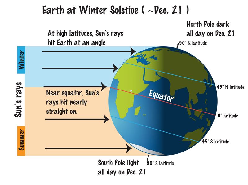
The Winter Solstice occurs when the North Pole is tilted at its furthest from the sun – 23.5 degrees away. This results in the shortest day of the year in the Northern Hemisphere.
Here in Denver, with sunrise at 7:17am and sunset at 4:39pm, our day Saturday will be 9 hours, 21 minutes and 15 seconds long.
The following day, Sunday, it will be about three seconds longer and each day from now through to the Summer Solstice in June will get gradually longer as well.
While we have a short day on the solstice, it is nothing like what will be experienced in the Arctic Circle. Areas north of there to the North Pole will have no direct sunlight at all. Conversely, areas south of the Antarctic Circle toward the South Pole will have 24 hours of daylight and have a midnight sun.
Did you know that there is a difference between the astronomical seasons that we are discussing here and meteorological seasons?
Meteorological seasons differ slightly and are geared toward matching the calendar with the annual temperature cycle. This is done primarily for meteorological observing and forecasting and in many ways it is more logical than the astronomical seasons.
For the Northern Hemisphere, the meteorological spring covers the months of March, April and May. Summer brings the hottest months of the year and so meteorological summer is June, July and August. Meteorological fall then is September, October and November followed by the coldest months of December, January and February as meteorological winter.
Winter officially begins at 8:27pm MST on Thursday, December 21, 2023.
Astronomical winter arrives in Thornton Thursday evening and with the solstice also comes the shortest day of the year.
Winter officially begins at 8:27pm MST on Thursday, December 21, 2023.
The Winter Solstice occurs when the North Pole is tilted at its furthest from the sun – 23.5 degrees away. This results in the shortest day of the year in the Northern Hemisphere.
Here in Denver, with sunrise at 7:17am and sunset at 4:38pm, our day Saturday will be 9 hours, 21 minutes and 14 seconds long.
The following day, Friday, it will be about a second longer and each day from now through to the Summer Solstice in June will get gradually longer as well.
While we have a short day on the solstice, it is nothing like what will be experienced in the Arctic Circle. Areas north of there to the North Pole will have no direct sunlight at all. Conversely, areas south of the Antarctic Circle toward the South Pole will have 24 hours of daylight and have a midnight sun.
Did you know that there is a difference between the astronomical seasons that we are discussing here and meteorological seasons?
Meteorological seasons differ slightly and are geared toward matching the calendar with the annual temperature cycle. This is done primarily for meteorological observing and forecasting and in many ways it is more logical than the astronomical seasons.
For the Northern Hemisphere, the meteorological spring covers the months of March, April and May. Summer brings the hottest months of the year and so meteorological summer is June, July and August. Meteorological fall then is September, October and November followed by the coldest months of December, January and February as meteorological winter.
Winter officially begins at 9:28am MST on Thursday, December 21, 2017. (NOAA)
Astronomical winter arrives in Thornton Saturday evening and with the solstice also comes the shortest day of the year.
Winter officially begins at 9:19pm MST on Saturday, December 21, 2019.
The Winter Solstice occurs when the North Pole is tilted at its furthest from the sun – 23.5 degrees away. This results in the shortest day of the year in the Northern Hemisphere.
Here in Denver, with sunrise at 7:17am and sunset at 4:38pm, our day Saturday will be 9 hours, 21 minutes and 16 seconds long.
The following day, Sunday, it will be about a second longer and each day from now through to the Summer Solstice in June will get gradually longer as well.
While we have a short day on the solstice, it is nothing like what will be experienced in the Arctic Circle. Areas north of there to the North Pole will have no direct sunlight at all. Conversely, areas south of the Antarctic Circle toward the South Pole will have 24 hours of daylight and have a midnight sun.
Did you know that there is a difference between the astronomical seasons that we are discussing here and meteorological seasons?
Meteorological seasons differ slightly and are geared toward matching the calendar with the annual temperature cycle. This is done primarily for meteorological observing and forecasting and in many ways it is more logical than the astronomical seasons.
For the Northern Hemisphere, the meteorological spring covers the months of March, April and May. Summer brings the hottest months of the year and so meteorological summer is June, July and August. Meteorological fall then is September, October and November followed by the coldest months of December, January and February as meteorological winter.
Winter officially begins at 9:28am MST on Thursday, December 21, 2017. (NOAA)
Astronomical winter arrives in Thornton Friday afternoon and with the solstice also comes the shortest day of the year.
Winter officially begins at 3:23pm MST on Friday, December 21.
The Winter Solstice occurs when the North Pole is tilted at its furthest from the sun – 23.5 degrees away. This results in the shortest day of the year in the Northern Hemisphere.
Here in Denver, with sunrise at 7:17am and sunset at 4:38pm, our day Friday will be 9 hours, 21 minutes and 16 seconds long.
The following day, Saturday, it will be one second longer and each day from now through to the Summer Solstice in June will get gradually longer as well.
While we have a short day today, it is nothing like what will be experienced in the Arctic Circle. Areas north of there to the North Pole will have no direct sunlight at all. Conversely, areas south of the Antarctic Circle toward the South Pole will have 24 hours of daylight and have a midnight sun.
Did you know that there is a difference between the astronomical seasons that we are discussing here and meteorological seasons?
Meteorological seasons differ slightly and are geared toward matching the calendar with the annual temperature cycle. This is done primarily for meteorological observing and forecasting and in many ways it is more logical than the astronomical seasons.
For the Northern Hemisphere, the meteorological spring covers the months of March, April and May. Summer brings the hottest months of the year and so meteorological summer is June, July and August. Meteorological fall then is September, October and November followed by the coldest months of December, January and February as meteorological winter.
Winter officially begins at 9:28am MST on Thursday, December 21, 2017. (NOAA)
Astronomical winter arrives in Thornton Thursday morning and with the solstice also comes the shortest day of the year. Mother Nature as well appears set to bring in winter with a bit of a bang and a change in our recent mild, dry weather pattern.
Winter officially begins at 9:28am MST on Thursday, December 21.
The Winter Solstice occurs when the North Pole is tilted at its furthest from the sun – 23.5 degrees away. This results in the shortest day of the year in the Northern Hemisphere.
Here in Denver, with sunrise at 7:17am and sunset at 4:38pm, our day Thursday will be 9 hours, 21 minutes and 16 seconds long. The following day, Friday, it will be three seconds longer and each day from now through to the Summer Solstice in June will get gradually longer as well.
While we have a short day today, it is nothing like what will be experienced in the Arctic Circle. Areas north of there to the North Pole will have no direct sunlight at all. Conversely, areas south of the Antarctic Circle toward the South Pole will have 24 hours of daylight and have a midnight sun.
Did you know that there is a difference between the astronomical seasons that we are discussing here and meteorological seasons?
Meteorological seasons differ slightly and are geared toward matching the calendar with the annual temperature cycle. This is done primarily for meteorological observing and forecasting and in many ways it is more logical than the astronomical seasons.
For the Northern Hemisphere, the meteorological spring covers the months of March, April and May. Summer brings the hottest months of the year and so meteorological summer is June, July and August. Meteorological fall then is September, October and November followed by the coldest months of December, January and February as meteorological winter.
What will this winter have in store for Thornton? Forecasters at the Climate Prediction Center have released their outlook and for the Front Range, it doesn’t hold much in the way of clues.
The CPC does show odds favor above average temperatures for much of Colorado for the period from December through February. In terms of precipitation, the agency gives equal chances of near average, well above average, or well below average precipitation for most of the state. The one exception is the southern third of Colorado which they peg at having above average chances of a drier than normal year.
From NOAA:
U.S. Winter Outlook predicts warmer, drier South and cooler, wetter North
Drought expected to persist in California and expand in the Southeast
Winter 2016 – 2017 temperature outlook. Click for larger view. (NOAA)
October 20, 2016 – Forecasters at NOAA’s Climate Prediction Center issued the U.S. Winter Outlook today, saying that La Nina is expected to influence winter conditions this year. The Climate Prediction Center issued a La Nina watch this month, predicting the climate phenomenon is likely to develop in late fall or early winter. La Nina favors drier, warmer winters in the southern U.S and wetter, cooler conditions in the northern U.S. If La Nina conditions materialize, forecasters say it should be weak and potentially short-lived.
“This climate outlook provides the most likely outcome for the upcoming winter season, but it also provides the public with a good reminder that winter is just up ahead and it’s a good time to prepare for typical winter hazards, such as extreme cold and snowstorms,” said Mike Halpert, deputy director, NOAA’s Climate Prediction Center. “Regardless of the outlook, there is always some chance for extreme winter weather, so prepare now for what might come later this winter.”
Other factors that often play a role in the winter weather include theArctic Oscillation, which influences the number of arctic air masses that penetrate into the South and create nor’easters on the East Coast, and the Madden-Julian Oscillation, which can affect the number of heavy rain events in the Pacific Northwest.
The 2016 U.S. Winter Outlook (December through February):
Wetter than normal conditions are most likely in the northern Rockies, around the Great Lakes, in Hawaii and in western Alaska
Drier than normal conditions are most likely across the entire southern U.S. and southern Alaska.
Temperature
Warmer than normal conditions are most likely across the southern U.S., extending northward through the central Rockies, in Hawaii, in western and northern Alaska and in northern New England.
Cooler conditions are most likely across the northern tier from Montana to western Michigan.
The rest of the country falls into the “equal chance” category, meaning that there is not a strong enough climate signal in these areas to shift the odds, so they have an equal chance for above-, near-, or below-normal temperatures and/or precipitation.
Drought
Drought will likely persist through the winter in many regions currently experiencing drought, including much of California and the Southwest
Drought is expected to persist and spread in the southeastern U.S. and develop in the southern Plains.
New England will see a mixed bag, with improvement in the western parts and persistence to the east.
Drought improvement is anticipated in northern California, the northern Rockies, the northern Plains and parts of the Ohio Valley.
This seasonal outlook does not project where and when snowstorms may hit or provide total seasonal snowfall accumulations. Snow forecasts are dependent upon the strength and track of winter storms, which are generally not predictable more than a week in advance. However, La Nina winters tend to favor above average snowfall around the Great Lakes and in the northern Rockies and below average snowfall in the mid-Atlantic.
NOAA produces seasonal outlooks to help communities prepare for what’s likely to come in the next few months and minimize weather’s impacts on lives and livelihoods. Empowering people with actionable forecasts and winter weather tips is key to NOAA’s effort to build aWeather-Ready Nation.
Astronomical winter arrives in Thornton today and with the solstice also comes the shortest day of the year.
Winter officially begins at 4:03pm today. The Winter Solstice occurs when the North Pole is tilted at its furthest from the sun – 23.5 degrees away. This results in the shortest day of the year in the Northern Hemisphere.
Here in Denver, with sunrise at 7:18am and sunset at 4:39pm, our day today is 9 hours, 21 minutes and 13 seconds long. Tomorrow it will be one second longer and each day from now through to the Summer Solstice in June will get gradually longer as well.
Did you know that there is a difference between the astronomical seasons that we are discussing here and meteorological seasons?
Meteorological seasons differ slightly and are geared toward matching the calendar with the annual temperature cycle. This is done primarily for meteorological observing and forecasting and in many ways it is more logical than the astronomical seasons.
For the Northern Hemisphere, the meteorological spring covers the months of March, April and May. Summer brings the hottest months of the year and so meteorological summer is June, July and August. Meteorological fall then is September, October and November followed by the coldest months of December, January and February as meteorological winter.
Strengthening La Niña conditions in the Pacific could lead to another dry winter on the Colorado Front Range according to the winter 2011 / 2012 outlook released by NOAA. However, as we well know, Mother Nature is never consistent and other factors could give us some help.
While temperatures in the Equatorial Pacific Ocean are indeed cooler than normal – and getting cooler – at this point they remain warmer than they were last year at this same time. This does help us hold out some hope that the winter won’t be as dry as last year.
It should also be noted that the effects of La Niña and El Niño in Colorado are much harder to predict and less consistent than in other places in the nation. Our location near the middle of the country with the monstrous Rocky Mountains adjacent to us oftentimes throws a wrench in the works.
U.S. dealt another La Niña winter but ‘wild card’ could trump it Devastating drought in Southern Plains likely to continue
NOAA's winter 2011 temperature outlook. Click the image for a larger view.
The Southern Plains should prepare for continued drier and warmer than average weather, while the Pacific Northwest is likely to be colder and wetter than average from December through February, according to the annual Winter Outlook released today by NOAA.
For the second winter in a row, La Niña will influence weather patterns across the country, but as usual, it’s not the only climate factor at play. The ‘wild card’ is the lesser-known and less predictable Arctic Oscillation that could produce dramatic short-term swings in temperatures this winter.
NOAA expects La Niña, which returned in August, to gradually strengthen and continue through the upcoming winter. It is associated with cooler than normal water temperatures in the tropical Pacific Ocean and influences weather throughout the world.
“The evolving La Niña will shape this winter,” said Mike Halpert, deputy director of NOAA’s Climate Prediction Center. “There is a wild card, though. The erratic Arctic Oscillation can generate strong shifts in the climate patterns that could overwhelm or amplify La Niña’s typical impacts.”
The Arctic Oscillation is always present and fluctuates between positive and negative phases. The negative phase of the Arctic Oscillation pushes cold air into the U.S. from Canada. The Arctic Oscillation went strongly negative at times the last two winters, causing outbreaks of cold and snowy conditions in the U.S. such as the “Snowmaggedon” storm of 2009. Strong Arctic Oscillation episodes typically last a few weeks and are difficult to predict more than one to two weeks in advance.
NOAA's winter 2011 precipitation outlook. Click the image for a larger view.
With La Niña in place Texas, Oklahoma, New Mexico and parts of surrounding states are unlikely to get enough rain to alleviate the ongoing drought. Texas, the epicenter of the drought, experienced its driest 12-month period on record from October 2010 through September 2011.
Stormy periods can occur anytime during the winter season. To improve the ability to predict and track winter storms, NOAA implemented a more accurate weather forecast model on Oct.18. Data gathered from the model will support local weather forecast office efforts to prepare for and protect the public from weather events. This service is helping the country to become a Weather-Ready Nation at a time when extreme weather is on the rise.
According to the U.S. Winter Outlook (December through February) odds tilt in favor of:
Pacific Northwest: colder and wetter than average. La Niña often results in below-average temperatures and increased mountain snow in the Pacific Northwest and western Montana during the winter months. This may set the stage for spring flooding in the Missouri River Basin;
California: colder than average and wetter than average conditions in northern California and drier than average conditions in southern California. All of the southern part of the nation are at risk of having above normal wildfire conditions starting this winter and lasting into the spring;
Northern Plains: colder and wetter than average. Spring flooding could be a concern in parts of this region;
Southern Plains and Gulf Coast States: warmer and drier than average. This will likely exacerbate drought conditions in these regions;
Florida and south Atlantic Coast: drier than average, with an equal chance for above-, near-, or below-normal temperatures. Above normal wildfire conditions;
Ohio and Tennessee Valleys: wetter than average with equal chances for above-, near-, or below-average temperatures. Potential for increased storminess and flooding;
Northeast and Mid-Atlantic: equal chances for above-, near-, or below-normal temperatures and precipitation. Winter weather for these regions is often driven not by La Niña but by the Arctic Oscillation. If enough cold air and moisture are in place, areas north of the Ohio Valley and into the Northeast could see above-average snow;
Great Lakes: colder and wetter than average;
Hawaii: above-average temperatures in the western islands with above normal precipitation during the winter. Some drought recovery is expected across the state with Kauai and Oahu having the best potential for full recovery.
Alaska: colder than average over the southern half of the state and the panhandle with below average precipitation in the interior eastern part of the state.
This seasonal outlook does not project where and when snowstorms may hit or provide total seasonal snowfall accumulations. Snow forecasts are dependent upon winter storms, which are generally not predictable more than a week in advance.
Weather, natural disasters & climate news and information.