June 15, 1988 – Tornadoes strike Denver, Colorado. (ThorntonWeather.com)
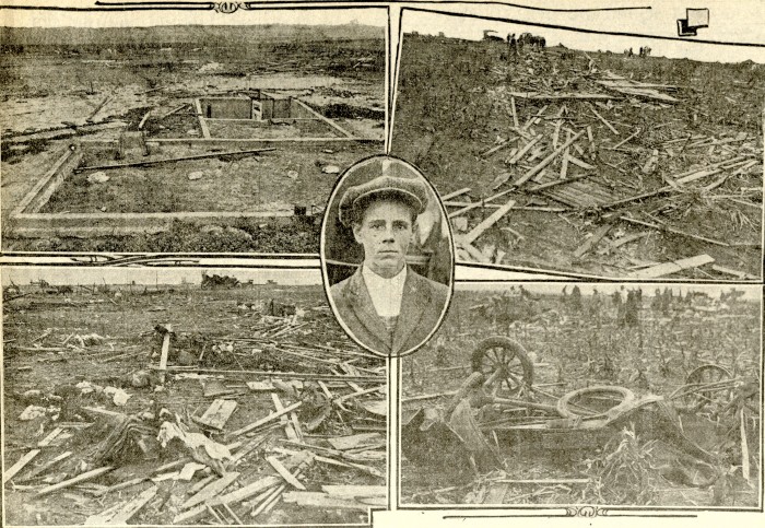
This was a fun find! I was going through old family photos and came across these images of a famous – and destructive – Denver weather event.
At that time, I was staying with my sister at her house on Fox Street near 96th Ave in Thornton. The weather was clearly getting spicy and where she lived provided clear views to the south and southeast.
We were amazed to watch multiple twisters strike in and around the city, me grabbing pictures with my old 35mm Canon AE-1 Program.
The National Weather Service history for the event describes “several” tornadoes. The most powerful was an F3 that struck in south Denver and was on the ground for 25 minutes. That twister alone damaged 85 buildings and many vehicles. Miraculously, no serious injuries or deaths were reported.
Below see more pictures I took that day and you can read the official account from the NWS and watch some archived news stories from the day.
From the National Weather Service:
In 1988…several tornadoes developed across metro Denver. One tornado touched down just northeast of the rocky mountain arsenal. The twister moved very slowly and did no damage…except to demolish a small electrical substation… Even though it was on the ground for nearly 30 minutes. Later…another tornado was sighted east of Brighton about 2 miles north of Barr Lake. An f2 tornado cut a swath through northeast Denver. The main path went through a thickly wooded area for about 6 blocks and uprooted about 500 city owned trees…many of them large elms 75 to 100 years old. Hundreds of privately owned trees were also sucked from the ground by the slow moving twister…which was filmed by a news team in a helicopter as it uprooted trees. The replacement cost to the city owned trees was estimated at 1.5 million dollars. The twister did little damage to buildings. Some homes suffered roof and chimney damage…a gas main was ruptured…and some cars were damaged by falling trees. The uprooted trees also caused curb and sidewalk damage and cut some electrical wires. The funnel cloud passed close to Stapleton International Airport. Aircraft operations were shut down…and the tower was evacuated. The tornado was on the ground for almost 25 minutes. An f3 tornado cut an erratic path through south Denver for about 25 minutes…causing extensive damage in at least 3 areas. The twister damaged about 85 buildings… 20 severely; the total loss was estimated at 5 to 10 million dollars. Many cars were severely damaged; at least 15 vehicles were overturned. One trailer was lifted onto the top of a building that had just been unroofed; numerous antique cars inside the building were damaged. A Ford Bronco was blown over a church…and landed 100 yards away. A metal storage shed was deposited far above the ground in some power lines. The tornado uprooted many trees on a golf course. No one was seriously hurt…although seven people suffered minor injuries from flying debris. A golfer was thrown 40 feet…but was not hurt; a man clinging to a telephone pole was unscathed…but lost both shoes…a sock…and buttons off his shirt. A woman holding a baby was sucked through a broken convenience store window… But was unhurt. A dog…tethered to the ground by its leash… Was suspended in the air by the twister. Uprooted trees crushed cars and damaged curbs and sidewalks. People in downtown Denver could see three tornadoes occurring simultaneously. Hail as large as 1 3/8 inches in diameter fell in extreme southeast Aurora.
May 18, 2025 – A tornado touches down near Bennett. (Arapahoe County Sherriff’s office)
The National Weather Service has completed their damage assessments of this past Sunday’s tornadoes in Arapahoe and Adams counties. The service tallied four twisters, three rated EF-2 and one EF-1.
The largest of the twisters, northeast of Bennett, hit an estimated peak wind speed of 112 mph. Its damage path was nearly five miles long and at times, 400 yards wide. It was on the ground for 15 minutes.
A second twister before that one started in Arapahoe County and ended in Adams. It saw max winds of 125 mph, a path just over 5 miles long and a maximum width of 200 yards.
Public Information Statement…CORRECTED
National Weather Service Denver/Boulder CO
1153 AM MDT Wed May 21 2025
…NWS Damage Survey for 05/18/25 Tornado Event…
Overview…Four tornadoes occurred just to the south and east of metro Denver in the early afternoon of Sunday, May 18th. The first tornado that produced damage in northwest Elbert County was an uncharacteristically strong landspout, as well at the last tornado that occurred northeast of Bennett. The other two tornadoes were more strongly associated with a parent thunderstorm, known as a supercell.
The following information is for four separate tornado tracks surveyed on May 19th. The first is for the initial tornado, rated EF2, in and near the Elkhorn neighborhood of extreme northwest Elbert County, Colorado. The second is an EF1 that occurred south of Manila Village. The third and fourth tornadoes were both ranked EF2. These tornadoes tracked just to the west and north of Bennett, Colorado. They were two separate tornadoes, and were both on the ground at the same time between 140 pm and 146 pm. All data is preliminary and subject to change as new information is received.
May 18, 2025 – A tornado touches down near Bennett. (Arapahoe County Sherriff’s office)
Two confirmed tornadoes struck just east of Denver Sunday. The National Weather Service has given both twisters a preliminary rating of EF2 with winds between 111 and 135mph. As many as 36 structures, a dozen of which were homes, were damaged.
Some absolutely stunning photos and videos have emerged from the event but arguably none more scary than this one. Taken by Fer Romo’s dashcam, it shows the person fleeing in a truck as the tornado in Elbert County rips about a home.
Images from the Rocky Mountain News showing the devastation after a tornado struck near Thurman, Colorado on August 10, 1924.
The National Weather Service did a fantastic writeup about this devastating event on August 10, 1924 that claimed the lives of 11 people, 9 of which were children. It is a fascinating read. Check it out here.
From Microsoft Copilot:
The 1924 Thurman Tornado is the deadliest tornado in Colorado’s history. Here are some key details:
Insane dashcam video of a man driving through the EF-3 tornado that struck Clarksville, Tennessee on Saturday. Six people were killed in the series of storms. Read the National Weather Service’s summary of the event here.
Supercell thunderstorms like this can be beautiful – but they can also be deadly. Do you know what to do when severe weather strikes? (Stormscape Photography / FLICKR)
Over the past week we have highlighted some of the severe weather hazards that we face in Colorado every spring and summer in our Severe Weather 101 series. The dangers these present are significant and not to be taken lightly.
Tornadoes grab most of the headlines and certainly are a danger however others like lightning and flooding are more common and actually claim more lives. We ask all of our readers to please, take the time to review these important articles – they could save yours and your family’s lives!
The National Weather Service has published a nice wrap up of Severe Weather Awareness Week that covers all the basics – see it below. For more in depth information, please use the links at the bottom to view each article on our Severe Weather 101 series. Be safe and be weatherwise!
PUBLIC INFORMATION STATEMENT
NATIONAL WEATHER SERVICE GRAND JUNCTION CO
600 AM MDT SAT APR 16 2022
SEVERE WEATHER AWARENESS WEEK IN REVIEW
Severe Weather Awareness Week in review…
Severe Weather Awareness Week in Colorado concludes today. During the past week we have presented information and safety rules for tornadoes, lightning and wildfires, floods and flash floods, straight-line thunderstorm winds, hail, and our warning programs.
We will now review some of the most important safety rules in our effort to build a Weather-Ready Nation.
Be weather-wise by staying informed on expected weather in your area. The National Weather Service is typically aware of the potential for severe weather many hours or even days before any severe weather watches or warnings are issued, providing forecast products to heighten your awareness. A Weather Story product is posted each day on National Weather Service Internet pages and Facebook pages which includes a map and text on possible hazardous weather expected within the next seven days.
A Hazardous Weather Outlook is also issued daily with information on possible hazardous weather through the next seven days. A watch is issued when conditions for severe weather or flooding become possible. A warning is then issued when life threatening conditions are imminent or occurring.
Tornadoes can even strike in mountain areas. In 2008 on August 23rd, this rope tornado struck Park County near Eleven Mile Reservoir. Image courtesy Jerry Bivens.
The best way to protect yourself from tornadoes is to have a plan of action. The safest place to be if a tornado approaches is in a basement or safe room within a well-built structure, or in an underground storm shelter. If none of these options are available, move to a hallway or a small interior room on the lowest floor, usually this is a closet or bathroom. Get under a heavy piece of furniture or in a bath tub and cover yourself with blankets. Remember, the greatest risk of injury from tornadoes is from flying debris.
Modular homes and mobile homes, even those tied down, offer little protection from tornadoes. If a tornado approaches, leave those locations and seek safety in a nearby sturdy building or storm shelter.
If you are driving in open country and see a tornado, if time permits, the best thing to do is simply drive away from the tornado path. Do not take shelter beneath a highway overpass. Wind speeds may actually be higher in these areas and often become collection points for debris.
If you are caught outside and cannot seek shelter inside a sturdy structure, crawl into a culvert or lie down in a narrow ditch or ravine and cover your head. But remember that the worst place to be when a tornado threatens is outside in the midst of flying debris.
Lightning usually kills and injures more people in Colorado than any other thunderstorm hazard. Lightning also causes many wildfires.
The best defense to protect yourself against a lightning strike is to plan ahead and avoid being caught where you might be vulnerable. Check weather forecasts prior to venturing out, especially if you are heading into the mountains. Plan outdoor activities early in the day before storms develop.
If thunderstorms threaten, seek shelter in a building or in an enclosed metal-roof vehicle, making sure all windows and doors are closed. Never seek shelter under an isolated tree. During thunderstorms, stay off corded telephones, away from electrical devices, and away from plumbing. Also get out of shower stalls, bath tubs, swimming pools and lakes when lightning is nearby.
You should wait at least 30 minutes after the last sound of thunder before resuming outdoor activities. When thunder roars…go indoors.
The Big Thompson Flood in 1976 claimed the lives of 144 Coloradoans and serves to remind us of the dangers of floods. (USGS)
When flooding or flash flooding is possible, you should remain alert and be ready to quickly evacuate to higher ground or climb to safety. Flash floods often occur suddenly and without warning. You need to follow some basic flood safety rules:
Do not camp or park your vehicle along streams and washes, particularly during threatening conditions.
If you are near a river, be aware of water levels and be prepared to move to higher ground if river levels rise.
Do not enter areas that are already flooded.
If walking or fishing along a river, be aware that erosion from swift running water can cause river banks to collapse.
Never let your children play around high water, storm drains, viaducts or arroyos.
At least half of all flash flood fatalities are vehicle related. While driving your automobile, look out for flooding at highway dips, bridges and low areas. Two feet of moving water will carry away most vehicles. Never attempt to drive across a flooded road. And be especially cautious at night when it is difficult to see flood dangers.
Straight-line winds from thunderstorms, including microbursts, can become quite strong, even reaching speeds in excess of 100 mph in extreme cases. When thunderstorms approach, high winds can suddenly develop, causing things on the ground to become swift moving airborne missiles with a potential force to injure or kill. As with any thunderstorm, seek shelter before the storm arrives.
This is one of the largest recorded hail stones which is more than 7 inches in diameter and fell in Nebraska in 2003. (NOAA)
Large hail can pose a danger to animals and people. Hail also produces considerable damage to crops and personal property each year in Colorado. Again, get indoors before thunderstorms arrive. A fall of small hail can suddenly change to a fall of very large ice missiles which can injure or kill. Make efforts to protect personal property before storms threaten.
When thunderstorms threaten, tune to NOAA All-Hazards Weather Radio, The Weather Channel, or your local radio or television stations. Also check the Internet web site from the National Weather Service office serving your area. And if you have a relatively new cell phone you should receive Tornado and Flash Flood Warnings on your phone if you are in the area of the warning.
During threatening weather days, plan the actions you will need to take so that you will be prepared if dangerous weather conditions actually develop.
NOAA’s National Weather Service wishes you a safe severe weather season.
Severe Weather Awareness Week in Colorado concludes today. During the past week we have presented information and safety rules for tornadoes, lightning and wildfires, floods and flash floods, straight-line thunderstorm winds, hail, and our warning programs.
This is a recap of a five part series on Colorado’s severe weather.
The 2008 Windsor Tornado highlights the very real danger twisters present in Colorado. Do you know when to do when one strikes?
One fact that may surprise those new to Colorado is that we are actually on the western edge of the infamous Tornado Alley. This large swath of land comprises much of the nation’s midsection and is a unique place as the United States sees more tornadoes than any other place on earth. In fact, tornadoes have been recorded in all 50 states including Alaska and Hawaii.
Closer to home, Colorado sees our share of these storms. In fact, one metro area county – Weld County – holds the distinction of being the “tornado capital of the world.” With 252 tornados from 1950-2011, no single county in the nation has had more tornadoes! Adams County is number two in the state and isn’t far behind with 156 over that same period. Granted these numbers are skewed a bit simply due to the sheer size of those counties, but it does serve to highlight the real danger that tornadoes present.
One common myth is that tornadoes don’t strike metropolitan areas. This has been disproved many times including here in Colorado in 1981 when an F2 tornado struck Thornton. Image courtesy the City of Thornton archives.
The most well known tornado outbreak in the metro area occurred on June 15, 1988. Five tornadoes resulted in seven injuries and damage in excess of $15 million.
The greatest threat for tornadoes occurs during late spring and early summer when you have a combination of heat and moisture in the lower atmosphere. Here in Colorado, tornadoes are frequent from May through August with June being the most active month.
Colorado ranks 10th in terms of the number of tornadoes with 1,911 events from 1950-2011. One good thing is that our high altitude and drier air do make it harder for the monster supercells that spawn the biggest tornadoes to form. Most of our tornadoes are small and short lived. Further, thanks to the wide open spaces of the eastern half of our state, many strike sparsely populated areas. This is reflected in the fact that we rank 38th for tornado related deaths.
In 1981 a tornado ripped through Thornton and caused major damage. Last year, funnel clouds were spotted across much of the area. Image courtesy City of Thornton archives.
As is customary as we get further into spring, this coming week has been proclaimed Severe Weather Awareness Week. This is an opportunity for the public to get reacquainted with the dangers severe weather presents in Colorado.
Tornadoes, lightning, hail, severe wind and flooding are very real hazards that Coloradans face every year during severe weather season. It is important that you know what to do to protect you and your family.
Just 12 years ago in what was Denver’s weather story of the year, we suffered through a period of unusually severe weather including a tornado that ripped through the Southlands Mall.
Thirteen years ago on May 22nd an EF3 tornado raced north through Weld and Larimer counties resulting in one fatality near Windsor and causing several injuries and destroyed or heavily damaged hundreds of homes.
In conjunction with the National Weather Service’s statements on Severe Weather Awareness Week, ThorntonWeather.com will be publishing our Severe Weather 101 series. Each day this week a weather hazard will be discussed in depth and we will outline protective measures you can take to keep yourself and your family safe. Please be sure to check back every day to read these important message.
Update: 11:15 p.m. EDT — Athletic Director at Jacksonville State University Greg Seitz tweeted confirming Jacksonville’s Coliseum has indeed incurred extensive damages due to the tornado. “My bestfriend is stuck at the Reservse [sic] in Jacksonville right now. Other tenants came to her apartment because theirs was flooding. At her apartment water started coming under the… Continue reading Tornado Hits Jacksonville, Alabama [Photos, Videos]→
Tulsa, Okla., residents woke up to the devastation of an EF2 tornado that hit the town overnight, reports FOX23. 12:50pm – Survey team confirms tornado damage across central Tulsa. EF2 intensity also confirmed. Survey continues. Watch the video — NWS Tulsa (@NWStulsa) August 6, 2017 The tornado hit shortly after 1 AM, destroying multiple businesses. There… Continue reading Images the day after a dangerous Oklahoma tornado show the destruction it left in its wake→
Weather, natural disasters & climate news and information.