
Wind is always a factor on the plains and the fall usually brings a great deal of it, especially in November. Our look back at this week in Denver weather history shows that event and snow are quite common this time of year.
From the National Weather Service:
From the 7th to the 8th:
In 1969…wind gusts to 48 mph in downtown Boulder caused minor damage.
On the 8th:
In 1896…southwest Chinook winds sustained to 42 mph with gusts as high as 46 mph warmed the temperature to a high of 53 degrees.
In 1977 near-blizzard conditions in blowing snow caused the closure of I-70 to the west of Denver in clear creek canyon and east of Denver to Limon. Northeast wind gusts to 46 mph were recorded at Stapleton International Airport where snowfall totaled only 1.1 inches.
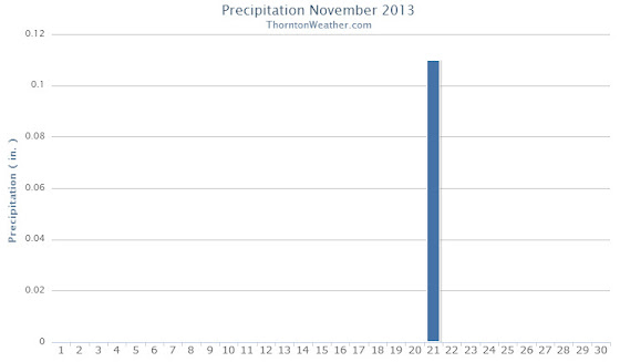
In 1984…a rare November thunderstorm produced west winds gusting to 31 mph…but only 0.04 inch of rain at Stapleton International Airport.
In 1996…high winds gusting from 80 to 100 mph were recorded at Wondervu in the foothills southwest of Boulder. West northwest winds gusted to 32 mph at Denver International Airport.
In 2006…the temperature in Denver climbed to a high of 80 degrees. This was the first time the temperature had ever exceeded the 70’s in November since records began in 1872. This new all-time record maximum temperature for the month of November was also a new daily record and the highest temperature ever recorded so late in the season.
From the 8th to the 9th:
In 1897…west winds were sustained to 45 mph with gusts as high as 50 mph in the city.
In 1919…post-frontal heavy snowfall totaled 8.4 inches over downtown Denver. Most of the snow…6.6 inches…fell on the 9th. North winds were sustained to 26 mph with gusts to 30 mph on the 8th.
In 1950…a major winter storm dumped 10.4 inches of snow at Stapleton Airport with the most snow…7.8 inches…falling on the 8th. East winds gusted to 31 mph at Stapleton Airport on the 8th. Snowfall totaled 8.2 inches in downtown Denver.
In 1958…strong winds caused some damage in Boulder. West- northwest winds gusted to 40 mph at Stapleton Airport on the 8th.
In 1975…heavy snowfall hit metro Denver. Snowfall at Stapleton International Airport totaled 8.0 inches and east winds gusted to 21 mph. Power outages caused by the storm affected over 10 thousand people in metro Denver. In the foothills west of Denver…10 to 15 inches of snow fell. The storm produced the greatest 24-hour precipitation…1.29 inches…ever recorded during the month of November in the city.
In 1983…metro Denver received 4 to 8 inches of snow with the heaviest amounts near the foothills. It was the first measurable snow of the season in Denver. Only 1.8 inches of snow fell at Stapleton International Airport where north winds gusted to 20 mph.
In 1989…strong winds hit the Front Range. On the 9th…the wooden frame of a house under construction in Boulder was blown down. The previous evening a power outage blackened Nederland. Wind gusts to 95 mph were recorded 4 miles south of Rollinsville with 97 mph on fritz peak near that town. At Stapleton International Airport…northwest winds gusted to 45 mph on the 8th and to 38 mph on the 9th.
In 1998…another upslope snow event developed in the Front Range foothills. The heaviest snowfall occurred in west central Jefferson County where 14 inches were measured 8 miles west of conifer. Other snowfall totals included: 10 inches at evergreen and 9 miles northwest of Bergen Park; 9 inches at Genesee…Nederland…and near the Chief Hosa exit on I-70; and 8 inches in Coal Creek Canyon. On the 9th…snowfall was 2.6 inches at the site of the former Stapleton International Airport. North-northeast winds gusted to 30 mph at Denver International Airport on the 9th.
From the 8th to the 10th:
In 1985…Indian summer came to an abrupt end when a winter storm dumped 10 to 18 inches of snow in the Front Range foothills and 6 to 10 inches across metro Denver…snarling traffic and causing flight delays of up to 3 hours at Stapleton International Airport. The temperature plunged from a high of 66 degrees on the 8th to a low of only 13 degrees on the 9th…after the passage of a vigorous cold front with northeast winds gusting to 32 mph. The temperature climbed to only 19 degrees on the 10th…setting a record low maximum for the date. Snowfall totaled 7.3 inches at Stapleton International Airport with most of the snow…7.1 inches…falling on the 9th.
On the 9th:
In 1939…a trace of snow fell over downtown Denver. This snow…along with a trace of snow on the 2nd…was the only snow of the month…ranking it…along with other months…the second least snowiest November on record. Precipitation of 0.01 inch was the only precipitation of the month…making this the second driest November on record.
In 1944…the first killing frost of the season occurred in the city when the low temperature dipped to 35 degrees. This is the latest date for a killing frost ever recorded in Denver.
In 1946…heavy snowfall totaled 7.7 inches over downtown Denver. This was the second heavy snowfall in less than a week. Northwest winds were sustained to 26 mph.
In 1995…strong downslope winds gusted between 50 and 57 mph at Erie and Boulder. West wind gusts to 44 mph were recorded at Denver International Airport.
In 2014…a record high min of 45 degrees… Broke the previous record of 43 degrees set in 1934…and preceded several days of record cold temperatures from the 11th through the 13th.
Continue reading November 8 to November 14: This week in Denver weather history
 The weather during the month of November in Denver metro area can offer just about anything. While it is normally a quiet month, it can be prone to extremes.
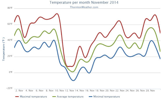


")