Some weeks on the Denver weather history calendar just seem to be busier than others and such is the case with this one. Numerous significant snow and wind events dominate the period around Thanksgiving as well as some examples of extreme cold.
From the National Weather Service:
21-25
In 1952…snowfall of 6.2 inches was measured at Stapleton Airport where northeast winds gusted to 17 mph on the 21st.
23-24
In 1992…a pre-Thanksgiving blizzard belted metro Denver. Gusty north to northeast winds at 30 to 40 mph caused near-whiteout conditions as visibilities were often below 1/4 mile. The strong winds drove snow into drifts of more than 4 feet. Hundreds of holiday travelers were stranded when airlines canceled flights at Stapleton International Airport where snowfall totaled 7.6 inches and north winds gusted to 37 mph. Blizzard conditions began around mid- morning on the 23rd and ended by mid-afternoon…but heavy snow fell through the night. Snowfall totaled: 12 inches at Conifer…Morrison…and Wheat Ridge; 19 inches at Littleton; 16 inches at Castle Rock; 9 inches in Brighton; 8 inches in Aurora; and 6 inches in Parker.
In 1993…a moist upper level disturbance dumped heavy snow over most of Colorado. Snowfall amounts averaged 5 to 8 inches across metro Denver. Snowfall totaled 4.6 inches at Stapleton International Airport where northeast winds gusted to only 20 mph on the 23rd. The very cold air mass caused the temperature to dip to a record low of 8 degrees below zero on the 24th. The temperature that day climbed to only 9 degrees…also setting a record low maximum for the date.
24
In 1915…Chinook winds from the southwest sustained to 40 mph with gusts to 46 mph warmed the temperature to a high of 61 degrees. It was windy most of the day.
In 1949…the low temperature dipped to 56 degrees…the all-time record highest minimum temperature ever recorded during the month of November.
In 1960…violent wind gusts caused some damage in Boulder. West winds gusted to only 22 mph at Stapleton Airport.
In 1980…a snow storm brought 3 to 6 inches of snow across metro Denver. At Stapleton International Airport…only 2.1 inches of snow fell.
In 1989…high winds were recorded in Boulder with a gust to 64 mph. West winds gusted to only 24 mph at Stapleton International Airport.
24-25
In 1908…heavy snowfall totaled 7.0 inches over downtown Denver overnight. North winds were sustained to 15 mph.
In 1930 strong winds raked the Front Range eastern foothills. Winds gusted to 40 mph at Valmont just east of Boulder where minor damage occurred.
In 1970…strong Chinook winds warmed Boulder. At the National Center for Atmospheric Research in Boulder…wind gusts reached 97 mph…while in downtown Boulder winds peaked to 69 mph. Some minor damage occurred. Northwest winds gusted to 39 mph at Stapleton International Airport…and the high temperature warmed to 76 degrees on the 25th…setting a new record maximum for the date.
25
In 1877…northwest winds were sustained to 50 mph.
In 1902…northwest winds were sustained to 45 mph with gusts to 48 mph. The strong apparent bora winds warmed the temperature to a high of only 45 degrees.
In 1943…snowfall of 4.0 inches was the only measurable snow of the month. North winds were sustained to 17 mph.
In 1958…strong pre-frontal Chinook winds struck Boulder and the eastern foothills. A wind gust to 100 mph was recorded northwest of Denver. A gust to 88 mph occurred at Rocky Flats south of Boulder. The windstorm caused considerable structural damage to residential sections of north metro Denver.
In 1959…strong winds raked the eastern foothills including Boulder and Eldorado Springs. Wind gusts to 100 mph were estimated at the Matterhorn restaurant located atop Rocky Flats south of Boulder.
In 1993…a wind gust to 99 mph was recorded atop Squaw Mountain near Idaho Springs.
In 1998…strong winds developed over portions of the Front Range foothills for a brief time following the passage of a weak upper level disturbance. A wind gust to 71 mph was measured atop Blue Mountain near Coal Creek Canyon.
In 1999…strong Chinook winds developed in and near the foothills. Peak wind reports included 100 mph at the Eldora Ski Resort and 77 mph at the National Center for Atmospheric Research mesa lab above Boulder. West winds gusted to 38 mph at Denver International Airport.
In 2010…high winds developed in the foothills of Boulder County. A gust to 75 mph occurred 5 miles northwest of Boulder with a gust to 72 mph at the National Center for Atmospheric Research mesa lab above Boulder. West winds gusted to 24 mph at Denver International Airport.
25-26
In 1887…snowfall totaled 2.9 inches in the city. This was the only measurable snow of the month. Northeast winds were sustained to 18 mph on the 26th when the temperature dipped to 12 degrees below zero.
In 1959…a sharp cold front produced a northwest wind gust to 51 mph…followed by snow and falling temperatures from a high of 60 degrees to a low of 23 degrees at midnight on the 25th. Snowfall totaled 4.4 inches at Stapleton Airport before ending early on the 26th.
In 1972…winds gusted to 104 mph at the Rocky Flats plant south of Boulder. Gusts to 70 mph were recorded at the National Bureau of Standards in Boulder…while in downtown Boulder winds peaked to 68 mph. Some damage was reported. Northwest winds gusted to 47 mph at Stapleton International Airport on the 26th.
In 1984…blowing snow closed I-70 east of Denver…stranding over a thousand travelers in Limon. Denver received only 2.3 inches of snowfall. North winds gusted to 31 mph at Stapleton International Airport.
In 1999…strong Chinook winds redeveloped overnight in and near the foothills. Peak wind gusts included 72 mph atop Blue Mountain near Wondervu and at the National Center for Atmospheric Research mesa lab above Boulder.
25-27
In 1978…heavy snowfall of 6.0 inches was measured at Stapleton International Airport where north winds gusted to 20 mph. Most of the snow…4.8 inches…fell on the 25th. The greatest amount of snow measured on the ground was 5 inches due to settling and melting.
Powerful, damaging winds, heavy snow and the first official weather observation in the Mile High City highlight this week in Denver weather history.
From the National Weather Service:
14-18
In 1964…the first measurable snowfall of the season totaled 6.0 inches at Stapleton International Airport where northeast winds gusted to 32 mph on the 14th. Most of the snow…4.2 inches…fell on the 14th. This was the only measurable snow of the month.
15-17
In 1991…a strong winter storm dumped heavy snow over metro Denver. Snowfall amounts totaled 15 inches at Castle Rock and Conifer…14 inches at Morrison and Parker…12 inches in southeast Aurora…and 11.6 inches at Stapleton International Airport. Winds were light with the storm.
16-17
In 2010…the combination of heavy snow and strong winds produced dangerous driving conditions in the high country. Blizzard conditions forced the closure of U.S. Highway 6 at Loveland pass and U.S. Highway 40 at Berthoud Pass. Blowing and drifting snow forced the closure of a 65-mile stretch of Interstate 70…west of Idaho Springs. Peak wind gusts included: 68 mph atop Niwot Ridge…55 mph near Blackhawk and Gunsight…and 52 mph at Berthoud Pass. Storm totals in the ski areas west of Denver ranged from 12 to 21 inches. Northwest winds gusted to 55 mph at Denver International Airport on the 16th.
In 2010…the combination of snow and strong winds produced dangerous driving conditions in the mountains west of Denver. Near blizzard conditions forced the closure of U.S. Highway 6 at Loveland pass and U.S. Highway 40 at Berthoud Pass. Blowing and drifting snow closed a 65-mile stretch of interstate 70…between Idaho Springs and Vail Pass. Peak wind gusts included: 68 mph atop Niwot Ridge…62 mph at Loveland Pass…55 mph near Blackhawk and 52 mph at Berthoud Pass.
16-18
In 1921…heavy snowfall totaled 6.5 inches over downtown Denver. This was the only measurable snow of the month. East winds were sustained to 14 mph on the 17th.
17
In 1948…a dry vigorous cold front accompanied by north winds gusting to 60 mph produced extensive blowing dust…which briefly reduced the visibility to 1/2 mile at Stapleton Airport.
In 1993…a wind gust to 70 mph was recorded atop Squaw Mountain near Idaho Springs.
In 1994…winds gusted to 66 mph in Boulder and to 63 mph on Rocky Flats south of Boulder. West winds gusted to 49 mph at Stapleton International Airport.
In 2000…snow fell in the foothills west of Denver…mainly south of the I-70 corridor. Snowfall totals included: 8.5 inches…7 miles south of tiny town; 6 inches at Genesee; and 5 inches…11 miles southwest of Morrison. Only a trace of snow was recorded at the site of the former Stapleton International Airport.
In 2016…bands of moderate to heavy snow fell along the Interstate 70 Corridor as strong fast moving storm system moved across Colorado. Wet roads quickly became icy and snowpacked. A 20-vehicle crash involving semis kept both directions of I-70 closed near Evergreen for a couple of hours. Storm totals included: 11.5 inches…4.5 miles south-southeast of Idaho Springs; 8 inches…5 miles west of Evergreen; 7.5 inches near Conifer…with 4 to 7 inches elsewhere. At Denver International Airport…1.7 inches of snowfall was observed.
17-18
In 1869…the heaviest wind storm in 5 or 6 years raked the eastern foothills including Boulder…Denver…Georgetown… And Golden. Some hundreds of dollars in damage occurred in Boulder.
18
In 1872…fresh west winds contributed to the relative humidity dipping to zero at 2:43 pm. The maximum temperature was 54 degrees.
In 1907…heavy snowfall totaled 6.0 inches over downtown Denver. Snow fell all day. North winds were sustained to 19 mph.
In 1915…northwest winds were sustained to 42 mph with gusts as high as 48 mph. It was windy most of the day.
In 1996…high winds struck the foothills west of Denver. Wind gusts ranged from 70 to 75 mph. A few power lines were downed…but no major outages were reported.
In 1998…strong downslope winds developed during the morning. Wind gusts reached a peak of 72 mph at Jefferson County Airport near Broomfield. West winds gusted to 41 mph at Denver International Airport.
In 1999…high winds developed in and near the Front Range foothills. The strong winds downed power lines…which sparked several small brush fires. In Broomfield… Scaffolding was damaged at the Wadsworth Recreation Center…while flying rocks broke several windows at a local bank building. Peak wind gusts included: 91 mph atop Blue Mountain near Wondervu…88 mph atop the Gamow Tower on the University of Colorado campus in Boulder… 83 mph at Jefferson County Airport…81 mph at the National Center for Atmospheric Research mesa lab above Boulder…and 80 mph at Wondervu. West-northwest winds gusted to 48 mph at Denver International Airport.
18-19
In 1975…snowfall totaled only 5.5 inches and north winds gusted to 35 mph causing some blowing snow at Stapleton International Airport…while a major blizzard struck southeastern Colorado.
In 1985…4 to 7 inches of snow fell across metro Denver. Snowfall totaled 4.4 inches at Stapleton International Airport where north winds gusted to 23 mph.
In 1991…another strong winter storm produced heavy snow over metro Denver. Snowfall totaled 9.5 inches at Stapleton International Airport with 9 inches at Parker… And 8 inches in southeast Denver…Morrison…and Wheat Ridge. This second storm brought the 5 day (15th-19th) snowfall total at Stapleton International Airport to 21.1 inches. The greatest depth of snow on the ground was 13 inches on the morning of the 19th. The adverse effects of the two storms were diminished by the lack of significant winds.
Wintry weather is not unusual this time of year but as our look back at this week in Denver weather history shows, high winds can be just as common and oftentimes more damaging.
From the National Weather Service:
8-10
In 1985…Indian summer came to an abrupt end when a winter storm dumped 10 to 18 inches of snow in the Front Range foothills and 6 to 10 inches across metro Denver…snarling traffic and causing flight delays of up to 3 hours at Stapleton International Airport. The temperature plunged from a high of 66 degrees on the 8th to a low of only 13 degrees on the 9th…after the passage of a vigorous cold front with northeast winds gusting to 32 mph. The temperature climbed to only 19 degrees on the 10th…setting a record low maximum for the date. Snowfall totaled 7.3 inches at Stapleton International Airport with most of the snow…7.1 inches…falling on the 9th.
10
In 1897…west Chinook winds sustained to 51 mph with gusts to 60 mph warmed the temperature to a high of 64 degrees.
In 1915…southwest winds were sustained to 41 mph with gusts as high as 44 mph.
In 1955…strong winds raked the eastern foothills. A wind gust to 80 mph was recorded atop Rocky Flats south of Boulder where some damage occurred.
In 1995…snowfall totaled 6 to 9 inches in the foothills west of Denver…while only 2.2 inches of snow fell at the site of the former Stapleton International Airport. North-northeast winds gusted to 31 mph at Denver International Airport.
In 1998…strong bora winds gusting from 70 to 92 mph coupled with blowing snow created whiteout and slick black ice conditions at the base of the foothills west of Denver. State Highway 93 between Golden and Boulder and C-470… Near the Morrison interchange were closed for several hours due to multiple car accidents. Dozens of motorists were stranded until weather conditions improved. A small motor home was a total loss when it caught fire after being blown on its side by strong crosswinds. A man was injured when he was blown off a vehicle while attempting to rescue the occupants. Wind gusts included: 92 mph atop Blue Mountain near Coal Creek Canyon…83 mph atop Fritz Peak near Rollinsville…and 77 mph at Jefferson County Airport near Broomfield. West winds gusted to 36 mph at Denver International Airport.
In 2000…freezing drizzle was widespread across northeastern Colorado with the heaviest amounts near the foothills in the evening. The freezing drizzle made many highways icy and slick…which contributed to a number of traffic accidents. Some highways across metro Denver were closed at times…including portions of State Highway 119 between Boulder and Longmont and U.S. 36 between Westminster and Boulder. State Highway 93 between Boulder and Golden atop Rocky Flats became nearly impassable due to a coating of ice by late evening.
10-11
In 1911…a strong cold front produced snow and a cold wave. The temperature dropped 68 degrees from a high of 66 degrees at 12:40 pm on the 10th to a low of 2 degrees below zero at 7:15 am on the 11th. The low temperature of 23 degrees at midnight on the 10th was also the high temperature on the 11th. Northeast winds were sustained to 42 mph with gusts to 51 mph. Snowfall was only 2.5 inches.
In 1982…up to 4 inches of snow fell over the higher terrain between Denver and Colorado springs. Winds gusted to 50 mph along the foothills. Rainfall totaled 0.27 inch with only 0.1 inch of snow on the 11th at Stapleton International Airport where north winds gusted to 39 mph. Dense fog with visibilities as low as zero persisted all day on the 10th.
10-14
In 2014…an Arctic cold front on the 10th…associated with a strong storm system over the northern Rockies blasted into northeast Colorado. The temperature in Denver plummeted from the high of 64 degrees at 4:37 pm to 34 degrees by 5:53 pm. The temperatures continued to fall and dropped into the teens by early evening. The Arctic airmass remained entrenched over the region through the morning of the 14th…with the high temperatures failing to reach the teens from the 11th through the 13th. This was the first time since records have been taken in Denver…dating back to 1872…that there were three consecutive days with the maximum temperatures remained below 20 degrees in the month of November. In addition to the frigid temperatures…0.1 inch of snowfall was observed on 11th at Denver International Airport…which marked the first measureable snowfall for the season. An additional 2.2 inches of snowfall was measured on the 12th. Several temperature records were broken. A record low max of 16 degrees on the 11th broke the previous record of 19 set back in 1916. A record low max of 6 degrees on the 12th broke the previous record of 9 degrees…also set in 1916. The record low of -13 on the 12th…shattered the previous record of -4 degrees set back in 1872. Even more impressive…the record low of -14 degrees on the 13th broke the previous record of -3 degrees set back in 1916. The sudden drop in temperatures on the 10th…followed by several days of sub-freezing temperatures chilled trees to the core. The record drop in temperatures…preceded by mild fall temperatures…damaged or killed scores of trees across the Urban Corridor and Northeast Plains. At the time…the trees were not finished with the hardening process that enables them to withstand winter weather. Many were instantly flash-frozen…and some would not show signs of damage until spring of 2015. Of the 2.2 million trees in the city of Denver alone…tens of thousands were killed from the November frost. Denver estimated a citywide loss of more than 10 million dollars.
11
In 1901…a trace of rain fell in the morning…and a trace of snow fell in the afternoon. This was the only snowfall and precipitation for the month…ranking it the driest November on record…along with November of 1899 and 1949. The month also ranks as the second least snowiest November…along with Novembers in other years.
In 1903…northwest winds sustained to 45 mph with gusts to 56 mph warmed the temperature to a high of 56 degrees.
In 1912…rain changed to snow…which became heavy…and totaled 6.5 inches over downtown Denver. Precipitation was 1.02 inches…the greatest calendar day precipitation ever recorded in November. Northeast winds were sustained to 27 mph with gusts to 29 mph.
In 1919…light snow fell from an apparent clear sky during the early afternoon. The first snow was observed at about 12:40 pm and continued at least 30 minutes before clouds could be seen forming…followed by the sky becoming totally cloudy. During this time the temperature fell from 50 degrees at noon to only 18 degrees at 100 pm and plunged to 6 degrees at 5:45 pm. A low temperature of 2 degrees was recorded overnight. Northeast winds were sustained to 33 mph with gusts to 36 mph between noon and 1:00 pm behind an apparent arctic cold front. Snowfall was only 0.1 inch.
In 1949…north winds gusted to 50 mph at Stapleton Airport. A trace of rain fell. Another trace of rain on the 15th was the only precipitation of the month…making the month one of the driest Novembers on record and the least snowiest with no snow. This was the first November since 1882 without snow.
In 1959…strong northwest winds struck Boulder and the foothills causing some damage. West winds gusted to 37 mph at Stapleton Airport.
In 1995…strong downslope winds gusting to 84 mph blew out a few car windows in Boulder County. Winds gusted to 69 mph at Golden…Lakewood…and Table Mesa in Boulder. West-northwest winds gusted to 43 mph at Denver International Airport.
In 2000…heavy snow occurred in the foothills southwest of Denver and over monument ridge south of Denver. Snowfall totals included: 6.5 inches near Parker… 6 inches near Bergen Park…5 inches at Genesee and near Sedalia…and 4 inches at Coal Creek Canyon and St. Mary’s glacier. Snowfall totaled 1.6 inches at the site of the former Stapleton International Airport.
In 2003…strong downslope winds developed along the Front Range. Peak wind reports included 91 mph atop Blue Mountain near Wondervu and 75 mph in Boulder. Damaging winds downed power lines in Boulder County. North of Golden…a semi-truck was blown over by the winds near the intersection of State Highways 72 and 93 atop Rocky Flats. At the same location…blowing rocks shattered several car windows at an RTD Park and Ride. West winds gusted to 40 mph at Denver International Airport.
Heavy snow and damaging winds, extreme conditions typical this time of year, make repeated appearances in our look back at this week in Denver weather history.
From the National Weather Service:
2-3
In 1974…heavy snowfall totaled 6.1 inches at Stapleton International Airport where north winds gusted to 23 mph on the 3rd. Most of the snow fell on the 3rd. Maximum snow depth on the ground was 5 inches.
In 1990…a winter storm dumped 3 to 8 inches of heavy wet snow across metro Denver. In the foothills snow amounts ranged from 4 to 10 inches. Slushy snow and ice-covered roads snarled traffic. The snow…ice…and poor visibilities were blamed for numerous traffic accidents. Low clouds… Fog…and snow delayed air traffic at Stapleton International Airport for at least 90 minutes on the afternoon of the 2nd. Snowfall totaled 5.4 inches at Stapleton International Airport where north winds gusted to 21 mph.
In 2018…a powerful and moist Pacific jet stream brought a period of moderate to heavy snow and blowing snow to the mountains west of Denver with up to a foot of snow. A strong gust front generated from dissipating showers near the foothills of southeast Larimer and eastern Boulder counties pushed across the I-25 corridor and adjacent plains. As the gust front swept across Denver International Airport…a peak wind gust to 58 mph was observed from the west-northwest.
2-5
In 1946…a major snow storm dumped 30.4 inches of heavy snowfall downtown and 31.0 inches at Stapleton Airport. The winter storm closed schools and disrupted all forms of transportation in the city. The greatest depth of snow on the ground was 28 inches at the airport. The duration of the snowfall…from 4:22 am on the 2nd to 3:08 am on the 5th… A total of 70 hours and 46 minutes…is the second longest period of continuous precipitation on record and the second heaviest snowfall of record at the time in Denver. The 17.7 inches of snowfall on the 2nd and 3rd was the greatest 24- hour snowfall ever recorded during the month of November. Buses and street cars had a difficult time…and many cars were abandoned along roadsides and streets for several days. Secondary roads in rural areas were blocked for 2 to 3 weeks. Several buildings in the city collapsed or were damaged from the weight of the heavy snow. Football games were canceled. Livestock losses were high over eastern Colorado. The precipitation from this storm alone exceeded the greatest amount ever recorded in Denver during the entire month of November previously. The precipitation recorded downtown was 2.03 inches…and the previous record for the entire month of November was 1.95 inches in 1922. North winds were sustained to 26 mph on the 2nd.
3
In 1940…the longest period without snow…200 days…ended on this date with the first snow of the season…a trace…on November 4…1940. The last snow of the previous season… Also a trace…occurred on April 17…1940.
In 1959…a rare thunderstorm in November occurred around sunrise. Rainfall measured only 0.02 inch at Stapleton Airport.
In 1993…periodic high winds buffeted the foothills west of Denver. Wind gusts to 90 mph were recorded at Rollinsville in the foothills southwest of Boulder…while gusts to 85 mph were observed atop Squaw Mountain near Idaho Springs. West winds gusted to 37 mph at Stapleton International Airport.
In 1996…a rare November thunderstorm during the early evening produced 0.10 inch of rain at Denver International Airport and only 0.06 inch of rain at the site of the former Stapleton International Airport.
In 2005…strong winds developed over the urban corridor. While the damaging winds were in the Fort Collins area… High winds also developed to the south of Denver in Douglas County. Peak wind reports included 70 mph at Franktown…65 mph in Castle Rock…and 61 mph in Sedalia. West winds gusting as high as 47 mph warmed the temperature to a high of 69 degrees at Denver International Airport. Winds were strong and gusty for most of the daytime hours across metro Denver.
3-4
In 1994…a fast moving snow storm dumped 8 to 9 inches of snow on Boulder…Broomfield…and Lafayette. Snowfall totaled only 1.8 inches at Stapleton International Airport where on the 3rd east winds gusted to 20 mph and some freezing drizzle fell.
4
In 1940…a trace of snow fell in downtown Denver. This marked the start of the shortest snow season on record… 167 days…through April 19…1941…when 0.4 inch of snow fell.
In 1959…high winds caused damage in many areas of the eastern plains. In Denver…winds averaged 40 mph with gusts to 70 mph. Some damage was reported to utility lines…signs…and vehicles. Northeast winds were sustained to 30 mph at Stapleton Airport.
In 2017…strong winds developed over the Palmer Divide. Peak wind gusts included 66 and 61 mph near Monument.
4-5
In 1933…the first measurable snow of the season totaled only 2.5 inches. This was the only measurable snow of the month. Northwest winds were sustained to 27 mph on the 4th.
In 1951…heavy snowfall of 5.7 inches was measured at Stapleton Airport where northwest winds gusted to 32 mph.
Our look back this week in Denver weather history highlights why being prepared for winter weather is so crucial. From massive winter storms to damaging wind and deadly exposure to the elements, we have seen each in the past.
From the National Weather Service:
25-27
In 1897…a major storm dumped 13.5 inches of snowfall over downtown Denver. Rain changed to snow during the evening of the 25th and continued through mid-morning of the 27th. Most of the snow…12.0 inches…fell on the 26th when north winds were sustained to 36 mph and gusts were as high as 46 mph. Temperatures during the storm were in the 20’s and lower 30’s. Precipitation (rain and melted snow) totaled 1.21 inches.
In 2021…the minimum temperature at Denver International Airport dropped into the single digits for three consecutive mornings: 8 degrees…4 degrees and 8 degrees respectively.
26-27
In 1971…strong winds raked Boulder. At the National Bureau of Standards wind gusts to 62 mph were recorded…while in downtown Boulder winds peaked to 48 mph. At Stapleton International Airport…northwest winds gusted to 38 mph on the 26th and north winds gusted to 36 mph on the 27th.
In 1976…the first measurable snow of the season turned into a major storm. Traffic was halted for several hours on highways to the west of Denver where 8 to 12 inches of snow fell in the foothills. Snowfall totaled 7.2 inches at Stapleton International Airport where north winds gusted to 30 mph. Most of the snow…6.3 inches…fell all day on the 26th. The greatest snow depth on the ground was 5 inches on the morning of the 27th.
27
In 1980…the first snowfall of the season totaled only 1.5 inches with 0.10 inch of moisture at Stapleton International Airport where the maximum snow depth on the ground was only 1 inch due to melting. This was the only measurable precipitation of the month…making it the driest October since 1962 when only 0.03 inch of precipitation was measured.
In 1994…wind gusts to 70 mph were recorded atop Squaw Mountain…5 miles south of Idaho Springs…and at Rollinsville in the foothills southwest of Boulder. Northwest winds gusted to 28 mph at Stapleton International Airport.
27-28
In 1874…strong west winds in Boulder along with a reported tornado produced 150 dollars in damage.
In 1913…a strong cold front produced sustained northeast winds to 35 mph with gusts as high as 38 mph on the 27th. Overnight snowfall totaled 5.8 inches. Temperatures plunged to a low of 17 degrees on the morning of the 28th after a high of 60 degrees on the 27th.
27-30
In 2009…a powerful early season storm brought heavy snow to the Front Range. The combination of a deep northeasterly upslope flow coupled with abundant moisture and lift with the developing storm system produced an extended period of moderate to heavy snowfall. The heavy wet snow accumulated on trees and resulted in broken branches and scattered electrical outages. Interstates 70 and 76 were closed east of Denver. Numerous other roads and highways were shut down. The Red Cross set up numerous emergency shelters for stranded travelers. The blowing snow at Denver International Airport forced the cancellation of hundreds of flights. Schools were also closed. In the foothills storm totals included: 46 inches… 3 miles southeast of Pinecliffe; 42 inches…3 miles southwest of Conifer; 34 inches…3 miles north of Blackhawk; 30 inches at Aspen Springs and near Evergreen… 23 inches at Roxborough Park…and 20 inches…3 miles south-southeast of Morrison. Across the urban corridor storm totals included: 25 inches in Highlands Ranch; 21.5 inches near Louisville…20.5 inches in Broomfield… 20 inches at Lafayette…17.5 inches in Boulder…17 inches in Westminster…16.5 inches in Erie; 15.5 inches in Arvada and 5 miles west-northwest of Littleton…15 inches in Littleton…14 inches in Englewood…13.5 inches in Lakewood and 6 miles north of Thornton; 13.3 inches at Denver International Airport…11 inches…4 miles south of Denver; 10.5 inches…2 miles north of cherry hills village and Niwot.
28
In 1917…post-frontal snowfall totaled 6.5 inches in the city. North winds sustained to 30 mph with gusts to 33 mph caused the temperature to plunge from a high of 58 degrees to a low of 9 degrees by midnight.
In 1967…winds gusted to 65 mph in downtown Boulder…causing minor damage. South winds gusted to 32 mph at Stapleton International Airport.
In 1991…the first major snow of the season hit metro Denver as a cold arctic air mass moved over the area. Snowfall amounts across northeast Colorado ranged from 3 to 10 inches with 4.4 inches of snowfall recorded at Stapleton International Airport where north winds gusted to 22 mph. The low temperature dipped to 13 degrees.
In 1993…high winds buffeted the Front Range foothills. A wind gust to 83 mph was recorded atop Squaw Mountain…35 miles west of Denver…and a gust to 76 mph occurred near Rollinsville southwest of Boulder.
28-29
In 1993…an upper level disturbance combined with a moist upslope flow to bring heavy snow to portions of metro Denver. Snowfall amounts ranged from 5.4 inches at Stapleton International Airport to 14 inches in Boulder. New snowfall totaled 8 inches at Gross Reservoir in the foothills 5 miles southwest of Boulder. On the 28th…north winds gusted to 30 mph at Stapleton International Airport where the temperature climbed to only 25 degrees on the 29th…equaling the record low maximum for the date.
28-30
In 1971…a vigorous cold front plunged temperatures from a high of 70 degrees on the 27th to record low levels on the 29th and 30th. Snowfall totaled 3.1 inches at Stapleton International Airport where north winds gusted to 23 mph. Some freezing drizzle also fell on the 28th. Record daily low maximum temperatures of 32 degrees on the 28th and 25 degrees on the 29th were established along with a daily record minimum of 13 degrees on the 30th.
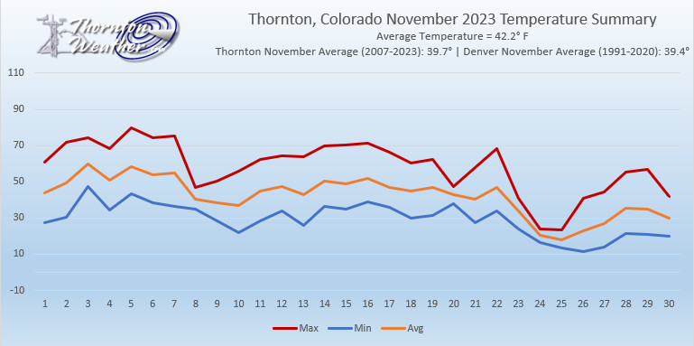
Thornton, Colorado’s November 2023 Temperature Summary. (ThorntonWeather.com)
For the second month in the row, Thornton saw a period of temperatures above normal and precipitation below normal. Were it not for a cold snap and snow to end the month, it would have been much worse.
Most of November saw a continuation of the mild, dry weather we saw in October. For the first three weeks, temperatures were largely above normal and precipitation was virtually non-existent. In fact, 19 out of the first 22 days of the month saw mercury readings above normal and a mere 0.02 inches had been recorded in the rain bucket and we had no snow.
Mother Nature finally changed course and chilled us out and brought our first snow of the month during the last week. We saw a few days with well below normal temperatures and 4.3 inches of snowfall were recorded over a two-day period.
Thornton’s average temperature for November 2023 came in at 42.2 degrees. This was well above our 17-year running average for November of 39.7 degrees. Temperatures ranged from a high of 79.8 degrees on the 5th down to a low of 11.7 degrees on the 26th.
Out at DIA where the Mile High City’s official measurements are taken, it was similarly warm. Denver had an overage temperature for the month of 43.2 degrees, again, well above their average of 39.4 degrees.
In terms of precipitation, Thornton saw a mere 0.20 inches of liquid precipitation during the month. This was less than half of the 0.47 inches running November average and tied for the third driest November of the past 17 years.
Denver recorded 0.18 inches out at the airport. Far below their long term November average of 0.64 inches.
Snow was below normal both here in Thornton and at DIA. Thornton recorded 4.3 inches, a good bit below the 5.7 inch November average of the past 17 years. Denver saw less than us with 2.9 inches, far below their long term November average of 7.3 inches.
Wind and big time snowstorms can visit the Mile High City this time of year and we see many such events in our look back at this week in Denver weather history. Probably most notable, the Blizzard of 1913, the Mile High City’s biggest snowstorm in history.
Stay up to date with Thornton’s weather: ‘Like’ us on Facebook and follow us on Twitter
From the National Weather Service:
1-5
In 1913…the 1st marked the start of the heaviest 5-day total snowfall in the city’s history. During this period snowfall totaled 45.7 inches. Starting on the 1st…snow fell intermittently for 3 days and accumulated a little over 8 inches. On the 4th and 5th…an additional 37.4 inches of snow fell. At Georgetown in the foothills west of Denver even more snow fell…86 inches over the 5 days with the most…63 inches…on the 4th. In Colorado…snowfall was heavy along the eastern slopes of the mountains from the Palmer Divide north. High winds during the storm caused heavy drifting…which blocked all transportation. Snow cover of an inch or more from the storm persisted for 60 consecutive days from the 1st through January 29…1914. Additional snowfall in December and January prolonged the number of days. This is the third longest period of snow cover on record in the city.
2-3
In 1955…snowfall totaled only 2.9 inches at Stapleton Airport. This was the only measurable snowfall of the month.
In 1973…post-frontal heavy snowfall totaled 7.6 inches at Stapleton International Airport where northeast winds gusting to 37 mph caused some blowing snow.
In 1990…strong downslope winds raked the eastern foothills and most of metro Denver. A wind gust to 87 mph was recorded at Rollinsville with wind gusts to 58 mph in Arvada and 55 mph in Lakewood. West winds gusted to 48 mph at Stapleton International Airport on the 2nd.
In 1997…heavy snow fell in the foothills. Conifer received 10 inches of new snow. Snowfall totaled only 2.4 inches at the site of the former Stapleton International Airport on the 1st…2nd…and 3rd. North winds gusted to 24 mph at Denver International Airport on the 2nd.
2-4
In 1909…post-frontal snowfall totaled 6.1 inches in downtown Denver. Most of the snow…5.9 inches…fell between 6:00 pm on the 2nd and 6:00 pm on the 3rd. North winds were sustained to 18 mph on both the 2nd and 3rd.
2-17
In 1939…more than 2 weeks of unseasonably warm weather made the month the 3rd warmest on record. Seven daily temperature records were set…including the all time record high temperature for the month of 79 degrees on the 5th. Daytime highs were balmy with 14 days in the 60’s and 70’s. Low temperatures dipped to freezing or below on only 5 days. The period was dry with only a trace of snow on the 12th.
3
In 1977…high winds continued in Boulder and were clocked from 74 to 90 mph…causing only minor damage. Northwest winds gusted to 33 mph at Stapleton International Airport where the strong Chinook winds warmed the temperature to a high of 63 degrees.
In 1985…wind gusts to 78 mph were clocked at Table Mesa in Boulder. Winds gusted to 70 mph at Echo Lake west of Denver.
In 2011…Another round of snow developed in and near the Front Range Foothills. The heaviest snowfall occurred in the foothills of Boulder and northern Jefferson Counties. Storm totals included: 13 inches…7 miles southwest of Boulder; 10.5 inches…4 miles east-northeast of Nederland; 10 inches at Genesee; 9.5 inches…4 miles west-northwest of Boulder; 9 inches at Gross Reservoir and 4 miles east of Pinecliffe. Around the Urban Corridor…storm totals ranged from 3 to 8 inches…heaviest in and around Boulder.
3-4
In 1968…strong Chinook winds in Boulder gusting to 52 mph downtown caused 7 thousand dollars in damage. Flying debris damaged cars…houses…and other property in Boulder. West winds gusted to 49 mph late on the 3rd and to 45 mph on the 4th at Stapleton International Airport where the temperature climbed to a high of 60 degrees on the 4th.
In 1970…strong winds whistled through Boulder. Sustained winds of 40 mph with gusts to 70 mph were recorded at the National Bureau of Standards in Boulder. Wind gusts to 50 mph occurred in downtown Denver. No damage was reported. On the 3rd…northwest winds gusted to 40 mph at Stapleton International Airport where the Chinook winds warmed the temperature to a high of 66 degrees on the 4th.
In 1999…heavy snow fell over the foothills and metro Denver. The heaviest snowfall occurred in the foothills south of I-70 and near the Palmer Divide. Snowfall totals included: 25 inches near Tiny Town; 18 inches at Conifer; 15 inches near Evergreen; 14 inches at Chief Hosa…8 miles west of Castle Rock…and near Blackhawk; 12 inches at Pine Junction and 8 miles south of Sedalia; 11 inches atop Floyd Hill and in Roxborough; and 10 inches at Castle Rock. Around metro Denver…snowfall totals included: 10 inches at Highlands Ranch…9 inches at Parker…and 8 inches in Aurora and Wheat Ridge. Elsewhere around the metro area…snowfall generally ranged from 3 to 5 inches. Only 3.2 inches of snow fell at the site of the former Stapleton International Airport. North winds gusted to 32 mph at Denver International Airport on the 3rd.
In 2007…high winds developed in and near the Front Range foothills. Peak wind reports included: 88 mph atop Niwot Ridge; 87 mph atop mines peak; 80 mph…3 miles southeast of Jamestown; 78 mph at Longmont; 74 mph at Table Mesa. A few power outages occurred in Longmont as broken branches downed power lines. Northwest winds gusted to 38 mph at Denver International Airport on the 4th.
In 2013…a storm system brought heavy snow to parts of the Front Range Foothills. Storm totals included: 12 inches…7 miles west-southwest of Evergreen; 10.5 inches…3 miles north of Bailey; 9.5 inches…3 miles west of Jamestown and 5 miles northeast of Ward; 9 inches in Bailey…8.5 inches… 3 miles north of Conifer. Continue reading December 3 to December 9: This week in Denver weather history→
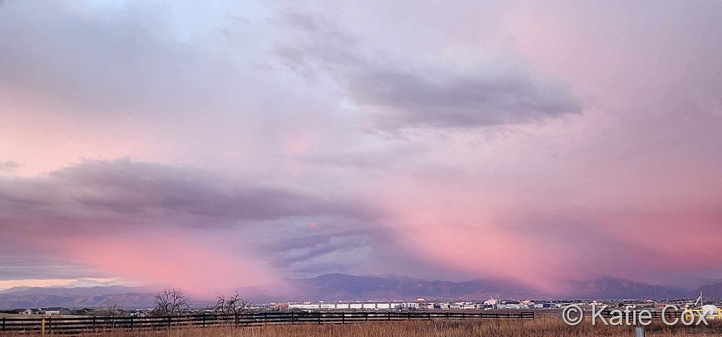
A stunner of a sunset in Thornton. (Michelle Jones)
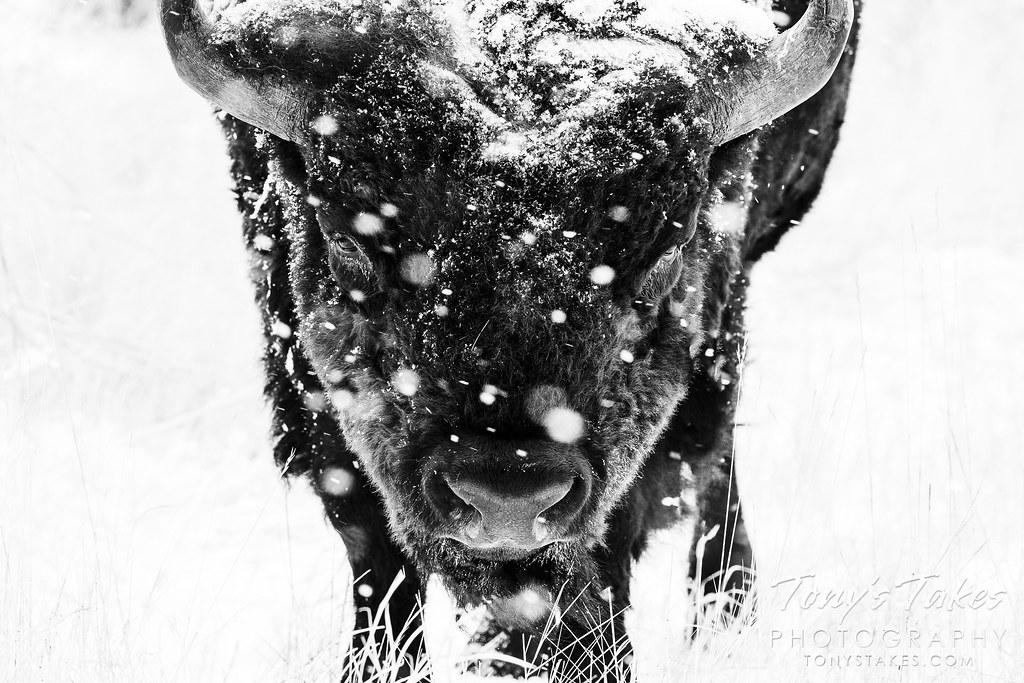
Typically November is a quiet weather month with plenty of nice, fall days but it can also turn wet with healthy doses of snow and moisture. The wide variety of conditions can create picturesque scenes ranging from blue skies and snow-capped mountains to a wintry wonderland in the metro area.
November is the second snowiest month of the year so winter conditions are not unusual. Typically though, these bouts of cold are short-lived and normal daytime conditions are pleasant.
Outdoor activities continue to be quite popular during the month. The cooling temperatures do oftentimes lead to an increase in wildlife activity.
All of the above help lead to a month in which a wide variety of scenes, flora and fauna can be captured.
Slideshow updated November 28, 2023
To learn more about how to send your photo to us for inclusion in the slideshow, see below the slideshow.
Showcasing images captured by ThorntonWeather.com readers as well as some of our own, our monthly slideshow covers the entire gamut of weather-related imagery.
Sunsets, sunrises, wildlife and of course every type of weather condition are vividly depicted in images captured from yours and our cameras.
What is missing in the slideshow above? Your photo!
Our monthly photo slideshow is going to feature images that we have taken but more importantly images that you have captured. The photos can be of anything even remotely weather-related.
Landscapes, current conditions, wildlife, pets, kids. Whimsical, newsy, artsy. Taken at the zoo, some other area attraction, a local park, a national park or your backyard. You name it, we want to see and share it!
Images can be taken in Thornton, Denver or anywhere across the extraordinary Centennial State. We’ll even take some from out of state if we can tie it to Colorado somehow.
We’ll keep the criteria very open to interpretation with just about any image eligible to be shown in our slideshows.
What do you win for having your image in our slideshow? We are just a ‘mom and pop’ outfit and make no money from our site so we really don’t have the means to provide prizes. However you will have our undying gratitude and the satisfaction that your images are shared on the most popular website in Thornton.
To share you images with us and get them included in the slideshow just email them to us or share them with ThorntonWeather.com on any of the various social media outlets. Links are provided below.
Cold, snow and wind are the dominant conditions we see in our look back at this week in Denver weather history. All three are common this time of year and extremes with those conditions seem to be unusually common as well.
Among the highlights are numerous high wind events that not only caused damage but also injury to unprepared residents. Significant snowfall also appears many times including a storm in 1983 that shut down the city for the Thanksgiving weekend and left snow on the ground for 63 days.
Stay up to date with Thornton’s weather: ‘Like’ us on Facebook and follow us on Twitter
From the National Weather Service:
25-26
In 1887…snowfall totaled 2.9 inches in the city. This was the only measurable snow of the month. Northeast winds were sustained to 18 mph on the 26th when the temperature dipped to 12 degrees below zero.
In 1959…a sharp cold front produced a northwest wind gust to 51 mph…followed by snow and falling temperatures from a high of 60 degrees to a low of 23 degrees at midnight on the 25th. Snowfall totaled 4.4 inches at Stapleton Airport before ending early on the 26th.
In 1972…winds gusted to 104 mph at the Rocky Flats plant south of Boulder. Gusts to 70 mph were recorded at the National Bureau of Standards in Boulder…while in downtown Boulder winds peaked to 68 mph. Some damage was reported. Northwest winds gusted to 47 mph at Stapleton International Airport on the 26th.
In 1984…blowing snow closed I-70 east of Denver…stranding over a thousand travelers in Limon. Denver received only 2.3 inches of snowfall. North winds gusted to 31 mph at Stapleton International Airport.
In 1999…strong Chinook winds redeveloped overnight in and near the foothills. Peak wind gusts included 72 mph atop Blue Mountain near Wondervu and at the National Center for Atmospheric Research mesa lab above Boulder.
25-27
In 1978…heavy snowfall of 6.0 inches was measured at Stapleton International Airport where north winds gusted to 20 mph. Most of the snow…4.8 inches…fell on the 25th. The greatest amount of snow measured on the ground was 5 inches due to settling and melting.
25-28
In 1952…the average coldest 4-day period in November in the previous 81 years of record occurred. Maximum temperatures of 19…15…21…and 25 degrees were recorded. Minimum temperatures were below zero each day with readings of 7 below…6 below…5 below…and 6 below.
25-29
In 1985…dense fog with visibilities as low as 1/8 mile occurred on five consecutive days at Stapleton International Airport. The fog was at times accompanied by light snow… Light freezing drizzle…or ice crystals. Fog occurred all day on both the 26th and 29th.
26
In 1873…west winds increased to a violent gale at 3:00 am and reached a maximum sustained velocity of 56 mph at 3:15 am. The winds continued with a velocity of not less than 40 mph until 6:00 am. Winds continued brisk for the remainder of the day. The strong winds caused damage to houses and buildings in the city. Temperatures were in the 50’s through early afternoon with a recorded high of 59 degrees. Winds also blew strongly in Boulder and caused 300 dollars in damage.
In 1911…post-frontal northeast winds were sustained to 43 mph with gusts as high as 52 mph. Snowfall was only 0.5 inch.
In 1965…post-frontal snowfall totaled 5.5 inches at Stapleton International Airport where strong west winds gusted to 39 mph during the afternoon.
In 1976…2 to 4 inches of snow with an arctic cold front produced near zero visibility at times in blowing snow… Causing multiple automobile accidents in metro Denver. Snowfall totaled 3.5 inches at Stapleton International Airport where north winds gusted to 39 mph. Temperatures hovered in the teens and lower 20’s most of the day dipping to 7 degrees by midnight.
In 1977 a strong wind storm raked metro Denver. High winds blew windows from office towers in Denver and Boulder. Thirteen people were injured in Boulder due to flying debris. Wind gusts to 119 mph were clocked on Davidson Mesa southeast of Boulder…with 109 mph in downtown Boulder. Six airplanes were damaged at Jefferson County Airport near Broomfield. Winds to 90 mph were reported in Lakewood. Glass was blown out of several vehicles in Wheat Ridge…and roofs were blown off 4 houses in Arvada. Several houses under construction collapsed across metro Denver. Winds to 75 mph were reported at the Denver Federal Center with 90 mph at Rocky Flats. West winds gusted to 51 mph at Stapleton International Airport. Total insured damage from the wind storm was 2.2 million dollars.
In 1987…a thanksgiving snowstorm brought 5 inches of snow to metro Denver and 6 inches to the foothills. At Stapleton International Airport…snowfall totaled 5.0 inches…north winds gusted to 22 mph…and temperatures hovered in the upper 20’s most of the day.
In 1991…strong winds were recorded in and near the eastern foothills. Winds at Rollinsville were clocked to 70 mph with 45 mph recorded in Boulder and 51 mph at the U.S. Atomic Energy Commission Rocky Flats plant. West winds gusted to only 28 mph at Stapleton International Airport.
26-27
In 1876…heavy snowfall totaled 9.0 inches over the city from 5:00 pm on the 26th through 5:00 p.m. on the 27th. Precipitation was 0.30 inch on the 25th and 0.60 inch on the 27th.
In 1919…an incursion of cold arctic air produced snowfall of 4.6 inches over downtown Denver. Temperatures dipped to 5 degrees below zero on the evening of the 26th and recovered to a high of only 1 degree below zero on the 27th…the all-time record low maximum for the month of November and the record for the date. Northwest winds were sustained to 25 mph with gusts to 26 mph on the 26th.
In 1923…snowfall of 2.0 inches was the only snow of the month. North winds were sustained to 22 mph on the 26th.
In 1972…heavy snowfall totaled 7.5 inches at Stapleton International Airport where north winds gusted to only 18 mph on the 27th.
In 1983…a Thanksgiving blizzard dumped 21.5 inches of snowfall in 37 hours with a maximum of 18 inches on the ground at Stapleton International Airport. The storm produced howling winds…which paralyzed Thanksgiving weekend transportation across all of eastern Colorado. On the 27th…Stapleton International Airport closed… Opening 24 hours later. Interstate highways were closed in all directions…but west…from Denver. At Stapleton International Airport…north winds gusted to 36 mph on the 26th and to 29 mph on the 27th. However…most wind speeds across metro Denver were 15 to 30 mph. Temperatures hovered in the teens and lower 20’s. Many stores and businesses closed. Several high school football games were postponed. Across metro Denver…snow depth varied from 15 inches in Commerce City to 28 inches near Chatfield Reservoir. Snow removal in Denver was estimated at 1.5 million dollars. Following the storm… An inch or more of snow remained on the ground for 63 consecutive days through January 27…1984. This is the longest period of continuous snow cover ever recorded in Denver.
In 1990…an early winter storm deposited 2 to 8 inches of wet snow across metro Denver. Snowfall totaled 3.4 inches at Stapleton International Airport where northeast winds gusted to 30 mph on the 26th.
In 1993…strong winds swept off the foothills across metro Denver. Sustained winds of 30 to 50 mph were common across the area. Wind gusts to 67 mph were recorded atop Squaw Mountain near Idaho Springs. West winds gusted to 36 mph at Stapleton International Airport on the 26th. The strong winds produced some blowing snow…reducing the visibility to less than one mile at times.
In 1995…snowfall totaled 3.7 inches at the former Stapleton International Airport site. The foothills west of Denver received 4 to 7 inches of snow. North-northeast winds gusted to 34 mph at Denver International Airport on the 26th.
27
In 1965…strong winds buffeted Boulder…causing 11 thousand dollars in damage. Wind gusts to 75 mph were recorded downtown. West winds gusted to 38 mph at Stapleton International Airport.
In 1994…winds gusted to 87 mph atop Squaw Mountain…5 miles south of Idaho Springs…and to 84 mph on Fritz Peak near Rollinsville in the foothills southwest of Boulder. Northwest winds gusted to 40 mph at Stapleton International Airport.
In 2017…The maximum temperature for Denver reached 81 degrees which was 34 degrees above the normal high of 47 degrees. This difference between the actual high and the normal high was the second largest ever recorded for Denver. The only larger difference occurred on Dec 5…1939 when Denver was 35 degrees above normal. It also established a new record for the latest 80 degree day for the calendar year in Denver… breaking the previous date by 11 days.
28
In 1884…a windstorm during the afternoon produced northwest sustained winds to 46 mph. Two wooden slats were blown out of the weather instrument shelter…and nearly all of the slats on the north and west sides were loosened.
In 1898…northwest winds were sustained to 50 mph with gusts as high as 80 mph.
In 1902…northwest winds were sustained to 40 mph with gusts to 48 mph. The strong apparent Bora winds warmed the temperature to a high of only 40 degrees.
In 1904…northwest winds sustained to 44 mph with gusts to 58 mph warmed the temperature to a high of 58 degrees.
In 1927…strong west winds occurred in Boulder…causing widespread minor damage. A wind gust to 65 mph was recorded at Valmont east of Boulder. The west winds possibly produced a cyclonic twist.
In 1928…heavy snowfall totaled 7.0 inches over downtown Denver.
In 1957…a vigorous cold front produced north-northeast wind gusts to 54 mph at Stapleton Airport. Light snow following the front totaled only 0.2 inch.
In 1970…strong Chinook winds reached 77 mph in downtown Boulder.
In 1978…wind gusts 60 to 90 mph were reported in and near the foothills.
In 1984…high winds of 60 to 80 mph occurred along the Front Range eastern foothills.
In Boulder…the high winds blew the roof off a service station. Several trees were felled… Damaging some cars. An elderly woman was injured when she was knocked down by a wind gust and blown 20 feet into some bushes. Northwest winds gusted to 36 mph at Stapleton International Airport.
In 1994…winds gusted to 72 mph in Boulder. No damage was reported. Northwest winds gusted to 35 mph at Stapleton International Airport.
28-29
In 1908…heavy snowfall overnight and for most of the day on the 29th totaled 12.5 inches. Precipitation was 1.09 inches. Northwest winds were sustained to 26 mph on the 29th.
In 1928…a major storm dumped 15.5 inches of snowfall on downtown Denver. North winds were sustained to 18 mph with gusts to 19 mph on the 28th.
In 1992…an upper level storm system moved across metro Denver…but left only a dusting of snow. Snowfall totaled only 1.6 inches at Stapleton International Airport where north winds gusted to 25 mph. Other snow amounts included: 8 inches at Conifer…6 inches at Lake Eldora…3 inches at Rollinsville and in southeast Denver.
In 1997…a storm system tracking across northern New Mexico produced strong north to northeast upslope flow against the eastern slopes of the Front Range and Palmer Ridge. Snowfall totals in Jefferson County included: 14 inches near Deckers; 12 inches at Castle Rock and Sedalia; 10 inches near Conifer…11 miles southwest of Morrison…and at Buffalo Creek. Elsewhere…snow accumulations were less. Snowfall totaled only 0.7 inch at the site of the former Stapleton International Airport on the 27th and 28th.
In 2004…heavy snow fell in the foothills and across metro Denver. In the foothills…snowfall totals included: 13 inches at Roxborough State Park and Eldorado Springs… 11.5 inches near Conifer…11.0 inches near Nederland…and 10 inches near Indian Hills. Across metro Denver snowfall totaled 14 inches near Sedalia…9 inches near Louisville… 8 inches at Ralston Reservoir…and 5.1 inches in the Stapleton area of Denver. Northeast winds gusted to 28 mph at Denver International Airport on the 28th.
In 2006…a slow moving storm system brought heavy snow to the mountains and to the eastern foothills where snowfall ranged from 8 to 18 inches. Some of the more impressive snow totals included: 18 inches at Genesee…17.5 inches near Boulder…17 inches at Aspen Springs…16.5 inches 10 miles northwest of Golden…15 inches at Eldorado Springs… 14.5 inches in Idaho Springs and near Jamestown…12 inches in grant and near Indian Hills…11.5 inches near Blackhawk… 11 inches at Gross Reservoir and Eldora…and 10.5 inches in Conifer. Across metro Denver…storm total snowfall generally ranged from 5 to 9 inches with the heaviest amounts near the foothills in Boulder and Jefferson counties. The most impressive totals included: 15.5 inches at Ken Caryl…12 inches in Boulder…7.5 inches near Morrison…and 7 inches near both Chatfield and Ralston reservoirs. Snowfall totaled only 4.2 inches in the Denver Stapleton area. Northeast winds gusted to 31 mph at Denver International Airport on the 28th.
28-30
In 1991…a winter storm dumped heavy snow in the foothills and near the palmer divide with 10 inches recorded at Conifer and Golden Gate Canyon…12 inches in Morrison… 6 inches at Castle Rock and Parker. Only 3.4 inches of snow fell at Stapleton International Airport where north winds gusting to 35 mph on the 29th…produced some blowing snow. Some light freezing drizzle also fell on the 28th and 29th.
29
In 1877…the all-time lowest recorded minimum temperature in the month of November…18 degrees below zero…occurred. The high temperature for the day was 16 degrees.
In 1899…northwest winds were sustained to 51 mph with gusts as high as 60 mph. The Chinook winds warmed the temperature to a maximum of 74 degrees…a record high for the date and the warmest of the month that year. The minimum temperature was only 39 degrees.
In 1927…post-frontal rain changed to snow and totaled 5.8 inches over downtown Denver. Northeast winds were sustained to 22 mph.
In 1977…85 mph winds were reported at Wondervu in the foothills southwest of Boulder. Northwest winds gusted to 39 mph at Stapleton International Airport.
In 1980 strong Chinook winds reached 85 mph in Boulder… Blowing traffic signals and street lights down. Some windows were shattered by the wind. West winds gusted to 37 mph at Stapleton International Airport.
In 1994…high winds blew across the Front Range eastern foothills. Wind gusts to 92 mph occurred atop Squaw Mountain…5 miles south of Idaho Springs…and to 82 mph on Fritz Peak near Rollinsville in the foothills southwest of Boulder. A wind gust to 75 mph was recorded at Jefferson County Airport near Broomfield. Northwest winds gusted to only 35 mph at Stapleton International Airport. No damage was reported. 29-30 in 2008…a storm system produced locally heavy bands of snow across Douglas…Elbert and eastern Jefferson counties. Northerly winds gusting to 50 mph caused snow drifts to pile up to 2 feet in depth. Storm totals included: 12 inches just southwest of Kassler…11.5 inches…6.5 miles southwest of Castle Rock; 11 inches…8.4 miles southeast of Aurora and 9 miles west of Littleton; 10 inches at Louviers… 8 inches…2 miles west-southwest of Highlands Ranch and 5 miles south-southeast of Sedalia…and 7.5 inches…14 miles west-southwest of Agate and at Castle Pines. At Denver International Airport…2 inches of snow was observed. North winds gusted to 46 mph on the 30th.
30
In 1899…west winds were sustained to 45 mph with gusts as high as 48 mph.
In 1903…west winds sustained to 44 mph with gusts to 54 mph warmed the temperature to a high of 57 degrees.
In 1981…strong winds blasted the foothills. In Wondervu… Winds were clocked to 81 mph with many other locations in the foothills reporting over 60 mph. Northwest winds gusted to 28 mph at Stapleton International Airport.
In 1986…the worst snow storm of the season dumped from 5.0 inches of snow at Stapleton International Airport to 14 inches over the higher southwestern suburbs. On the Sunday after Thanksgiving…one of the busiest travel days of the year at Stapleton International Airport…two of the four runways were closed and flights were delayed up to four hours. Near-blizzard conditions prevailed on the plains east of Denver…closing both I-70 and I-76 for a time. North wind gusts to 36 mph were recorded at Stapleton International Airport.
In 2000…strong winds raked metro Denver. In Thornton…a construction worker was critically injured when the scaffolding on which he was standing collapsed…throwing him 25 feet to the ground. West winds gusted to 54 mph at Denver International Airport.
30-1
In 1929…heavy snow blanketed the city. Snowfall totaled 9.8 inches downtown. North winds were sustained to 32 mph with gusts to 37 mph on the 30th.
In 1970…high winds blasted Boulder and the eastern plains. In Boulder…a wind gust to 112 mph was recorded at the National Center for Atmospheric Research with a gust to 96 mph at the National Bureau of Standards. In downtown Boulder…wind gusts reached 76 mph. At Stapleton International Airport…winds gusted to 47 mph. The high winds caused widespread light to moderate property damage across most of metro Denver. Roofs…signs…trees…power lines…and other property were damaged. Blowing dust reduced visibility to near zero over most of eastern Colorado. Several mobile homes…campers…and semi-trailers were blown off the highways north of Denver.
In 1985…an intrusion of cold arctic air into metro Denver resulted in setting 3 temperature records. The temperature climbed to only 17 degrees on the 30th…setting a record low maximum for the date. On the 1st…the temperature plunged to 6 degrees below zero…setting a record low for the date… And warmed to only 7 degrees…setting a record low maximum for the date.
30-2
In 1975…very strong Chinook winds up to 100 mph caused damage to homes…aircraft…aircraft hangars…mobile homes… Cars…and power lines along the eastern foothills. Strong northwest winds gusted to 39 mph at Stapleton International Airport on both the 30th and the 1st.
1
In 1899…northwest Chinook winds were sustained to 47 mph with gusts to 60 mph. The strong Chinook winds warmed the temperature to a high of 61 degrees…the warmest of the month. The low temperature dipped to only 39 degrees.
In 1972…strong Chinook winds gusted in excess of 65 mph in Boulder. There were no reports of damage. Northwest winds gusted to 38 mph at Stapleton International Airport.
In 1992…strong winds continued through the early morning hours. Wind gusts to over 70 mph were measured at reporting sites in the foothills west of Denver. In west Boulder…wind gusts reached 71 mph with 77 mph measured at Rollinsville. At Stapleton International Airport northwest winds gusted to 39 mph. The walker ranch…an historic site west of Boulder…burned down overnight during the high wind event. Although the winds did not cause the fire…they did hamper efforts to extinguish the blaze.
In 1996…high winds howled in and near the Front Range foothills. Winds gusted to 105 mph at Wondervu southwest of Boulder and to 70 mph at Jefferson County Airport near Broomfield. West winds gusted to only 24 mph at Denver International Airport.
1-2
In 1933…apparent post-frontal heavy snowfall totaled 8.0 inches across downtown Denver. North winds were sustained to 17 mph with an extreme velocity to 18 mph on the 1st.
In 1981 strong winds gusted to over 70 mph along the foothills. A peak gust to 100 mph was recorded at Wondervu. A gust to 94 mph was recorded just west of Boulder. Roofs on houses were damaged in the Evergreen area…and some mobile homes also were damaged. At Stapleton International Airport…northwest winds gusted 44 mph on the 1st and 37 mph on the 2nd.
1-5
In 1913…the 1st marked the start of the heaviest 5-day total snowfall in the city’s history. During this period snowfall totaled 45.7 inches. Starting on the 1st…snow fell intermittently for 3 days and accumulated a little over 8 inches. On the 4th and 5th…an additional 37.4 inches of snow fell. At Georgetown in the foothills west of Denver even more snow fell…86 inches over the 5 days with the most…63 inches…on the 4th. In Colorado…snowfall was heavy along the eastern slopes of the mountains from the Palmer Divide north. High winds during the storm caused heavy drifting…which blocked all transportation. Snow cover of an inch or more from the storm persisted for 60 consecutive days from the 1st through January 29…1914. Additional snowfall in December and January prolonged the number of days. This is the third longest period of snow cover on record in the city.
2
In 1893…northwest winds were sustained to 42 mph with gusts to 46 mph. Snowfall was only 1.4 inches in the city.
In 1895…0.01 inch of melted snow from 0.7 inch of snowfall was the only measurable precipitation of the month in downtown Denver…ranking the month the 3rd driest December on record.
In 1899…post-frontal northeast winds sustained to 44 mph with gusts to 59 mph caused the temperature to plunge from a high of 55 degrees to a low of 15 degrees. Snowfall was only 1.0 inch.
In 1902…apparent post-frontal northwest winds were sustained to 45 mph with gusts to 53 mph. A trace of snow fell.
In 1905…only a trace of snow fell in downtown Denver. This was the only snow and precipitation for the month… Ranking the month the second driest and the second least snowiest December on record.
In 1921…snowfall was 5.5 inches in downtown Denver. Northwest winds were sustained to 24 mph with an extreme velocity of 25 mph.
In 1951…a vigorous pacific cold front produced a northwest wind gust to 51 mph at Stapleton Airport where brief blowing dust was observed.
In 1957…a strong pacific cold front produced northwest wind gusts to 54 mph at Stapleton Airport where the surface visibility was briefly reduced to 1 1/2 miles in blowing dust.
In 1977…high winds in Boulder lifted a warehouse from its foundation and ripped it apart. Wind gusts from 60 to 103 mph toppled and injured a man while walking. Winds were clocked to 104 mph at Nederland…100 mph at Morrison…and 62 mph at Rocky Flats. Northwest winds gusted to 41 mph at Stapleton International Airport.
In 1996…for the second day in a row high winds ripped the Front Range foothills. Winds gusted to 81 mph in Golden Gate Canyon. West-northwest winds gusted to 37 mph at Denver International Airport.
In 2013…high winds developed ahead of an approaching storm system. The strong winds downed several trees around Evergreen. Peak wind gusts included: 79 mph…4 miles west-southwest of Eldorado Springs; 78 mph…3 miles south of Evergreen; 75 mph and the NCAR Mesa Lab; and 69 mph in Longmont.
2-3
In 1955…snowfall totaled only 2.9 inches at Stapleton Airport. This was the only measurable snowfall of the month.
In 1973…post-frontal heavy snowfall totaled 7.6 inches at Stapleton International Airport where northeast winds gusting to 37 mph caused some blowing snow.
In 1990…strong downslope winds raked the eastern foothills and most of metro Denver. A wind gust to 87 mph was recorded at Rollinsville with wind gusts to 58 mph in Arvada and 55 mph in Lakewood. West winds gusted to 48 mph at Stapleton International Airport on the 2nd.
In 1997…heavy snow fell in the foothills. Conifer received 10 inches of new snow. Snowfall totaled only 2.4 inches at the site of the former Stapleton International Airport on the 1st…2nd…and 3rd. North winds gusted to 24 mph at Denver International Airport on the 2nd.
2-4
In 1909…post-frontal snowfall totaled 6.1 inches in downtown Denver. Most of the snow…5.9 inches…fell between 6:00 pm on the 2nd and 6:00 pm on the 3rd. North winds were sustained to 18 mph on both the 2nd and 3rd.
2-17
In 1939…more than 2 weeks of unseasonably warm weather made the month the 3rd warmest on record. Seven daily temperature records were set…including the all time record high temperature for the month of 79 degrees on the 5th. Daytime highs were balmy with 14 days in the 60’s and 70’s. Low temperatures dipped to freezing or below on only 5 days. The period was dry with only a trace of snow on the 12th.
With the Thanksgiving holiday approaching, travelers cast a wary eye on Denver’s weather and in our look back at this week in Denver weather history we see they have had cause for concern in the past. Snowstorms and wind have caused their share of problems. Also notable, it was more than 140 years ago that Denver’s first official weather observation occurred.
Stay up to date with Thornton’s weather: ‘Like’ us on Facebook and follow us on Twitter
From the National Weather Service:
18-19
In 1975…snowfall totaled only 5.5 inches and north winds gusted to 35 mph causing some blowing snow at Stapleton International Airport…while a major blizzard struck southeastern Colorado.
In 1985…4 to 7 inches of snow fell across metro Denver. Snowfall totaled 4.4 inches at Stapleton International Airport where north winds gusted to 23 mph.
In 1991…another strong winter storm produced heavy snow over metro Denver. Snowfall totaled 9.5 inches at Stapleton International Airport with 9 inches at Parker… And 8 inches in southeast Denver…Morrison…and Wheat Ridge. This second storm brought the 5 day (15th-19th) snowfall total at Stapleton International Airport to 21.1 inches. The greatest depth of snow on the ground was 13 inches on the morning of the 19th. The adverse effects of the two storms were diminished by the lack of significant winds.
18-20
In 1930…a major storm dumped a total of 13.6 inches of snowfall over downtown Denver. Most of the snow…9.4 inches…fell on the 19th when north winds were sustained to 23 mph. This was the only measurable snow of the month. Temperatures hovered in the 20’s and lower 30’s.
In 1956…an intense winter storm dumped 12.8 inches of snowfall on metro Denver. Strong north-northeast winds gusting to 33 mph at Stapleton Airport frequently reduced the visibility to 1/2 mile in snow and blowing snow on the 19th. Most of the snowfall…10.7 inches…occurred on the 19th.
19
In 1931…the first measurable snow of the season totaled only 1.0 inch in the city.
In 1977…near-blizzard conditions caused some traffic accident injuries across metro Denver. Only 1.3 inches of snow fell at Stapleton International Airport where northeast winds gusted to 28 mph.
19-21
In 1979…a heavy snowstorm buried most of Colorado under at least a foot of snow. Snowfall at Stapleton International Airport totaled 17.7 inches…the greatest snow depth since 1946. Winds to 60 mph produced 5-foot drifts paralyzing the city as temperatures hovered in the 20’s. While small airports closed…Stapleton remained open…but with long delays that snarled thanksgiving holiday traffic. Schools and businesses closed and postal deliveries were delayed. Almost all major highways leading out of Denver were closed to traffic for periods of time on the 20th and 21st. Most of the snow…13.5 inches…fell on the 20th. At Stapleton International Airport…north winds gusted to 35 mph on the 20th and to 38 mph on the 21st.
20
In 1871…the first official weather observation in Denver… Was taken by Henry Fenton…observer sergeant of the united states army signal service at 5:43 am. The office was located on the 2nd floor of a building at the corner of Larimer and g streets…now 16th street. The daily weather journal hand written entry for the day follows: “Snow fell heavily during past night. At 5:43 am it was snowing light and continued until 8 am. Wind during snow storm gentle and a little west of south…and continued there during the remainder of the day. Sky clear after 8 am. Very cold weather prevailed all day and night. Thermometer at 9:43 pm 14 degrees. Rain gauge and self-registering thermometer not in position owing to severe storm last week. Barometer falling during the morning and rising rapidly at night.”
In 1894…northwest Chinook winds sustained to 40 mph with gusts to 45 mph warmed the temperature to a high of 58 degrees in the city.
In 1909…steady and very strong winds in Boulder caused 3 thousand dollars in damage.
In 1915…post-frontal northeast winds sustained to 40 mph with gusts as high as 42 mph produced only a trace of snow. It was windy most of the day.
In 1923…west winds were sustained to 42 mph with gusts to 44 mph before daybreak. The strong winds persisted in the city for only about 3 hours.
In 1993…a wind gust to 72 mph was recorded at Table Mesa in southwest Boulder.