Wind and snow are two hallmarks of Denver’s November weather and we see an abundance of those events in our look back at this week in Denver weather history. Damaging wind makes numerous appearances as does wintry weather.
From the National Weather Service:
10-14
In 2014…an Arctic cold front on the 10th…associated with a strong storm system over the northern Rockies blasted into northeast Colorado. The temperature in Denver plummeted from the high of 64 degrees at 4:37 pm to 34 degrees by 5:53 pm. The temperatures continued to fall and dropped into the teens by early evening. The Arctic airmass remained entrenched over the region through the morning of the 14th…with the high temperatures failing to reach the teens from the 11th through the 13th. This was the first time since records have been taken in Denver…dating back to 1872…that there were three consecutive days with the maximum temperatures remained below 20 degrees in the month of November. In addition to the frigid temperatures…0.1 inch of snowfall was observed on 11th at Denver International Airport…which marked the first measureable snowfall for the season. An additional 2.2 inches of snowfall was measured on the 12th. Several temperature records were broken. A record low max of 16 degrees on the 11th broke the previous record of 19 set back in 1916. A record low max of 6 degrees on the 12th broke the previous record of 9 degrees…also set in 1916. The record low of -13 on the 12th…shattered the previous record of -4 degrees set back in 1872. Even more impressive…the record low of -14 degrees on the 13th broke the previous record of -3 degrees set back in 1916. The sudden drop in temperatures on the 10th…followed by several days of sub-freezing temperatures chilled trees to the core. The record drop in temperatures…preceded by mild fall temperatures…damaged or killed scores of trees across the I-25 Corridor and northeast plains. At the time…the trees were not finished with the hardening process that enables them to withstand winter weather. Many were instantly flash-frozen…and some would not show signs of damage until spring of 2015. Of the 2.2 million trees in the city of Denver alone…tens of thousands were killed from the November frost. Denver estimated a citywide loss of more than 10 million dollars.
11-12
In 1922…a major storm dumped 14.1 inches of snowfall over downtown Denver. The most snow on the ground was 10.5 inches at 6:00 pm on the 12th. North winds were sustained to 21 mph on the 11th. Temperatures were generally in the teens and 20’s.
In 1964…strong winds in Boulder caused power outages and minor damage. Winds gusted to 42 mph in downtown Boulder. At Stapleton International Airport west winds gusted to 36 mph on the 11th and 35 mph on the 12th.
In 1976…snow and freezing drizzle caused icing on bridges… Overpasses and some main roads. The elevated portion of I-70 was closed for a time during the afternoon of the 11th. Snowfall totaled only 0.8 inch at Stapleton International Airport…where northeast winds gusted to 20 mph on the 11th.
In 1989…the temperature climbed to a maximum of 76 degrees on both days…setting new record highs for each day.
In 1995…hurricane force downslope winds whipped across the Front Range foothills overnight. The National Center for Atmospheric Research in Boulder registered a peak wind gust to 124 mph with several more wind gusts over 100 mph. Utility poles and power lines were downed…leaving several hundred homes in Boulder without power. Windows were blown out of cars in Boulder. Other reports of strong wind gusts included: 108 mph atop Squaw Mountain west of Denver…104 mph at Table Mesa in Boulder…99 mph at Golden Gate Canyon… 85 mph at the Rocky Flats environmental technology site… 69 mph at Jefferson County Airport near Broomfield…and 62 mph in Lakewood. West-northwest wind gusts to 40 mph were recorded at Denver International Airport on the 12th.
In 2018…a period of moderate to heavy upslope snowfall to occurred in the Front Range Mountains and Foothills…and urban corridor mainly west of I-25. The foothills of Boulder and Jefferson counties received the greatest snowfall. Storm totals included: 14 inches…4 miles west of Boulder… Genesee and near Tiny Town; 13 inches…2 miles southwest of Boulder; 12.5 inches…4 miles northeast of Nederland; 12 inches near Roxborough State Park and Schaffer`s Crossing; 11.5 inches near Jamestown; 11 inches near Pinecliffe; 10.3 inches at the National Weather Service in Boulder; 10 inches near Conifer and near Niwot; 9 inches…4 miles east of Gold Hill; 8.5 inches near Greenland; 8 inches near Monument and Wheat Ridge; 7.5 inches near Louisville; with 5 to 7 inches in Arvada…Castle Rock…Erie…Lafayette…Longmont…Ken Caryl… and Rocky Flats. At Denver International Airport…2.6 inches of snowfall was observed.
11-14
In 1970…heavy snowfall totaled 7.2 inches at Stapleton International Airport where northeast winds gusted to 22 mph on the 12th and 14th. Most of the snow… 4.2 inches…fell on the 12th.
12
In 1894…northeast winds were sustained to 42 mph with gusts to 48 mph behind an apparent dry cold front.
In 1903…west winds sustained to 40 mph with gusts to 45 mph warmed the temperature to a high of 57 degrees. A trace of snow was observed.
In 1922…heavy snowfall of 8.5 inches was measured over downtown Denver.
In 1974…strong winds gusting to over 80 mph caused local damage to houses and property along the foothills from Denver north. Automobiles…homes…and power lines suffered damage in Boulder. West winds gusted to 41 mph at Stapleton International Airport.
12-13
In 1961…heavy snowfall totaled 5.6 inches at Stapleton Airport. East-northeast winds gusted to only 20 mph.
In 2011…hurricane force winds…up to 115 mph… downed trees in and power lines across the Front Range Mountains and Foothills. Scattered outages were reported in Gilpin County. In Boulder…a woman received minor injuries when she was struck in the head by a falling tree limb. Three women near Georgetown received minor injuries when they were pelted by glass shards after a barrage of wind driven rocks and dirt shattered their windshield. Peak wind gusts included: 109 mph…6 miles north-northwest of Berthoud Pass; 101 mph atop Kenosha Pass…100 mph… 2 miles south-southwest of Loveland Pass; 99 mph…7 miles west-northwest of Berthoud; 92 mph at Blackhawk; 90 mph…3 miles south-southwest of Boulder; 87 mph…2 miles west-northwest of Aspen Springs and at Pickle Gulch; 84 mph at Loveland Pass and Lyons; 82 mph at the National Wind Technology Center; 80 mph at Dumont and 78 mph near Rollinsville and Ward. At Denver International Airport…west winds gusted to 52 mph on the 12th.
12-15
In 1909…light snowfall totaled 6.7 inches in downtown Denver over the 4 days. This was the first measurable snowfall of the season. Northeast winds were sustained to 15 mph on the 12th.
13
In 1951…northwest wind gusts to 50 mph were recorded at Stapleton Airport.
In 1983…winds gusted to around 60 mph in and near the foothills. There were scattered power outages and a few broken windows across metro Denver. The strong winds did 10 thousand dollars in damage to awnings at the Brown Palace Hotel in downtown Denver. West winds gusted to 46 mph at Stapleton International Airport.
13-14
In 1925…heavy post-frontal snowfall totaled 6.4 inches overnight in downtown Denver. Northwest winds were sustained to 27 mph with gusts to 29 mph on the 13th.
In 1974…northwest winds gusted to 52 mph at Stapleton International Airport…warming the temperature to 60 degrees shortly after midnight on the 13th. A cold front cooled temperatures into the 20’s by late morning and produced snowfall of 3.7 inches. The low temperature dipped to 14 degrees on the 14th.
In 1993…an upper level low pressure system combined with a weak but moist upslope flow to produce heavy snow across metro Denver. Snowfall amounts averaged 6 to 8 inches with up to 16 inches in the foothills at the Eldora Ski Area. Snowfall totaled 6.0 inches at Stapleton International Airport where north winds gusted to only 20 mph on the 14th. Most of the snow fell on the 14th.
In 1994…heavy snow developed rapidly along the Front Range urban corridor with the heaviest snow over northwest metro Denver. Sixteen to 18 inches of snow fell in Boulder… Lafayette…and Louisville. This was the second heavy snowfall over northwest metro Denver in 10 days. Eleven to 14 inches of snow were measured from Longmont southward into Aurora. Snowfall totaled 12.1 inches at Stapleton International Airport where northeast winds gusted to 29 mph on the 13th. Most of the snow…9.0 inches…fell on the 14th.
In 1997…heavy snow fell overnight in portions of Jefferson and Boulder counties. About 5.5 inches of snow were reported in Boulder…while 4 inches were measured 12 miles southwest of Morrison and 6 miles southwest of Golden. Snowfall totaled only 1.8 inches at the site of the former Stapleton International Airport. Northeast winds gusted to 26 mph at Denver International Airport.
14
In 1874…west winds blew at gale speeds from midnight until mid afternoon when the winds abated. The maximum sustained velocity was 48 mph.
In 1928…strong winds caused 3 hundred to 5 hundred dollars damage in Boulder. Wind gusts to 70 mph were recorded at Valmont just east of Boulder.
In 2006…an upper level jet stream combined with a high surface pressure gradient behind a cold front to produce strong winds across metro Denver. A wind gust to 66 mph was recorded in Longmont. North winds were sustained to 38 mph with gusts to 52 mph at Denver International Airport where winds were strong and gusty most of the day.
In 2020…a peak wind gust to 60 mph was observed from the northwest at Denver International Airport…with a peak gust to 55 mph at Centennial Airport.
14-15
In 1917…overnight rainfall was 0.03 inch. This was the only measurable precipitation of the month…making it the 5th driest November on record.
In 1985…3 to 6 inches of snow fell across metro Denver. Snowfall totaled 3.8 inches at Stapleton International Airport where northeast winds gusted to only 13 mph.
In 2005…a winter storm that brought heavy snow to the mountains also spread heavy snow into the foothills to the west of Denver. Snowfall totals included: 14 inches at Aspen Springs…13 inches near Pinecliffe…and 12 inches near Nederland. Interstate 70 along with U.S. Highway 40 had to be closed near Idaho Springs due to snow…poor visibility in blowing snow…numerous accidents…and an increased avalanche danger. High winds were recorded in the foothills on the 14th. Winds gusted to 89 mph at Georgetown and to 91 mph on Sugarloaf Mountain west of Boulder. Strong microburst winds associated with a dissipating rain shower gusted to 61 mph at Denver International Airport on the 14th.
14-18
In 1964…the first measurable snowfall of the season totaled 6.0 inches at Stapleton International Airport where northeast winds gusted to 32 mph on the 14th. Most of the snow…4.2 inches…fell on the 14th. This was the only measurable snow of the month. Continue reading November 12 to November 18: This week in Denver weather history
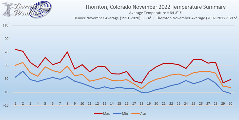
 The weather during the month of November in Denver metro area can offer just about anything. While it is normally a quiet month, it can be prone to extremes.