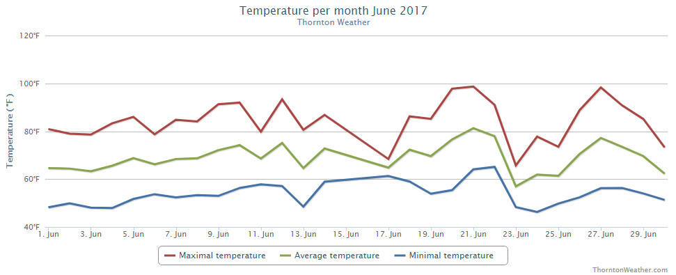
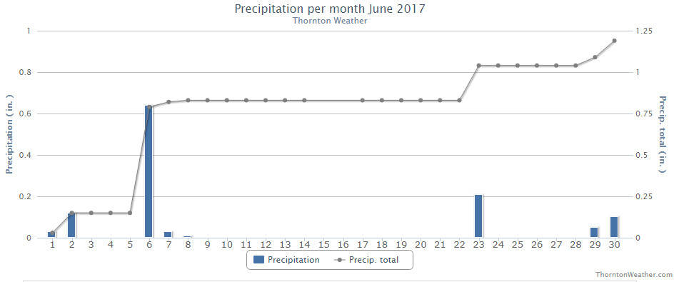
This year the weather in June has been most notable for its heat. That however is far less common than severe weather conditions with lightning, tornadoes and hail. All of these we see in our look back at this week in Denver weather history.
From the National Weather Service:
22-26
In 2012…the maximum temperature exceeded 100 degrees for five consecutive days. Two of the high temperatures on the 25th and 26th peaked at 105 degrees…which set the all time record for the month of June and tied the all time maximum temperature for Denver.
24
In 1873…there was a great deal of smoke from a fire in the mountains to the southwest of the city during the late afternoon.
In 1875…smoke from forest fires in the mountains to the southwest could plainly be seen from the city.
In 1958…a strong cold front produced a north wind gust to 55 mph at Stapleton Airport where blowing dust briefly reduced the visibility to 1 mile.
In 1982…one inch diameter hail pelted west Denver. A half inch of rain drenched the suburb of Englewood in 10 minutes. Hail piled up to 5 inches deep…snarling rush hour traffic and damaging some stores in a shopping center when the roof started leaking.
In 1988…lightning destroyed the chimney of a house near Evergreen. Another bolt demolished a radio transmitter in the area.
In 1989…golf ball size hail cut a swath 2 1/2 miles wide through open country 14 miles southwest of Bennett. The storm also dropped 1.75 inches of rain on the area. Hail to 3/4 inch in diameter damaged the car of a storm chaser just south of Bennett.
In 1996…a funnel cloud was sighted near Hudson where hail up to 1 3/4 inch diameter fell. Lightning struck a home in Littleton…which sparked a small fire on the roof. Thunderstorm wind gusts to 64 mph were recorded in Castle Rock.
In 2005…severe thunderstorms produced large hail across metro Denver. Hail as large as 1 inch in diameter fell near Castle Rock and Thornton. Hail to 3/4 inch was measured near Northglenn and Fort Lupton.
In 2006…severe thunderstorms raked metro Denver. Hail as large as 2 1/2 inches in diameter shattered automobile windshields in and near Boulder. Hail to 1 3/4 inches pounded areas in and near Lakewood and Morrison. Hail to 1 inch was measured in Wheat Ridge along with 7/8 inch hail in Arvada. Severe thunderstorm wind gusts estimated to 69 mph snapped power lines for a distance of one quarter mile near Castle Rock. Severe thunderstorm winds were measured to 60 mph in Sedalia. Hail as large as 1 inch in diameter fell near Evergreen and Castle Rock. Hail to 3/4 inch in diameter was reported in Louviers and near Conifer.
In 2014…damaging hail…from 1 to 2 inches in diameter…caused extensive damage to homes and automobiles over parts of Arapahoe and Douglas Counties including areas in and near: Aurora-Cherry Creek…Buckley Air Force Base…Denver International Airport and Parker. Officially…0.06 inches of rain fell at Denver International Airport…with a peak wind gust of 33 mph from the southeast.
In 2015…two colliding outflow boundaries merged over east Denver and northwest Aurora at the height of rush hour. The collision quickly spawned a severe thunderstorm that produced an EF1 tornado…damaging hail…torrential rain and flash flooding. The tornado touched down in east Denver and west Aurora. The tornado first touched down near Quebec and 6th Avenue. It then moved east northeast across the Lowry Campus into the west part of Aurora. The tornado then lifted near Mount Nebo Memorial Park. Some homes had minor roof damage with one former apartment building on the Lowry Campus had more significant roof damage. The tornado and intense thunderstorm winds uprooted trees…damaging vehicles and blocking roads. The storm produced torrential rain…2 to 2.5 inches…much of which fell in less than 30 minutes and resulted in flooded intersections and power outages. Flash flooding forced the evacuation of a theater at the Cherry Creek Shopping Center…where drifts of hail formed in the parking lot…and flooding set off alarms at the University of Denver`s Ritchie Center. Numerous water rescues were reported as vehicles stalled flooded intersections. Many stoplights were knocked out. The water was reportedly 3 feet deep on the South Broadway ramp to Interstate 25. The bike path along Cherry Creek was inundated with several feet of water at the height of the storm. Ironically…it was “Bike to Work Day”…which made for a long commute home for many. The South Platte River crested above flood stage for one hour. Employees still at work were urged to stay inside but others waded across flooded intersections downtown. About 30 flights had to be diverted from Denver International Airport. At Denver International Airport… only 0.05 inches of rain fell. A peak wind gust to 47 mph was observed from the southeast.
25
In 1873…forest fires produced a great deal of smoke in the mountains to the southwest of the city.
In 1958…an unusually cold day for summer set two temperature records for the date. Under cloudy skies with occasional drizzle…a record low maximum temperature of 55 degrees was established along with a record minimum temperature of 42 degrees.
In 1959…a waitress…working at a kitchen sink…was injured by a bolt of lightning…which struck the rear of a tavern in Denver. She was hospitalized.
In 1971…a tornado touched down briefly at a high school football field in Brighton…but caused no damage.
In 1981…3/4 inch hail pelted wheat ridge and hail to 1 1/4 inches fell in Louisville. A brief funnel cloud was sighted by national weather service personnel 4 miles east of Stapleton International Airport.
In 1982…a bolt of lightning struck a cabin in the foothills west of Denver. The resulting fire totally destroyed the cabin.
In 1987…golf ball size hail fell near Bennett.
In 1988…a tornado touched down 1 mile south of Watkins and was on the ground for 4 minutes. Another tornado was spotted just southeast of Barr Lake and was on the ground for 5 minutes. No damage was reported from either tornado. Lightning struck two rock climbers near Eldorado Springs. A 25-year-old man was killed…and a 21-year-old man suffered extensive injuries. Thunderstorm winds knocked over two elm trees near downtown Denver. One fell on a house destroying most of it. A nearby building was unroofed…and two cars were damaged. A truck that had been severely damaged by one of the Denver tornadoes 10 days before was hit again. Thunderstorm wind gusts to 51 mph were recorded at Stapleton International Airport.
In 1991…the temperature reached a high of 100 degrees… Setting a new record for the date.
In 1997…one inch diameter hail fell in Arvada and 1 1/2 inch hail in Boulder. Hail as large as 3/4 inches fell in Denver…Louisville…Westminster…and near Broomfield.
In 1999…thunderstorm winds gusted to 58 mph near Fort Lupton toppling an oil rig. A 37-year-old man was killed when he fell 55 feet from the derrick of the rig.
In 2001…four golfers and one construction worker received minor injuries from a nearby lightning strike on the Broadlands Golf Course in Broomfield.
In 2002…hail to 1 inch in diameter was measured in greenwood village.
In 2005…hail to 3/4 inch in diameter fell near Bennett and Roggen. A thunderstorm wind gust to 61 mph was recorded near Golden.
In 2009…lightning struck the Darlington prismatic electric fountain in City Park’s lake. The damage was estimated to be approximately $25000.
In 2010…wind gusts associated with a dry microburst downed several trees in the vicinity of 14th and federal…and near Bayaud St. and Clarkson St. in Denver. At Denver International Airport…a peak wind gust to 45 mph was observed from the southwest.
In 2015…severe thunderstorms developed late in the afternoon and continued in the late evening hours. The storms moved over parts of Adams…Arapahoe…Douglas and Weld Counties. The largest hail occurred near Aurora and Keenseburg…with hail up to tennis ball size or 2 1/2 inches in diameter. Elsewhere…the hail size ranged from nickel to half dollar size. At Denver International Airport…just a trace of rainfall was observed. A peak wind gust of 31 mph was also observed from the east.
25-26
In 1969…high winds raked Boulder causing one fatality and some injuries. One man was injured by a falling tree limb. At the National Center for Atmospheric Research in Boulder… Sustained winds of 55 to 60 mph with wind gusts to 123 mph were recorded.
In downtown Boulder…winds averaged 30 to 40 mph with gusts to 70 mph. Widespread minor damage occurred… Especially in the Table Mesa area of south Boulder. Much tree damage occurred in the older areas of Boulder where several trees were uprooted. A mobile home was overturned by the winds. At Stapleton Airport…west winds gusted to 43 mph on the 25th and 37 mph on the 26th.
In 1975…strong winds damaged utility lines…buildings… Vehicles…trees…and power lines in Boulder and other communities to the north of Boulder. Microburst winds gusted to 45 mph at Stapleton International Airport on the 25th.
In 1983…heavy rain fell in the foothills west of Denver with 1.50 inches in 30 minutes at Intercanyon. Heavy rain continued over metro Denver on the 26th with two-day storm totals at many locations ranging from 1.00 to 2.50 inches. Rainfall totaled 1.37 inches at Stapleton International Airport on the 26th.
In 1985…one to two inches of rain fell over metro Denver. At Stapleton International Airport…rainfall totaled 0.93 inches…thunderstorm winds gusted to 44 mph…and 7/10 inch hail was measured. The air mass was unusually cold for the season…and snow fell in the foothills above 8 thousand feet. The high temperature of only 63 degrees on the 26th equaled the record low maximum reading for the date.
In 2012…Denver broke the all-time record temperature for the month of June on the 25th when it reached 105 degrees. This also tied the all-time record maximum temperature in Denver. The maximum temperature of 105 degrees was then matched once more on the 26th. Sandwiched in between these records…the minimum temperature of 71 on the morning of the 26th…established a new record high minimum for the date.
Continue reading June 24 to June 30: This week in Denver weather history

 Extreme weather can occur during in month in Colorado we well know. June however is when traditional spring severe weather arrives in the state oftentimes with hail, damaging wind and tornadoes.