An extremely eventful week in weather history showing just how varied conditions can be. We of course see typical spring weather like tornadoes and hail but also a touch of snow and this week also marks the anniversary of the start of the Hayman Fire.
1-30
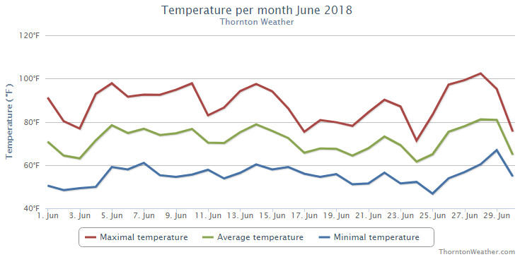
In 2012…it was the hottest June in Denver since weather records began back in 1872. The average temperature for the month was 75.0 degrees which was 7.6 degrees above normal. There were a total of seventeen 90 degree days in the month of June. The highlight of record setting month was a stretch of five consecutive 100 degree days from the 22nd to the 26th. This was only the third time in Denver weather history in which this happened. Two of the high temperatures during the stretch peaked at 105 degrees… Which set the all-time record for the month of June and tied the all-time maximum temperature for Denver.
2-7
In 1921…heavy rainfall for nearly a week…on top of streams already swollen by mountain snowmelt…produced widespread flooding over the South Platte River basin…including the tributaries through the canyons to the west and southwest of Denver. Heavy rainfall over the 6-day period totaled 3.36 inches in Boulder…4.98 inches in Morrison…4.27 inches in Castle Rock…and 2.94 inches in the city of Denver. Rainfall amounts in the foothills were estimated between 3 and 6 inches. The narrow-gage tracks of the Colorado and southern railroad were destroyed in the Platte Canyon. From the mouth of the canyon through the city to near Brighton… The river spread from 1/2 to nearly 1 1/2 miles wide… Flooding farm and pasture land and destroying or damaging many bridges. In the city…many businesses along with as many as 500 homes were inundated…forcing their evacuation. Bridges were swept away. The high waters flooded the rail yards and stock yards in lower downtown…closing three adjacent packing houses. The heavy rains also caused flooding on Boulder creek in Boulder on the 6th.
5-6
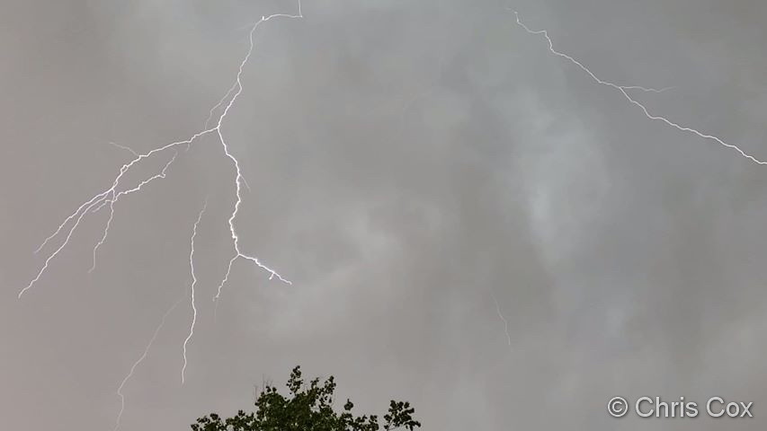
In 1977…lightning caused several power outages and moderate damage to a railroad building.
6
In 1954…thunderstorm winds at speeds of 50 mph with gusts as high as 59 mph briefly reduced the visibility to 1 mile in blowing dust at Stapleton Airport.
In 1967…the public reported golf ball to 1 3/4 inch diameter hail in the city…3 miles west-southwest of Stapleton International Airport. The amount of damage was unknown. Thunderstorm winds gusted to 46 mph at Stapleton International Airport.
In 1981…hail to 3/4 inch in diameter was reported in east Denver.
In 1990…golf ball size hail was reported near Strasburg on I-70 east of Denver.
In 1991…a tornado was spotted by national weather service personnel and weather spotters…14 to 17 miles northeast of Stapleton International Airport. A funnel cloud was sighted over south Aurora just east of Buckley Field…and a tornado was spotted just east of Watkins. No damage was reported. Thunderstorms moved through Aurora and dropped hail up to 1 inch in diameter. The storms also produced heavy rain… Up to 1 inch in 30 minutes…causing flooding of streets. Water was reported hood deep…stranding motorists. Water covered fire hydrants at some intersections.
In 1995…a waterspout sighted over Standley Lake in northern Jefferson County…quickly dissipated once it reached shore. A brief tornado…which was momentarily visible by a dust debris cloud on the ground…damaged the roof of a house in Westminster. A funnel cloud was sighted just south of Lafayette. Hail from 3/4 to 1 1/4 inches in diameter fell over north Boulder. Thunderstorm outflow produced north wind gusts to 44 mph at Denver International Airport.
In 1997…a tornado touched down near baseline reservoir just east of Boulder. The tornado struck a home…tearing off part of the roof. A storage building nearby was nearly leveled and 5 trees were uprooted. The twister then moved onto baseline reservoir…forming a huge waterspout. Several recreational vehicles and a boat dock were also damaged. A nearly stationary line of thunderstorms dumped 4.60 inches of rain on portions of Thornton. Extensive flooding of streets and underpasses and other low lying areas was reported. Several businesses were flooded and basements in the area were damaged. Rainfall totaled 1.02 inches at Denver International Airport and 1.24 inches at the site of the former Stapleton International Airport. Large hail…up to 1 3/4 inches in diameter…fell over the city of Denver with 3/4 inch hail measured in Littleton and near Henderson.
In 1999…high winds developed for a brief time in and near the foothills of Boulder. The Gamow Tower on the University of Colorado campus recorded a wind gust to 87 mph. Winds peaked to 71 mph atop Niwot Ridge near the continental divide west of Boulder.
In 2003…a small tornado touched down near Strasburg…but did no damage.
In 2012…severe thunderstorms broke late in the evening…striking areas hardest from Denver southward. Locations impacted by the storms included but were not limited to: Aurora…Castle Rock…Centennial…Highlands Ranch…Lone Tree…Parker and Surrey Ridge. The storms produced a barrage of
large hail…damaging straight line winds…flash flooding and several short lived tornadoes. The hail ranged in size from 1 to 2 inches in diameter…and caused extensive damage to homes and automobiles. The hail inundated the roadways with several inches of hail in Douglas County. Consequently…snow plows had to be called out to clear the roadways. The combination of torrential hail and heavy rain produced flash flooding in parts of Elbert…Douglas and Arapahoe Counties…as thunderstorms brought up to 3.35 inches of rain to some areas within 90 minutes. In Aurora…Picadilly Road was closed from flooding north of 6th Avenue. A water rescue took place on South Gun Club Road in Arapahoe County…where floodwaters were rushing to depth of 3 feet. Flash flooding forced the closure of several streets and roads from Parker south to The Pinery…where the floodwaters inundated the roadway with up to 2 feet in several locations. At Centennial Airport…a historic B-17 Flying Fortress suffered extensive damage as hailstones as large as ping pong balls struck the aircraft. Although the airframe itself did not require repair…the fabric-covered ailerons and elevators were extensively damaged. The hail came straight down and punched holes in the fabric-covered control surfaces. The aircraft landed just hours before the storm hit to participate in a weekend tour stop. Lightning also struck two homes…one in Lakewood and the other in Parker. Straight line winds downed trees and power lines in Aurora. As a result…scattered electrical outages affected around five thousand residents. At Denver International Airport…0.61 inches rainfall was recorded along with a peak wind gust of 41 mph.
In 2016…powerful thunderstorms fired up along the urban corridor and produced damaging hail…strong outflow winds… heavy rain and lightning. Golf-ball size hail in Highlands Ranch caused extensive damage including broken windows on homes and windshields on vehicles. Heavy rainfall…also produced street flooding. In and around Highlands Ranch… anywhere from 2.3 to 2.8 inches of rainfall was observed… with 1 to 1.5 inches around metro Denver. At Denver International Airport…0.38 inches of rainfall was recorded.
6-7
In 2004…a brief hot spell produced 3 temperature records. High temperatures of 95 degrees on the 6th and 98 degrees on the 7th were record maximum temperatures for the dates. Low temperature of 68 degrees on the 7th was a record high minimum for the date.
In 2007…an unusually strong storm system brought very strong winds to the Front Range foothills and urban corridor. Peak gusts included: 92 mph at Boulder…85 mph…2 miles southwest of Boulder…83 mph…10 miles south of Boulder and 55 mph at Denver International Airport. High winds forced the closure of Mt. Evans Road and Trail Ridge Road. Several trees were uprooted across the urban corridor. In Aurora… The driver of a car was injured when some building material blew off the Fitzsimmons complex. The debris landed on the car and knocked the driver unconcious. The wind forced the cancellation of 60 flights at Denver International Airport. Xcel reported outages in Boulder…Denver…Lakewood and Longmont.
In 2012…severe thunderstorms broke late in the evening… Striking areas hardest from Denver southward. Locations impacted by the storms included but were not limited to: Aurora…Castle Rock…Centennial…Highlands Ranch…Lone Tree… Parker and Surrey Ridge. The storms produced a barrage of large hail…damaging straight line winds… Flash flooding and several short lived tornadoes. The hail ranged in size from 1 to 2 inches in diameter…and caused extensive damage to homes and automobiles. The hail inundated the roadways with several inches of hail in Douglas County. Consequently… Snow plows had to be called out to clear the roadways. The combination of torrential hail and heavy rain produced flash flooding in parts of Elbert…Douglas and Arapahoe counties…as thunderstorms brought up to 3.35 inches of rain to some areas within 90 minutes. In Aurora…Picadilly Road was closed from flooding north of 6th Avenue. A water rescue took place on south Gun Club Road in Arapahoe County…where floodwaters were rushing to depth of 3 feet. Flash flooding forced the closure of several streets and roads from parker south to the Pinery…where the floodwaters inundated the roadway with up to 2 feet in several locations. At Centennial Airport…a historic B-17 Flying Fortress suffered extensive damage as hailstones as large as ping pong balls struck the aircraft. Although the airframe itself did not require repair…the fabric-covered ailerons and elevators were extensively damaged. The hail came straight down and punched holes in the fabric-covered control surfaces. The aircraft landed just hours before the storm hit to participate in a weekend tour stop. Lightning also struck two homes…one in Lakewood and the other in Parker. Straight line winds downed trees and power lines in aurora. As a result…scattered electrical outages affected around five thousand residents. At Denver International Airport… 0.61 inches rainfall was recorded along with a peak wind gust of 41 mph.
7
In 1904…a thunderstorm produced south winds to 40 mph with gusts to 50 mph…but only a trace of rain.
In 1942…heavy thunderstorm rainfall in south Denver caused flooding of shops…stalled motorists…and halted tramway service temporarily. Lightning damaged houses…but there was no loss of life. Precipitation totaled 0.53 inch in downtown Denver.
In 1951…a 24×65 foot roof of a cow barn was lifted off the building and blown to the ground by a “twister” near Fort Lupton.
In 1961…small hail and heavy rain damaged property and crops in southwest metro Denver…including the southwest section of the city…Lakewood…and Littleton. Precipitation totaled 1.20 inch…11 miles southwest of Stapleton Airport. Complete primary and secondary rainbows were sighted by national weather service observers at Stapleton Airport.
In 1968…severe thunderstorms moving to the northeast through sections of Denver caused local flooding of streets and damage to trees and gardens from hail 1/2 to 1 3/4 inches in diameter. One man was killed and 2 were injured at the Wellshire Golf Course when lightning struck a tree under which they had taken shelter. At another golf course… A man was mortally injured by lightning. Marble to golf ball size hail fell over downtown Denver. Hail to 3/4 inch in diameter was measured in Westminster.
In 1975…hail up to 3/4 inch diameter fell in Boulder.
In 1978…a man standing under a tree on a golf course in Denver was struck in the arm by lightning. Wind gusts to 60 mph and golf ball size hail pelted west and south Denver.
In 1986…7/8 inch hail was measured in Lafayette.
In 1990…a thin…rope-shaped tornado touched down east of the intersection of State Highway 2 and 96th avenue just north of the rocky mountain arsenal. No damage was reported.
In 1992…a thunderstorm wind gust to 60 mph was recorded in Boulder. A funnel cloud was sighted by a highway patrol officer just northwest of Stapleton International Airport where thunderstorm winds gusted to 51 mph. Spotters and state patrol officers reported funnel clouds in the northwestern part of metro Denver…near Golden…and 7 miles northwest of Stapleton International Airport.
In 1993…non-convective high winds pummeled the Front Range foothills during the late morning and afternoon. Speeds of 60 to 80 mph were common. The winds caused several power outages as well as uprooting trees. In Lafayette…a 4-year- old boy was slightly injured while standing on the roots of a large tree which was toppled by the winds. The boy fell 10 feet to the ground and was bruised and scraped. A tree fell onto a parked car in Boulder…causing about 35 hundred dollars in damage. West wind gusts to 41 mph were recorded at Stapleton International Airport where a thunderstorm produced 1/8 inch hail at daybreak.
In 1995…severe thunderstorms produced large hail across west and north metro Denver from Golden to Westminster and Fort Lupton. Hail ranged in size from 3/4 to 2 inches in diameter. The largest hail fell in Fort Lupton. A weak tornado produced a brief dust and debris cloud in a corn field 3 miles northeast of Hudson.
In 1997…two plumbers were injured…one critically…when lightning struck a pipe on which they were working in an apartment building under construction in Denver. The bolt apparently hit one man in the hand…passed through his chest…and struck the other worker. The critically injured man…died a few days later. Lightning also injured a man…while he was talking on a telephone in ward. The bolt passed through the phone line burning his ear.
In 2001…hail as large as 7/8 inch in diameter fell in Westminster.
In 2012…severe thunderstorms brought damaging wind and hail…heavy rain and flash flooding. The storms produced hail from 1.5 to 2.5 inches in diameter. In addition to the large hail…heavy rain from 1 to 2 inches also accompanied the storms. The combination of hail and heavy rain caused extensive street flooding across Aurora…Castle Rock…Centennial…Cherry Creek… Englewood…south Denver…Highlands Ranch… Lakewood and Littleton. The hail was reportedly “knee deep” in several areas making roads impassable. As a result… Snow plows had to be summoned to clear the streets. In Castle Rock…a King Soopers supermarket sustained extensive damage when roof partially collapsed under the weight of the hail. At Denver International Airport…0.61 inches of rainfall was again recorded along with a peak wind gust of 40 mph. Total property damage estimates along the Front Range for the 6th and 7th combined was 321.1 million dollars.
In 2016…large hail up to 1 inch in diameter was observed in Castle Rock.
Continue reading June 6 to June 12: This week in Denver weather history

 Extreme weather can occur during in month in Colorado we well know. June however is when traditional spring severe weather arrives in the state oftentimes with hail, damaging wind and tornadoes.