October 4 to October 10 - Today in Denver weather history
A very eventful week in Denver weather history with a wide variety of events from snow to summer-like severe weather. Most notable is five years ago today when multiple tornadoes touched down in the Brighton area. Read more about it below and check out the video on Examiner.com.
From the National Weather Service:
From the 3rd to the 4th:
In 1969…the first snowfall of the season totaled 16.0 inches at Stapleton International Airport. There was a thunder snow shower on the evening of the 3rd…but otherwise little wind with the storm. The greatest snow depth on the ground was 8 inches due to melting. Heavy wet snow accumulated on trees…which were still in full leaf…and caused widespread damage from broken limbs and downed utility lines.
From the 3rd to the 5th:
In 1984…the remnants of pacific hurricane polo produced heavy rain over northeastern Colorado. Most locations received between 1.00 to 2.50 inches of rain…but 3.45 inches fell in Littleton. Rainfall totaled 1.73 inches at Stapleton International Airport…where north winds gusted to 24 mph.
On the 4th:
In 1912…sustained south winds to 55 mph with gusts to 60 mph raised the temperature to a high of 83 degrees… The warmest temperature of the month that year.
In 1924…west winds were sustained to 46 mph with gusts to 50 mph in the city. The apparent Bora winds cooled the temperature to a high of 57 degrees from a high of 70 degrees on the 3rd.
In 2004…several small tornadoes touched down near Brighton… Barr lake…and Hudson in Adams and southern weld counties. Most of these caused no damage. However…a small tornado 5 miles southeast of Brighton caused extensive damage to a recreational vehicle and severely damaged a barn. The barn was torn from its foundation…and the roof was thrown 100 feet. Four llamas in the barn were injured when it collapsed.
September 27 to October 3 - This week in Denver weather history
With the end of summer and the arrival of fall, looking back at Denver weather history we start to see more mentions of snow. It is of course not the only notable weather event this time of year. We still have received severe thunderstorms, damaging winds, and 90 degree plus heat.
From the National Weather Service:
From the 25th to the 27th:
in 1996…an early season snowstorm brought heavy snow to the Front Range eastern foothills. Snowfall totals included: 8 to 12 inches around Conifer…7 inches on Floyd Hill…and 6 inches at both bailey and Chief Hosa. Snowfall totaled only 4.7 inches at the site of the former Stapleton International Airport. This was the first measurable snow of the season. After the passage of a strong cold front…north winds gusted to 38 mph at Denver International Airport on the 25th.
From the 26th to the 28th:
In 1936…the heaviest snowfall ever recorded in September and the heaviest snowfall ever recorded so early in the season dumped a total of 16.5 inches of snow on downtown Denver and 21.3 inches at Denver municipal airport. The 15.0 inches of snow measured from 6:00 pm on the 27th to 6:00 pm on the 28th is the greatest 24 hour snowfall ever recorded in September. This was the first snow of the season. The snow was intermittent through the 26th…but continuous from early afternoon on the 27th to around midnight on the 28th…except for a period of rain during the afternoon of the 28th which contributed to a loss of depth on the ground. The greatest snow depth on the ground downtown was 13 inches with 8 inches at Denver municipal airport. There were no high winds with the storm and traffic was interrupted for only a short period. The storm produced property damage estimated at 7 million dollars. With trees and shrubs in full foliage…the leaves caught and held the heavy water-laden snow…until the branches snapped from the weight. More than 3000 workmen were called to remove the debris and snow from the city. The city firemen who were off duty…as well as all the reserves… Were asked to report to their stations. All schools in the city remained open…but attendance was only 50 percent of normal. Grade school students were sent home at noon on the 28th. The early storm caught stockmen with many cattle still in higher ranges. Warm weather followed the snow…which had all melted by the end of the month…except for a few inches in sheltered places.
On the 27th:
In 1877…smoke from heavy forest fires in the mountains spread over the city on upper wind currents.
In 1935…the first snow of the season was 2.8 inches in downtown Denver. The low temperature dipped to 31 degrees for the first freeze of the season.
September 20 to September 26 - This week in Denver weather history
Looking back at this week in Denver history we start to see more of the signs that summer is coming to an end and fall and winter are right around the corner. Summer-like severe weather can still occur but we also start to see more cold temperatures and occasions with snow become more prevelant.
From the National Weather Service:
20
In 1921…an apparent Bora produced northwest winds sustained to 44 mph with gusts to 64 mph.
In 1955…hail stones 1/2 to 3/4 inch in diameter were reported across parts of the city of Denver.
In 1992…weather observers at Buckley Air National Guard base sighted two tornados southeast of the base. The tornados were short-lived and caused no injuries or damage.
20-21
In 1963…heavy rain and hail caused local flooding in southeast Denver. Thunderstorm rainfall was only 0.60 inch at Stapleton Airport on the 20th.
In 1983…the cold front on the 19th brought an unusually cold air mass into metro Denver for so early in the season. The temperature dipped to a daily record minimum of 28 degrees on both days.
In 1995…a vigorous late summer storm brought the season’s first heavy snow to portions of metro Denver. Millions of trees were damaged and power lines downed as 4 to 8 inches of heavy wet snow settled on fully leafed trees in the Boulder and Denver areas. Branches snapped and trees split under the weight of heavy snow…downing power lines. Firefighters responded to numerous transformer fires. Around 100 thousand people were left without electricity in Boulder and Denver areas alone. It took over a week to fully restore power to some areas. Insurance claims were estimated to be around 6 million dollars to homes in metro Denver and about 500 thousand dollars in damage to automobiles. It was estimated that about 80 percent of 125 million dollars worth of city owned trees in Denver were damaged. Snowfall totaled 7.4 inches at the site of the former Stapleton International Airport where the greatest depth of snow on the ground was only 4 inches due to melting. Temperature records were set on the 21st when the thermometer dipped to a record low reading of 27 degrees and climbed to a high of only 36 degrees… Setting a record low maximum for the date. North winds gusted to 29 mph at Denver International Airport on the 20th.
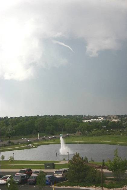
This funnel cloud was seen on Tuesday from the Thornton Civic Center (looking north) on June 10th. Image courtesy Lisa Wilson, the City of Thornton.
June 2009 went down in the history books as one of the more unusual June’s on record. Residents are all of course well aware of the string of severe storms but the Mile High City also were unusually cool and certainly very wet.
In terms of precipitation, a whopping 4.86 inches of rain fell at the official measuring site at Denver International Airport during the month – the second wettest June since recordkeeping began here in 1872. We missed out on breaking the record by only a tenth of an inch as the all-time wettest was back in 1882 when 4.96 inches fell in the rain bucket. Nevertheless, we easily exceed the normal rainfall total for the month which is 1.56 inches. In fact, we beat that in one day on June 23rd when 1.64 inches fell at DIA. Here in Thornton we didn’t measure near as much precipitation having recording 3.44 inches for the month. This is more in line with what areas closer to the actual metro area recorded than what was recorded at DIA. See below for details on the controversy about Denver’s climate records.
Temperature wise, we were very cool as well, never breaking the 90 degree mark during the month. Two days, the 29th and 30th, came close with 89 degrees being recorded as the high temperatures on those days. This was the first time since 2003 no 90 degree days were recorded in June. Before that, you would have to go way back to 1972 to find another June when that happened. The average temperature for June 2009 was 64.4 degrees, 3.2 degrees below the normal of 67.6. That may be cool but it was nowhere near the record low average for June which is 60.6 set in 1967. Thornton was just a touch warmer than the official stats from DIA as we recorded 90.0 degrees on the 29th. Similarly, Thornton’s average temperature was just a bit cooler at 63.2 degrees.
Then of course there were the storms. Tornadoes, funnel clouds and hail will probably be the most memorable events of the month, especially the twister that struck the Southlands Shopping Center in Aurora. In all, DIA recorded 18 days with thunderstorms – eight more than normal. 15 days had precipitation versus the normal of nine. All those storms also took a toll on what is normally a sunny month. On average Denver has 70 percent of possible sunshine during the month. This year we only recorded sunshine 51 percent of the time.
All that rain we have received in the last two months, especially in June, helps to make one other statistic a bit more tolerable. Colorado’s snow season runs from July 1 to June 30 each year and for the 2008 – 2009 snow season, we recorded a meager 38.1 inches of the white stuff. That is a whopping 29 inches below the normal of 67.1 inches. Thornton fared a bit better on the snowfall front but not by a lot having recorded 48.5 inches for the season.
There is always a ‘but’…
As always, we would like to remind everyone that all official Denver weather statistics are now taken out at Denver International Airport. As we outlined a few months ago, moving the official monitoring station 13 miles away has made quite a difference in Denver’s climate records. Evidence suggests that temperatures and precipitation as measured at DIA differ greatly from what would have been recorded at the old site at Stapleton or near downtown Denver.
The National Weather Service has finally acknowledged this and has setup a measuring station at the Denver Museum of Nature and Science (click here to view current conditions from it on the Weather Underground). However, they maintain that Denver’s official statistics will continue to be recorded at DIA and as a result, Denver’s climate records will forever have an asterisk next to them. If you compare June’s statistics from this new station to the ‘official’ ones at DIA, you will notice that much of what we discuss above, including the temperature and precipitation, would be much different were the statistics being kept by the new station closer to where people actually live.
Denver climate summary for the month of June 2009 – From the National Weather Service
CLIMATE NORMAL PERIOD 1971 TO 2000
CLIMATE RECORD PERIOD 1872 TO 2009
WEATHER         OBSERVED          NORMAL  DEPART  LAST YEAR'S
                 VALUE   DATE(S)  VALUE   FROM    VALUE  DATE(S)
                                          NORMAL
................................................................
TEMPERATURE (F)
RECORD
 HIGH             104   06/26/1994
 LOW               30   06/02/1951
HIGHEST            89   06/30       104     -15       95  06/26
                        06/29
LOWEST             41   06/08        30      11       37  06/12
AVG. MAXIMUM     77.7              82.1    -4.4     83.9
AVG. MINIMUM     51.1              53.0    -1.9     50.9
MEAN             64.4              67.6    -3.2     67.4
DAYS MAX >= 90      0               6.3    -6.3       10
DAYS MAX <= 32      0               0.0     0.0        0
DAYS MIN <= 32      0               0.0     0.0        0
DAYS MIN <= 0       0               0.0     0.0        0
PRECIPITATION (INCHES)
RECORD
 MAXIMUM         4.96   1882
 MINIMUM            T   1890
TOTALS           4.86              1.56    3.30     0.73
DAILY AVG.       0.16              0.05    0.11     0.02
DAYS >= .01        15               8.7     6.3        4
DAYS >= .10         9                MM      MM        2
DAYS >= .50         4                MM      MM        1
DAYS >= 1.00        1                MM      MM        0
GREATEST
 24 HR. TOTAL    1.64R  06/23 TO 06/23              0.70     06/04 TO 06/05

SNOWFALL (INCHES)
RECORDS
 TOTAL            0.4   1919
TOTALS            0.0                T
DEGREE_DAYS
HEATING TOTAL      78                60      18       64
 SINCE 7/1       5616              6128    -512     6056
COOLING TOTAL      68               136     -68      144
 SINCE 1/1         94               161     -67      172
FREEZE DATES
RECORD
 EARLIEST     09/08/1962
 LATEST       06/02/1951
EARLIEST                        10/07
LATEST                          05/05
.................................................................
WIND (MPH)
AVERAGE WIND SPEED              8.4
RESULTANT WIND SPEED/DIRECTION   2/147
HIGHEST WIND SPEED/DIRECTION    53/260    DATE  06/26
HIGHEST GUST SPEED/DIRECTION    68/270    DATE  06/26
SKY COVER
POSSIBLE SUNSHINE (PERCENT)   51
NUMBER OF DAYS FAIR            3
NUMBER OF DAYS PC             22
NUMBER OF DAYS CLOUDY          5
AVERAGE RH (PERCENT)     65
WEATHER CONDITIONS. NUMBER OF DAYS WITH
THUNDERSTORM             18     MIXED PRECIP               1
HEAVY RAIN                7     RAIN                      10
LIGHT RAIN               17     FREEZING RAIN              0
LT FREEZING RAIN          0     HAIL                       3
HEAVY SNOW                0     SNOW                       0
LIGHT SNOW                0     SLEET                      0
FOG                      14     FOG W/VIS <= 1/4 MILE      6
HAZE                     10

-  INDICATES NEGATIVE NUMBERS.
R  INDICATES RECORD WAS SET OR TIED.
MM INDICATES DATA IS MISSING.
T  INDICATES TRACE AMOUNT.
May 17 - May 23 - This week in Denver weather history
As we move further into the severe weather season, we begin to see that transition in our look back at Denver weather history. There are many more mentions of lightning, wildfires, tornadoes, hail and other season weather conditions.
14-18
In 1996…a period of unusually warm weather resulted in 4 record maximum temperatures in 5 days. The record high temperatures were 87 degrees on the 14th…89 degrees on the 15th…and 93 degrees on both the 16th and 18th. The temperature climbed to only 81 degrees on the 17th which was not a record.
16-17
In 1981…a heavy rain storm dumped 1 to 2 1/2 inches of rain across metro Denver. Rainfall totaled 1.27 inches at Stapleton International Airport where north winds gusted to 38 mph on 17th.
In 1983…a very strong late spring storm dumped heavy snow over the Front Range. Strong winds with the storm produced blizzard conditions at times. Sustained winds were 20 to 40 mph with a peak gust to 55 mph at Stapleton International Airport. The foothills received 1 to 2 feet of snow with 4 to 12 inches along the foothills. Howling winds whipped the snow into drifts several feet deep…closing schools and highways. Stapleton International Airport was forced to reduce flight operations…closing 2 of 4 runways and stranding hundreds of travelers. Most of the damage and inconvenience caused by the storm was in power outages… Which occurred when wind and heavy wet snow caused hundreds of power poles to snap and topple. About 20 square miles of Denver were blacked out. Precipitation from the storm totaled 1 to 3 inches. At Stapleton International Airport… Snowfall totaled 7.1 inches with a maximum snow depth on the ground of only 2 inches due to melting. The high temperature of 40 degrees on the 17th was a record low maximum for the date. Due to the heavy moisture content of the storm…widespread street flooding occurred on the 18th when much of the snow melted under the warm May sun and temperatures climbed to a high of 57 degrees.
In 1995…significant moisture and upslope flow caused flooding across metro Denver. Moderate to heavy rains… Which began on the evening of the 16th…developed in the foothills and spread eastward over metro Denver throughout the night. The heavy rains brought many creeks and small streams to bankfull or slightly over. Locations along the foothills received between 3 and 4 inches of rainfall from the storm. Boulder received 3.60 inches of rainfall for the 24-hour period…causing minor street flooding near small streams. To the northwest of Boulder…a bridge which crossed Fourmile Creek was washed out. Numerous rock and mudslides occurred in foothills canyons…closing portions of U.S. Highways 6 and 40 and State Highway 119 for a few hours at a time. Rocks were piled 6 feet deep on a stretch of State Highway 119 along with Boulders as large as cars on U.S. Highway 6. A parking lot near a creek in Golden caved in leaving a hole the size of an 18-wheeler. Rushing water washed out a 50-foot stretch of a road in Westminster. Rainfall totaled 1.75 inches at Denver International Airport…but only 1.42 inches at the site of the former Stapleton International Airport.
As we begin to dry out from an incredibly wet April storm, we can take a look at some of the numbers from the three day event. Being on the warmer east side of the Denver area, Thornton did not receive a tremendous amount of snow as temperatures here simply remained too warm. What we did get though was rain – and LOTS of it.
ThorntonWeather.com measured 3.06 inches of precipitation – the most we have recorded for a single weather event since we went operational in October 2006. Friday was the wettest of the three days with 1.86 inches recorded – not a single day record for ThorntonWeather.com but still a great amount for our arid climate. The steady and more or less constant rain brought much needed moisture and helps to make up for what has been a dry snow season thus far.
Denver did officially set a record for Friday when 1.16 inches of precipitation was recorded at Denver International Airport – the most ever on April 17th. The old record was 1.00 inch set in 1920.
While we remain well behind normal on snow for the season, for the calendar year thus far, the storm put Denver ahead of the curve on precipitation. Normally by this date we would have had 3.36 inches of precipitation. Since January 1 Denver has now recorded 3.61 inches, 0.25 inch above normal, so that is definitely good news.
As we mentioned, Thornton did not receive a lot of snow from this event. We recorded 3.1 inches total as the rain / snow mix we saw at many times resulted in what snow did fall being compacted by rain immediately thereafter. Other areas of the Front Range however, those primarily west and south, were a touch colder and received a great deal of snow. A quick look at a few of the snow totals from the event:
Pinecliffe – 52 inches
Rollinsville – 51 inches
Nederland – 37 inches
Blackhawk – 36 inches
Evergreen – 29 inches
Cherry Creek Dam – 15.3 inches
Parker – 14 inches
Highlands Ranch – 13.4 inches
Boulder – 10 inches
Broomfield – 9.3 inches
Arvada – 8.8 inches
Denver, Stapleton – 3.3 inches
ThorntonWeather.com – 3.1 inches
Denver International Airport – 2.6 inches (Denver’s official site)
All of that moisture and a coming week of temperatures in the 70’s are sure to truly start greening up the landscape. It won’t be long now for sure and you will be mowing the lawn!
Denver officially set a new record high temperature for March 2nd.
Updated, 5:30pm: Denver’s official high temperature today reached 74 degrees at 3:08pm, beating the old record of 72 degrees by two.
Original post, 2:39pm: Denver has officially broken the high temperature record for today, March 2nd. At 1:52pm the thermometer at Denver International Airport reached 73 degrees, besting the old record of 72 degrees set way back in 1901. Here in Thornton we were a touch warmer reaching a high of 74.1 degrees.
This afternoon there is a chance the temperature could go a degree or two higher thus further increasing the record.
Is this really a record? Since moving Denver’s official weather recording station to DIA, many weather enthusiasts believe our weather and climate records are being unduly altered. Examiner.com just launched an investigative feature into this problem today – check out part 1 of our series on Examiner.com: Do Denver weather and climate records have an asterisk attached?
March 1 to March 7 - This week in Denver weather history
Looking at this week in Denver weather history, it is easy to see why March is known as Denver’s snowiest month. There are numerous instances of major winter storms dumping snow on the city that was measured not in inches – but feet!
From the National Weather Service:
28-1
IN 1875…6 INCHES OF SNOW FELL FROM 3:15 PM ON THE 28TH TO 1:00 AM ON THE 1ST. PRECIPITATION FOR THE TWO DAYS WAS 0.50 INCH.
29-1
IN 1896…SNOWFALL TOTALED 5.5 INCHES IN THE CITY. NORTHEAST WINDS GUSTED TO 24 MPH.
IN 1948…SNOWFALL TOTALED 5.9 INCHES IN DOWNTOWN DENVER. NORTH WINDS WERE SUSTAINED TO 15 MPH.
1
IN 1904…WEST WINDS WERE SUSTAINED TO 42 MPH WITH GUSTS AS HIGH AS 58 MPH. THE CHINOOK WINDS WARMED THE TEMPERATURE TO A HIGH OF 67 DEGREES.
IN 1906…SNOWFALL WAS HEAVY AND TOTALED 7.5 INCHES OVER DOWNTOWN DENVER. NORTHEAST WINDS WERE SUSTAINED TO 37 MPH.
IN 1940…SNOWFALL WAS HEAVY AND TOTALED 7.7 INCHES IN DOWNTOWN DENVER.
IN 1943…6.0 INCHES OF SNOW FELL OVER DOWNTOWN DENVER. NORTH WINDS WERE SUSTAINED TO 19 MPH.
Denver and Thornton's March 2009 climatological preview
March in Denver typically means frequent and rapid weather changes. The days grow longer and we start enjoying more sunshine and sometimes summer-like weather. However, on occasion arctic air masses can still force their way south into Colorado dropping temperatures quickly and markedly.
These changes are due to Marches “in between” status – elements during the month have much in common with winter and spring. In addition to arctic fronts, Pacific storms frequently move across Colorado from the west and warm moist air streams up from the Gulf of Mexico northeastward into the state. When these cold fronts collide with the warmer air masses the result can be some crazy weather.
What are the odds of a white Denver Christmas? Not very good.
As Christmas gets closer everyone always wonders if we are going to get the proverbial white Christmas. Unfortunately, if you look at Denver and Thornton weather history, the chances arent all that good but it also depends on what you define as a white Christmas. December just isnt that snowy of a month, ranking as only the fourth snowiest (behind March, November and April) so historically we have a bit of a disadvantage.