Tag Archives: December Weather

December 2013 weather recap: Record setting hot and cold, little snow

Thornton and the Denver area closed out 2013 with a display of typically highly variable weather.  We recorded some record low temperatures followed by unseasonably warm conditions.  One thing that was lacking was snow.

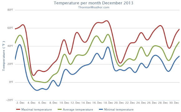
The first three days of the month started out quite mild with highs well above normal.  That changed quickly midday on the third as low pressure moved in bringing an extended Arctic blast.

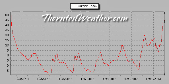
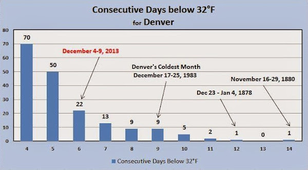
For six straight days high temperatures remained stubbornly below freezing and lows dipped into the single digits.  The cold snap was notable but not record-setting in terms of length.  Two daily low temperature records were tied or broken however.

Warmer weather returned on the 10th as the mercury finally started to climb.  Unseasonably warm temperatures became the rule for the next nine days that included a record high temperature on the 18th.

The last third of the month was a bit more variable with its ups and downs but overall warmer than normal conditions.

Overall Thornton’s monthly average temperature came in at 29.2 degrees.  Out at Denver International Airport where the Mile High City’s official stats are recorded, it was a bit cooler with an average of 28.4 degrees.  Both were below Denver’s December average of 30.0 degrees.

Thornton recorded nine days with high temperatures that failed to reach 32 degrees.  On five days, low temperatures dropped below zero.  Denver saw eight days with highs below freezing, six with lows below zero.

The warmest temperature of the month in Thornton came on the 18th when we recorded 66.8 degrees. Our coldest was -9.3 degrees on the 5th.  Denver’s warmest day was on the 18th as well with a high of 68 degrees.  Its lowest temperature was -15 degrees on the 5th.

Four temperature records were tied or broken in Denver.

The low temperature of -13 degrees on December 4th shattered the old record low for the date of -5 degrees last set in 2008.  The following day, on December 5th, the low temperature of -15 degrees tied the record low last set in 1972.

The mild weather December 18 saw two records.  The high of 68 degrees broke the previous high temperature record for the date of 66 degrees last set in 1979.  Also, the day tied the record high minimum for the 18th of 40 degrees set in 1917.

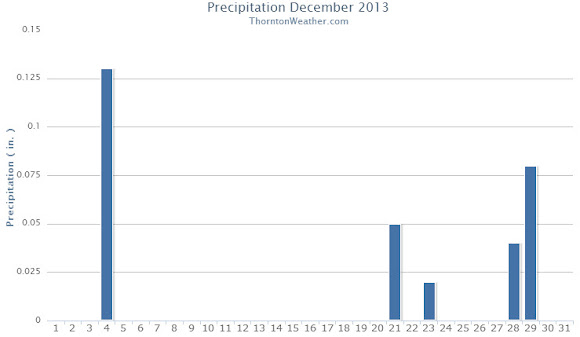
Precipitation for the month of December 2013 was not as noteworthy as the temperatures.  Thornton recorded only 0.24 inches in our bucket while Denver received 0.25 inches.  Both were a good bit below the December average of 0.35 inches.

Snow was similarly less than extraordinary.  Thornton measured 5.7 inches of the white stuff while Denver lagged that with 4.7 inches.  Both totals were below the normal for December of 8.5 inches.  Seasonal snowfall totals at this point are about half of what they normally are.

Click here to view Thornton’s December 2013 climate summary.

Thornton's December 2013 Temperatures.
Thornton’s December 2013 Temperatures.
Thornton's December 2013 Precipitation.
Thornton’s December 2013 Precipitation.
CLIMATE REPORT
NATIONAL WEATHER SERVICE BOULDER, CO
200 AM MST WED JAN 1 2014

...................................

...THE DENVER CO CLIMATE SUMMARY FOR THE YEAR OF 2013...

CLIMATE NORMAL PERIOD 1981 TO 2010
CLIMATE RECORD PERIOD 1872 TO 2013

WEATHER         OBSERVED          NORMAL  DEPART  LAST YEAR`S
                 VALUE   DATE(S)  VALUE   FROM    VALUE  DATE(S)
                                          NORMAL
................................................................
TEMPERATURE (F)
RECORD
 HIGH             105   06/26/2012
                        06/25/2012
                        07/20/2005
 LOW              -29   01/09/1875
HIGHEST           100   07/11        64      36      105  06/26
                        06/11                             06/25
LOWEST            -15   12/05        36     -51       -6  01/11
AVG. MAXIMUM     63.9              64.7    -0.8     68.4
AVG. MINIMUM     36.3              36.3     0.0     39.3
MEAN             50.1              50.5    -0.4     53.9
DAYS MAX >= 90     54              39.6    14.4       73
DAYS MAX <= 32     29              20.0     9.0       19
DAYS MIN <= 32    169             156.9    12.1      132
DAYS MIN <= 0      11               5.8     5.2        4 
PRECIPITATION (INCHES) 
RECORD 
 MAXIMUM        23.31   1196 
 MINIMUM         7.29   2008 
TOTALS          17.60             14.30    3.30    10.11 
DAILY AVG.       0.05              0.04    0.01     0.03 
DAYS >= .01        82              79.7     2.3       52
DAYS >= .10        42              34.9     7.1       23
DAYS >= .50         8               7.6     0.4        9
DAYS >= 1.00        3               2.3     0.7        1
GREATEST
 24 HR. TOTAL    2.39   MM                       12/31 TO 12/31
                                                          12/31 TO 12/31
                                                          12/31 TO 12/31
 STORM TOTAL       MM                                 MM
 (MM/DD(HH))            MM                    12/31(00) TO 12/31(00)
                                                 12/31(00) TO 12/31(00)1
                                                 12/31(00) TO 12/31(00)1

SNOWFALL (INCHES)
RECORDS
 TOTAL             MM   5
 24 HR TOTAL       MM
 SNOW DEPTH        MM   MM
TOTALS           74.1              53.8    20.3     38.5
 LIQUID EQUIV    7.41              5.40    2.01     3.85
SINCE 7/1         8.1              22.5   -14.4     12.4
 LIQUID 7/1      0.81              2.20   -1.39     1.24
SNOWDEPTH AVG.      0                MM      MM        0
DAYS >= TRACE      60              33.3    26.7       36
DAYS >= 1.0        20              16.3     3.7       13
GREATEST
 SNOW DEPTH         9   02/25                         11  02/04
 24 HR TOTAL      9.1   MM                       12/31 TO 12/31
                                                          12/31 TO 12/31
                                                          12/31 TO 12/31
 STORM TOTAL       MM                                 MM
 (MM/DD(HH))            MM                    12/31(00) TO 12/31(00)
                                                 12/31(00) TO 12/31(00)1
                                                 12/31(00) TO 12/31(00)1

DEGREE_DAYS
HEATING TOTAL    6302              6059     243     5198
 SINCE 7/1         MM              2468      MM       MM
COOLING TOTAL     999                 0     999     1236
 SINCE 1/1        999               769     230     1236

FREEZE DATES
RECORD
 EARLIEST     09/08/1962
 LATEST       06/08/2007
EARLIEST                        10/07
LATEST                          05/05
..................................................

WIND (MPH)
AVERAGE WIND SPEED              9.7
RESULTANT WIND SPEED/DIRECTION   2/201
HIGHEST WIND SPEED/DIRECTION    64/060    DATE  06/18
HIGHEST GUST SPEED/DIRECTION    97/040    DATE  06/18

SKY COVER
POSSIBLE SUNSHINE (PERCENT)   MM
AVERAGE SKY COVER           0.60
NUMBER OF DAYS FAIR           69
NUMBER OF DAYS PC            232
NUMBER OF DAYS CLOUDY         64

AVERAGE RH (PERCENT)     52

WEATHER CONDITIONS. NUMBER OF DAYS WITH
THUNDERSTORM              0     MIXED PRECIP               0
HEAVY RAIN               14     RAIN                      25
LIGHT RAIN               80     FREEZING RAIN              0
LT FREEZING RAIN          4     HAIL                       0
HEAVY SNOW               11     SNOW                      23
LIGHT SNOW               58     SLEET                      0
FOG                     105     FOG W/VIS <= 1/4 MILE     33
HAZE                     88

-  INDICATES NEGATIVE NUMBERS.
R  INDICATES RECORD WAS SET OR TIED.
MM INDICATES DATA IS MISSING.
T  INDICATES TRACE AMOUNT.

Thornton’s sub-freezing cold streak notable but not particularly unusual

Thornton, Colorado temperatures during the December 2013 cold spell.

Thornton’s December 2013 Arctic blast has come to an end as the mercury finally climbed above freezing today.  For nearly seven straight days we saw temperatures below 32 degrees.

Soon after noon on Tuesday, December 3 the cold front arrived along the Colorado Front Range.  The mercury would plummet quickly from a high that day of 55.9 degrees and drop below freezing at 1:56 p.m.

It wasn’t until 9:12 a.m. this morning when the temperature finally climbed above 32 degrees, the rising temperatures being pushed higher by Chinook winds.  In all, sub-freezing temperatures were recorded for 6 days, 19 hours and 16 minutes straight.

Looking at how the event ranks in comparison to historical Denver cold spells, it falls short of making the list of top 10 longest periods with maximum temperatures below freezing.

Number 10 on the list is a nine day streak that ended on December 25, 1983.  The top spot goes to a 14 day period that ended on November 29, 1880.

During the recent cold spell Denver recorded two low temperature records.

Snowfall was relatively minimal however as is often the case when temperatures drop so far.  Thornton measured 2.4 inches and Denver 3.1 inches.

The table below shows the high and low temperatures for Thornton and Denver during the cold spell.

Date Thornton High Thornton Low Denver High Denver Low
12/3/13 55.9 11.4 56 11
12/4/13 12.3 -4.3 11 -13 *
12/5/13 12.2 -9.3 8 -15 *
12/6/13 12.3 -6.8 8 -13
12/7/13 13.9 -6.6 9 -11
12/8/13 20.9 1.8 17 -5
12/9/13 30.5 -3.8 25 -4
12/10/13 46.9 13.2

* Record low temperatures

Denver, Colorado sub-freezing temperature streaks.  (National Weather Service)
Denver, Colorado sub-freezing temperature streaks. (National Weather Service)


The minimum temperature at Denver International Airport dropped below zero for six consecutive days from December 4th through December 9th 2013. The longest consecutive stretch of below zero low temperatures occurred back in December of 1972. (National Weather Service)
The minimum temperature at Denver International Airport dropped below zero for six consecutive days from December 4th through December 9th 2013. The longest consecutive stretch of below zero low temperatures occurred back in December of 1972. Click for a larger view. (National Weather Service)

Thornton’s December preview: A very chilly month quite possible

November was an unseasonably warm and unusually dry month. As we look into December, that trend looks to change, particularly when it comes to temperatures.

The month brings with it the official start to winter and the month usually brings with it our first real taste of Arctic temperatures. Precipitation can be hit or miss with monster snowstorms possible but we have also seen starkly dry years.

Current long range forecasts indicate that for at least the first half of the month we will see unusually cold temperatures and have the potential for better than average levels of precipitation.

Get all the details on Thornton’s December weather including a look back at historical events and a look at the long range forecast in our December weather preview here.

December 2012 Thornton weather recap: Warmer, drier than normal again

In the immediate days following the end of the month most of us are likely to remember the bitter cold that closed it out.  However an unseasonably mild start to December 2012 made the month not only finish warmer than average but also drier than normal.

December started out very mild with the first eight days seeing overall average temperatures 12.7 degrees above normal.  Colder air moved in after that for a few days before above normal temperatures returned again and continued through the 18th.

Another three day cold spell arrived but mild temperatures returned on the 21st.  Christmas Eve ushered in a big chill that lingered through the end of the month.

Overall December’s average temperature in Denver as measured at Denver International Airport was 31.2 degrees.  This was 1.2 degrees above the 1981 to 2000 average of 31.0 degrees.  Here in Thornton we were closer to average with a monthly average temperature of 30.5 degrees.

Denver temperatures ranged from a high of 69 degrees on the 5th down to a bitter cold low of -2 on the 26th.  Eight days failed to reach high temperatures above the freezing mark in the Mile High City and it recorded two days with low temperatures at or below zero.

Thornton saw its warmest temperature on the 1st of the month with a high of 67.6 degrees and its coldest temperature of 00.4 degrees on the 26th.  Like Denver, Thornton recorded eight days with high temperatures failing to reach 32 degrees.

Precipitation as recorded at DIA was slightly below normal during December.  0.27 inch was recorded as compared to the average of 0.35 inch.  Thornton was unfortunately drier as we only recorded 0.19 inch of precipitation.

Snowfall fell short of average as well during the month.  Denver recorded 5.2 inches and Thornton 3.7 inches.  On average the Mile High City records 8.4 inches during the month.

With the end of the month, Denver’s 2012 – 2013 seasonal snowfall total falls further behind average.  To date it is 8.8 inches below normal.  While the snowpack has rebounded considerably thanks to the storms in the latter half of the month, it is currently at 72% of normal.

Click here to view Thornton’s December 2012 Climate Summary.

Thornton, Colorado December 2012 Temperature Summary. (ThorntonWeather.com)
Thornton, Colorado December 2012 Precipitation Summary. (ThorntonWeather.com)

From the National Weather Service:

...THE DENVER CO CLIMATE SUMMARY FOR THE MONTH OF DECEMBER 2012... 

CLIMATE NORMAL PERIOD 1981 TO 2010
CLIMATE RECORD PERIOD 1872 TO 2012

WEATHER         OBSERVED          NORMAL  DEPART  LAST YEAR`S
                 VALUE   DATE(S)  VALUE   FROM    VALUE  DATE(S)
                                          NORMAL
................................................................ 
TEMPERATURE (F)
RECORD
 HIGH              79   12/05/1939
 LOW              -25   12/22/1990
                        12/24/1876
HIGHEST            69   12/05        65      -4       58  12/18
LOWEST             -2   12/26       -10       8       -5  12/06
AVG. MAXIMUM     44.2              42.8     1.4     38.5
AVG. MINIMUM     18.3              17.1     1.2     14.8
MEAN             31.2              30.0     1.2     26.6
DAYS MAX >= 90      0               0.0     0.0        0
DAYS MAX = .01         5               4.1     0.9        6
DAYS >= .10         1               1.1    -0.1        3
DAYS >= .50         0               0.1    -0.1        0
DAYS >= 1.00        0               0.0     0.0        0
GREATEST
 24 HR. TOTAL    0.20   12/24 TO 12/25

SNOWFALL (INCHES)
RECORDS
 TOTAL           57.4   1913
TOTALS            5.2               8.4

DEGREE_DAYS
HEATING TOTAL    1038              1086     -48     1182
 SINCE 7/1       2233              2468    -235     2434
COOLING TOTAL       0                 0       0        0
 SINCE 1/1       1236               769     467      964

FREEZE DATES
RECORD
 EARLIEST     09/08/1962
 LATEST       06/08/2007
EARLIEST                        10/07
LATEST                          05/05
................................................... 

WIND (MPH)
AVERAGE WIND SPEED              9.9
RESULTANT WIND SPEED/DIRECTION   3/215
HIGHEST WIND SPEED/DIRECTION    38/270    DATE  12/03
HIGHEST GUST SPEED/DIRECTION    48/290    DATE  12/03

SKY COVER
POSSIBLE SUNSHINE (PERCENT)   MM
AVERAGE SKY COVER           0.60
NUMBER OF DAYS FAIR            1
NUMBER OF DAYS PC             22
NUMBER OF DAYS CLOUDY          8

AVERAGE RH (PERCENT)     49

WEATHER CONDITIONS. NUMBER OF DAYS WITH
THUNDERSTORM              0     MIXED PRECIP               0
HEAVY RAIN                0     RAIN                       0
LIGHT RAIN                0     FREEZING RAIN              0
LT FREEZING RAIN          0     HAIL                       0
HEAVY SNOW                0     SNOW                       2
LIGHT SNOW                8     SLEET                      0
FOG                      10     FOG W/VIS

December 30 to January 5: This Week in Denver Weather History

This Week In Denver Weather History
December 30 to January 5: This Week in Denver Weather History

Cold, snow and wind are the dominant historical weather events for our look back at this week in Denver weather history.

From the National Weather Service:

25-31

In 1980…temperatures were unusually warm during the week between Christmas and New Year’s. High temperatures for the week ranged from the mid-50’s to the mid-70’s. Four temperature records were set. Record highs occurred on the 26th with 68 degrees…the 27th with 75 degrees…and the 30th with 71 degrees. A record high minimum temperature of 41 degrees occurred on the 27th.

29-30

In 1898…heavy snowfall totaled 6.2 inches in downtown Denver. Northeast winds were sustained to 35 mph with gusts to 40 mph on the 29th.

In 1912…strong winds buffeted Boulder…causing hundreds of dollars damage. The winds were described as one of the most terrific in the history of the city.

In 1923…a cold wave caused temperatures to plunge 58 degrees in 24 hours. The temperature was 54 degrees at 2:00 pm on the 29th and only 4 degrees below zero at the same time on the 30th. The low temperature of 14 degrees on the 29th was the high temperature on the 30th. The low temperature on the 30th dipped to 10 degrees below zero. Light snowfall totaled only 0.7 inch. Northeast winds were sustained to 23 mph on the 29th.

In 2008…very strong Chinook winds blasted areas in and near the foothills of Boulder and Jefferson counties. The wind blew down trees and power poles…downed electrical lines and fences…and damaged homes and vehicles. Scattered power outages were reported along the Front Range. In metropolitan Denver alone…24000 Xcel customers were affected by the outages. Four planed were damaged at the Vance Brand Municipal Airport in Longmont…one was heavily damaged. Insurance companies estimated up to 7 million dollars in damage. Peak wind gusts included 87 mph at the national wind technology center…86 mph…2 miles north of Longmont; 77 mph at Erie…and 75 mph at Lafayette. On the 30th…a peak wind gust to 47 mph was recorded at Denver International Airport. .

30

In 1875…snow fell from the early morning into the early evening. While the amount of snowfall was not recorded… Precipitation from melted snow totaled 0.53 inch. Good sleighing was reported…so snowfall must have been 5 inches or more.

In 1895…northwest winds were sustained to 60 mph in the city.

In 1897…west winds sustained to 52 mph with gusts to 60 mph warmed the temperature to a high of 55 degrees.

In 1912…west winds were sustained to 48 mph with gusts to 52 mph. The Chinook winds warmed the temperature to a high of 50 degrees.

In 1928…snowfall was 0.1 inch in downtown Denver. This was the only measurable snow of the month…ranking the month the third least snowiest on record in the city.

In 1990…strong downslope winds buffeted the eastern foothills. Wind gusts to 91 mph were recorded atop Table Mesa in southwest Boulder…while a gust to 94 mph was clocked at Rollinsville. The high winds caused whiteout conditions due to blowing snow along some highways south and north of Boulder. The high winds downed power lines near the Rocky Flats plant south of Boulder.

In 1998…high winds continued to buffet areas in and near the foothills. Near Evergreen…a 100-foot-high blue spruce crashed down on the roof of a home…splitting the corrugated metal roof in half. Fortunately…the tree… Which measured 10 feet in circumference…only penetrated the home’s interior in a few places. Peak wind reports included: 90 mph at Wondervu…88 mph at the Rocky Flats test facility…83 mph near Conifer…and 82 mph atop Blue Mountain near Coal Creek Canyon. West winds gusted to 39 mph at Denver International Airport.

Continue reading December 30 to January 5: This Week in Denver Weather History

December 23 to December 29: This Week in Denver Weather History

This Week In Denver Weather History
December 23 to December 29: This Week in Denver Weather History

Christmas week has seen many notable weather events which are forever emblazoned on Coloradans’ memories. The holidays of course seem to heighten these memories but the events themselves are no less significant. There was of course the infamous Christmas Eve Blizzard of 1982 and more recently in 2006, a storm hit just after the holiday that buried us in a blanket of white.

From the National Weather Service:

17-24

In 1924…a prolonged cold spell occurred after mild temperatures during the first half of the month. Most low temperatures dipped below zero with the coldest reading of 15 degrees below zero occurring on the 24th. The high temperature of only 5 degrees on the 18th was a record low maximum for the date.

18-24

In 1998…a vigorous cold front with north winds gusting as high as 38 mph at Denver International Airport on the 18th dropped temperatures from a high of 51 degrees to a low of just 6 degrees before midnight. The arctic air mass that settled over metro Denver produced intermittent light snow and a week-long protracted cold spell that caused low temperatures to plunge well below zero for 6 consecutive nights. The coldest temperature was 19 degrees below zero on the morning of the 22nd. High temperatures climbed only into the single digits on 4 consecutive days…from the 19th through the 22nd. At least 15 people…mostly homeless… Were treated for hypothermia at area hospitals. The bitter cold weather was responsible…either directly or indirectly… For at least 5 fatalities. Three of the victims died directly from exposure. The cold weather also caused intermittent power outages. Following the cold snap… Thawing water pipes cracked and burst in several homes and businesses…causing extensive damage. Only one temperature record was set. The high temperature of only 7 degrees on the 19th set a record low maximum for the date.

19-23

In 1990…a surge of very cold arctic air invaded metro Denver. Many temperature records were broken as the mercury remained at or below zero for 85.5 hours at Stapleton International Airport…making it the third longest period of subzero readings in 118 years of record keeping. On the morning of the 22nd…the mercury plunged to 25 degrees below zero…which equaled the all-time record low temperature for the month set on December 24…1876. In the foothills southwest of Denver at tiny town…the mercury plunged to 33 degrees below zero on the morning of the 21st. On the same morning at Castle Rock the temperature dipped to 26 degrees below zero. During the period…other daily temperature records were set at Denver…including: record low maximum of 3 degrees below zero on the 20th and a record low of 17 degrees below zero on the 23rd. The record low was equaled with 16 degrees below zero on the 20th and 21 degrees below zero on the 21st. Snowfall totaled 2.7 inches at Stapleton International Airport from the 19th through the 21st.

20-23

In 1918…light snowfall on each day totaled 12.0 inches over downtown Denver. Northeast winds were sustained to 16 mph on the 21st.

20-25

In 1983…an extremely bitter cold spell occurred. The temperature remained below zero for 115 hours in Denver… The longest sub-zero period on record. The mercury dipped to 21 degrees below zero on the 21st…the coldest recorded temperature in over 20 years. The cold was accompanied by winds that plunged chill factors to 50 to 70 degrees below zero. Two people froze to death in Denver; both were found outside dead of exposure. Numerous cases of frostbite were reported. Hundreds of water pipes broke from the intense cold…water mains and natural gas lines also fractured…and electricity consumption reached record levels. Light snow totaling 5.8 inches fell at times…and holiday traffic was delayed at Stapleton International Airport for several hours. Eight daily temperature records were set at the time. The all-time record low maximum temperature for the month of 8 degrees below zero on the 21st still stands today. Other temperature records still standing include record low maximum temperatures of 5 degrees below zero on both the 22nd and 23rd and 4 degrees below zero on the 24th.

21-23

In 1924…heavy snowfall totaled 7.9 inches over downtown Denver. During the storm north to northeast winds were sustained to 21 mph. Temperatures were quite cold…ranging from a high of 24 degrees on the 21st to a low of 5 degrees below zero on the 23rd.

In 1964…high winds were recorded along the eastern foothills. A wind gust to 100 mph was registered at Jefferson County Airport near Broomfield. In Boulder… Where many thousands of dollars in damage occurred…warm Chinook winds gusted in excess of 45 mph downtown. A wind gust to 82 mph was recorded at the National Center for Atmospheric Research in Boulder. Heavy damage to power lines…homes…and roads was reported at Evergreen…Golden… And Boulder. Several people were injured by wind-caused accidents. West winds gusted to 53 mph on the 22nd and to 51 mph on the 23rd at Stapleton International Airport where some blowing dust occurred. The Chinook winds warmed temperatures in Denver to highs of 68 degrees on the 22nd and 71 degrees on the 23rd.

Continue reading December 23 to December 29: This Week in Denver Weather History

Denver’s white Christmas history: Snow on the holiday not as common as you might think

For many the holiday season isn’t complete without a chill in the air and snow on the ground. Here in Denver we historically enjoy a better chance of experiencing the proverbial white Christmas than many places in the nation.

How the Mile High City fares in experiencing a white Christmas does depend on your definition of one. If it means having actual snowfall on Christmas Day the chances aren’t that good. However if simply having snow on the ground suffices, the chances improve considerably.

For a complete look at Denver’s Christmas weather statistics, click here.

For the latest Thornton weather forecast for Christmas, check out our forecast page.

Historical probability of a white Christmas (at least 1" of snow on the ground).  NOAA / NCDC
Historical probability of a white Christmas (at least 1" of snow on the ground). NOAA / NCDC

NASA satellite imagery captures Colorado’s pre-Christmas snow

The wintry weather that moved through Colorado over the past 48 hours provided some relief to the drought-stricken state.  NASA satellites captured the snowy landscape of the Centennial State as the storm moved off toward the Midwest.

The system covered much of the higher elevations of the Rocky Mountain region in snowfall.  For Colorado this brought snow to the high country much to the delight of ski resorts and skiers.

In Denver the storm brought very cold temperatures but not as much snow as was hoped.  Officially the Mile High City recorded 1.7 inches bringing the seasonal total to 9.8 inches, well below normal.

The image from NASA’s Aqua satellite was taken on Wednesday, December 19 as the storm began to move out onto the plains.  The snow covered mountains west of Denver are clearly seen while cloud covers the lower elevations.

Satellite imagery shows the pre-Christmas snowstorm that blanketed Colorado. Click the image for a larger view.  (NASA)
Satellite imagery shows the pre-Christmas snowstorm that blanketed Colorado. Click the image for a larger view. (NASA)

December 16 to December 22: This Week in Denver Weather History

This Week In Denver Weather History
December 16 to December 22: This Week in Denver Weather History

Many notable high wind and heavy snow events appear on our look back at this week in Denver weather history. Perhaps the one most residents will remember is the 2006 pre-Christmas blizzard which buried Denver under a blanket of white that lasted until February.

From the National Weather Service:

15-16

In 1964…high winds raked metro Denver…causing considerable damage. Wind gusts to 81 mph were recorded at Rocky Flats northwest of Denver…94 mph at Jefferson County Airport near Broomfield…48 mph in downtown Boulder…and 70 mph in Littleton. West wind gusts to 67 mph were recorded at Stapleton International Airport. A man working on construction in downtown Denver died from injuries after being struck by a 5-foot by 8-foot section of plank runway blown by the strong winds. Several people were blown down by the strong winds or hit by flying objects. Buildings… Roads…trees…and power equipment were damaged. Roads were closed east of Denver due to blowing dust.

In 1981…wind gusts to 60 mph were common in the foothills northwest of Denver. West wind gusts to 47 mph were recorded at Stapleton International Airport where the visibility was briefly reduced to 3 miles in blowing dust.

In 1996…strong pre-frontal winds developed in the foothills of Boulder County ahead of an arctic cold front that moved into northeastern Colorado late on the morning of the 16th. Wind gusts of 70 to 75 mph were clocked at Table Mesa in southwest Boulder.

16

In 1912…northwest winds were sustained to 44 mph with an extreme velocity of 45 mph.

In 1921…north winds were sustained to 46 mph with gusts to 50 mph behind a vigorous cold front. Only a trace of snow fell.

In 1954…a vigorous cold front produced sustained north winds to 45 mph with gusts as high 54 mph. Visibility was reduced to 1 mile in blowing dust at Stapleton Airport.

In 1955…sustained west winds to 44 mph with gusts as high as 58 mph were recorded at Stapleton Airport.

In 1994…a wind gust to 108 mph was recorded atop Squaw Mountain west of Denver with a gust to 92 mph in Rollinsville southwest of Boulder. West winds gusted to 48 mph at Stapleton International Airport.

In 1996…a vigorous arctic cold front moved across metro Denver. Heavy snow and strong winds accompanied the front as near whiteout conditions in snow and blowing snow developed suddenly. Northerly winds gusted from 40 to 60 mph behind the front. Dozens of accidents occurred as roads and highways quickly turned to a glaze of ice. Snowfall amounts ranged from 4 to 6 inches across metro Denver and in the foothills. The exception was at Eldorado Springs south of Boulder where 8 inches of new snow were measured. Snowfall totaled only 1.8 inches at the site of the former Stapleton International Airport. Officially…this was the only measurable snow of the month in Denver. At Denver International Airport…north winds gusted to 34 mph.

In 1999…another brief round of high winds developed in and near the foothills of Boulder County. Peak wind gusts included 83 mph at the National Center for Atmospheric Research near Boulder and 74 mph atop Niwot Ridge and at the national wind technology center on Rocky Flats south of Boulder. West winds gusted to only 33 mph at Denver International Airport where the temperature warmed to a high of 54 degrees.

In 2000…high winds in the mountains spread into the foothills west of Denver. Winds gusted to 87 mph at Georgetown Lake and at the National Center for Atmospheric Research in Boulder. Winds gusted to 72 mph at the national wind technology center south of Boulder.

16-17

In 1908…heavy snowfall totaled 7.9 inches in downtown Denver where north winds were sustained to 20 mph on the 17th. Temperatures were in the teens and 20’s.

In 1939…low temperatures of 49 degrees on the 16th and 43 degrees on the 17th were record high minimums for the dates. High temperatures of 65 on the 16th and 72 on the 17th were not records.

In 1980…Chinook winds blew through the night in Boulder with a peak reported gust to 75 mph. Northwest winds gusted to 30 mph at Stapleton International Airport on the 17th. The strong Chinook winds warmed temperatures to record daily highs of 70 degrees on the 16th and 73 degrees on the 17th.

17

In 2000…high winds gusting from 60 to 74 mph howled across the northeast plains of Colorado. In Parker where winds gusted to 60 mph…a 20-foot by 40-foot piece of roof was ripped from a building. West winds gusted to 53 mph at Denver International Airport. This was the highest wind gust of the month at the airport. An intense…but very localized wind gust to 112 mph was measured near Georgetown lake in the foothills west of Denver.

Continue reading December 16 to December 22: This Week in Denver Weather History

December 9 to December 15: This Week in Denver Weather History

This Week In Denver Weather History
December 9 to December 15: This Week in Denver Weather History

Heavy snow and damaging wind are at the forefront of our look back at this week in Denver weather history.

From the National Weather Service:

2-17

In 1939…more than 2 weeks of unseasonably warm weather made the month the 3rd warmest on record. Seven daily temperature records were set…including the all-time record high temperature for the month of 79 degrees on the 5th. Daytime highs were balmy with 14 days in the 60’s and 70’s. Low temperatures dipped to freezing or below on only 5 days. The period was dry with only a trace of snow on the 12th.

3-15

In 1972…a protracted cold spell held an icy grip on metro Denver when maximum temperatures never reached above freezing for 10 consecutive days from the 3rd through the 12th and minimum temperatures dipped below zero on eleven consecutive days from the 5th through the 15th. Daily low temperature records were set with 15 degrees below zero on the 5th…17 degrees below zero on the 6th… And 18 degrees below zero on the 10th. Daily record low maximum readings were set with 3 degrees on the 6th and 6 degrees on the 9th. The very cold temperatures were caused by 3 to 5 inches of snow cover and a Canadian air mass.

7-9

In 1919…an apparent arctic cold front brought extreme cold and light snow to the city. Snowfall totaled only 2.5 inches on the 7th and 8th. Temperatures dipped to lows of 14 degrees below zero on the 8th and to 20 degrees below zero on the 9th. Both readings were daily record minimums. High temperatures were only 4 degrees on the 8th and 7 degrees on the 9th.

In 1923…a major storm dumped 13.5 inches of snowfall on downtown Denver. The apparent post-frontal snowfall started during the late afternoon of the 7th and continued through the evening of the 9th. Temperatures dipped from a high of 66 degrees on the 7th with west winds sustained to 35 mph to a low of only 14 degrees on the 9th…with north winds sustained to 25 mph.

8-9

In 1943…4.5 inches of snow fell in downtown Denver. This was the only measurable snow of the month. North winds were sustained to 26 mph on the 8th.

In 2003…snowfall totaled 3 to 6 inches across metro Denver. Snowfall was heavier in and near the foothills with 8.0 inches measured in Boulder and 10 miles southwest of Sedalia. Snowfall was 3.9 inches at the site of the former Stapleton International Airport. Most of the snow fell on the 8th…as the snow ended shortly after midnight. North winds gusted to 29 mph at Denver International Airport.

In 2008…an upslope snowstorm produced heavy snow in and near the foothills of Boulder…Jefferson and Douglas counties… And along the palmer divide south of Denver. Storm totals in the foothills ranged from 8 to 15 inches. In Boulder and in areas west and south of Denver…storm totals ranged from 6 to 13 inches. The snowfall measurement at Denver International Airport was 3.9 inches.

Continue reading December 9 to December 15: This Week in Denver Weather History