April marks a transition between winter and summer for most of the country but for Denver it is especially true as we can see a stunning variety of weather.
The proverbial April showers are certainly a possibility for Denver. Snow? Tornadoes? Thunderstorms? You bet – all can happen!
For good measure throw in a chance for hail and even dust storms and April gives every type of weather condition you could like – or hate.
April 3 to April 9: This Week in Denver Weather History
As we pointed out in our April weather preview, the month can bring just about any type of weather condition and we see that in our look back at this week in Denver weather history. From powerful, damaging winds to Arctic cold to heavy snowfall this has been an eventful week in the past.
From the National Weather Service:
31-3
In 1979…total snowfall of 6.6 inches was measured at Stapleton International Airport where north winds gusted to 31 mph on the 31st. The greatest accumulation of snow on the ground was 3 inches on the 1st.
31-4
In 1905…much rain and some snow occurred over the 5 days behind an apparent cold front. Precipitation totaled 2.00 inches. There was a thunderstorm on the 3rd. Snowfall totaled 3.0 inches on the 4th. North winds were sustained to 34 mph on the 1st and 2nd and to 30 mph on the 3rd. High temperatures during the period ranged from the upper 30’s to the lower 40’s. Low temperatures were in the upper 20’s and lower 30’s.
1-3
In 1945…snow fell across metro Denver for a total of 51 consecutive hours. While the storm was not accompanied by excessive snow…the long duration made the event a heavy snow producer. Snowfall totaled 10.7 inches in downtown Denver with 9.5 inches recorded at Stapleton Airport. North winds were sustained to 21 mph on the 1st; otherwise winds were not strong. The air mass was very cold for April. The high temperatures of 26 on the 2nd and 17 on the 3rd were record low maximums for the dates. The latter was also a record low maximum for the month. Warm weather following the storm quickly melted the snow.
In 1973…heavy snow fell at Stapleton International Airport where 8.7 inches were measured. Snow began late on the 1st and continued through early morning on the 3rd. Thunder accompanied the snow during the late morning and afternoon of the 2nd. North winds gusted to 33 mph on the 2nd and 37 mph on the 3rd. Snow only accumulated to a depth of 5 inches on the ground due to melting.
In 1977 a foot of snow fell in Boulder and Broomfield. The Denver-Boulder turnpike was closed for an hour after numerous minor traffic accidents. At Stapleton International Airport…snowfall totaled 4.7 inches and southeast winds gusted to 32 mph on the 2nd. The greatest depth of snow on the ground was only 3 inches due to melting.
2-3
In 1955…strong west to southwest winds raked metro Denver on both days. Sustained winds as high as 37 mph with gusts to 60 mph were recorded at Stapleton Airport where the visibility was reduced to 1/4 mile in blowing dust.
In 1974…a heavy snowfall of 6.7 inches was accompanied by northeast wind gusts to 33 mph which produced some blowing snow across metro Denver. Over eastern Colorado many highways and schools were closed due to near-blizzard conditions from the storm.
In 1986…the worst snow storm of the season blasted metro Denver. Heavy snow and high winds combined to close roads… Schools…and airports. Portions of all interstate Highways out of Denver were closed at times. The snow came after an exceptionally mild late winter and early spring; trees and bushes had already bloomed and leafed out. The snow and wind snapped many of these…causing power outages. Total snowfall amounts in metro Denver ranged from 1 to 2 feet with 2 to 3 feet in the foothills. Snowfall totaled 12.6 inches at Stapleton International Airport where north winds gusting to 39 mph reduced the visibility to 1/8 mile in snow and blowing snow. Most of the snow fell on the 3rd when temperatures hovered around 30 degrees for most of the day. The heavy snow halted traffic and closed businesses. A 59- year-old man was found dead from exposure in northwest Denver. The roof of a toy store in Northglenn collapsed. A 100 thousand square foot section of a greenhouse roof collapsed in Golden…destroying over a million dollars worth of plants.
In 2000…a combination of strong instability and moist upslope winds allowed for a heavy…wet spring snowstorm to develop in and near the Front Range foothills. The heaviest snow occurred in southern Jefferson County. Storm totals included: 14 inches near conifer…12 inches near Evergreen and on Floyd hill; 11 inches near Blackhawk…Morrison…and tiny town; 10 inches at Aspen Springs and Eldora Ski Area; 9 inches at Chief Hosa; and 8 inches at both Golden Gate Canyon and Rollinsville. Only 2.1 inches of snow fell at the site of the former Stapleton International Airport. North winds gusted to 36 mph at Denver International Airport on the 2nd.
In 2014…a storm system brought moderate to heavy snow to the Front Range Mountains…Foothills and Urban Corridor. Storm totals in the mountains and foothills included: 21.5 inches…8 miles north of Blackhawk; 15.5 inches near Rollinsville; 15 inches at Aspen Springs; 14.5 inches near Ward; 12 inches…6 miles southwest of Evergreen; 11 inches at Cabin Creek and 12 miles south-southwest of Georgetown; 10 inches at Winter Park; 8 inches near Conifer…Georgetown and Gross Reservoir; with 7.5 inches at Bailey and Intercanyon. In the Urban Corridor…storm totals included: 9.5 inches near Highlands Ranch…7 inches at Boulder… 6 inches near Castle Rock…with 5.5 inches at Lakewood and near Morrison. At Denver International Airport…3.4 inches of snowfall was observed.
2-4
In 1934…snowfall totaled 8.2 inches in downtown Denver from the afternoon of the 2nd through the early morning of the 4th. Most of the snow…6.8 inches…fell on the 3rd. Rain changed to snow behind a strong cold front on the afternoon of the 2nd. The cold front first appeared as a long-cigar shaped squall cloud to the north of the city. Strong north winds at sustained speeds of 33 mph with gusts to 43 mph produced much blowing dust and an abrupt fall in temperature…from a high of 68 on the 2nd to a low of 22 on the 3rd.
In 1964…a major storm dumped 10.9 inches of heavy wet snow on Stapleton International Airport where northeast winds gusted to 35 mph. Most of the snow…10.0 inches…fell on the 3rd.
2-5
In 1918…snowfall totaled 12.4 inches over downtown Denver. Most of the snow fell on the 3rd and 4th. Temperatures were in the 20’s and 30’s. Northwest winds were sustained to 24 mph on the 2nd.
3
In 1872…skies were cloudy and threatening until 11:30 am when it commenced to rain and continued to rain until 3:00 pm…when it turned into heavy snow with a very brisk north wind. Snow continued all night. Telegraph wires were downed between Denver and Cheyenne…and the night report could not be sent. Precipitation (rain and melted snow) measured 0.82 inch.
In 1887…north winds were sustained to 43 mph.
In 1894…northwest winds were sustained to 41 mph with gusts to 50 mph. The warm Chinook winds on the 2nd became a Bora as the temperature warmed to a high of only 52 degrees.
In 1900…southeast winds were sustained to 52 mph with gusts as high as 61 mph.
In 1945…the temperature warmed to only 17 degrees…the all-time record low maximum for the month.
In 1968…a snow storm of unusual severity for so late in the season caused ground blizzard conditions with near zero visibility in snow at times and severe drifting of snow over portions of northeastern Colorado and metro Denver. Highways were blocked to the north of Denver and to Colorado springs. Rain at the start of the storm contributed to power and communications outages. In metro Denver…snowfall totaled 7.0 inches at Stapleton International Airport where north winds gusted to 45 mph.
In 1978…a tornado was sighted by a national weather service observer 3 miles north of Stapleton International Airport near the rocky mountain arsenal. Security police on the arsenal called it a large dust devil…but four commercial airline pilots confirmed the phenomenon as a tornado or funnel cloud.
In 1981…a snowstorm hit northeastern Colorado…dumping 6 to 12 inches of snow in the foothills and 4 to 8 inches on the plains north of Denver. Snowfall totaled only 2.0 inches at Stapleton International Airport where north winds gusted to 24 mph.
In 1985…strong winds of 60 to 70 mph occurred in the foothills. The driver of a car in Nederland was slightly injured when the wind toppled an utility pole onto his vehicle. Northwest winds gusted to 53 mph at Stapleton International Airport where the visibility was briefly reduced to 2 miles in blowing dust.
In 1989…a northwest wind gust to 51 mph was recorded at Stapleton International Airport.
In 2011…high winds developing along the Front Range during the early morning hours. Peak wind gusts included: 92 mph… 7 miles northwest of Berthoud; 75 mph…2 miles west of Castle Rock; and 65 mph…2 miles west of Elbert. West winds gusted to 49 mph at Denver International Airport.
3-5
In 1996…the foothills west of Denver received 6 to 8 inches of new snow. Only 0.8 inch of snow fell at the site of the former Stapleton International Airport…along with some freezing drizzle on the 4th and 5th. North-northeast winds gusted to 30 mph at Denver International Airport on the 3rd.
3-6
In 1898…snowfall totaled 8.7 inches in downtown Denver over the 4 days. Northeast winds were sustained to 48 mph with gusts as high as 60 mph on the 3rd.
In 1983…a prolonged heavy snow storm blanketed the area along with very cold temperatures. The greatest amounts of snow fell in the foothills where 24 to 42 inches were measured. A foot of snow fell in Boulder. Snow fell for 50 consecutive hours at Stapleton International Airport on the 3rd through the 5th with a total snowfall of 8.8 inches and a maximum accumulation on the ground of 6 inches on the 5th. In Denver…the mercury failed to rise above freezing for 3 consecutive days…on the 4th…5th…and 6th…for the first time ever in April. Five daily temperature records were set from the 4th through the 6th. Record low temperatures of 12 degrees occurred on the 5th with 7 degrees on the 6th. Record low maximum temperatures of 25 degrees occurred on the 4th…27 degrees on the 5th… And 28 degrees on the 6th.
March 27 to April 2: This week in Denver weather history
With March being historically our snowiest month we would expect to see plenty of snow events this week in Denver weather history and we do indeed. Also notable however is the other extreme – that of dangerously dry conditions. We see one event, in 1963, that scorched 25,000 acres of ranchland in Weld County.
From the National Weather Service:
25-27
In 1904…heavy snowfall totaled 7.0 inches in downtown Denver.
26-27
In 1886…heavy snowfall totaled 7.1 inches in downtown Denver.
In 1911…post-frontal north winds were sustained to 48 mph on the 26th and to 47 mph on the 27th.
In 1931…a cold front brought snow and very cold weather to the city. Snowfall totaled 7.3 inches over downtown Denver with most of the snow…6.4 inches…occurring on the 26th… When northwest winds were sustained to 38 mph with gusts to 44 mph. High temperature of 31 degrees on the 26th equaled the low temperature of the previous day as the temperature plunged to a low of 1 degree below zero. High temperature of only 15 degrees on the 27th was a record low maximum for the date. Low temperature of 2 degrees below zero on the 27th was not a record.
In 1975…a major pre-Easter blizzard…the worst since the vicious storm of 1949…battered northeastern Colorado and left livestock losses in millions of dollars…but metro Denver escaped the main brunt of the storm and received only 5.0 inches of snowfall. North winds gusted to 38 mph at Stapleton International Airport where temperatures plunged from a high of 50 degrees to 18 degrees by midnight on the 26th.
In 1991…heavy snow fell over portions of the eastern foothills with 9 inches recorded at Lake Eldora west of Boulder. The snow spread across metro Denver…but snowfall totaled only 1.7 inches at Stapleton International Airport where north to northeast winds gusting to 31 mph on both days produced some blowing snow.
27
In 1873…a severe wind and sand storm damaged buildings in the city. At 11:00 am brisk west winds blew clouds and sand into the city…which continued for an hour when it abated some. At 2:00 pm another terrific sand storm blew a gale from the west. The storm lasted 30 minutes…but winds remained brisk the rest of the day.
In 1884…a windstorm struck the city at mid-morning and lasted until midnight. Sustained winds of 40 to 60 mph unroofed some buildings and blew others down. A few people were injured…but none fatally.
In 1896…southwest winds sustained to 60 mph with gusts as high as 70 mph warmed the temperature to a high of 59 degrees.
In 1905…north winds were sustained to 40 mph.
In 1939…freezing drizzle deposited glaze as thick as 1/4 inch from late morning through late afternoon. No damage was reported.
In 1956…strong and gusty winds raked metro Denver all day behind a pacific cold front. Wind gusts to 58 mph at Stapleton Airport briefly reduced the visibility to 1 mile in blowing dust.
In 1987…snow and wind closed many highways across eastern Colorado for the second time in less than a week. I-25 was closed south of Denver and I-70 was closed east of Denver for nearly 48 hours. Metro Denver only received around 4 inches of new snow…but snow and blowing snow caused air traffic delays of up to 3 hours at Stapleton International Airport where snowfall totaled 3.5 inches and north winds at 15 to 25 mph gusted to 40 mph. Temperatures hovered in the 30’s for much of the day.
In 1997…strong winds developed behind a fast moving cold front. While the highest winds were north and northeast of metro Denver…northwest winds gusting to 56 mph at Denver International Airport produced widespread blowing dust…which briefly reduced the visibility to 2 1/2 miles.
27-28
In 1951…heavy snowfall totaled 6.5 inches at Stapleton Airport where north winds gusted to 38 mph on the 27th and 41 mph on the 28th.
In 1972…heavy snowfall of 6.2 inches was measured at Stapleton International Airport…where northeast winds gusted to only 21 mph.
In 1980…a major blizzard struck the northeastern Colorado plains…closing both I-70 and I-76 to the east of Denver for a time. Some areas received 1 to 2 feet of snow. Drifts were 4 to 8 feet high. The storm killed many young livestock. At Stapleton International Airport…snowfall totaled 6.7 inches from the storm and north winds gusted to 29 mph.
In 2002…high winds developed in the foothills west of metro Denver. Winds gusted to 81 mph near Fritz Peak…72 mph at Rollinsville…and 70 mph at Blackhawk. West winds gusted to 51 mph on the 27th and to 45 mph on the 28th at Denver International Airport where the temperature warmed to a high of 69 degrees on the 28th.
27-29
In 1948…high winds raked Boulder. A wind gust to 75 mph was recorded at Valmont. Sustained winds in excess of 35 mph were estimated in Boulder. Minor damage was reported.
In 1961…heavy snowfall totaled 9.5 inches at Stapleton Airport over the 3 day period. Most of the snow…5.3 inches…fell on the 28th. Winds were generally light and gusted to only 22 mph from the north.
28
In 1886…the lowest recorded temperature in March…11 degrees below zero…occurred.
In 1911…a thunderstorm produced snowfall of 0.4 inch…which was the only measurable snowfall of the month…making the month the second least snowiest March on record.
In 1962…a vigorous cold front produced strong winds across eastern Colorado. North winds gusted to 46 mph at Stapleton Airport where visibility was briefly reduced to 3/4 mile in blowing dust. A construction worker was injured in Aurora when he was struck by a windblown piece of plywood.
28-29
In 1891…rain changed to snow and totaled 9.7 inches in the city. Northeast winds were sustained to 12 mph with gusts to 28 mph on the 28th.
In 1910…a strong cold front brought much wind…rain…and and snow to the city. Rain on the 28th changed to snow early on the 29th. Snowfall totaled only 2.8 inches…but north winds were sustained to 50 mph on the 29th. Precipitation from the storm totaled 0.96 inch.
In 1994…moist upslope winds combined with an upper level system to dump 5 to 7 inches of snow along the eastern foothills and across metro Denver. Snowfall totaled 6.3 inches at Stapleton International Airport where northeast winds gusted to 39 mph. Thirteen inches of new snow were measured at the Eldora Ski Area west of Boulder.
28-30
In 1949…a major winter storm dumped 11.3 inches of snow over downtown Denver. Snowfall totaled 10.4 inches at Stapleton Airport. North to northeast winds were sustained to 17 mph.
In 1985…a slow moving snow storm moved across the state. Denver received only 4.0 inches of snowfall with amounts in the foothills totaling 1 to 2 feet. Still…this was enough snow in Denver to cause flight delays of up to 6 hours at Stapleton International Airport on the night of the 29th. East winds gusted to 28 mph on the 28th.
29
In 1887…west winds sustained to 44 mph warmed the temperature to a high of 62 degrees.
In 1921…post-frontal northeast winds were sustained to 46 mph with gusts to 52 mph.
In 1925…southeast winds were sustained to 46 mph with gusts to 48 mph. These were the strongest winds of the month that year. The winds warmed the temperature to a high of 72 degrees.
In 1934…a construction worker was killed by lightning as he walked with a shovel on his shoulder along Cherry Creek in the city. The thunderstorm produced light rain.
In 1967…a southwest wind gust to 52 mph was recorded at Stapleton International Airport. The warm Chinook winds warmed the temperature to 79 degrees equaling the record for the date.
In 1979…a tornado touched down 4 miles southwest of Parker… But caused no reported damage.
In 1998…four children attending a birthday party in Denver were injured when an apparent dry microburst produced a sudden strong wind gust which blew an inflatable playhouse they were occupying into a neighbors yard. The playhouse scraped the roof of the host’s two-story house…then landed in the adjoining yard. The children were treated for minor head injuries and cuts.
29-30
In 1938…overnight heavy snowfall was 6.3 inches over downtown Denver.
In 1982…strong winds buffeted metro Denver…breaking windows and damaging roofs. Wind gusts to 90 mph were recorded in Boulder and 51 mph at Stapleton Airport. The strong winds flattened a condominium under construction in Lakewood.
In 1991…1 to 6 inches of snow fell across metro Denver with the heaviest snow confined to the foothills. Six inches of snow was recorded at South Platte in the foothills southwest of Denver and 3 inches at Castle Rock. Snowfall totaled only 0.7 inch at Stapleton International Airport where northeast winds gusted to 33 mph on the 29th.
29-31
In 1970…snowfall totaled 6.0 inches at Stapleton International Airport. Heavy snow accumulation in Boulder on the 29th caused the collapse of a carport at an apartment building…damaging 11 automobiles. Northeast winds gusted to 24 mph at Stapleton International Airport.
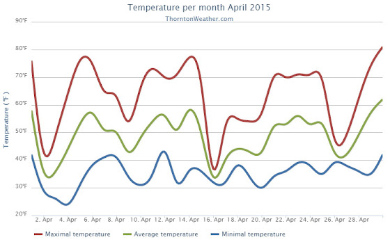
We began the month of April in the need of moisture and while we didn’t do much to bolster our snowfall numbers, rain proved to be a big help. Temperatures were relatively stable but did end up a bit above average.
The first half of the month offered mostly dry conditions and warmer than normal temperatures. The only real exception was a light snowfall on the 2nd and 3rd of the month. Otherwise we saw virtually no precipitation for the first 15 days of April.
The latter half however saw a shift in the weather pattern courtesy of a number of storm systems that moved through. These led to cooler temperatures and some nice shots of precipitation.
A system on the 15th and 16th brought only 3.9 inches of snowfall but a healthy 1.68 inches of liquid precipitation from snowmelt and rain. We then remained mostly dry up until the 26th when another good shot of rain arrived.
Thornton’s average temperature for April 2015 was 49.0 degrees, a good bit above the long term April average of 47.4 degrees. Out at the airport, Denver saw similar readings to ours with an average of 48.7 degrees.
Temperatures in Thornton ranged from a low of 24.0 degrees on the morning of the 4th up to a high of 80.7 degrees on the 30th. Denver’s coldest reading was 27 degrees on the 3rd and its warmest came on the 30th with a temperature of 79 degrees.
In terms of precipitation, Thornton saw 2.68 inches of precipitation for the month. Officially, as measured at DIA, Denver took a very similar 2.65 inches into their bucket. Both readings were a good ways above the April average of 1.71 inches.
Snowfall failed to be anything extraordinary. Both Thornton and Denver saw 5.3 inches of the white stuff, a good bit below the average of 6.8 inches.
Thornton, Colorado temperatur?e summary for April 2015. (ThorntonW?eather.com?)Thornton, Colorado precipitat?ion summary for April 2015. (ThorntonW?eather.com?)
From the National Weather Service:
CLIMATE REPORT
NATIONAL WEATHER SERVICE BOULDER, CO
552 AM MDT FRI MAY 1 2015

...................................

...THE DENVER CO CLIMATE SUMMARY FOR THE MONTH OF APRIL 2015...

CLIMATE NORMAL PERIOD 1981 TO 2010
CLIMATE RECORD PERIOD 1872 TO 2015

WEATHER         OBSERVED          NORMAL  DEPART  LAST YEAR`S
                 VALUE   DATE(S)  VALUE   FROM    VALUE  DATE(S)
                                          NORMAL
................................................................
TEMPERATURE (F)
RECORD
 HIGH              90   04/30/1992
 LOW               -2   04/02/1975
HIGHEST            79   04/30                         80  04/22
LOWEST             27   04/03                         18  04/14
AVG. MAXIMUM     62.1              61.5     0.6     62.8
AVG. MINIMUM     35.3              33.3     2.0     35.2
MEAN             48.7              47.4     1.3     49.0
DAYS MAX >= 90      0               0.0     0.0        0
DAYS MAX <= 32      0               0.3    -0.3        0
DAYS MIN <= 32      7              13.0    -6.0       10
DAYS MIN <= 0       0               0.0     0.0        0
PRECIPITATION (INCHES)
RECORD
 MAXIMUM         8.24   1900
 MINIMUM         0.03   1963
TOTALS           2.65              1.71    0.94     1.24
DAILY AVG.       0.09              0.06    0.03     0.04
DAYS >= .01         9               9.1    -0.1        6
DAYS >= .10         6               4.5     1.5        5
DAYS >= .50         2               0.9     1.1        0
DAYS >= 1.00        1               0.5     0.5        0
GREATEST
 24 HR. TOTAL    1.41   04/16 TO 04/17           04/02 TO 04/03

SNOWFALL (INCHES)
RECORDS
TOTAL            33.8   1933
TOTALS            5.3               6.8

DEGREE_DAYS
HEATING TOTAL     481               529     -48      472
 SINCE 7/1       5205              5731    -526     5730
COOLING TOTAL       0                 1      -1        0
 SINCE 1/1          0                 1      -1        0

FREEZE DATES
RECORD
 EARLIEST     09/08/1962
 LATEST       06/08/2007
EARLIEST                        10/07
LATEST                          05/05
....................................................

WIND (MPH)
AVERAGE WIND SPEED              10.7
HIGHEST WIND SPEED/DIRECTION    41/350    DATE  04/15
HIGHEST GUST SPEED/DIRECTION    52/280    DATE  04/12

SKY COVER
POSSIBLE SUNSHINE (PERCENT)   MM
AVERAGE SKY COVER           0.60
NUMBER OF DAYS FAIR            7
NUMBER OF DAYS PC             16
NUMBER OF DAYS CLOUDY          7

AVERAGE RH (PERCENT)     58

WEATHER CONDITIONS. NUMBER OF DAYS WITH
THUNDERSTORM              6     MIXED PRECIP               0
HEAVY RAIN                2     RAIN                       7
LIGHT RAIN               11     FREEZING RAIN              0
LT FREEZING RAIN          0     HAIL                       1
HEAVY SNOW                1     SNOW                       3
LIGHT SNOW                4     SLEET                      0
FOG                      10     FOG W/VIS <= 1/4 MILE      5
HAZE                      3

-  INDICATES NEGATIVE NUMBERS.
R  INDICATES RECORD WAS SET OR TIED.
MM INDICATES DATA IS MISSING.
T  INDICATES TRACE AMOUNT.
A total lunar eclipse was one of the highlights of April 2015. (Patrick Martin)
April can be a tricky month weather-wise with everything from mild temperatures to snow to severe weather being possible. The good thing about that is that it provides plenty of chances for great photos!
April marks a transition between winter and summer for most of the country but for Denver it is especially true as we can see a stunning variety of weather. The proverbial April showers are certainly a possibility for Denver. Snow? Tornadoes? Thunderstorms? You bet – all can happen!
Throw in our usual wildlife plus the wide variety of birds that return to the Centennial State for the spring and summer and there is a lot going on.
Slideshow updated April 30, 2015. To learn more about how to send your photo to us for inclusion in the slideshow, see below the slideshow.
Showcasing images captured by ThorntonWeather.com readers as well as some of our own, our monthly slideshow covers the entire gamut of weather-related imagery.
Sunsets, sunrises, wildlife and of course every type of weather condition are vividly depicted in images captured from yours and our cameras.
[flickr_set id=”72157649591335084″]
What is missing in the slideshow above? Your photo!
Our monthly photo slideshow is going to feature images that we have taken but more importantly images that you have captured. The photos can be of anything even remotely weather-related.
Landscapes, current conditions, wildlife, pets, kids. Whimsical, newsy, artsy. Taken at the zoo, some other area attraction, a local park, a national park or your backyard. You name it, we want to see and share it!
Images can be taken in Thornton, Denver or anywhere across the extraordinary Centennial State. We’ll even take some from out of state if we can tie it to Colorado somehow.
We’ll keep the criteria very open to interpretation with just about any image eligible to be shown in our slideshows.
What do you win for having your image in our slideshow? We are just a ‘mom and pop’ outfit and make no money from our site so we really don’t have the means to provide prizes. However you will have our undying gratitude and the satisfaction that your images are shared on the most popular website in Thornton.
To share you images with us and get them included in the slideshow just email them to us or share them with ThorntonWeather.com on any of the various social media outlets. Links are provided below.
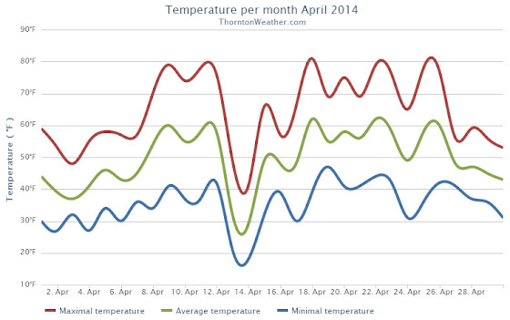
The month of April lacked much in the way of drama for northeastern Colorado. Overall temperatures were warmer than normal and precipitation and snow were lacking a bit.
April started out on the cool side and brought the first snow of the month on the 3rd. By the 8th temperatures had rebounded and we enjoyed a five-day stretch of high temps in the 70s.
A storm system and cold front cooled things down on the 13th and we saw a couple of days of light snowfall. As always the weather bounced back and Thornton recorded its first 80+ degree day of the year on the 18th.
The final four days of the month saw things turn cool again. Some light rain was seen but the bigger story was a period of unusually windy conditions.
Denver’s average April temperature is 47.4 degrees (1981 – 2010). For April 2014, the average temperature in Thornton was more than two degrees higher at 49.6 degrees. Out at Denver International Airport, the average came in a bit cooler at 49.0 degrees.
Temperatures in Thornton ranged from a high of 81.3 degrees on the 18th down to a low of 17.6 degrees on the 14th. DIA saw its warmest reading of 80 degrees on the 22nd and its coldest of 18 degrees on the 14th.
Low temperatures dropped below freezing on 11 days in Thornton. No readings below zero were recorded.
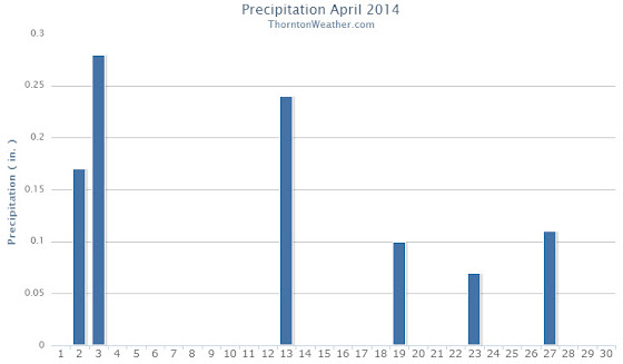
In terms of precipitation, Thornton measured 0.97 inch in the bucket. This is a good ways below the Denver April average of 1.71 inches. DIA saw more precipitation than us with a reading of 1.24 inches.
Similarly, snowfall fell short of normal in Thornton and Denver. On average the Mile High City sees 6.8 inches in April. Thornton recorded only 5.5 inches and DIA 5.6 inches.
April 2014 Temperature Summary for Thornton, Colorado. (ThorntonWeather.com)April 2014 Precipitation Summary for Thornton, Colorado. (ThorntonWeather.com)
CLIMATE REPORT
NATIONAL WEATHER SERVICE BOULDER, CO
603 AM MDT THU MAY 1 2014

...................................

...THE DENVER CO CLIMATE SUMMARY FOR THE MONTH OF APRIL 2014...

CLIMATE NORMAL PERIOD 1981 TO 2010
CLIMATE RECORD PERIOD 1872 TO 2014

WEATHER         OBSERVED          NORMAL  DEPART  LAST YEAR`S
                 VALUE   DATE(S)  VALUE   FROM    VALUE  DATE(S)
                                          NORMAL
................................................................
TEMPERATURE (F)
RECORD
 HIGH              90   04/30/1992
 LOW               -2   04/02/1975
HIGHEST            80   04/22        90     -10       80  04/29
LOWEST             18   04/14        -2      20        6  04/10
AVG. MAXIMUM     62.8              61.5     1.3     54.7
AVG. MINIMUM     35.2              33.3     1.9     28.7
MEAN             49.0              47.4     1.6     41.7
DAYS MAX >= 90      0               0.0     0.0        0
DAYS MAX <= 32      0               0.3    -0.3        4
DAYS MIN <= 32     10              13.0    -3.0       17
DAYS MIN <= 0       0               0.0     0.0        0
PRECIPITATION (INCHES)
RECORD
 MAXIMUM         8.24   1900
 MINIMUM         0.03   1963
TOTALS           1.24              1.71   -0.47     1.87
DAILY AVG.       0.04              0.06   -0.02     0.06
DAYS >= .01         6               9.1    -3.1       13
DAYS >= .10         5               4.5     0.5        7
DAYS >= .50         0               0.9    -0.9        0
DAYS >= 1.00        0               0.5    -0.5        0
GREATEST
 24 HR. TOTAL    0.48   04/02 TO 04/03              0.50
                                                04/22 TO 04/23
SNOWFALL (INCHES)
TOTAL             5.6               6.8

DEGREE_DAYS
HEATING TOTAL     472               529     -57      690
 SINCE 7/1       5730              5731      -1     5802
COOLING TOTAL       0                 1      -1        0
 SINCE 1/1          0                 1      -1        0

FREEZE DATES
RECORD
 EARLIEST     09/08/1962
 LATEST       06/08/2007
EARLIEST                        10/07
LATEST                          05/05
......................................................

WIND (MPH)
AVERAGE WIND SPEED              12.9
RESULTANT WIND SPEED/DIRECTION   2/299
HIGHEST WIND SPEED/DIRECTION    49/340    DATE  04/29
HIGHEST GUST SPEED/DIRECTION    66/340    DATE  04/29

SKY COVER
POSSIBLE SUNSHINE (PERCENT)   MM
AVERAGE SKY COVER           0.70
NUMBER OF DAYS FAIR            1
NUMBER OF DAYS PC             22
NUMBER OF DAYS CLOUDY          7

AVERAGE RH (PERCENT)     50

WEATHER CONDITIONS. NUMBER OF DAYS WITH
THUNDERSTORM              0     MIXED PRECIP               0
HEAVY RAIN                0     RAIN                       3
LIGHT RAIN                8     FREEZING RAIN              0
LT FREEZING RAIN          0     HAIL                       1
HEAVY SNOW                2     SNOW                       3
LIGHT SNOW                6     SLEET                      0
FOG                       8     FOG W/VIS <= 1/4 MILE      2
HAZE                      1

-  INDICATES NEGATIVE NUMBERS.
R  INDICATES RECORD WAS SET OR TIED.
MM INDICATES DATA IS MISSING.
T  INDICATES TRACE AMOUNT.
April 2014 started with blossoming trees. Scroll down for more photos from the month. (LW Inactivist)
April marks a transition between winter and summer for most of the country but for Denver it is especially true as we can see a stunning variety of weather.
The proverbial April showers are certainly a possibility for Denver. Snow? Tornadoes? Thunderstorms? You bet – all can happen!
That stunning variety will undoubtedly be showcased in our monthly photo slideshow (below).
Slideshow updated April 26, 2014
Showcasing images captured by ThorntonWeather.com readers as well as some of our own, our monthly slideshow covers the entire gamut of weather-related imagery. Sunsets, sunrises, wildlife and of course snow are vividly depicted.
Throughout the month we will gather the images sent to us via email or shared with us via our various social media outlets and post them in the slideshow below.
It was sure slow coming with most of the day featuring a light rain / snow mix. At about 4:00pm the snow finally began in earnest. The video below was taken from the ThorntonWeather.com backyard.
April marks a transition between winter and summer for most of the country but for Denver it is especially true as we can see a stunning variety of weather.
The proverbial April showers are certainly a possibility for Denver. Snow? Tornadoes? Thunderstorms? You bet – all can happen!
For good measure throw in a chance for hail and even dust storms and April gives every type of weather condition you could like – or hate.
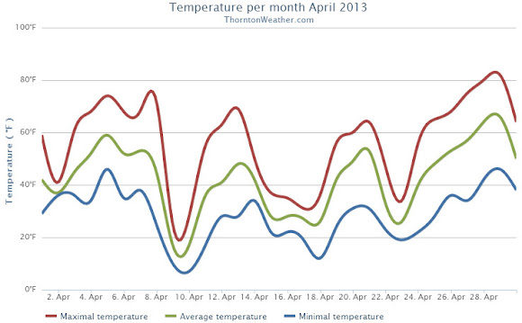
When we look back at April 2013 it will be remembered for two key things: the cold and the snow. By both measurements the month saw extremes with temperatures well below normal and well above normal snowfall, the third month in a row we experienced those conditions.
A series of storm systems moved through during April providing regular doses of cold and snow. Three systems from the 9th of the month through the 25th, each coming at the start of the workweeks, provided the notable conditions. Seventeen of those 18 days saw below normal temperatures.
Denver’s official average temperature for the month came in at 41.7 degrees. This was an impressive 5.7 degrees below the 1981 – 2000 historical average. This put April 2013 into the books as the fifth coldest April since recordkeeping began in Denver. Thornton was only slightly better with an April average temperature of 42.3 degrees.
On four days Denver failed to see high temperatures climb above freezing, Thornton registered three such days.
Five cold temperature records were setting during the month. Record lows were set on April 9th, April 10th and April 22nd. The record low was tied on April 16th. A record low maximum was recorded on the 9th as well.
Temperatures ranged from a high of 80 degrees on the 29th down to a low of 6 degrees on the 10th in Denver. Thornton’s temperatures were similar with a high of 81.7 degrees on the 29th and a low temperature for the month of 6.7 degrees on the 10th.
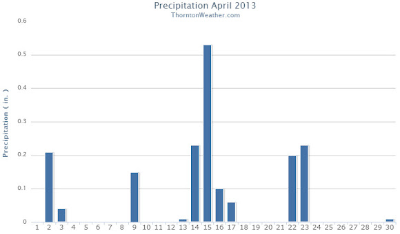
The precipitation was the second half of the April 2013 story with plenty of that falling, primarily in the form of snow.
Denver officially recorded 1.87 inches of liquid precipitation, just a bit above the April average of 1.71 inches. Thornton was just a touch drier with 1.77 inches of precipitation.
Snow was in abundance as Denver saw 20.4 inches of snowfall as measured at Denver International Airport. Thornton was trailing with 19.1 inches. Both marks were well above the Denver April normal of 6.8 inches. Denver’s measurement fell just short of making the list of 10 snowiest Aprils with April 2013 ranking as the 11th snowiest.
Thornton, Colorado April 2013 Temperatures.Thornton, Colorado April 2013 precipitation.
From the National Weather Service:
...THE DENVER CO CLIMATE SUMMARY FOR THE MONTH OF APRIL 2013...

CLIMATE NORMAL PERIOD 1981 TO 2010
CLIMATE RECORD PERIOD 1872 TO 2013

WEATHER         OBSERVED          NORMAL  DEPART  LAST YEAR`S
                 VALUE   DATE(S)  VALUE   FROM    VALUE  DATE(S)
                                          NORMAL
................................................................
TEMPERATURE (F)
RECORD
 HIGH              90   04/30/1992
 LOW               -2   04/02/1975
HIGHEST            80   04/29        83      -3       88  04/24
LOWEST              6   04/10        -2       8       24  04/07
AVG. MAXIMUM     54.7              61.5    -6.8     68.6
AVG. MINIMUM     28.7              33.3    -4.6     37.9
MEAN             41.7              47.4    -5.7     53.3
DAYS MAX >= 90      0               0.0     0.0        0
DAYS MAX <= 32      4               0.3     3.7        0
DAYS MIN <= 32     17              13.0     4.0        4
DAYS MIN <= 0       0               0.0     0.0        0
PRECIPITATION (INCHES)
RECORD
 MAXIMUM         8.24   1900
 MINIMUM         0.03   1963
TOTALS           1.87              1.71    0.16     1.39
DAILY AVG.       0.06              0.06    0.00     0.05
DAYS >= .01        13               9.1     3.9        8
DAYS >= .10         7               4.5     2.5        4
DAYS >= .50         0               0.9    -0.9        0
DAYS >= 1.00        0               0.5    -0.5        0
GREATEST
 24 HR. TOTAL    0.50   04/22 TO 04/23           04/26 TO 04/27

SNOWFALL (INCHES)
RECORDS
 TOTAL           33.8  1933
TOTALS           20.4               6.8

DEGREE_DAYS
HEATING TOTAL     690               529     161      352
 SINCE 7/1       5802              5731      71     5215
COOLING TOTAL       0                 1      -1        6
 SINCE 1/1          0                 1      -1        6

FREEZE DATES
RECORD
 EARLIEST     09/08/1962
 LATEST       06/08/2007
EARLIEST                        10/07
LATEST                          05/05
....................................................

WIND (MPH)
AVERAGE WIND SPEED              11.0
RESULTANT WIND SPEED/DIRECTION   1/016
HIGHEST WIND SPEED/DIRECTION    49/290    DATE  04/14
HIGHEST GUST SPEED/DIRECTION    55/350    DATE  04/08

SKY COVER
POSSIBLE SUNSHINE (PERCENT)   MM
AVERAGE SKY COVER           0.70
NUMBER OF DAYS FAIR            2
NUMBER OF DAYS PC             20
NUMBER OF DAYS CLOUDY          8

AVERAGE RH (PERCENT)     53

WEATHER CONDITIONS. NUMBER OF DAYS WITH
THUNDERSTORM              1     MIXED PRECIP               0
HEAVY RAIN                1     RAIN                       3
LIGHT RAIN               10     FREEZING RAIN              0
LT FREEZING RAIN          0     HAIL                       0
HEAVY SNOW                3     SNOW                       6
LIGHT SNOW                8     SLEET                      0
FOG                      12     FOG W/VIS <= 1/4 MILE      5
HAZE                     11

-  INDICATES NEGATIVE NUMBERS.
R  INDICATES RECORD WAS SET OR TIED.
MM INDICATES DATA IS MISSING.
T  INDICATES TRACE AMOUNT.
Weather, natural disasters & climate news and information.
 April marks a transition between winter and summer for most of the country but for Denver it is especially true as we can see a stunning variety of weather.