![]() Klaus Wolter, a meteorologist affiliated with the University of Colorado and the National Oceanic and Atmospheric Administration continues to promise a dry winter. In an article today in the Rocky Mountain News he says, “I think we should count our blessings. We got lucky” in regards to the amount of moisture the state has seen thus far.
Klaus Wolter, a meteorologist affiliated with the University of Colorado and the National Oceanic and Atmospheric Administration continues to promise a dry winter. In an article today in the Rocky Mountain News he says, “I think we should count our blessings. We got lucky” in regards to the amount of moisture the state has seen thus far.
According to Wolter, the La Nina weather pattern present in the Pacific will persist resulting in storms tracking north of our state. The good news though is that snowpack thus far is above normal statewide and even if their predictions bear out, we should be okay come summer. Here are the latest readings as of today:
           S N O W  -  P R E C I P I T A T I O N    U P D A T E

              Based on Mountain Data from NRCS SNOTEL Sites
                    As of MONDAY: JANUARY 14 , 2008
-----------------------------------------------------------------------------
STATE                                                      PERCENT OF AVERAGE
  RIVER BASIN                                     Number   Snow Water  Accum
                                                 of Sites  Equivalent  Precip
-----------------------------------------------------------------------------
COLORADO
  GUNNISON RIVER BASIN ......................... 11 of 13     144       137
  UPPER COLORADO RIVER BASIN ................... 27 of 29     119       124
  SOUTH PLATTE RIVER BASIN ..................... 15 of 15     105       101
  LARAMIE AND NORTH PLATTE RIVER BASINS ........ 13 of 13     101       109
  YAMPA AND WHITE RIVER BASINS ................. 17 of 19     102       111
  ARKANSAS RIVER BASIN .........................  5 of  9     141       124
  UPPER RIO GRANDE BASIN .......................  9 of 13     158       144
  SAN MIGUEL, DOLORES, ANIMAS
     AND SAN JUAN RIVER BASINS ................. 14 of 16     153       135
We of course hope the forecasters are wrong just like they have been about the last two hurricane seasons!

 Recent snows along with high winds have raised the avalanche danger in the high country to “considerable” in many areas according to the
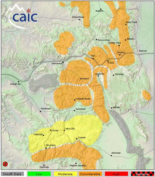
 As we finish what has been a relatively wet December, cold and dry are the key words to remember when it comes to January. The month is the coldest of the year and the second driest as well. What does history show us and what can we expect for January 2008?