Thornton 8 is now available for live, online streaming on the city’s website and ThorntonWeather.com. (City of Thornton)
The City of Thornton’s KTTV-8 television channel can be a great resource for information as to what is going on in our fine city. Unfortunately watching the channel required you subscribed to Comcast cable – until now.
We were browsing the city’s website today and noticed they have added a live Internet feed of the channel. This is a great development and one that allows all Thornton residents with Internet access to view the station and get the latest city news and information.
Alternatively, we have added a page on our website where you can watch the live feed. You will find it under the ‘Area Information’ button to the left or click here to view it.
Please note: ThorntonWeather.com is not endorsed by or an official website of the City of Thornton.
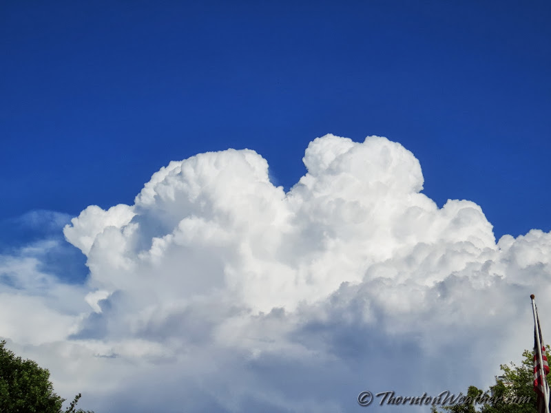
A view of the thunderstorm on Saturday, July 20, 2013 after it passed Thornton. View more imagery in the slideshow below. (ThorntonWeather.com)
The forecast called for a chance for thunderstorms and Mother Nature obliged on Saturday. Heavy rain and gusty winds struck the north metro area but what followed was perhaps more interesting.
In all, Thornton recorded 0.29” of rain in a very short period from 4:30 to 4:55pm. Some small hail accompanied the storm as did strong wind gusts. There were some reports of broken tree limbs from the powerful gusts.
After the storm moved to the southeast, it continued to intensify. From almost any vantage point in Thornton, the scene was amazing.
Initially the bright while tops of the storm cells were stark and beautiful to watch. A nearly full moon then began to rise in the east behind the storms and the scene was stunning. As the sun went down, the clouds turned a shade of amber providing a colorful scene with the rising moon.
The slideshow below has a nice little compilation of image taken by ThorntonWeather.com and some of our fans on Facebook.
Colorado lived up to its ranking as one of the most dangerous states in the union for lightning as 13 people were injured by bolts on Thursday. Afternoon thunderstorms unleashed the flashes causing the injuries across three locations. Read the rest of this story on Examiner.com
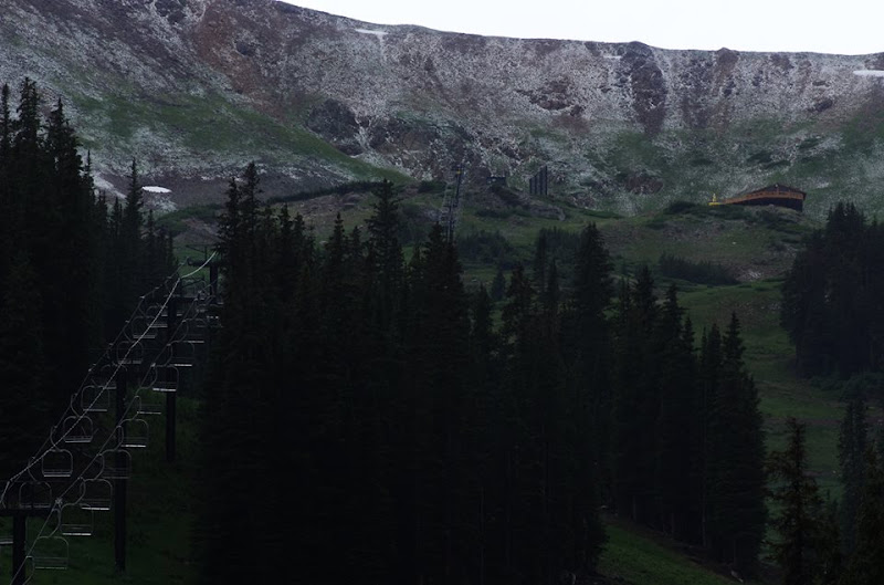
July 18, 2013 – Loveland Ski Area received a dusting of snow. While a bit unusual in mid-summer, certainly not unheard of given an altitude at the base of 10,800 feet. (Loveland Ski Area)
At an altitude of 10,800 feet, Loveland Ski Area is certainly in some rarified air. Yesterday the resort saw a dusting of snow while Colorado residents below in the Mile High City simmered in 90+ degree temperatures.
Snowfall can occur in Colorado’s high country any time of year, even in mid-summer, and yesterday’s event was not particularly unusual.
Here in Denver however there has never officially been snow in July. The key word though is ‘officially.’
Unofficially there has been snow in the Mile High City in July – almost exactly one year ago today in fact.
Check out this tidbit from the National Weather Service archives:
“On July 17, 1872…the U.S. Army Signal Service weather observer recorded snowfall during the early morning hours in the hand written daily weather journal: “rain commenced at 1:30 a.m. changing about 3 a.m. to snow & in about half an hour to rain again; it continued until 6 a.m.” This is the only recorded occurrence of snowfall in Denver in July…but this report is not included in the “official” station snowfall records…which did not begin in Denver until January 1…1882. The low temperature on this morning was 45 degrees…which is sufficiently cold for the occurrence of light stratiform snowfall.”
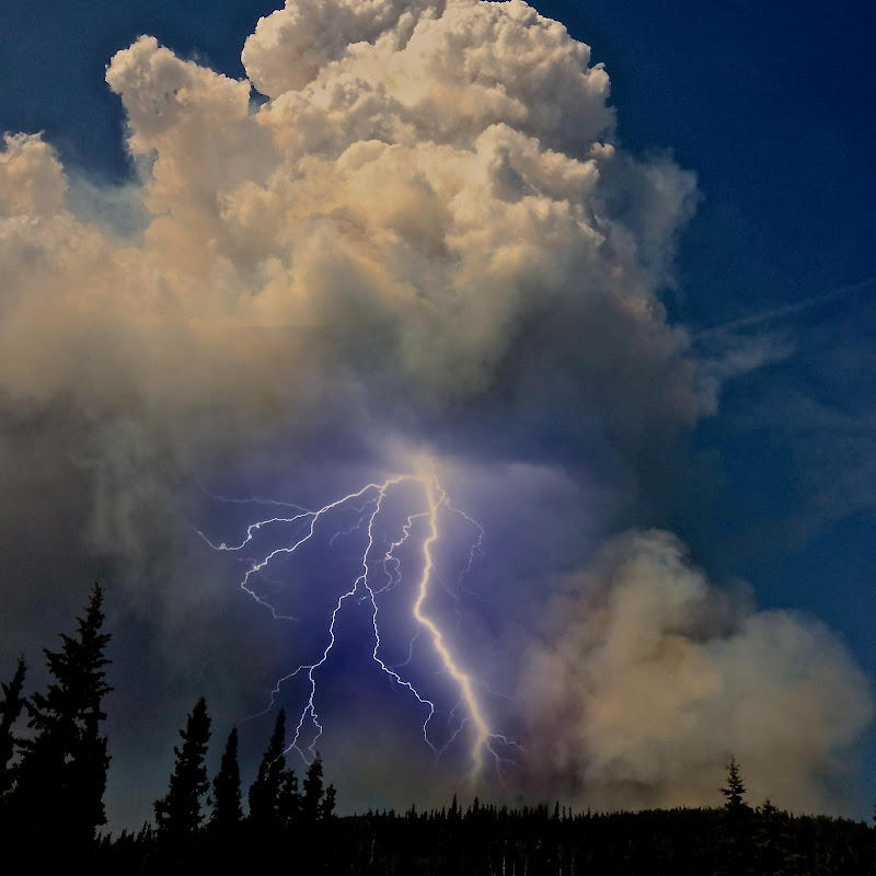
Weather of course clearly affects wildfires but fires themselves can literally create their own weather. One such phenomena are pyrocumulus clouds and a photo from a wildfire in Alaska provides a stunning example.
Pyrocumulus clouds are formed by fires or volcanos when the intense heat from the event rises from the surface. These clouds oftentimes look like dirty thunderstorm clouds directly over a blaze and can give rise to thunderstorm-like weather conditions.
Lightning from these clouds can occur and in particular when coupled with a volcanic eruption are absolutely amazing. With wildfires, the strong winds and lightning can result in dangerous and unpredictable expansion of a fire.
The Moon Lake Complex Fire is currently burning in eastern Alaska and has scorched over 18,000 acres. Inciweb posted a photo of a pyrocumulus cloud over the blaze near Tok that let loose a stunning bolt of lightning.
June 2, 2013 – A pyrocumulus cloud above the Moon Lake Complex Fire in Alaska unleashes a lightning bolt. (Inciweb)
In writing the history of the weather for the area for June 2013 two words come to mind: hot and dry. While both conditions were certainly prevalent, we can at least be consoled by the fact that it could have been worse.
The month actually started cooler than normal with six of the first seven days recording below average temperatures. Soon though high pressure built over the area and temperatures began to climb with many days for the balance seeing above normal mercury readings.
June 2013 wrapped up with an average temperature in Thornton of 70.5 degrees. This was well above Denver’s historical average for the month of 67.4 degrees. Officially Denver’s average temperature last month was 71.1 degrees, warm enough to put it in a tie for the 10th warmest June in Denver history.
In all, Thornton recorded 10 days with mercury readings above 90 degrees. Denver saw 14.
The warmest temperature of the month in Thornton was 99.2 degrees on the 11th. That same day Denver hit 100 degrees, its high reading of the month.
Thornton’s coldest temperature came on the 6th when the temperature dropped to 41.6 degrees. Denver’s officially bested that with a low temperature for the month of 39 degrees on the 2nd.
Denver officially broke three temperature records during the month:
In terms of precipitation the month was certainly dry but not the worst we have seen. Thornton recorded a scant 0.49 inch in the rain bucket. Denver bested us slightly by recording 0.75 inches. Both measurements were far below the 1.98 inch historical average for June but certainly better than the driest June on record in 1890 when only a trace was recorded.
Thornton, Colorado June 2013 Temperatures.Thornton, Colorado June 2013 Precipitation.
CLIMATE REPORT
NATIONAL WEATHER SERVICE BOULDER, CO
210 AM MDT MON JUL 1 2013

...................................

...THE DENVER CO CLIMATE SUMMARY FOR THE MONTH OF JUNE 2013...

CLIMATE NORMAL PERIOD 1981 TO 2010
CLIMATE RECORD PERIOD 1872 TO 2013

WEATHER         OBSERVED          NORMAL  DEPART  LAST YEAR`S
                 VALUE   DATE(S)  VALUE   FROM    VALUE  DATE(S)
                                          NORMAL
................................................................
TEMPERATURE (F)
RECORD
 HIGH             105   06/26/2012
                        06/25/2012
                        54/01/2206
 LOW               30   06/02/1951
HIGHEST           100   06/11       104      -4      105  06/26
                                                          06/25
LOWEST             39   06/02        30       9       43  06/11
AVG. MAXIMUM     87.8              82.4     5.4     91.7
AVG. MINIMUM     54.3              52.3     2.0     58.4
MEAN             71.1              67.4     3.7     75.0
DAYS MAX >= 90     14               7.9     6.1       17
DAYS MAX <= 32      0               0.0     0.0        0
DAYS MIN <= 32      0               0.0     0.0        0
DAYS MIN <= 0       0               0.0     0.0        0

PRECIPITATION (INCHES)
RECORD
 MAXIMUM         4.96   1882
 MINIMUM            T   1890
TOTALS           0.75              1.98   -1.23     1.22
DAILY AVG.       0.03              0.07   -0.04     0.04
DAYS >= .01         4               8.4    -4.4        2
DAYS >= .10         2               4.6    -2.6        2
DAYS >= .50         1               1.4    -0.4        2
DAYS >= 1.00        0               0.3    -0.3        0
GREATEST
 24 HR. TOTAL    0.51   06/23 TO 06/23           06/06 TO 06/07
                        06/22 TO 06/23                    06/23 TO 06/23
                        06/23 TO 06/23                    06/23 TO 06/23
 STORM TOTAL       MM                                 MM
 (MM/DD(HH))            MM                    06/07(00) TO 06/07(00)
                                                 06/23(00) TO 06/23(00)3
                                                 06/23(00) TO 06/23(00)3

SNOWFALL (INCHES)
RECORDS
 TOTAL             MM   MM
TOTALS            0.0               0.0

DEGREE_DAYS
HEATING TOTAL      29                62     -33        6
 SINCE 7/1       6084              6058      26     5399
COOLING TOTAL     221               133      88      314
 SINCE 1/1        263               155     108      365

FREEZE DATES
RECORD
 EARLIEST     09/08/1962
 LATEST       06/08/2007
EARLIEST      03/01             10/07
LATEST        04/24             05/05
....................................................

WIND (MPH)
AVERAGE WIND SPEED              10.7
RESULTANT WIND SPEED/DIRECTION   2/156
HIGHEST WIND SPEED/DIRECTION    64/060    DATE  06/18
HIGHEST GUST SPEED/DIRECTION    97/040    DATE  06/18

SKY COVER
POSSIBLE SUNSHINE (PERCENT)   MM
AVERAGE SKY COVER           0.50
NUMBER OF DAYS FAIR            6
NUMBER OF DAYS PC             23
NUMBER OF DAYS CLOUDY          1

AVERAGE RH (PERCENT)     42

WEATHER CONDITIONS. NUMBER OF DAYS WITH
THUNDERSTORM              0     MIXED PRECIP               0
HEAVY RAIN                3     RAIN                       2
LIGHT RAIN                7     FREEZING RAIN              0
LT FREEZING RAIN          0     HAIL                       0
HEAVY SNOW                0     SNOW                       0
LIGHT SNOW                0     SLEET                      0
FOG                       4     FOG W/VIS <= 1/4 MILE      0
HAZE                      6

-  INDICATES NEGATIVE NUMBERS.
R  INDICATES RECORD WAS SET OR TIED.
MM INDICATES DATA IS MISSING.
T  INDICATES TRACE AMOUNT.
Fireworks are illegal in Thornton and with the tinder dry conditions this year, fire danger is extraordinarily high. Please leave the show to the pros!
Fireworks have long been illegal in the City of Thornton and in recent years stiff fines have been meted out to violators. Like last year, conditions are tinder dry and as such it is especially important that residents adhere to the law and leave the show to the pros.
Wildfires are burning across Colorado right now with tens of thousands of acres charred and more than 500 homes destroyed. These events highlight that even a small spark in the dry conditions we are experiencing could lead to disaster.
The danger is there, even in an urban environment, where foliage is very dry, lawns are parched and building materials are completely dried out. While residents could still go to Wyoming or unincorporated areas of Adams County to purchase them, the risk is simply not worth the minimal reward.
Not too many of us have an extra $500 lying around and that is what it will cost anyone who shoots off fireworks in Thornton. A second violation in 12 months nets you a $1,000 fine. Of course violators will also have to deal with the disdain of neighbors who likely do not appreciate the noise, mess, smoke, hassle and danger you present to their property.
Rather than spend money on fireworks – and fines – do something good with your money. Donate to Help Colorado Now, an organization sponsored by the state of Colorado dedicated to helping relief organizations assisting communities hit by disaster. Show your support for our fellow Coloradans and leave the show to the pros.
With the landscape tinder dry and conditions ripe for wildfires, Adams County has announced a burn ban in all unincorporated areas. Effective immediately, absolutely no open burning is allowed.
[Adams County Sheriff’s Sgt. Paul] Gregory said the fire ban did not apply to fires within liquid fuels or gas stoves, fireplaces inside buildings and charcoal or propane grill fires at private residences. Fires within permanent fire grates in developed campgrounds are OK. So is burning household trash within a fireproof container that won’t let flame or burning material escape from the bottom of the container. Gregory said the container has to be in the center of an area that is 10 feet in diameter “from which all flammable material has been removed.”
The ban only applies to unincorporated areas of the county so is not applicable to Thornton residents within city limits. Click the image below for a look at the restrictions. To date we have not seen any fire ban ordered by the City of Thornton.
As the sun went down yesterday a thunderstorm moved over the Thornton area. It provided some brief, heavy rain which was very welcome given our drought stricken landscape. Accompanying the moisture was a good bit of lightning which lit up the post-sunset sky.
Our west facing webcam captured one bolt as it struck turning night into day for a brief instant.
A thunderstorm on June 23, 2013 delivered rain and a good bit of lightning. ThorntonWeather.com’s west facing camera happened to capture one bolt as it struck.
Weather, natural disasters & climate news and information.