This morning 20 million subscribers to DirecTV found The Weather Channel missing from their viewing options. The weather network has cited its need to sound the manmade climate change alarm as one of the reasons it needs to be…

Read the rest of this story on Examiner.com
Weather Channel goes dark on DirecTV, other weather networks ready to jump in

Following a contentious dispute with satellite television provider DirecTV, The Weather Channel went dark on the service at midnight Monday. The loss of the network however has allowed other true weather networks an opportunity to provide news and information to the public.
The loss is the first major outage for The Weather Channel that brought 24 / 7 weather to Americans’ homes but has since given up on its core mission in favor of reality based television shows.
It is that shift in programming choices and the lack of true weather coverage that DirecTV cited in its decision to drop the network.
Helmet cam captures motorcycle rider trying to cross Colorado floodwaters

September 2013 went into the history books as one of the most disastrous in Colorado history as torrential rains brought devastating flooding. Most residents heeded warnings meant to save lives but newly discovered video showcases one man ignoring them and nearly drowning in the process.
The video, released by action camera maker GoPro last week, features motorcycle rider Michael Henao attempting to cross flooded Colorado roadways near Boulder. The results were nearly deadly.
Shown from his helmet-mounted camera, Henao starts on on mud-covered roads but then continues on what is clearly a closed road. Water that initially appears calm gets deeper and runs faster as he rides further into the floodwaters.
Read the rest of this story and watch the amazing video on Examiner.com
White House: ‘Polar vortex’ cold likely linked to manmade climate change

Amid the record-setting cold being seen across much of the United States, the White House dispatched one of its top science officials to try to convince Americans that global warming is occurring and may in fact be responsible for the cold.
In a video published to the White House’s website and YouTube yesterday, Dr. John Holdren, President Barack Obama’s science advisor says, “If you’ve been hearing that extreme cold spells, like the one we’re having in the United States now, disproves global warming, don’t believe it.”
Scientists however have been struggling to explain the lack of ‘extreme weather’ or increasing temperatures. Alarmists seem to want to tie any type of event to manmade climate change now.
Read the rest of this story and watch the video on Examiner.com
Video captures chain reaction multi-car crash on I-25 near Colorado Springs

As temperatures dropped and the snow fell Saturday across Colorado, roads became ice-coated and driving conditions worsened. Video captured near Colorado Springs captured a harrowing multi-car pileup on Interstate 25 that highlighted the dangerous road conditions.
Posted by a user Anthony Salazar to KOAA-5 television’s Facebook page, the video is taken from an overpass in the Colorado Springs area on Saturday, January 4.
Showing I-25 southbound, some drivers are shown exercising appropriate caution on the icy roads and proceeding slowly. Calamity ensues when others are less aware of the conditions.
Read the rest of this story and check out the amazing video on Examiner.com
Announcing the ThorntonWeather.com monthly photo slideshow
From stunning sunsets and impressive storms to cute snow-covered dogs and amazing wildlife, Coloradans witness amazing things every day. Starting today ThorntonWeather.com begins a new feature showcasing the imagery captured by cameras and we want YOUR pictures to share with others.
Colorado’s weather is anything but boring and virtually every day we are greeted with wonders large and small. Even in the quietest of weather conditions, the views of our landscape are stunningly varied from the vast plains to the east through the urban corridor of Denver and Thornton to the massive peaks towering over 14,000 feet high.
We all love our state and the wonders we see every day. ThorntonWeather.com wants to share what you see with others.
- Our first monthly slideshow has been posted. Click here to view the images for January 2014 (so far)
Our monthly photo slideshow is going to feature images that we have taken but more importantly images that you have captured. The photos can be of anything even remotely weather-related.
Landscapes, current conditions, wildlife, pets, kids. Whimsical, newsy, artsy. Taken at the zoo, some other area attraction, a local park, a national park or your backyard. You name it, we want to see and share it!
Images can be taken in Thornton, Denver or anywhere across the extraordinary Centennial State. We’ll even take some from out of state if we can tie it to Colorado somehow.
We’ll keep the criteria very open to interpretation with just about any image eligible to be shown in our slideshows.
What do you win for having your image in our slideshow? We are just a ‘mom and pop’ outfit and make no money from our site so we really don’t have the means to provide prizes. However you will have our undying gratitude and the satisfaction that your images are shared on the most popular website in Thornton.
To share you images with us and get them included in the slideshow just email them to us or share them with ThorntonWeather.com on any of the various social media outlets. Links are provided below.
So come on, get those camera’s rolling!
- Email: info@ThorntonWeather.com
- Facebook: https://www.facebook.com/ThorntonWeather
- Google+: https://plus.google.com/+Thorntonweather
- Twitter: @ThorntonWeather (https://twitter.com/thorntonweather)
U.S. Coast Guard deployed to rescue global warming expedition and its rescuers

A Russian research ship stuck in expanding Antarctic ice and a Chinese ice breaker sent to help have put out calls for further assistance and the U.S. Coast Guard is responding.
The Akadmik Shokalskiy became stuck in the ice on December 24. Tourists, scientists and journalists were on board the Russian ship conducting global warming research.
Chinese icebreaker Xue Long was dispatched to rescue the trapped researchers. Using its helicopters it was able to airlift dozens of passengers to a second rescue ship, the Aurora Australis, on Thursday. However, the Xue Long soon found itself stuck in the expanding ice.
Last week the Australian government asked the United States for assistance in clearing the way for the two ships and yesterday it was announced the U.S. Coast Guard would dispatch one of its largest ships to help.
Read more about the rescue mission – with video – on Examiner.com
2013 Thornton weather recap: Numbers show a cooler and wetter than normal year
 Another year is in the books and as we look back at 2013’s weather, we see Thornton – and indeed much of the state – saw cooler and wetter than normal conditions.
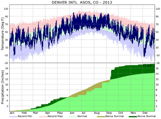
In terms of temperatures, Thornton saw an average overall annual temperature of 49.3 degrees. Out at Denver International Airport where the Mile High City’s official records are kept, the average was warmer at 50.1 degrees. By comparison, Denver’s 1981 to 2010 annual average temperature is 50.4 degrees.
Thornton recorded 47 days with temperatures at or above the 90 degree mark. At DIA 54 such days were recorded. Both were above the average of 40 90 degree days per year.
The hottest temperature recorded during the year in Thornton came on June 11th when the mercury climbed to 99.2 degrees. Denver’s hottest temperature of 100 degrees came on June 11th and July 11th.
At the opposite end of the thermometer, Thornton saw 175 days with low temperatures below freezing. Denver was very similar with 169 days with temperatures below 32 degrees. On average we expect to see 157 days below freezing.
Our coldest temperature in Thornton came last month on December 5th when the mercury dropped to -9.3 degrees. Denver’s occurred on the same date as the mercury at the airport dropped to -15 degrees.
- Must see photos – Top Shots 2013: ThorntonWeather.com’s top photos of the year
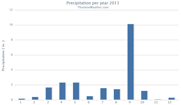
Precipitation for 2013 came in well above normal thanks largely in part to the extraordinary amount of rain received in September.
In all, Thornton saw 21.67 inches of liquid precipitation in our bucket. Denver, as always drier due to the station being at DIA, saw 17.60 inches. Both were above the annual average of 14.92 inches.
Above and by far the wettest month of the year was September and was responsible for the above average precipitation numbers. Thornton saw 10.15 inches in the rain bucket that month alone, Denver 5.61 inches.
Snowfall during the calendar year ended up relatively strong thanks to healthy totals from February through April. Overall the rest of the months of the year saw below normal snowfall.
Thornton’s annual snow total came in at an even 70.0 inches. Denver bested us with 74.1 inches during 2013.
Denver’s 2013 / 2014 season however has started out dismally with only 8.1 inches so far in the Mile High City. Thornton ended December a bit better with 10.8 inches. Both are well below the long term average that would have us see 21.2 inches by the end of the year.
Click here to view Thornton’s 2013 climate summary.

CLIMATE REPORT
NATIONAL WEATHER SERVICE BOULDER, CO
427 PM MST WED JAN 1 2014

...................................

...THE DENVER CO CLIMATE SUMMARY FOR THE YEAR OF 2013...

CLIMATE NORMAL PERIOD 1981 TO 2010
CLIMATE RECORD PERIOD 1872 TO 2013

WEATHER         OBSERVED          NORMAL  DEPART  LAST YEAR`S
                 VALUE   DATE(S)  VALUE   FROM    VALUE  DATE(S)
                                          NORMAL
................................................................
TEMPERATURE (F)
RECORD
 HIGH             105   06/26/2012
                        06/25/2012
                        07/20/2005
 LOW              -29   01/09/1875
HIGHEST           100   07/11        64      36      105  06/26
                        06/11                             06/25
LOWEST            -15   12/05        36     -51       -6  01/11
AVG. MAXIMUM     63.9              64.7    -0.8     68.4
AVG. MINIMUM     36.3              36.3     0.0     39.3
MEAN             50.1              50.5    -0.4     53.9
DAYS MAX >= 90     54              39.6    14.4       73
DAYS MAX <= 32     29              20.0     9.0       19
DAYS MIN <= 32    169             156.9    12.1      132
DAYS MIN <= 0      11               5.8     5.2        4

PRECIPITATION (INCHES)
RECORD
 MAXIMUM        23.31   1967
 MINIMUM         7.29   2008
TOTALS          17.60             14.30    3.30    10.11
DAILY AVG.       0.05              0.03    0.02     0.03
DAYS >= .01        82              79.7     2.3       52
DAYS >= .10        42              34.9     7.1       23
DAYS >= .50         8               7.6     0.4        9
DAYS >= 1.00        3               2.3     0.7        1
GREATEST
 24 HR. TOTAL    2.39   09/13 TO 09/14

 STORM TOTAL     4.65   09/09 TO 09/15

SNOWFALL (INCHES) RECORDS
TOTAL          115.9   1913
24 HR TOTAL     23.6   12/24/1982 TO 12/24/1982
SNOW DEPTH        MM   MM
TOTALS           72.1              53.8    18.3     38.5
 LIQUID EQUIV    5.40              5.40      MM     3.85
SINCE 7/1         8.1              22.5   -14.4     12.4
 LIQUID 7/1      0.81              2.20   -1.39     1.24
SNOWDEPTH AVG.      0                MM      MM        0
DAYS >= TRACE      60              33.3    26.7       36
DAYS >= 1.0        20              16.3     3.7       13
GREATEST
 SNOW DEPTH         9   02/25                         11  02/04
 24 HR TOTAL      9.1   02/24 TO 02/24              12.5  03/03
 STORM TOTAL     11.7   03/22 TO 03/24              15.9  03/02
                                                          03/04

DEGREE_DAYS
HEATING TOTAL    6302              6059     243     5198
 SINCE 7/1       2451              2468     -17     2233
COOLING TOTAL     999               769     230     1236
 SINCE 1/1        999               769     230     1236

FREEZE DATES
RECORD
 EARLIEST     09/08/1962
 LATEST       06/08/2007
EARLIEST                        10/07
LATEST                          05/05
..................................................

WIND (MPH)
AVERAGE WIND SPEED              9.7
RESULTANT WIND SPEED/DIRECTION   2/201
HIGHEST WIND SPEED/DIRECTION    64/060    DATE  06/18
HIGHEST GUST SPEED/DIRECTION    97/040    DATE  06/18

SKY COVER
POSSIBLE SUNSHINE (PERCENT)   MM
AVERAGE SKY COVER           0.60
NUMBER OF DAYS FAIR           69
NUMBER OF DAYS PC            232
NUMBER OF DAYS CLOUDY         64

AVERAGE RH (PERCENT)     52

WEATHER CONDITIONS. NUMBER OF DAYS WITH
THUNDERSTORM              0     MIXED PRECIP               0
HEAVY RAIN               14     RAIN                      25
LIGHT RAIN               80     FREEZING RAIN              0
LT FREEZING RAIN          4     HAIL                       0
HEAVY SNOW               11     SNOW                      23
LIGHT SNOW               58     SLEET                      0
FOG                     105     FOG W/VIS <= 1/4 MILE     33
HAZE                     88

-  INDICATES NEGATIVE NUMBERS.
R  INDICATES RECORD WAS SET OR TIED.
MM INDICATES DATA IS MISSING.
T  INDICATES TRACE AMOUNT.
Thornton’s January weather preview: Usually a cold month but not always snowy
 As we begin the new year the winter chill begins to set in. While January can see its share of extremes, the month historically sees stable temperatures and is usually relatively dry.
January ranks as the second coldest month in Denver next to December with average temperatures remaining virtually the same from the start to the end of the month. In terms of snowfall, the month only ranks as the fourth snowiest and it is not uncommon for it to be quite dry.
What does January 2013 hold for us? Indications are that we may very well continue the recent pattern of below normal temperatures and relatively dry conditions.
For the complete January preview including a look at historical averages and extremes, click here.
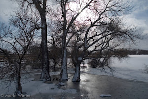
Top Shots 2013: ThorntonWeather.com’s top photos of the year
Colorado’s weather and scenery can certainly be dramatic and the past year has been no different. Armed with our camera, we captured hundreds of images and shared them with our readers.
While we are entirely amateur photographers, sometimes Colorado makes it hard to take a bad picture. Over the course of 2013 we took hundreds of photos, many of which were shared with you on Facebook, Google+ and Twitter.
Picking which of the images we liked the best was not easy. The subject matter ranged from weather to wildlife to expansive landscapes and even heavenly bodies.
As we sorted through we couldn’t help but notice the lack of real weather drama in the photos we took. While there were wildfires to our south and floods to the north, Thornton managed to escape the year relatively unscathed from Mother Nature’s wrath.
We also were unable to do any real storm chasing so severe weather imagery was lacking. Hopefully that can be rectified in 2014. 😉
When all was said and done we came up with 25 images that we thought were our best photos of the year. You can view them in the slideshow below. Leave a comment here or on our social media pages and let us know what you think.
Remember too that we love seeing your photos so be sure to share them with us!