Colorado’s famously inconsistent weather appears to be on full display this month. Just two weeks ago we were setting records for cold. Today we broke a record high temperature and tied the record high minimum.
At 12:59 p.m. the temperature at Denver International Airport reached 68 degrees. This broke the old record high temperature for December 18 of 66 degrees last set in 1979.
Additionally, Denver’s low temperature was 40 degrees. This tied the record low maximum for the date set in 1917.
The average high for December 18 is 42 degrees and the average low is 17 degrees.
Here in Thornton we were just slightly cooler as the mercury here topped out at 67 degrees at 12:44 p.m. Our low dropped to 39 degrees.
An Ultra Orthodox Jewish man walks in the snow in Jerusalem, Israel. Click to view a slideshow of the event. (Getty Images)
A powerful winter storm system struck parts of the Middle East on Friday to the delight of some residents but causing havoc in other locations where snow is a rarity.
In Cairo, Egypt snow fell, reportedly for the first time in 112 years, covering parts of the city in a light blanket of white.
Parts of Israel saw heavy snow totaling up to three feet. Jerusalem Mayor Nir Barkat told The Times of Israel, “We’re facing a rare storm the likes of which we’ve never seen.”
The local meteorological agency said it was the worst snowstorm seen since at least 1953.
Screenshot of a video showing four angles just as a tornado strikes Washington, Illinois on November 17, 2013. (YouTube)
Last month a tornado outbreak visited death and destruction across multiple states in the nation’s midsection. Security camera footage just release by a homeowner in Illinois whose house was destroyed captures the destruction as it happens.
Over 100 tornadoes spanning seven states were reported on November 17. While the actual number of twisters was likely lower due to duplicates, it was an extraordinary tornado outbreak, particularly given how late in the year it occurred.
The tornado that struck Washington, IL on that fateful day has been determined to be an EF-4 on the Enhanced Fujita Scale.
This week a YouTube user by the name of ‘athlon770’ released security camera footage of the event.
From four different cameras , the video shows exterior views as the tornado approaches and the wind starts throwing debris. In the climax, the inside of the home virtually explodes as it takes a direct strike from the twister.
Following the video, the user adds still photos of the aftermath. It is truly a devastating scene.
In a video from Greenpeace, global warming has taken its toll on Santa Claus and the North Pole.
Global warming has prompted Santa Claus to issue an urgent appeal to children to help save his home in the Arctic. In a new video from the radical environmental group Greenpeace, the jolly old elf hardly looks like himself as he announces, “I bring bad tidings.”
With labored breaths, Santa says, “For some time now melting ice, here, at the North Pole has made our operations and our day to day life intolerable and impossible and there may be no alternative but to cancel Christmas.”
The timing of Greenpeace’s video is arguably not the best.
The Arctic sea ice minimum, reached in September, saw a 49% increase over the previous year. That represents an increase of 653,000 square miles giving Santa and the reindeer quite a bit more snow and ice to play on and use to prepare for Christmas.
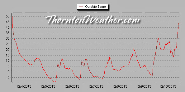
Thornton, Colorado temperatures during the December 2013 cold spell.
Thornton’s December 2013 Arctic blast has come to an end as the mercury finally climbed above freezing today. For nearly seven straight days we saw temperatures below 32 degrees.
Soon after noon on Tuesday, December 3 the cold front arrived along the Colorado Front Range. The mercury would plummet quickly from a high that day of 55.9 degrees and drop below freezing at 1:56 p.m.
It wasn’t until 9:12 a.m. this morning when the temperature finally climbed above 32 degrees, the rising temperatures being pushed higher by Chinook winds. In all, sub-freezing temperatures were recorded for 6 days, 19 hours and 16 minutes straight.
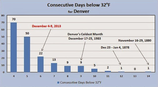
Looking at how the event ranks in comparison to historical Denver cold spells, it falls short of making the list of top 10 longest periods with maximum temperatures below freezing.
Number 10 on the list is a nine day streak that ended on December 25, 1983. The top spot goes to a 14 day period that ended on November 29, 1880.
Snowfall was relatively minimal however as is often the case when temperatures drop so far. Thornton measured 2.4 inches and Denver 3.1 inches.
The table below shows the high and low temperatures for Thornton and Denver during the cold spell.
Date
Thornton High
Thornton Low
Denver High
Denver Low
12/3/13
55.9
11.4
56
11
12/4/13
12.3
-4.3
11
-13 *
12/5/13
12.2
-9.3
8
-15 *
12/6/13
12.3
-6.8
8
-13
12/7/13
13.9
-6.6
9
-11
12/8/13
20.9
1.8
17
-5
12/9/13
30.5
-3.8
25
-4
12/10/13
46.9
13.2
* Record low temperatures
Denver, Colorado sub-freezing temperature streaks. (National Weather Service)
The minimum temperature at Denver International Airport dropped below zero for six consecutive days from December 4th through December 9th 2013. The longest consecutive stretch of below zero low temperatures occurred back in December of 1972. Click for a larger view. (National Weather Service)
Much of the nation’s mid-section was plunged into a deep freeze this past week with temperatures registering below zero in many locations. On the west coast where the weather is rarely dramatic, Los Angeles TV stations played up their version of ‘cold’ and late-night TV host Jimmy Kimmel made fun of them.
“Southern California is getting a bitter blast of cold weather this morning,” one news anchor proclaimed.
More hardy residents in other parts of the nation undoubtedly laughed at the attire of In-the-field reporters. While trying to hype the cold, reporters wore heavy coats, scarves and gloves to battle those cold 50 degree temperatures.
Weather Geek Stuff is a great place to shop for gifts for weather enthusiasts, weather geeks and weather lovers.
Not everyone gets excited about blizzards, tornadoes, hurricanes and other types of extreme weather but many folks out there are passionate about Mother Nature. Weather Geek Stuff is an online shop just for those whose hearts race with the thrill of severe weather and they are offering special deals through the holiday season.
Weather Geek Stuff is an online store that provides a host of clothing items and novelties just for weather buffs. From the store’s custom ‘Weather Geek’ and ‘Weather Diva’ logoed merchandise to items imprinted with amusing weather warnings signs as well as Skywarn storm spotter logos, there is something there sure to please any weather lover.
Weather Geek Stuff’s merchandise was shown on the Weather Channel as a recommended gift so you know the quality is good. Stu Ostro, Weather Channel’s Senior Director of Weather Communications even sports a ‘Weather Geek’ t-shirt on his Facebook page and Twitter profile.
Kids and dogs aren’t left out of the weather fun either. There is a wide variety of clothing items sized just right for the little ones from babies to bigger kids. Canine companions as well can get shirts and bowls emblazoned with a weather-related logo.
The selection goes far beyond clothing too. Water bottles, clocks, mugs, bags and other novelties are part of the store’s offerings. For the tech types, cases for iPhones and iPads are available. New products this season include laptop skins, clipboards and throw blankets.
Weather Geek Stuff is owned and operated by the same folks that run ThorntonWeather.com. We provide ThorntonWeather.com as a no-cost service to the community and use the minimal amount of money made from Weather Geek Stuff to support the costs of running this website and the associated equipment. So remember, if you have a weather buff on your shopping list, by buying from Weather Geek Stuff you are supporting ThorntonWeather.com! You can also donate directly to fund the site here.
Clear skies and snow cover helped push the mercury down early this morning. The result was a second record low temperature set in the past 24 hours.
As measured at Denver International Airport, the Mile High City’s official low temperature this morning was -15 degrees. This ties the record low for December 5 last set in 1972.
Thornton managed to be slightly warmer as our temperature bottomed out at -9.2 degrees right before sunrise.
The bitter cold looks to remain with us for quite some time. Some warming in the coming days is expected however it may be the middle of next week before temperatures climb above freezing.
With snow on the ground, clear skies above and a very cold air mass in place, Denver set a new record low temperature for December 4.
Late in the evening the mercury at Denver International Airport dropped to -13 degrees. These shattered the old record low temperature for the date of -5 degrees last set in 2008.
Here in Thornton we weren’t quite as cold as our low temperature dropped to -4.4 degrees right before midnight.
The storm system that pushed through deposited a light, fluffy 2.2 inches of snowfall on Thornton which equated to 0.13 inch of liquid precipitation.
Seasonal snowfall totals continue to run well below normal. On average, by the end of November we have received 13.0 inches and by the end of December 21.2 inches.
To date Thornton’s seasonal snowfall total is at 7.3 inches and Denver’s 4.2 inches.
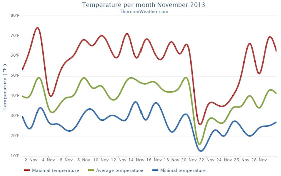
The month of November 2013 goes into the books as a quiet one without much notable in terms of the weather in the Denver area. We enjoyed unusually warm and dry conditions but neither were record-setting.
The month started with average temperatures followed by a couple of days of above normal readings. Colder temperatures and light snow followed on the 4th of the month and lasted until the 6th.
A week of warmer than normal conditions then settled in and lasted through the 20th. On the 21st, a period of five days with colder than normal temperatures arrived as did some light snow on two days during the span.
Temperatures then warmed up from there and above normal temperatures and dry conditions continued through November 30th.
Overall temperatures for the month averaged 39.6 degrees in Thornton. Officially, Denver’s average temperature was 40.9 degrees. Both were a good bit above the historical November average temperature of 43.5 degrees.
Temperatures in Thornton ranged from a high of 71.8 degrees on the 3rd down to a low of 13.7 degrees on the 21st. Denver’s maximum and minimum were 71 degrees on the 13th and 12 degrees on the 21st.
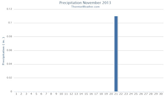
In terms of precipitation, Thornton recorded a scant 0.11 inch of liquid. Denver fared better with 0.27 inches. Both however were below the average November monthly precipitation mark of 0.61 inches.
Thornton saw total of only 1.8 inches snow during the month, most of which (1.6 inches) fell on the 21st. Officially the Mile High City recorded 2.0 inches of snow, all on the 21st. The average November snowfall is 8.7 inches so the 2013 – 2014 snow season is off to a poor start.
No temperature, precipitation or snowfall records were set during the month.
Thornton’s November 2013 Temperature Summary.Thornton’s November 2013 Precipitation Summary.
From the National Weather Service:
...THE DENVER CO CLIMATE SUMMARY FOR THE MONTH OF NOVEMBER 2013...

CLIMATE NORMAL PERIOD 1981 TO 2010
CLIMATE RECORD PERIOD 1872 TO 2013

WEATHER         OBSERVED          NORMAL  DEPART  LAST YEAR`S
                 VALUE   DATE(S)  VALUE   FROM    VALUE  DATE(S)
                                          NORMAL
................................................................
TEMPERATURE (F)
RECORD
 HIGH              80   11/08/2006
 LOW              -18   11/29/1877
HIGHEST            71   11/13        79      -8       77  11/07
LOWEST             12   11/21       -18      30       13  11/11
AVG. MAXIMUM     55.1              52.1     3.0     58.4
AVG. MINIMUM     26.7              24.5     2.2     28.5
MEAN             40.9              38.3     2.6     43.5
DAYS MAX >= 90      0               0.0     0.0        0
DAYS MAX <= 32      2               2.3    -0.3        0
DAYS MIN <= 32     25              23.4     1.6       19
DAYS MIN <= 0       0               0.6    -0.6        0

PRECIPITATION (INCHES)
RECORD
 MAXIMUM         3.21   1946
 MINIMUM            T   1899
                        1901
                        1949
TOTALS           0.27              0.61   -0.34     0.27
DAILY AVG.       0.01              0.02   -0.01     0.01
DAYS >= .01         3               4.7    -1.7        1
DAYS >= .10         1               1.6    -0.6        1
DAYS >= .50         0               0.0     0.0        0
DAYS >= 1.00        0               0.0     0.0        0
GREATEST
 24 HR. TOTAL    0.23   11/21 TO 11/21           11/10 TO 11/10
                        11/20 TO 11/21                    11/09 TO 11/10
                        11/21 TO 11/21                    11/10 TO 11/10
 STORM TOTAL       MM                                 MM
 (MM/DD(HH))            MM                    11/10(00) TO 11/10(00)
                                                 11/10(00) TO 11/10(00)0
                                                 11/10(00) TO 11/10(00)0

SNOWFALL (INCHES)
RECORDS
 TOTAL             MM   MM
TOTALS            2.0               8.7

DEGREE_DAYS
HEATING TOTAL     715               801     -86      638
 SINCE 7/1       1323              1382     -59     1195
COOLING TOTAL       0                 0       0        0
 SINCE 1/1        999               769     230     1236

FREEZE DATES
RECORD
 EARLIEST     09/08/1962
 LATEST       06/08/2007
EARLIEST                        10/07
LATEST                          05/05
.................................................

WIND (MPH)
AVERAGE WIND SPEED              9.0
RESULTANT WIND SPEED/DIRECTION   3/203
HIGHEST WIND SPEED/DIRECTION    31/040    DATE  11/20
HIGHEST GUST SPEED/DIRECTION    45/150    DATE  11/02

SKY COVER
POSSIBLE SUNSHINE (PERCENT)   MM
AVERAGE SKY COVER           0.50
NUMBER OF DAYS FAIR            8
NUMBER OF DAYS PC             18
NUMBER OF DAYS CLOUDY          4

AVERAGE RH (PERCENT)     50

WEATHER CONDITIONS. NUMBER OF DAYS WITH
THUNDERSTORM              0     MIXED PRECIP               0
HEAVY RAIN                0     RAIN                       0
LIGHT RAIN                1     FREEZING RAIN              0
LT FREEZING RAIN          1     HAIL                       0
HEAVY SNOW                1     SNOW                       1
LIGHT SNOW                7     SLEET                      0
FOG                       8     FOG W/VIS <= 1/4 MILE      1
HAZE                      4

-  INDICATES NEGATIVE NUMBERS.
R  INDICATES RECORD WAS SET OR TIED.
MM INDICATES DATA IS MISSING.
T  INDICATES TRACE AMOUNT.
Weather, natural disasters & climate news and information.
 Colorado’s famously inconsistent weather appears to be on full display this month. Just two weeks ago we were setting records for cold. Today we broke a record high temperature and tied the record high minimum.
, At the Mea Shearim Ultra orthodox jewish neighborhood on December 13, 2013 in Jerusalem, Israel.")


 Clear skies and snow cover helped push the mercury down early this morning. The result was a second record low temperature set in the past 24 hours.