ThorntonWeather.com Website News & Change Log

Web Site Change LogOur website is constantly changing as new features are added and old ones are updated. Check here to learn what new features have been added lately.  If you have a suggestion for a new feature or changes you would like to see, please contact us and let us know!

12/24/13

Not directly weather-related but added live video feeds provided by NASA.  Both are available from the Almanac > Astronomy & Space menu on the left.

  • NASA TV live feed – This is NASA’s television channel providing coverage of what the space agency is doing.
  • ISS live feed – Live video from the International Space Station.  Live video of specific tasks being performed by the astronauts is shown or oftentimes live video from the station’s exterior cameras.

9/14/13

  • The map on our Northeastern Colorado River Heights and Flood Status page was not working due to changes in the feed from the Advanced Hydrologic Prediction Service.  The page has now been updated and incorporates an interactive map.  It also displays river heights and flood status for locations across northeastern Colorado.  You can find the page in the Almanac menu at the left.

9/11/13

  • We noticed our Record Weather Event page that is fed from data from the National Weather Service was not working properly.  This was due to some changes by the NWS.  We have fixed this now and you can always check to see what recent record-breaking weather we have experienced by selecting the Denver / Boulder office from the drop down on the page.  The page itself is under the Almanac / National Weather Service menu on the left.

9/1/13

  • Some much-needed behind the scenes work.  The computer that powers all of our weather equipment – the station software, radar, lightning detector, website, etc – was on its last leg.  It served us well for 5 years and it was time to go.  This weekend we replaced the computer with a brand new one with far more computing power.  The upgrade will allow us to continue to bring you the best local weather information and news in Thornton.

8/12/13

  • Due to changes in the way the U.S. Geological Survey formats its data, we updated our earthquake pages.  The new pages now use a Google map to display recent temblors.  We also have two earthquake pages now: One for quakes within a 500 mile radius of Denver, and one for all earthquakes globally.  You can find the pages in the Almanac menu on the left.

7/14/13

  • Changes to our Live Weather Gauges page. Gauges are a bit bigger and easier to read, we added a wind rose, the scrolling text display now shows the forecast and at the bottom you can select different units of measure.

6/27/13

  • We changed our west facing webcam orientation pointing it a bit more vertical.  This will allow a better view of the skies above while still maintaining perspective of nearby trees.

9/2/12

  • We’ve updated our monthly tables for Denver’s “Normals, Means & Extremes” and “”Top 10″ Precipitation & Temp”.  You can find them under the Almanac menu on the left then go to Climatology & Records.  You can also click here.
  • Some time ago we added a WeatherNation TV page that allows you to view broadcasts from the network live on our site.  Now we have added a National & International Video News page with the latest from NDN’s providers including CBS, AP and many more.  It is available under Area Information to the left and then select Video News.

7/3/12

  • The National Weather Service changed their forecast pages and that necessitated changes of our page as well.  While the basics are the same, we took the opportunity to do a bit of an upgrade.  The page will automatically display the forecast for Thornton as always but now there is a dropdown menu that allows you to easily grab the forecast from more than a dozen other cities across Colorado.  Click here to check it out or select ‘NWS 5 day forecast’ from the Forecasts menu on the left.

6/13/12

  • We already have a number of ways to view current weather conditions locally and from across the globe – see the Live Conditions menu at the left.  One new page we added expands on that and provides conditions from Denver area METAR stations.  METARs are permanent weather stations, oftentimes located at airports, that report current conditions in a standardized format (click here for details).  Our METAR page reads data from locations like Denver International Airport, Rocky Mountain Metropolitan Airport, Buckley Air Force Base and a number of other locations and provides their reported weather conditions in an easy to view format.  You can access it from the Live Conditions menu on the left or by clicking here.

6/12/12

  • Our Lightning Detection Center pages are among our most popular during severe weather season.  We have just added a new page that uses StormVue NGX to display lightning activity.  Using Flash, the display gives you the ability to zoom in and out, set alarms, choose what type of strikes to display and much more.  You can check it out here or find it in the Lightning menu to the left.

6/10/12

For anyone that reads our news section or views or Facebook page, you are well aware of our fondness for satellite imagery.  The ‘eyes in the sky’ can provide an amazing view of weather and disasters.  We have added two new pages that allow you to view some of the most amazing imagery:

Continue reading ThorntonWeather.com Website News & Change Log

Santa Claus begins his journey – Track him live

ThorntonWeather.com and NORAD offer the Santa TrackerSanta Claus begins his whirlwind trip around the globe tonight to deliver toys to all the good little boys and girls! For more than 50 years the North American Aerospace Defense Command (NORAD) has tracked Kris Kringle on Christmas Eve and helped to ensure he completes his journey safely.

ThorntonWeather.com is pleased to be able to provide live Santa tracking from NORAD right here on our site!

Click here to check it out and be sure to come back often to see where Kris Kringle is at!

Here’s the first video released today of Santa’s departure from the North Pole:

White Christmases not as common in Denver as one might think

For many, the holiday season isn’t complete without a chill in the air and snow on the ground. Here in Denver we historically enjoy a better chance of experiencing the proverbial white Christmas than many places in the nation.

However, how the Mile High City fares in experiencing a white Christmas does depend on your definition of one.

If it means having actual snowfall on Christmas Day the chances aren’t that good. But, if simply having snow on the ground suffices, the chances improve considerably.

For a complete look at Denver’s Christmas weather statistics, click here.

For the latest Thornton weather forecast for Christmas, check out our forecast page.

Historical probability of a white Christmas (at least 1" of snow on the ground).  NOAA / NCDC
Historical probability of a white Christmas (at least 1″ of snow on the ground). NOAA / NCDC

NASA releases video recreating iconic Apollo 8 Earthrise image

Planet Earth is seen by humans in lunar orbit for the first time during Apollo 8.
Earth is seen by humans in lunar orbit for the first time during Apollo 8. (NASA)

It was Christmas Eve in 1968 when three brave astronauts, the first humans to leave Earth orbit, circled the moon. As the 45th anniversary of that event approaches, NASA has released a video that recreates the iconic Earthrise image that has captivated the world since.

Using imagery obtained from its Lunar Reconnaissance Orbiter, the video released by NASA yesterday allows viewers to see Earthrise as it was first witnessed 45 years ago.

Audio from the Apollo 8 mission provides commentary from the astronauts as they conducted routine observations – until the spacecraft oriented itself to allow them view the planet. The astronauts then scramble to get cameras in place to capture the event.

Read the rest of this story and check out the amazing video on Examiner.com

Denver sets record high and record high minimum temperature for December 18

Record setting high temperatures in Thornton.
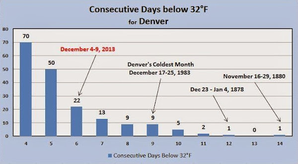
Colorado’s famously inconsistent weather appears to be on full display this month.  Just two weeks ago we were setting records for cold.  Today we broke a record high temperature and tied the record high minimum.

At 12:59 p.m. the temperature at Denver International Airport reached 68 degrees.  This broke the old record high temperature for December 18 of 66 degrees last set in 1979.

Additionally, Denver’s low temperature was 40 degrees.  This tied the record low maximum for the date set in 1917.

The average high for December 18 is 42 degrees and the average low is 17 degrees.

Here in Thornton we were just slightly cooler as the mercury here topped out at 67 degrees at 12:44 p.m.  Our low dropped to 39 degrees.

It was on December 4th and 5th that the Mile High City was in the midst of an Arctic blast that brought six days straight of sub-freezing temperatures.  On those two days Denver set record low temperatures.

Be sure to ‘like’ us on Facebook, follow us on Twitter and add us to your Google+ circles.

Cairo receives first snow in over 100 years, Jerusalem receives most in 50 years

An Ultra Orthodox Jewish man walks in the snow a head of Shabat (Saturday), At the Mea Shearim Ultra orthodox jewish neighborhood on December 13, 2013 in Jerusalem, Israel.
An Ultra Orthodox Jewish man walks in the snow in Jerusalem, Israel. Click to view a slideshow of the event. (Getty Images)

A powerful winter storm system struck parts of the Middle East on Friday to the delight of some residents but causing havoc in other locations where snow is a rarity.

In Cairo, Egypt snow fell, reportedly for the first time in 112 years, covering parts of the city in a light blanket of white.

Parts of Israel saw heavy snow totaling up to three feet. Jerusalem Mayor Nir Barkat told The Times of Israel, “We’re facing a rare storm the likes of which we’ve never seen.”

The local meteorological agency said it was the worst snowstorm seen since at least 1953.

Read the rest of this story with video and photos on Examiner.com

Camera footage shows destruction from deadly Illinois tornado as it happened

Screenshot of a video showing four angles just as a tornado strikes Washington, Illinois on November 17, 2013.
Screenshot of a video showing four angles just as a tornado strikes Washington, Illinois on November 17, 2013. (YouTube)

Last month a tornado outbreak visited death and destruction across multiple states in the nation’s midsection. Security camera footage just release by a homeowner in Illinois whose house was destroyed captures the destruction as it happens.

Over 100 tornadoes spanning seven states were reported on November 17. While the actual number of twisters was likely lower due to duplicates, it was an extraordinary tornado outbreak, particularly given how late in the year it occurred.

The tornado that struck Washington, IL on that fateful day has been determined to be an EF-4 on the Enhanced Fujita Scale.

This week a YouTube user by the name of ‘athlon770’ released security camera footage of the event.

From four different cameras , the video shows exterior views as the tornado approaches and the wind starts throwing debris. In the climax, the inside of the home virtually explodes as it takes a direct strike from the twister.

Following the video, the user adds still photos of the aftermath. It is truly a devastating scene.

Read the rest of this story and check out the video on Examiner.com

Disturbing Greenpeace Santa issues appeal to save his home from climate change

In a video from Greenpeace, global warming has taken its toll on Santa Claus and the North Pole.

Global warming has prompted Santa Claus to issue an urgent appeal to children to help save his home in the Arctic. In a new video from the radical environmental group Greenpeace, the jolly old elf hardly looks like himself as he announces, “I bring bad tidings.”

With labored breaths, Santa says, “For some time now melting ice, here, at the North Pole has made our operations and our day to day life intolerable and impossible and there may be no alternative but to cancel Christmas.”

The timing of Greenpeace’s video is arguably not the best.

The Arctic sea ice minimum, reached in September, saw a 49% increase over the previous year. That represents an increase of 653,000 square miles giving Santa and the reindeer quite a bit more snow and ice to play on and use to prepare for Christmas.

Read the complete story and watch the video on Examiner.com

Thornton’s sub-freezing cold streak notable but not particularly unusual

Thornton, Colorado temperatures during the December 2013 cold spell.

Thornton’s December 2013 Arctic blast has come to an end as the mercury finally climbed above freezing today.  For nearly seven straight days we saw temperatures below 32 degrees.

Soon after noon on Tuesday, December 3 the cold front arrived along the Colorado Front Range.  The mercury would plummet quickly from a high that day of 55.9 degrees and drop below freezing at 1:56 p.m.

It wasn’t until 9:12 a.m. this morning when the temperature finally climbed above 32 degrees, the rising temperatures being pushed higher by Chinook winds.  In all, sub-freezing temperatures were recorded for 6 days, 19 hours and 16 minutes straight.

Looking at how the event ranks in comparison to historical Denver cold spells, it falls short of making the list of top 10 longest periods with maximum temperatures below freezing.

Number 10 on the list is a nine day streak that ended on December 25, 1983.  The top spot goes to a 14 day period that ended on November 29, 1880.

During the recent cold spell Denver recorded two low temperature records.

Snowfall was relatively minimal however as is often the case when temperatures drop so far.  Thornton measured 2.4 inches and Denver 3.1 inches.

The table below shows the high and low temperatures for Thornton and Denver during the cold spell.

Date Thornton High Thornton Low Denver High Denver Low
12/3/13 55.9 11.4 56 11
12/4/13 12.3 -4.3 11 -13 *
12/5/13 12.2 -9.3 8 -15 *
12/6/13 12.3 -6.8 8 -13
12/7/13 13.9 -6.6 9 -11
12/8/13 20.9 1.8 17 -5
12/9/13 30.5 -3.8 25 -4
12/10/13 46.9 13.2

* Record low temperatures

Denver, Colorado sub-freezing temperature streaks.  (National Weather Service)
Denver, Colorado sub-freezing temperature streaks. (National Weather Service)


The minimum temperature at Denver International Airport dropped below zero for six consecutive days from December 4th through December 9th 2013. The longest consecutive stretch of below zero low temperatures occurred back in December of 1972. (National Weather Service)
The minimum temperature at Denver International Airport dropped below zero for six consecutive days from December 4th through December 9th 2013. The longest consecutive stretch of below zero low temperatures occurred back in December of 1972. Click for a larger view. (National Weather Service)

Jimmy Kimmel makes fun of Los Angeles TV stations’ attempts to hype LA cold

Much of the nation’s mid-section was plunged into a deep freeze this past week with temperatures registering below zero in many locations. On the west coast where the weather is rarely dramatic, Los Angeles TV stations played up their version of ‘cold’ and late-night TV host Jimmy Kimmel made fun of them.

“Southern California is getting a bitter blast of cold weather this morning,” one news anchor proclaimed.

More hardy residents in other parts of the nation undoubtedly laughed at the attire of In-the-field reporters. While trying to hype the cold, reporters wore heavy coats, scarves and gloves to battle those cold 50 degree temperatures.

Read the rest of this story and check out video of Kimmel’s monologue on Examiner.com
Late night TV host Jimmy Kimmel found attempts to hype "cold" temperatures in Los Angeles comical.

Weather, natural disasters & climate news and information.