|
|
March preview: Biggest snow month also brings much milder temperatures
The past two months have brought periods of extreme cold but not a lot of snow to Denver. March however is our snowiest month and may bring a turnaround in those numbers. It also typically brings much warmer temperatures.
March is historically Denver’s snowiest month and brings about 20% of our annual snowfall. Heavy, wet spring snow storms can oftentimes bring the entire month’s snowfall total in one monstrous snow.
We also start the transition to spring and severe weather season and the month typically brings our first thunderstorms of the year. Temperatures climb throughout the month and by the end our average daytime highs are near 60 degrees.
For a complete look at what lies ahead in March 2014, click here.

February 2014 top shots: Monthly photo slideshow
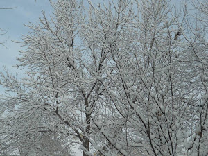
The month of February is one that begins a transition to warmer temperatures and oftentimes lacks snowfall. Nevertheless, Mother Nature oftentimes offers stunning scenes to be captured in imagery as we see in our February 2014 slideshow.
- Slideshow updated February 28, 2014
Showcasing images captured by ThorntonWeather.com readers as well as some of our own, our monthly slideshow covers the entire gamut of weather-related imagery. Sunsets, sunrises, wildlife and of course snow are vividly depicted.
Throughout the month we will gather the images sent to us via email or shared with us via our various social media outlets and post them in the slideshow below.
To learn more about getting your photos added to our monthly slideshow, click here.
Click the play button below and sit back and enjoy the images.
Health links hyped to drive fear of fracking despite studies that fail to back up claims
|
|
Farmers’ Almanac Proves Itself More Accurate Than Climate Scientists
|
|

Volcanic eruptions help slow global warming
|
|
Video: NASA animation shows polar vortex and its far reaching effects

Unseasonably cold weather gripped much of the nation in January and brought a term to public’s consciousness they may not have heard before: polar vortex. As explained in a video from NASA, the ‘stretching’ of the vortex was responsible for the record-setting cold seen last month.
NASA writes:
This movie of temperature observations from NASA’s Atmospheric Infrared Sounder (AIRS) instrument on NASA’s Aqua spacecraft depicts the first major North American weather event of 2014: cold air moving out of the Arctic and south to cover much of the continent. The temperatures shown are at a pressure of 850 hectopascals (hPa, formerly knows as millibars; sea level pressure is normally around 1000 hPa). Pressures of 850 hPa correspond to an altitude of about 3,000 feet (1 kilometer) above sea level. The temperatures in the movie range from about minus 18 degrees Fahrenheit (245 Kelvin or minus 28 degrees Celsius) to warmer than 66 degrees Fahrenheit (290 Kelvin or about 17 degrees Celsius). The very coldest temperatures in purples and blues are minus 18 to 17 degrees Fahrenheit (minus 28 to about minus 8 degrees Celsius).
The most obvious feature of the movie is the tongue of cold air moving out of Canada and southward to cover much of the eastern United States during early January 2014. This event was covered extensively in the media, and introduced the term ‘polar vortex’ to a broader audience.
This global perspective illustrates some features not noted in all the recent media attention. Perhaps most obvious: this is not a global phenomenon. The eastern half of the United States includes only about one percent of the total surface area of the planet (about two million of 197 million square miles). One advantage of satellite observations, as from AIRS, is coverage of the entire planet. A truly global perspective is required when studying variations in climate, and this event must be compared against a number of other phenomena occurring around the planet. Note that Alaska and northern Eurasia were warm during this period of unusual cold over the eastern United States.
Photo: Bald eagle and afternoon iridescent clouds
One of our friends was hanging out along the South Platte again this afternoon. Had to shoot pictures into the sun but with the iridescent clouds in the background it looks really cool.
Cloud iridescence is caused by clouds (usually cirrus) that have small water droplets or ice crystals in them causing the light to be diffracted, or spread out. The phenomena is much like the rainbow colors seen with oil in water.
Remember we are always looking for pics of just about anything to add to our monthly slideshow. Be sure to email or post them so we can add them. Check out this month’s slideshow here.

Denver sets record coldest high temperature for February 6
 The big chill continued on Thursday as for the second day in a row the Mile High City’s high temperature set a record as the coldest for the date.
As officially measured at DIA, Denver’s high temperature today was 1 degree. That easily bested the previous record low maximum for February 6 of 5 degrees set in 1929 and years prior.
The mark was an improvement, albeit a slight one, over yesterday’s high of 1 degree below zero which also set a record.
Here in Thornton we fared slightly better with our high temperature topping out at 4 degrees today and 1.9 degrees on Wednesday.
Warmer weather is on the way as the cold Arctic air mass is expected to be pushed out tomorrow. Temperatures on Friday should climb above freezing for the first time in eight days.
Arctic chill breaks cold temperature record in Denver
 With a large, cold air mass settled in across much of the nation’s midsection, weather records are bound to fall. In the Mile High City the record for coldest high temperature for the date was not just broken but smashed.
The so-called high temperature for the day was 1 degree below zero in Denver. This shattered the previous coldest high temperature for February 5 of 5 degrees set in 1989 and years prior.
- Article adapted from the Denver Weather Examiner with permission
Overnight temperatures Tuesday night into Wednesday morning dropped to a bone-chilling 19 degrees below zero as measured at Denver’s official weather station at Denver International Airport. Daytime provided little relief as the mercury remained stubbornly below zero.
Here in Thornton we fared slightly better with a daytime high temperature of 2 degrees above zero. Our low temperature this morning was a nasty cold 12.6 degrees below.
- How cold is it? Live weather gauges
- Winter Weather Preparedness: Hazards of wind chill, hypothermia and frostbite
With temperatures Wednesday night expected to plunge to 10 below or lower, a Wind Chill Advisory has been issued for much of northeastern Colorado including Denver. Wind chill temperatures of 25 below will be possible.
This type of cold comes with it the very real danger of hypothermia and frostbite. Area residents need to exercise extreme caution and avoid prolonged exposure. Pets as well need to be remembered and their time outside should be limited.