The past week or so has brought quite a variety of weather, most notably seven straight days of precipitation. On Saturday we saw a continuation of the rain which changed to snow overnight, an event captured by one of our webcams.
Over the seven days, Thornton recorded a whopping 4.34 inches of liquid precipitation. Most of that fell as rain but 5.1 inches of snow provided some of that as well.
The video below shows the period from 3:00pm on Saturday, May 9 through 5:00pm on Sunday, May 10 compressed to about 53 seconds. It starts with rain which soon transitions to snow as the evening arrives. The snow continues into the following morning and then skies begin to clear and the snow quickly melts.
To go along with our Mother’s Day snow, we also have seen some cold – record-setting cold in fact.
Denver’s official low temperature, as measured at Denver International Airport, dropped to 27 degrees this morning. That ties the record low for today’s date set previously in 1946.
Here in Thornton we were just a little bit warmer with a low of 28 degrees this morning.
In terms of snowfall, Denver reported 4.0 inches at DIA as of 7:00am this morning. Here in Thornton we received 5.1 inches.
Looking ahead, the record low for May 11 is 28 degrees (also in 1946). With clearing skies later today and into tonight, it wouldn’t be surprising to see that mark tied or broken tomorrow AM.
Stay up to date with Thornton’s weather: Be sure to ‘like’ us on Facebook, follow us on Twitter and add us to your Google+ circles.
Colorado’s famously highly variable weather seems to showcase itself during the month of May when a variety of weather conditions can be seen.
Winter-like temperatures and snow are possible as are mid-summer like temperatures or the more typical spring severe weather.
As the month starts out in 2015 we are going to enjoy a mild period with unseasonably warm temperatures but with unsettled conditions. Long range forecasts lean toward overall warmer than normal temperatures and above normal precipitation.
However the month can bring extremes. Snow is not entirely uncommon during the month, oftentimes causing damage to newly bloomed trees. More common however is severe weather, particularly in the latter half of the month. Thunderstorms become more frequent and their associated hazards – lightning, wind, hail and tornadoes – are usual visitors.
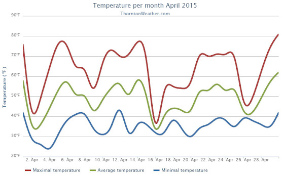
We began the month of April in the need of moisture and while we didn’t do much to bolster our snowfall numbers, rain proved to be a big help. Temperatures were relatively stable but did end up a bit above average.
The first half of the month offered mostly dry conditions and warmer than normal temperatures. The only real exception was a light snowfall on the 2nd and 3rd of the month. Otherwise we saw virtually no precipitation for the first 15 days of April.
The latter half however saw a shift in the weather pattern courtesy of a number of storm systems that moved through. These led to cooler temperatures and some nice shots of precipitation.
A system on the 15th and 16th brought only 3.9 inches of snowfall but a healthy 1.68 inches of liquid precipitation from snowmelt and rain. We then remained mostly dry up until the 26th when another good shot of rain arrived.
Thornton’s average temperature for April 2015 was 49.0 degrees, a good bit above the long term April average of 47.4 degrees. Out at the airport, Denver saw similar readings to ours with an average of 48.7 degrees.
Temperatures in Thornton ranged from a low of 24.0 degrees on the morning of the 4th up to a high of 80.7 degrees on the 30th. Denver’s coldest reading was 27 degrees on the 3rd and its warmest came on the 30th with a temperature of 79 degrees.
In terms of precipitation, Thornton saw 2.68 inches of precipitation for the month. Officially, as measured at DIA, Denver took a very similar 2.65 inches into their bucket. Both readings were a good ways above the April average of 1.71 inches.
Snowfall failed to be anything extraordinary. Both Thornton and Denver saw 5.3 inches of the white stuff, a good bit below the average of 6.8 inches.
Thornton, Colorado temperatur?e summary for April 2015. (ThorntonW?eather.com?)Thornton, Colorado precipitat?ion summary for April 2015. (ThorntonW?eather.com?)
From the National Weather Service:
CLIMATE REPORT
NATIONAL WEATHER SERVICE BOULDER, CO
552 AM MDT FRI MAY 1 2015

...................................

...THE DENVER CO CLIMATE SUMMARY FOR THE MONTH OF APRIL 2015...

CLIMATE NORMAL PERIOD 1981 TO 2010
CLIMATE RECORD PERIOD 1872 TO 2015

WEATHER         OBSERVED          NORMAL  DEPART  LAST YEAR`S
                 VALUE   DATE(S)  VALUE   FROM    VALUE  DATE(S)
                                          NORMAL
................................................................
TEMPERATURE (F)
RECORD
 HIGH              90   04/30/1992
 LOW               -2   04/02/1975
HIGHEST            79   04/30                         80  04/22
LOWEST             27   04/03                         18  04/14
AVG. MAXIMUM     62.1              61.5     0.6     62.8
AVG. MINIMUM     35.3              33.3     2.0     35.2
MEAN             48.7              47.4     1.3     49.0
DAYS MAX >= 90      0               0.0     0.0        0
DAYS MAX <= 32      0               0.3    -0.3        0
DAYS MIN <= 32      7              13.0    -6.0       10
DAYS MIN <= 0       0               0.0     0.0        0
PRECIPITATION (INCHES)
RECORD
 MAXIMUM         8.24   1900
 MINIMUM         0.03   1963
TOTALS           2.65              1.71    0.94     1.24
DAILY AVG.       0.09              0.06    0.03     0.04
DAYS >= .01         9               9.1    -0.1        6
DAYS >= .10         6               4.5     1.5        5
DAYS >= .50         2               0.9     1.1        0
DAYS >= 1.00        1               0.5     0.5        0
GREATEST
 24 HR. TOTAL    1.41   04/16 TO 04/17           04/02 TO 04/03

SNOWFALL (INCHES)
RECORDS
TOTAL            33.8   1933
TOTALS            5.3               6.8

DEGREE_DAYS
HEATING TOTAL     481               529     -48      472
 SINCE 7/1       5205              5731    -526     5730
COOLING TOTAL       0                 1      -1        0
 SINCE 1/1          0                 1      -1        0

FREEZE DATES
RECORD
 EARLIEST     09/08/1962
 LATEST       06/08/2007
EARLIEST                        10/07
LATEST                          05/05
....................................................

WIND (MPH)
AVERAGE WIND SPEED              10.7
HIGHEST WIND SPEED/DIRECTION    41/350    DATE  04/15
HIGHEST GUST SPEED/DIRECTION    52/280    DATE  04/12

SKY COVER
POSSIBLE SUNSHINE (PERCENT)   MM
AVERAGE SKY COVER           0.60
NUMBER OF DAYS FAIR            7
NUMBER OF DAYS PC             16
NUMBER OF DAYS CLOUDY          7

AVERAGE RH (PERCENT)     58

WEATHER CONDITIONS. NUMBER OF DAYS WITH
THUNDERSTORM              6     MIXED PRECIP               0
HEAVY RAIN                2     RAIN                       7
LIGHT RAIN               11     FREEZING RAIN              0
LT FREEZING RAIN          0     HAIL                       1
HEAVY SNOW                1     SNOW                       3
LIGHT SNOW                4     SLEET                      0
FOG                      10     FOG W/VIS <= 1/4 MILE      5
HAZE                      3

-  INDICATES NEGATIVE NUMBERS.
R  INDICATES RECORD WAS SET OR TIED.
MM INDICATES DATA IS MISSING.
T  INDICATES TRACE AMOUNT.
May 3 to May 9: This week in Denver weather history
A very eventful week in Denver weather history. Four tornadoes are mentioned and many reminders that winter may not be over just quite yet.
From the National Weather Service:
1-5
In 1898…snowfall totaled 15.5 inches in downtown Denver. Most of the snow…6.2 inches… Fell on the 3rd. Most of the snow melted as it fell. The greatest snow depth on the ground was only 2.5 inches on the 3rd at 8:00 pm. This was the only snowfall during the month. Northeast winds were sustained to 22 mph on the 1st.
2-3
In 1979…heavy rain changed to snow on the 2nd. Snowfall totaled 3.9 inches at Stapleton International Airport… Where northwest winds gusted to 26 mph. The greatest depth of snow on the ground was only 1 inch at midday on the 2nd due to melting. Total precipitation for the 2 days was 1.65 inches.
2-4
In 1987…a slow moving storm brought rain…wind… And snow to metro Denver. Rainfall totaled 1.04 inches at Stapleton International Airport where north winds gusted to 48 mph on the 3rd. The foothills received 5 to 10 inches of snow.
2-5
In 2001…a very slow moving pacific storm system became parked near the Four Corners region…which allowed heavy snow to develop above 6500 feet in the foothills with a mix of rain and snow over lower elevations of metro Denver. Snowfall totals included: 21 inches atop Crow Hill and at Idaho Springs; 19 inches near Blackhawk; and 18 inches in Coal Creek Canyon…Genesee… And 11 miles southwest of Morrison. Snowfall totaled 6.2 inches at the site of the former Stapleton International Airport. Precipitation (rain and melted snow) totaled 2.09 inches at Denver International Airport where north winds gusted to 30 mph on the 2nd.
3
In 1898…heavy snowfall of 6.2 inches fell over downtown Denver. Most of the snow melted as it fell. The greatest snow depth on the ground was 2.5 inches during the evening.
In 1907…the all-time lowest recorded temperature in the month of May…19 degrees… Occurred.
In 1925…an apparent microburst produced sustained northeast winds to 44 mph with gusts to 52 mph. Rainfall was only 0.01 inch in downtown Denver.
In 1981…lightning struck 9 golfers at the south suburban golf course. None were injured seriously.
In 1983…hail 1 1/2 inches in diameter fell at Green Mountain west of Lakewood…with 3/4 inch stones reported in Lakewood.
In 1986…a thunderstorm wind gust to 51 mph was recorded at Stapleton International Airport.
3-5
In 1908…rain changed to snow on the evening of the 3rd and continued through the early evening of the 5th. Snowfall totaled 10.0 inches over downtown Denver. This was the last measurable snow of the season. Precipitation totaled 1.51 inches. North winds were sustained to 23 mph on the 3rd…33 mph on the 4th… And 21 mph on the 5th. Three temperature records were set. High temperatures of 30 degrees on the 4th and 38 degrees on the 5th were record low maximum temperatures for the dates. The reading on the 4th was also the all-time record low maximum for the month of May.
In 2007…a slow moving pacific storm system… From the desert southwest…brought a period of unsettled weather to the region. During the 3-day period…locally heavy snow was reported over parts of the Front Range foothills. Storm totals included: 15 inches near Conifer…14.5 inches west of Jamestown…13.5 inches; 6 miles southwest of Evergreen…and 12.5 inches at pine junction. Severe thunderstorms…producing large hail… Up to one inch in diameter were observed in the vicinity of Boulder and Hudson. Lightning struck a residence in Jefferson County. The roof was hit…causing the attic to catch fire. At Denver International Airport…lightning struck a united airlines jet as it was pushing away from the gate. The passengers were taken off the jet and put on another plane.
4
In 1893…northwest winds were sustained to 42 mph.
In 1971…a funnel cloud was sighted 10 miles southwest of Boulder. Hail stones to 1 inch in diameter fell in southeast Denver…but caused only minor damage.
In 2006…a severe thunderstorm produced hail to 1.00 inch in diameter in Aurora near Cheery Creek Reservoir.
In 2010…high winds downed trees and power lines across parts of the Front Range foothills and urban corridor. Downed power lines sparked a 12-acre wildfire near Conifer. In Boulder…Longmont and Louisville… The wind damaged roofs and broke windows and skylights. Peak wind gusts included: 75 mph in northwest Longmont…71 mph at the national wind technology center and 4 miles south- southwest of superior…61 mph at Broomfield and 56 mph in Erie. At Denver International Airport…a peak wind gust to 46 mph was observed.
4-5
In 1986…high winds buffeted the foothills. Wind speeds of 60 to 75 mph were recorded in Boulder. At Stapleton International Airport…west winds gusted to 45 mph on the 4th and to 40 mph on the 5th.
In 2000…a brief warm spell resulted in setting two daily high temperature records. The temperature climbed to highs of 87 degrees on the 4th and 89 degrees on the 5th.
4-8
In 1969…heavy rains caused flooding on Boulder Creek in Boulder…which resulted in one death on the 7th. Flooding also occurred on bear creek in Sheridan and on the South Platte River in Denver. Rain over most of the eastern foothills started late on the 4th and continued with only brief interruptions in many areas until the morning of the 8th. Very high rates of rainfall occurred on the 6th and 7th with the greatest intensities in a band along the foothills from about 25 miles southwest of Denver northward to Estes Park. Storm totals by both official and unofficial measurements exceeded 10 inches over much of this area and were over 12 inches in some localities. Heavy snow fell in the higher mountains and in the foothills later in the period. The saturation of the soil resulted in numerous rock and landslides…and the heavy run-off caused severe damage along many streams and flooding on the South Platte River. Many foothill communities were isolated as highways were blocked and communications disrupted. Roads were severely damaged over a wide area…and a large number of bridges washed out. Many roads were closed due to the danger from falling rocks. A building in Georgetown collapsed from the weight of heavy wet snow. In Boulder…a man drowned when caught by the flooding waters of Boulder Creek…and a patrolman was injured. Rainfall totaled 7.60 inches in Boulder with 9.34 inches recorded at the public service company electric plant in Boulder Canyon. In Morrison…rainfall totaled 11.27 inches in 4 days. Heavy rainfall totaled 4.68 inches at Stapleton International Airport over 3 days from the 5th through the 7th. Rainfall of 3.14 inches was recorded in 24 hours on the 6th and 7th. Downstream flooding continued along the South Platte River until the 12th when the flood crest reached the Nebraska line.
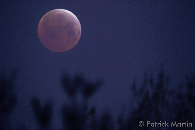
A total lunar eclipse was one of the highlights of April 2015. (Patrick Martin)
April can be a tricky month weather-wise with everything from mild temperatures to snow to severe weather being possible. The good thing about that is that it provides plenty of chances for great photos!
April marks a transition between winter and summer for most of the country but for Denver it is especially true as we can see a stunning variety of weather. The proverbial April showers are certainly a possibility for Denver. Snow? Tornadoes? Thunderstorms? You bet – all can happen!
Throw in our usual wildlife plus the wide variety of birds that return to the Centennial State for the spring and summer and there is a lot going on.
Slideshow updated April 30, 2015. To learn more about how to send your photo to us for inclusion in the slideshow, see below the slideshow.
Showcasing images captured by ThorntonWeather.com readers as well as some of our own, our monthly slideshow covers the entire gamut of weather-related imagery.
Sunsets, sunrises, wildlife and of course every type of weather condition are vividly depicted in images captured from yours and our cameras.
[flickr_set id=”72157649591335084″]
What is missing in the slideshow above? Your photo!
Our monthly photo slideshow is going to feature images that we have taken but more importantly images that you have captured. The photos can be of anything even remotely weather-related.
Landscapes, current conditions, wildlife, pets, kids. Whimsical, newsy, artsy. Taken at the zoo, some other area attraction, a local park, a national park or your backyard. You name it, we want to see and share it!
Images can be taken in Thornton, Denver or anywhere across the extraordinary Centennial State. We’ll even take some from out of state if we can tie it to Colorado somehow.
We’ll keep the criteria very open to interpretation with just about any image eligible to be shown in our slideshows.
What do you win for having your image in our slideshow? We are just a ‘mom and pop’ outfit and make no money from our site so we really don’t have the means to provide prizes. However you will have our undying gratitude and the satisfaction that your images are shared on the most popular website in Thornton.
To share you images with us and get them included in the slideshow just email them to us or share them with ThorntonWeather.com on any of the various social media outlets. Links are provided below.
April 26 to May 2: This week in Denver weather history
This week in Denver weather history shows the extremely wide variety of conditions we can have this year. From major snow storms to hail dropping thunderstorms, we can see it all.
From the National Weather Service:
24-26
In 1924…post-frontal rain changed to snow… Which became heavy and totaled 10.2 inches over downtown Denver. The greatest amount of snow on the ground was 6.0 inches on the 25th due to melting. North winds were sustained to 38 mph with gusts to 42 mph on the 24th.
25-26
In 1985…a spring storm brought much rain and snow to metro Denver. The foothills were buried with 15 inches of snow at Conifer and 12 inches at Evergreen. At lower elevations… An inch or more of rain fell in Denver and Boulder. The heavy precipitation caused brief power outages in the Denver area. Precipitation totaled 1.06 inches at Stapleton International Airport…including only 0.7 inch of snowfall.
25-27
In 1877…snow ended around 7:00 am on the morning of the 27th… After falling continuously for 48 hours and totaling an estimated 13 inches in the city. The storm…likely accompanied by strong winds…caused trains to be delayed for 2 to 3 days. One or two roofs of small buildings were crushed by the weight of the snow…and many tree branches were broken in the city. There were a number of reports of livestock losses. One stockman lost 17 horses and several cattle from the snow and cold. Precipitation totaled 1.30 inches from the storm.
26
In 1965…while only 0.40 inch of rain fell at Stapleton International Airport…some communities in the foothills west of Denver reported over 30 inches of snow from the storm.
In 1972…a spring snow storm accompanied by thunder dumped 15.8 inches of heavy wet snow on metro Denver. Strong northwest winds gusting to 35 mph produced blowing snow. The storm was quite intense and greatly hampered travel. High winds caused drifts 10 to 15 feet deep in some areas… Blocking roads and stranding hundreds of motorists. An estimated 500 to 600 people were stranded in the Castle Rock area. Rescue service was provided by heavy army equipment from Fort Carson. Power lines were downed…power poles were toppled…and a number of steel towers carrying high voltage power lines were downed. Some areas northeast of Denver were without power for a week. A large number of cattle and sheep were killed by the storm. The greatest snow depth on the ground at Stapleton International Airport was 12 inches. Warm temperatures following the storm quickly melted the snow.
In 1995…the third major snow storm of the month dumped heavy snow in and near the Front Range foothills. Six to 12 inches of heavy wet snow fell in the western metro suburbs with the heaviest amounts above 6 thousand feet. Both Boulder and Golden measured 10 inches of snow. Only 2.4 inches of snowfall were measured at the site of the former Stapleton International Airport. North winds gusted 28 mph at Denver International Airport.
In 1998…the last in a series of April storms blanketed the foothills with heavy snow. Snowfall amounts included: 17 inches near Blackhawk…15 inches at Idaho Springs… 14 inches at Georgetown…11 inches near Conifer and Morrison. Only a trace of snow fell at the site of the former Stapleton International Airport. North winds gusted to 28 mph at Denver International Airport.
26-27
In 1906…rain changed to heavy snow overnight and totaled 7.0 inches over downtown Denver. North winds were sustained to 16 mph on both days. Precipitation totaled 2.16 inches.
In 1932…the temperature remained below freezing for more than 30 consecutive hours. For about 4 of those hours the temperature hovered around 24 to 25 degrees. At this time some early cherry trees were in bloom and apple and lilac blossoms were beginning to open. The leaves of many plants were partly unfurled and vegetation in general was correspondingly advanced due to the warm weather from the 11th to the 22nd. However…there was little apparent injury to foliage and blossoms…but some of the early cherry and apple blossoms were injured. Rain changed to snow on the 26th and continued intermittently through the 27th. Snowfall totaled only 2.0 inches and northeast winds gusted to 22 mph on the 26th.
In 1964…strong winds caused damage to buildings…trees… And power lines. Sustained winds of 37 mph with gusts of 50 to 60 mph were recorded in metro Denver. West-northwest winds gusted to 44 mph at Stapleton International Airport on the 26th.
27
In 1955…west winds at 43 mph with gusts as high as 55 mph were recorded at Stapleton Airport where blowing dust briefly reduced the visibility to 3/8 mile.
In 1966…a northwest wind gust to 51 mph was recorded at Stapleton International Airport.
27-28
In 1919…rainfall totaled 2.03 inches for the two days… Along with a trace of snowfall. Northwest winds were sustained to 24 mph with gusts to 26 mph on the 27th.
In 1975…high winds gusting to 85 mph severely damaged a mobile home in Boulder and caused other minor damage. West winds gusted to 46 mph at Stapleton International Airport on the 28th.
In 1996…heavy snow fell over portions of the Front Range foothills west of Denver. Snowfall amounts ranged from 4 to 7 inches. Only 0.3 inch of snow fell at the site of the former Stapleton International Airport. North winds gusted to 41 mph at Denver International Airport on the 27th.
28
In 1894…southwest winds were sustained to 35 mph with gusts as high as 60 mph.
In 1896…apparent post-frontal bora winds from the northwest were sustained to 43 mph with gusts as high as 56 mph. Rainfall totaled 0.22 inch.
In 1990…high winds raked the northeastern plains and eastern foothills from Boulder north. Wind gusts to 70 mph were recorded in Boulder. West winds gusted to 41 mph at Stapleton International Airport.
In 2001…a 21-year-old man was struck by lightning along the shoulder of I-225 near Parker road. His brother`s car had broken down and he stopped to help. The bolt briefly stopped the man`s heart and caused the right side of his body to go numb.
In 2003…severe thunderstorms produced large hail across southern metro Denver. Hail to 1 3/4 inches in diameter fell in Englewood and 2 miles east of Centennial Airport. Hail as large as 1 1/2 inches in diameter fell in Aurora near Cherry Creek. Other large hail reports included 1 inch hail near Bennett…and 7/8 inch hail in greenwood village and at Centennial Airport.
28-29
In 1950…snowfall totaled 6.3 inches at Stapleton Airport…but only 3.5 inches over downtown Denver.
In 1960…heavy snow fell at Stapleton Airport where 8.6 inches of snow were measured. North winds gusted to 38 mph. Most of the snow…6.9 inches… Fell on the 29th.
29
In 1898…apparent thunderstorm winds were sustained from the southwest to 58 mph with gusts to 66 mph.
In 1909…north winds were sustained to 44 mph behind an apparent cold front. These were the strongest measured winds of the month that year.
In 1962…heavy snowfall totaled 6.4 inches at Stapleton Airport where northeast winds gusted to only 17 mph. Snow fell all day…but the most on the ground was only 1 inch due to melting.
In 1991…two men were struck by lightning while golfing in cherry hills just south of Denver. The two received only minor burns. Shortly afterward…lightning struck a home in Cherry Hills Village several times…leaving numerous holes in the roof. No injuries were reported.
In 1993…localized strong winds occurred at Jefferson County Airport near Broomfield where gusts to 63 mph were recorded. The strong winds were the result of a probable microburst.
In 2000…several severe thunderstorms producing large hail and destructive winds rumbled across northern metro Denver. Thunderstorm wind gusts reached 81 mph near Hudson with hail as large as 3/4 inch in diameter at Longmont. Several homes and vehicles sustained damage. The strong winds uprooted trees and downed utility poles…causing scattered outages. Lightning sparked a house fire in Boulder. The fire damaged a portion of the roof and a bedroom on the third floor. Thunderstorm winds gusted to 53 mph at Denver International Airport.
In 2003…lightning struck a chimney at a residence in Hiwan in Evergreen…sending stones flying as far as 150 feet. Electrical equipment in some nearby homes also failed. Damage to the residence…in addition to electrical equipment…was estimated at 100 thousand dollars. Severe thunderstorms produced large hail to 1 inch in diameter near Hudson and Sedalia and to 3/4 inch near Parker. Hail as large as 1 3/4 inches was measured 9 miles north of Sedalia.
In 2014…high winds occurred east of interstate 25. Peak wind gusts included: 71 mph just north of Strasburg; 68 mph at Denver International Airport; 62 mph near Elizabeth; 58 mph at Front Range airport in Watkins and 11 miles east of Parker.
Clouds of snow and ice roar down Mount Everest. Watch the stunning video below. (YouTube / Jost Kobusch)
As the death toll from Saturday’s massive magnitude 7.8 earthquake in Nepal continues to climb, a stunning video has emerged showing an avalanche striking the Mount Everest base camp.
The video, taken by German climber Jost Kobusch, was discovered on YouTube yesterday.
In it, climbers preparing for their ascent of the world’s highest peak first get a sense something is amiss when the ground starts rumbling. Soon, a massive wall of snow is seen coming down the mountain and engulfing the videographer.
While Kobusch survived, at least 18 other climbers on the mountain died. Overall the death toll from the earthquake has reached nearly 3,800, most of whom perished in Nepal.
On the mountain, the Khumbu Icefall, the primary way up the mountain, has been blocked. Hundreds of climbers and their Sherpa’s were trapped at the higher camps and are now being evacuated by helicopter.
Watch the stunning video below. Adult language warning.
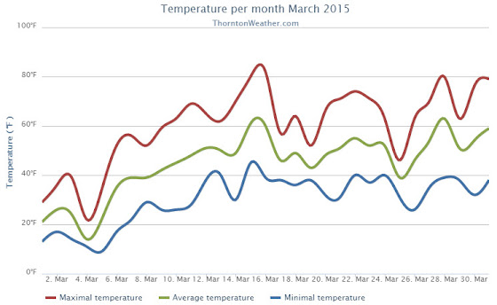
The month of March was relatively uneventful and lacked any sort of real weather drama. What was notable was the dry conditions and unseasonably warm temperatures that dominated for the most part.
March started out considerably colder than normal with the first five days of the month seeing temperatures around 20 degrees below normal. A light shot of snow was recorded on the fourth of the month, a reading that would be our biggest snowfall for the period.
Temperatures began to turn warmer on the sixth with above normal readings recorded through the 16th of the month. We even managed two 80+ degree days on the 15th and 16th.
Denver actually saw its earliest 80 degree reading in history on the 16th. The previous earliest 80 degree reading occurred on March 18, 1907.
Unsettled conditions interrupted the warmth on the 25th with a light snowfall and colder temperatures.
We then bounced right back to the dry, mild conditions for the balance of the month.
Thornton’s average temperature for the month came in at 44.9 degrees. This was well above the long term Denver average of 40.4 degrees. Out at DIA, the Mile High City’s reading was very similar at 45.0 degrees.
Temperatures in Thornton ranged from a high of 82.6 degrees on the 16th down to a low of 9.2 degrees on the 5th of the month. At the airport, Denver’s maximum for the month of 81 degrees came on the 16th with its lowest of 2 degrees on the 5th.
Denver officially broke two temperature records in March 2015. On March 6th the high temperature of 79 degrees broke the record high for the date (previously 76 degrees set in 2013). Also, on the 16th, the high temperature reading of 81 degrees was a record (previously 75 degrees in 2012).
In terms of precipitation, the rain bucket totals fell well short of the March average of 0.92 inch. Here in Thornton a mere 0.49 inches was recorded while Denver saw quite a bit more with a measurement of 0.79 inches.
March is historically our snowiest month but that was certainly not the case in 2015. Thornton snowfall totally only 2.8 inches and Denver was at 2.9 inches. Both were well below the average of 10.7 inches.
Thornton, Colorado March 2015 Temperature Summary. (ThorntonWeather.com)Thornton, Colorado March 2015 Precipitation Summary. (ThorntonWeather.com)
CLIMATE REPORT
NATIONAL WEATHER SERVICE BOULDER, CO
633 AM MDT WED APR 1 2015

...................................

...THE DENVER CO CLIMATE SUMMARY FOR THE MONTH OF MARCH 2015...

CLIMATE NORMAL PERIOD 1981 TO 2010
CLIMATE RECORD PERIOD 1872 TO 2015

WEATHER         OBSERVED          NORMAL  DEPART   LAST YEAR`S
                 VALUE   DATE(S)  VALUE   FROM    VALUE  DATE(S)
                                          NORMAL
................................................................
TEMPERATURE (F)
RECORD
 HIGH              84   03/26/1971
 LOW              -11   03/28/1886
HIGHEST            81   03/16/2015                    73  03/09
LOWEST              2   03/05/2015                     4  03/02
AVG. MAXIMUM     58.9              54.4     4.5     55.8
AVG. MINIMUM     31.2              26.4     4.8     25.9
MEAN             45.0              40.4     4.6     40.9
DAYS MAX >= 90      0               0.0     0.0        0
DAYS MAX <= 32      2               1.9     0.1        2
DAYS MIN <= 32     12              23.6   -11.6       23
DAYS MIN <= 0       0               0.1    -0.1        0
PRECIPITATION (INCHES)
 RECORD
  MAXIMUM         4.56   1983
  MINIMUM         0.03   2012
TOTALS           0.79              0.92   -0.13     0.83
DAILY AVG.       0.03              0.03    0.00     0.03
DAYS >= .01         5               5.9    -0.9        9
DAYS >= .10         3               2.4     0.6        2
DAYS >= .50         0               0.3    -0.3        0
DAYS >= 1.00        0               0.1    -0.1        0
GREATEST
 24 HR. TOTAL    0.34   03/19 TO 03/19

SNOWFALL (INCHES)
TOTALS            2.9              10.7

DEGREE_DAYS
HEATING TOTAL     611               763    -152      739
 SINCE 7/1       4724              5202    -478     5258
COOLING TOTAL       0                 0       0        0
 SINCE 1/1          0                 0       0        0

FREEZE DATES
RECORD
 EARLIEST     09/08/1962
 LATEST       06/08/2007
EARLIEST                        10/07
LATEST                          05/05
........................................................

WIND (MPH)
AVERAGE WIND SPEED              9.9
RESULTANT WIND SPEED/DIRECTION   3/198
HIGHEST WIND SPEED/DIRECTION    36/260    DATE  03/23
HIGHEST GUST SPEED/DIRECTION    45/260    DATE  03/23

SKY COVER
AVERAGE SKY COVER           0.50
NUMBER OF DAYS FAIR           12
NUMBER OF DAYS PC             12
NUMBER OF DAYS CLOUDY          7

AVERAGE RH (PERCENT)     51

WEATHER CONDITIONS. NUMBER OF DAYS WITH
THUNDERSTORM              0     MIXED PRECIP               0
HEAVY RAIN                0     RAIN                       1
LIGHT RAIN                5     FREEZING RAIN              0
LT FREEZING RAIN          0     HAIL                       0
HEAVY SNOW                0     SNOW                       4
LIGHT SNOW                3     SLEET                      0
FOG                       7     FOG W/VIS <= 1/4 MILE      4
HAZE                      4

-  INDICATES NEGATIVE NUMBERS.
R  INDICATES RECORD WAS SET OR TIED.
MM INDICATES DATA IS MISSING.
T  INDICATES TRACE AMOUNT.
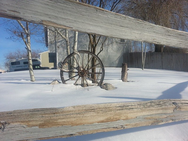
Snow covers a Thornton yard early in the month of March. (LE Worley)
The month of March is the start of meteorological spring and while conditions do begin warming, winter weather is certainly out of the question. From hot to cold, snow to rain, the conditions can be very conducive to great pictures as we see in our slideshow.
March in Denver typically means frequent and rapid weather changes. The days grow longer and we start enjoying more sunshine and sometimes summer-like weather. However, on occasion arctic air masses can still force their way south into Colorado dropping temperatures quickly and markedly.
With the active wildlife, increased outdoor activities by us humans, and of course the weather, March imagery contains a wide variety of subjects and extremes.
Slideshow updated March 29, 2015. To learn more about how to send your photo to us for inclusion in the slideshow, see below the slideshow.
Showcasing images captured by ThorntonWeather.com readers as well as some of our own, our monthly slideshow covers the entire gamut of weather-related imagery.
Sunsets, sunrises, wildlife and of course every type of weather condition are vividly depicted in images captured from yours and our cameras.
[flickr_set id=”72157651267455221″]
What is missing in the slideshow above? Your photo!
Our monthly photo slideshow is going to feature images that we have taken but more importantly images that you have captured. The photos can be of anything even remotely weather-related.
Landscapes, current conditions, wildlife, pets, kids. Whimsical, newsy, artsy. Taken at the zoo, some other area attraction, a local park, a national park or your backyard. You name it, we want to see and share it!
Images can be taken in Thornton, Denver or anywhere across the extraordinary Centennial State. We’ll even take some from out of state if we can tie it to Colorado somehow.
We’ll keep the criteria very open to interpretation with just about any image eligible to be shown in our slideshows.
What do you win for having your image in our slideshow? We are just a ‘mom and pop’ outfit and make no money from our site so we really don’t have the means to provide prizes. However you will have our undying gratitude and the satisfaction that your images are shared on the most popular website in Thornton.
To share you images with us and get them included in the slideshow just email them to us or share them with ThorntonWeather.com on any of the various social media outlets. Links are provided below.
 To go along with our Mother’s Day snow, we also have seen some cold – record-setting cold in fact.