Absolutely insane satellite imagery from CSU’s Cooperative Institute for Research in the Atmosphere (CIRA) of a dust storm as it moves south across northern Mexico this past Saturday.
Category Archives: World Weather
December 17 to December 23: This week in Denver weather history

Looking back at Denver weather history, it is readily apparent that the week leading up to Christmas has historically been a very eventful one. There are certainly many of the snow and wind events we would expect to see. Most notable however are the major winter storms like the pre-Christmas storm of 2006.
From the National Weather Service:
2-17
In 1939…more than 2 weeks of unseasonably warm weather made the month the 3rd warmest on record. Seven daily temperature records were set…including the all time record high temperature for the month of 79 degrees on the 5th. Daytime highs were balmy with 14 days in the 60’s and 70’s. Low temperatures dipped to freezing or below on only 5 days. The period was dry with only a trace of snow on the 12th.
16-17
In 1908…heavy snowfall totaled 7.9 inches in downtown Denver where north winds were sustained to 20 mph on the 17th. Temperatures were in the teens and 20’s.
In 1939…low temperatures of 49 degrees on the 16th and 43 degrees on the 17th were record high minimums for the dates. High temperatures of 65 on the 16th and 72 on the 17th were not records.
In 1980…Chinook winds blew through the night in Boulder with a peak reported gust to 75 mph. Northwest winds gusted to 30 mph at Stapleton International Airport on the 17th. The strong Chinook winds warmed temperatures to record daily highs of 70 degrees on the 16th and 73 degrees on the 17th.
In 2016…the presence of a warm and moist southwesterly flow aloft…overrunning an Arctic airmass with shallow post frontal upslope produced a band of very heavy snowfall across the Denver metro area. The enhanced band of heavy snow extended west into the Front Range mountains and foothills with snowfall rates up to 2 inches per hour. Multiple accidents occurred during the evening hours of the 16th as the snow quickly piled up. Three hundred flights were canceled at Denver International Airport as the winter storm moved through the Denver metro area early morning hours of the 17th. Storm totals in the Front Range mountains and foothills included: 16 inches at Loveland Ski Area; 12 inches near Conifer…11 inches at Winter Park Ski Area…10.5 inches at Bergen Park… 10 inches at Echo Lake…with 9.5 inches at Aspen Springs and Evergreen. In and around metro Denver…storm totals included: 11.5 inches in Wheat Ridge…11 inches in Arvada… 9 inches near Morrison…8 inches at Denver International Airport…Denver/Stapleton…Marston Reservoir and Ralston Reservoir; 7.5 inches in Westminster; 6.5 inches…5 miles northeast of Westminster; 6 inches in Aurora…5 miles west-northwest of Brighton…Englewood and near Louisville.
17
In 2000…high winds gusting from 60 to 74 mph howled across the northeast plains of Colorado. In Parker where winds gusted to 60 mph…a 20-foot by 40-foot piece of roof was ripped from a building. West winds gusted to 53 mph at Denver International Airport. This was the highest wind gust of the month at the airport. An intense…but very localized wind gust to 112 mph was measured near Georgetown Lake in the foothills west of Denver.
17-24
In 1924…a prolonged cold spell occurred after mild temperatures during the first half of the month. Most low temperatures dipped below zero with the coldest reading of 15 degrees below zero occurring on the 24th. The high temperature of only 5 degrees on the 18th was a record low maximum for the date.
18
In 1901…north winds were sustained to 52 mph with gusts to 58 mph behind an apparent cold front.
In 1973…a brief blizzard dumped heavy snow across metro Denver. Snowfall totaled 9.2 inches at Stapleton International Airport where north winds gusting to 53 mph produced much blowing snow. The storm forced many schools and businesses to close.
In 1996…a homeless man in Denver was found unconscious in his car suffering from exposure. The man’s body temperature was only 85 degrees when he was discovered. He died several hours later. Early morning temperatures had dipped to 9 degrees below zero.
In 1999…high winds were reported for a brief time in the foothills. Winds gusted to 72 mph in Golden Gate Canyon and to 71 mph at the National Center for Atmospheric Research in the foothills southwest of Boulder. West winds gusted to only 39 mph at Denver International Airport where the temperature warmed to a high of 53 degrees.
In 2002…only a trace of snow fell at the site of the former Stapleton International Airport. This…along with the trace of snow on the 5th…was the only snow of the month…ranking the month the 2nd least snowiest on record.
18-19 In 2012…a storm system brought moderate to heavy snow to the mountains and foothills west of metropolitan Denver and blizzard conditions to plains east of Denver metro area. The combination of snow and wind reportedly reduced visibility to just a few hundred feet at times…and resulted in several road closures including Interstate 70 east of Aurora. East of Denver gusty northerly winds ranged from 35 to 55 mph produced extensive blowing and drifting snow…ranging from 1 to 4 feet in depth. Storm totals ranged from 3 to 5 inches. In the mountain and foothills…the heaviest snowfall occurred along and north of I-70 and included: 12 inches at Genesee…9 inches near Eldorado Springs; 8.5 inches at Coal Creek Canyon…8 inches near Evergreen… with 6 inches at Eldora Ski Area…Idaho Springs… Gross Reservoir and Nederland. At Denver International Airport…1.7 inches of snowfall was observed. In addition…a peak wind gust to 35 mph was observed from the north on the 19th.
18-21
In 2010…a winter storm produced a 4-day period of moderate to heavy snow in the mountains. The combination of strong wind and heavy snow forced the closure of several mountain passes due to the threat of avalanches. The Amtrak train route… Which runs from Denver to California…was rerouted through Wyoming when Union Pacific closed its tracks along Interstate 70. Numerous accidents forced the closure of I-70 at times. The wind gusted to 60 mph over the higher mountain passes. Storm totals in the ski areas west of Denver ranged from 16 to 32 inches.
18-24
In 1998…a vigorous cold front with north winds gusting as high as 38 mph at Denver International Airport on the 18th dropped temperatures from a high of 51 degrees to a low of just 6 degrees before midnight. The arctic air mass that settled over metro Denver produced intermittent light snow and a week-long protracted cold spell that caused low temperatures to plunge well below zero for 6 consecutive nights. The coldest temperature was 19 degrees below zero on the morning of the 22nd. High temperatures climbed only into the single digits on 4 consecutive days…from the 19th through the 22nd. At least 15 people…mostly homeless… Were treated for hypothermia at area hospitals. The bitter cold weather was responsible…either directly or indirectly… For at least 5 fatalities. Three of the victims died directly from exposure. The cold weather also caused intermittent power outages. Following the cold snap… Thawing water pipes cracked and burst in several homes and businesses…causing extensive damage. Only one temperature record was set. The high temperature of only 7 degrees on the 19th set a record low maximum for the date. Continue reading December 17 to December 23: This week in Denver weather history
Deadly blizzards lash Europe, poor hardest hit
|
Snow falls in Rome as Europe hit by icy weather
|
Watch Beautiful Snow Tornado Blow Through a Picturesque Austrian Village
|
More Than 24 Million Affected by South Asia Flood Disasters
|
NOAA releases first images from new GOES satellite
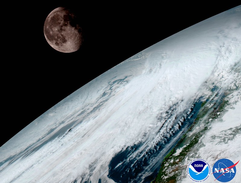
NOAA released the first images from their new GOES-16 satellite and to say they are stunning would be an understatement. The new satellite, built in Colorado by Lockheed Martin, contains some of the highest resolution cameras and most advanced sensors in the world.
From NOAA:
Since the GOES-16 satellite lifted off from Cape Canaveral on November 19, scientists, meteorologists and ordinary weather enthusiasts have anxiously waited for the first photos from NOAA’s newest weather satellite, GOES-16, formerly GOES-R.
The release of the first images today is the latest step in a new age of weather satellites. It will be like high-definition from the heavens.
- Scroll down to view all of the new images released by NOAA
The pictures from its Advanced Baseline Imager (ABI) instrument, built by Harris Corporation, show a full-disc view of the Western Hemisphere in high detail — at four times the image resolution of existing GOES spacecraft. The higher resolution will allow forecasters to pinpoint the location of severe weather with greater accuracy. GOES-16 can provide a full image of Earth every 15 minutes and one of the continental U.S. every five minutes, and scans the Earth at five times the speed of NOAA’s current GOES imagers.
NOAA’s GOES-16, situated in geostationary orbit 22,300 miles above Earth, will boost the nation’s weather observation network and NOAA’s prediction capabilities, leading to more accurate and timely forecasts, watches and warnings.
“This is such an exciting day for NOAA! One of our GOES-16 scientists compared this to seeing a newborn baby’s first pictures — it’s that exciting for us,” said Stephen Volz Ph.D. director of NOAA’s Satellite and Information Service. “These images come from the most sophisticated technology ever flown in space to predict severe weather on Earth. The fantastically rich images provide us with our first glimpse of the impact GOES-16 will have on developing life-saving forecasts.”
In May, NOAA will announce the planned location for GOES-16. By November 2017, GOES-16 will be operational as either GOES-East or GOES-West. Once operational, NOAA will use the satellite’s six new instruments to generate new or improved meteorological, solar, and space weather products.
Second satellite in GOES series already in development
Following on the heels of GOES-R will be, GOES-S, the second of four spacecraft in the series. GOES-S is undergoing environmental testing at Lockheed Martin’s Corporation facility in Littleton, Colorado, where it was built. A full set of environmental, mechanical and electromagnetic testing will take about one year to complete. The GOES-S satellite will be moved into the other operational position as GOES-17 immediately after launch and initial checkout of the satellite, approximately nine months after GOES-16.
| [flickr_set id=”72157679494723805″] |
2016 ‘Likely’ Hottest Year Ever: WMO
|
North Korea Floods Kill 133, Displace 107,000: U.N.
|
Typhoon Lionrock Predicted To Hit Japan
|
Typhoon Lionrock is expected to make landfall in Japan early in the week, according to reports. AccuWeather reported the storm will hit the coast of Japan as early as Monday night or Tuesday morning local time, and the heavy rainfall and intense winds could bring about three to six feet of storm surge. Lionrock’s interaction with… Continue reading Typhoon Lionrock Predicted To Hit Japan |