The start of meteorological fall has been highly eventful with record-setting high temperatures followed by virtually unprecedented rainfall. Four days of steady, sometimes heavy, rain has created hazardous conditions in many places along the Colorado Front Range including Thornton.
We will be monitoring monitoring the storm very closely and posting regularly to our Facebook page and Twitter feed. You can follow along in real time below. We are also on Google+ here.
This image from the Suomi NPP satellite’s VIIRS sensor from the evening of September 11, 2013, shows the storm system that has devastated towns in the foothills of the Rockies in central Colorado. Flash Flood Watches and Warnings are in effect throughout central Colorado, citing excessive runoff causing flash flooding of creeks and streams, roads and roadside culverts. The heavy rains could also trigger rock slides or debris flows in steep terrain. Major amounts of rain over the last several days have saturated soils in many foothill and Urban Corridor locations and additional rainfall in these locations today and tonight will only exacerbate an already serious situation. The High Park and Four Mile burn areas will be especially susceptible to the heavy rains. This image was taken around 2015Z on September 11, 2013. (NOAA)
* Click the image above for a larger view
Five days of rain, one with absolutely torrential downpours, created dangerous and deadly flooding across much of the Colorado Front Range. At one point the National Weather Service warned of ‘biblical rainfall amounts’ and it became hard to argue with that terminology. The rainfall amounts were truly astounding.
Boulder, where some of the worst flooding was seen, recorded 9.08” on Thursday, September 12. Estes Park, where the Big Thompson River flooded its banks, saw 3.9” over the 24 hour period.
Officially Denver only saw 1.1” on the date but that was as measured at Denver International Airport which only saw the edge of the storms. At the previous historical location in Stapleton, 3.68” was measured.
Here in Thornton we seemed to be right in line for the storms and generated one of the higher totals in the metro area accumulating 4.76” on the date. Since the rain started five days ago, we have received an amazing 7.66” (as of this writing).
Don’t miss a thing when it comes to our ever-changing weather! Be sure to ‘like’ us on Facebook, follow us on Twitter and add us to your Google+ circles.
A zoomed in view of the World Trade Center site as seen by astronauts on board the International Space Station on September 11, 2001. (NASA) Click the image for a larger view.
Twelve years ago today the United States of America was forever changed when war was brought to our own shores for the first time since Pearl Harbor. The imagery of that day still burns vividly in our memories and one from NASA shows the devastation of that day as seen from 200 miles above.
On that fateful day, crewmembers of the Expedition Three crew of the International Space Station were circling the globe.
Commander Frank L. Culbertson, Soyuz Commander Vladimir Dezhurov and Flight Engineer Mikhail Tyurin surely felt helpless as they passed over Ground Zero and could clearly see the plume of smoke emanating from the spot where so many people lost their lives.
The image they captured on that day was stunning – see below. While the World Trade Center was so far below, the devastation was so clear.
Our patriotism pulled us through those trying times and it shouldn’t take another attack to galvanize us in solidarity.
Today let us stand together to remember the victims of that horrible day.
Let us stand together and pay tribute to the lives of the thousands of men and women that have carried the battle forth since then and paid the ultimate sacrifice.
Let us stand together and honor the hundreds of thousands who wear our nation’s uniforms protecting us.
Let us never forget so that we and our children will never experience another day like 9/11.
NEVER FORGET!
Visible from space, a smoke plume rises from the Manhattan area after two planes crashed into the towers of the World Trade Center. This photo was taken of metropolitan New York City (and other parts of New York as well as New Jersey) the morning of September 11, 2001. “Our prayers and thoughts go out to all the people there, and everywhere else,” said Station Commander Frank Culbertson of Expedition 3, after the terrorists’ attacks. (NASA) Click the image for a larger view.
For the most part the Mile High City’s temperatures were on track to be pretty average this summer – up until the last half of August and first part of September. Since that time numerous high temperature records have been smashed and the number of days with temperatures over 90 degrees climbed.
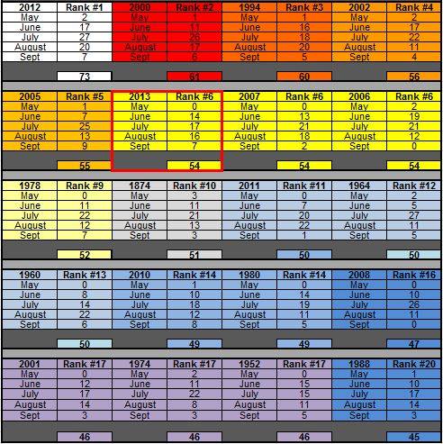
As measured at Denver International Airport, Denver has officially recorded 54 days this year with high temperatures at or above 90 degrees. This puts 2013 into the books as tied for 6th place with 2006 and 2007 for the number of 90 degree days.
On average Denver sees 40 90 degree days a year with the last one falling, on average, on September 4th. The latest we have seen a 90 degree day was on October 1, 1892.
The grid below, from the National Weather Service, shows the top 20 years of 90+ degrees with the monthly distributions.
How has Thornton fared by comparison? As usual we were cooler than the airport having recorded 47 days with 90 degree or higher temperatures. Of those, we recorded none in May, 10 in June, 14 in July, 16 in August, and 7 in September.
Certainly it is possible we could see those numbers increase before the year is out. However long term trends are toward cooler and wetter weather so it is likely we are done for this year.
The grid shows the Top 20 years of 90°+ in Denver along with the monthly distributions. (National Weather Service)
Thursday and Friday brought the hottest temperatures ever recorded during the month of September. Saturday we were spared making that mark again but we did tie a record.
The mercury at Denver International Airport topped out at 95 degrees at 3:07 p.m. This tied the record high temperature for the date of September 7th established in 1933.
Thornton saw very similar conditions to the airport. Our thermometer hit a high of 95.6 degrees.
This was the third record-setting day in a row for the Mile High City and every day so far this month except one (the 1st) has been punctuated by temperature exceeding 90 degrees.
Don’t miss a thing when it comes to our ever-changing weather! Be sure to ‘like’ us on Facebook, follow us on Twitter and add us to your Google+ circles.
For the second day in a row Denver’s temperature officially topped out at 97 degrees as measured at Denver International Airport smashing records once again.
The hot temperature tied the record for the hottest temperature ever recorded during the month of September, just as it did yesterday. It also sets a new record high for the date of September 6, easily besting the previous record of 95 degrees set in 1959.
Here in Thornton we were hotter than the airport as our temperature topped out at a sweltering 99.0 degrees. This was actually the second hottest temperature Thornton has recorded this year. Only June 11th was hotter at 99.2 degrees.
Don’t miss a thing when it comes to our ever-changing weather! Be sure to ‘like’ us on Facebook, follow us on Twitter and add us to your Google+ circles.
A good bit of cloud cover couldn’t keep the mercury from rising to mid-summer-like levels today. The hot temperatures in fact tied two records.
Denver’s temperature topped out a 97 degrees as measured at Denver International Airport. This tied the record high temperature for the date of September 5 set in 1899.
This also tied the record for the hottest temperature ever recorded during the month of September. The 97 degree mark has been recorded multiple times during the month, always within the first five days.
Here in Thornton the temperature we were actually a bit warmer than DIA, a rarity. We topped out at 98 degrees (97.6 degrees).
Unfortunately we will see no break in the 90+ degree weather until Monday at the earliest.
Don’t miss a thing when it comes to our ever-changing weather! Be sure to ‘like’ us on Facebook, follow us on Twitter and add us to your Google+ circles.
Recent weeks have delivered a number of hot days with temperatures routinely a good ways above normal. With the arrival of September 1 and the start of the meteorological fall, most in the Mile High City are hoping for some relief.
As temperatures start to drop, September usually reminds us that summer is at an end and fall is now here. Sunshine is predominant though as the month actually has the highest percentage of sun out of any month. Sunny days and clear, cool nights are the standard weather pattern for the month.
Current indications are that through the first half of the month temperatures are going to remain unseasonably warm. Precipitation-wise, we expect to see normal levels.
Looking back at last month we certainly do recall the unseasonably warm temperatures that seemed to dominate August 2013. While the high temperatures were indeed high, somehow Thornton managed to end up with a relatively average temperature and precipitation short of normal.
The month started with temperatures into the 90s and much-needed precipitation on two of the first three days. Thunderstorms on the third provided a bit of excitement including strong winds and some hail.
From there the month turned a good bit cooler with seasonal temperatures on many days and even two days (the 7th and 8th) when highs were in the 70s. The latter half of the month however saw a return of the heat with 13 of the final 16 days of the month registering high temperatures at or above 90 degrees.
Looking at the statistics one can easily see how different weather conditions can be across a relatively small area. While Thornton saw a monthly average temperature near normal, Denver was considerably warm. Similarly, our precipitation was below the Denver long term average but out at the airport it was well above average.
In terms of temperatures, the August average temperature in Thornton was 72.0 degrees. This was right near the 1981 to 2010 Denver average for the month of 72.5 degrees. Out at DIA however, the average temperature was a considerably higher 74.6 degrees.
Thornton’s highest temperature of the month was 97.6 degrees on the 20th. Our lowest was 50.2 degrees on the 15th. Officially, Denver’s highest temperature recorded was 99 degrees on the 20th and its lowest 52 degrees on that same day.
Three temperature records were broken in Denver during August 2013.
A new record high of 97 degrees was recorded on August 17 (96 degrees, 1994). On August 20 a record high of 99 degrees was recorded as well (98 degrees, 1987). Also on the 20th, a record high minimum of 70 degrees was set (67 degrees, 2007).
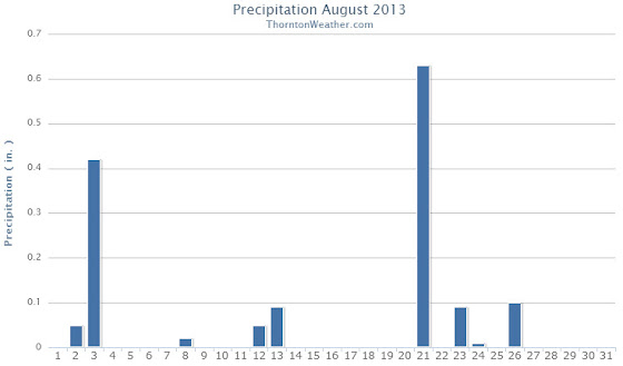
Denver’s long term precipitation for the month of August is 1.69 inches. Thornton fell short of that mark as we registered 1.37 inches in our rain bucket. More than an inch of that was the result of thunderstorms on two days (the 3rd and the 21st).
Denver was able to best us by a large margin recording 2.78 inches of precipitation in August 2013. The bulk of the Mile High City’s precipitation fell on the 22nd when they registered 1.94 inches from a slow moving thunderstorm, one which missed Thornton entirely.
One precipitation record was set in Denver during August 2013. The 1.94 inches of rainfall on the 22nd was a record for the date, easily besting the old record of 0.75 inches set in 1953.
Thornton, Colorado August 2013 Temperatures.Thornton, Colorado August 2013 Precipitation.
...THE DENVER CO CLIMATE SUMMARY FOR THE MONTH OF AUGUST 2013...

CLIMATE NORMAL PERIOD 1981 TO 2010
CLIMATE RECORD PERIOD 1872 TO 2013

WEATHER         OBSERVED          NORMAL  DEPART  LAST YEAR`S
                 VALUE   DATE(S)  VALUE   FROM    VALUE  DATE(S)
                                          NORMAL
................................................................
TEMPERATURE (F)
RECORD
 HIGH             105   08/08/1878
 LOW               40   08/26/1910
                        08/25/1910
                        08/24/1910
HIGHEST            99   08/20       105      -6       98  08/27
                                                          08/03
                                                          08/06
LOWEST             52   08/09        40      12       47  08/17
AVG. MAXIMUM     89.4              87.2     2.2     91.0
AVG. MINIMUM     59.8              57.9     1.9     58.9
MEAN             74.6              72.5     2.1     75.0
DAYS MAX >= 90     16              11.5     4.5       20
DAYS MAX <= 32      0               0.0     0.0        0
DAYS MIN <= 32      0               0.0     0.0        0
DAYS MIN <= 0       0               0.0     0.0        0

PRECIPITATION (INCHES)
RECORD
 MAXIMUM         5.85   1979
 MINIMUM         0.02   1924
TOTALS           2.78              1.69    1.09     0.11
DAILY AVG.       0.09              0.05    0.04     0.00
DAYS >= .01         7               8.6    -1.6        1
DAYS >= .10         2               4.3    -2.3        1
DAYS >= .50         2               1.2     0.8        0
DAYS >= 1.00        1               0.3     0.7        0
GREATEST
 24 HR. TOTAL    1.95   08/21 TO 08/22           08/11 TO 08/11
                                                          08/10 TO 08/11
                                                          08/11 TO 08/11
 STORM TOTAL       MM                                 MM
 (MM/DD(HH))            MM                    08/11(00) TO 08/11(00)
                                                 08/11(00) TO 08/11(00)1
                                                 08/11(00) TO 08/11(00)1

SNOWFALL (INCHES)
RECORDS
 TOTAL             MM   MM
TOTALS            0.0               0.0

DEGREE_DAYS
HEATING TOTAL       0                10     -10        0
 SINCE 7/1          0                16     -16        0
COOLING TOTAL     308               244      64      319
 SINCE 1/1        866               688     178     1122

FREEZE DATES
RECORD
 EARLIEST     09/08/1962
 LATEST       06/08/2007
EARLIEST                        10/07
LATEST                          05/05
..................................................

WIND (MPH)
AVERAGE WIND SPEED              8.8
RESULTANT WIND SPEED/DIRECTION   3/204
HIGHEST WIND SPEED/DIRECTION    43/110    DATE  08/03
HIGHEST GUST SPEED/DIRECTION    55/060    DATE  08/03

SKY COVER
POSSIBLE SUNSHINE (PERCENT)   MM
AVERAGE SKY COVER           0.60
NUMBER OF DAYS FAIR            4
NUMBER OF DAYS PC             23
NUMBER OF DAYS CLOUDY          4

AVERAGE RH (PERCENT)     48

WEATHER CONDITIONS. NUMBER OF DAYS WITH
THUNDERSTORM              0     MIXED PRECIP               0
HEAVY RAIN                2     RAIN                       3
LIGHT RAIN               11     FREEZING RAIN              0
LT FREEZING RAIN          0     HAIL                       0
HEAVY SNOW                0     SNOW                       0
LIGHT SNOW                0     SLEET                      0
FOG                       4     FOG W/VIS <= 1/4 MILE      2
HAZE                     10

-  INDICATES NEGATIVE NUMBERS.
R  INDICATES RECORD WAS SET OR TIED.
MM INDICATES DATA IS MISSING.
T  INDICATES TRACE AMOUNT.
While there has been no shortage of heat, we have avoided any records for the past two weeks – until Tuesday.
Yesterday the coldest temperature registered at Denver International Airport during the 24 hour period was only 68 degrees. This sets a new record high minimum for September 3, breaking the old record of 67 degrees set in 1947.
Here in Thornton we were a bit cooler with a low of 66 degrees at 6:44am.
The hot weather will continue through the weekend before we may see at least a bit of relief. The ridge is expected to start to break down Tuesday ushering cooler temperatures, particularly on Wednesday. Keep an eye on the forecast here for details.
Don’t miss a thing when it comes to our ever changing weather! Be sure to ‘like’ us on Facebook, follow us on Twitter and add us to your Google+ circles.
Weather, natural disasters & climate news and information.
 The start of meteorological fall has been highly eventful with record-setting high temperatures followed by virtually unprecedented rainfall. Four days of steady, sometimes heavy, rain has created hazardous conditions in many places along the Colorado Front Range including Thornton.
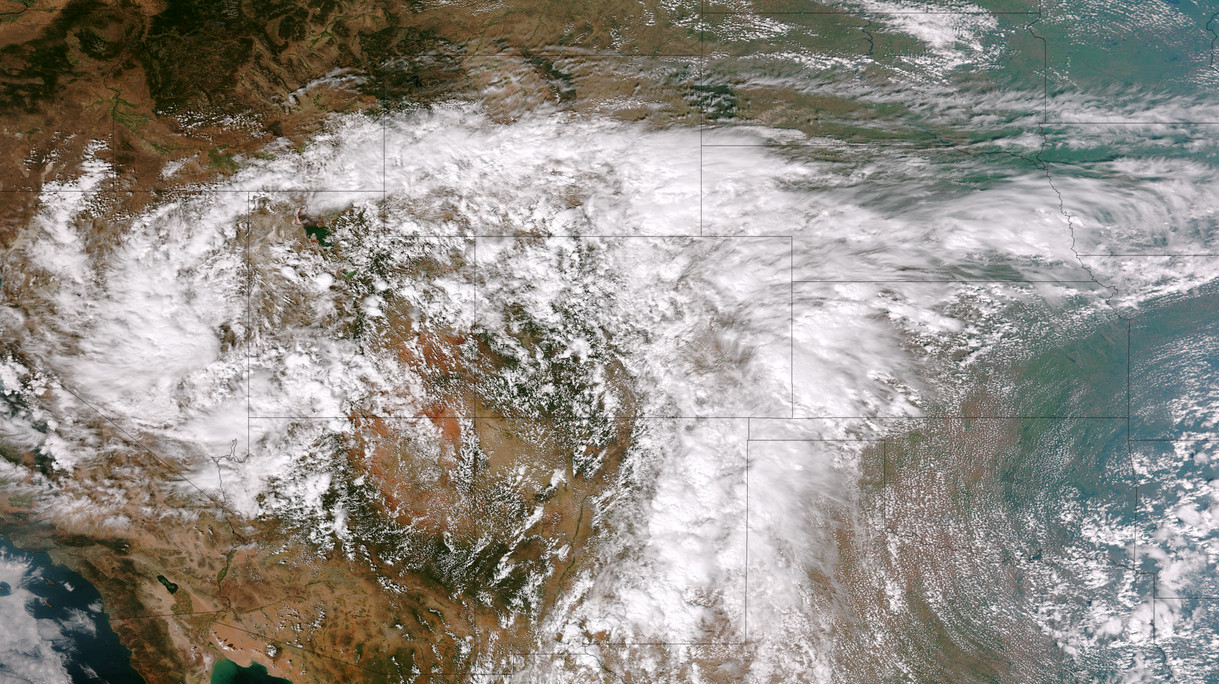


 Thursday and Friday brought the hottest temperatures ever recorded during the month of September. Saturday we were spared making that mark again but we did tie a record.