Category Archives: Thornton Weather

Photo slideshow: Colorado’s autumn colors and weather

Golden leaves, green pine, and blue sky in Pike National Forest. See more images of the autumn weather and colors in the slideshow below.  (ThorntonWeather.com)
Golden leaves, green pine, and blue sky in Pike National Forest. See more images of the autumn weather and colors in the slideshow below. (ThorntonWeather.com)

The changing of the seasons into fall brings with it some of Colorado’s most pleasant – and varied – weather conditions.  Certainly the autumn colors are oftentimes the highlight but many other types of beauty abound.

Just as summer was coming to a close we of course witnessed the devastating floods across northeastern Colorado.  As fall began, the weather – thankfully – turned much more benign.

The higher parts of the mountains began to see the leaves change at the end of September.  That was accompanied by snowfall which made for some stark and amazing photos.

Gorgeous moonrises and sunrises wrapped up the month and as we started out October, snow entered the forecast for the Thornton area.  While we received little more than a dusting (0.8”), it was enough to count as our first snowfall.

As colder temperatures set in, lower elevations of the high country and foothills began to see their colors change.  Here in town, trees are slowly beginning to turn golden.

The images below were taken by some of ThorntonWeather.com’s fans and shared with us as well as some we have taken ourselves.

If you capture any images of the season, please email them to info@thorntonweather.com or post them to our Facebook page.  We would love to add them.

  • Slideshow updated 10/26/13

Denver ties record low temperature for October 4

Record Cold TemperaturesWith a Freeze Warning in place following yesterday’s cold front, we knew it was going to be cold and it certainly has been.  In fact, it was record-setting.

Just before midnight, the mercury at Denver International Airport dropped to 28 degrees.  This tied the record low temperature for the date, October 4, last set 136 years ago in 1877.

Thornton nearly matched the official Denver numbers with a low of 28.5° recorded at 11:57 p.m.  This was our coldest reading since May 3.

The storm system that moved through brought snow to a good part of the Denver metro area.  Here in Thornton we measured 0.8”, our first snowfall of the season.  A total 0.39″ of liquid precipitation (rain and snow melt) was recorded in our bucket.

Inexplicably, the National Weather Service is showing no snow was measured at DIA yesterday morning.  This despite the fact that numerous firsthand accounts and pictures posted to social media showed the airport did indeed have measureable snowfall.

We are reaching out to the NWS to get an explanation for the discrepancy and will update this post if / when we receive a response.

  • Don’t miss a thing when it comes to our ever-changing weather! Be sure to ‘like’ us on Facebook, follow us on Twitter and add us to your Google+ circles.

September 28 to October 5: This Week in Denver Weather History

This Week In Denver Weather History
September 28 to October 5: This Week in Denver Weather History

While it appears Denver will escape September snow, our look back at this week in weather history shows that isn’t always the case. Additionally, while not common, even early fall can bring severe weather with damaging wind, lightning and even tornadoes.

From the National Weather Service:

28-29

In 1959…one of the heaviest September snow storms of record began as rain and changed to heavy wet snow. The storm caused heavy damage to trees and shrubbery…which were still in full leaf. The storm dumped 10.6 inches of snow at Stapleton Airport…the third heaviest September snow amount to date. Falling trees and limbs disrupted traffic…broke power and communication lines…and damaged buildings and cars. One man was killed in Denver by a falling tree limb…and four others died of heart attacks while shoveling snow or trying to move heavy tree limbs. Direct costs of the storm for cleaning up debris…repairing utility lines…and damage to buildings and other property across all of eastern Colorado were estimated to be over a half million dollars. The value of trees destroyed or damaged was estimated to exceed five million dollars. North-northeast winds gusted to 32 mph at Stapleton Airport on the 28th.

In 1985…an unusually cold air mass for this time of year settled over the area. Metro Denver received 8 to 12 inches of powdery snow. The 8.7 inches of snow that fell at Stapleton International Airport was the first measurable snow of the season and the city’s heaviest September snowfall since 1971. The snow caused flight delays of over 2 hours at Stapleton International Airport. I-70 was closed for a time west of Denver. Snow-laden tree limbs snapped over all of metro Denver…causing widespread power outages. Ten thousand people were without electricity for a time in Boulder. The morning of the 29th saw mid-winter temperatures along the Front Range. The temperature dipped to 17 degrees…the lowest temperature ever recorded in September in Denver. The high temperature of only 29 degrees on the 29th was a new record low maximum for the date and lowest ever recorded during the month of September. The low temperature of 21 degrees on the evening of the 28th set a new record low for the date. The cold weather persisted through the 1st with record minimum temperatures of 25 degrees set on the 30th and 27 degrees set on October 1st.

29

In 1966…a vigorous cold front moved thru metro Denver. North winds gusting to 51 mph kicked up billows of blowing dust…which briefly reduced the visibility to 1 mile at Stapleton International Airport. The cold air caused temperatures to drop rapidly from a high of 86 degrees to a low of 46 degrees by days end.

In 1985…the lowest temperature ever recorded in September… 17 degrees…occurred. The high temperature warmed to only 29 degrees…the all-time record low maximum for the month.

In 1994…the temperature reached a high of 91 degrees at Stapleton International Airport. This was the 60th day of the year that the temperature had reached 90 degrees or more…establishing a new record at that time. The previous record of 52 “90 degree days” occurred in 1978. Only 43 “90 degree days” were recorded at Denver International Airport during 1994.

In 1995…lightning struck a couple in Aurora as they were walking in the rain. The bolt struck the umbrella the man was carrying…injuring both the man and his wife.

In 2000…late afternoon thunderstorms produced strong wind gusts to 76 mph in Westminster…to 69 mph near Boulder…and to 60 mph at Jefferson County Airport near Broomfield. No damage was reported.

30

In 1898…south winds were sustained to 41 mph with gusts to 54 mph.

In 1940…a late season thunderstorm in the city caused one lightning death.

In 1944…the month ended with a trace of rain on this date and for the month. A trace of rain also occurred on the 4th…9th…and 10th. There was no measurable precipitation for the month. The total of a trace of precipitation for the month equaled the driest September on record first set in 1892.

In 2009…a trained spotter in Coal Creek Canyon…recorded a peak wind gust to 88 mph.

Continue reading September 28 to October 5: This Week in Denver Weather History

Thornton’s October weather preview: First freeze, first snow usually coming

Thornton, Colorado October weather preview.With the first full month of fall here, October usually brings one of the quietest weather months in the Denver area with plenty of mild, sunny days and clear, cool nights.

October is historically the second sunniest month and conditions are generally calm.

However we also will usually see our first taste of winter during the month with the first freeze and first snowfall of the season.  Temperatures as well will start to drop and by the end of the month the average nighttime lows are below freezing.

For complete details on our historical October weather and what we can expect in the coming month, read our complete October weather preview here.

  • Don’t miss a thing when it comes to our ever-changing weather! Be sure to ‘like’ us on Facebook, follow us on Twitter and add us to your Google+ circles.

September 2013 weather recap: Above normal temps, record-setting rainfall

[pe2-image src=”http://lh3.ggpht.com/-s4FTglN9w8U/UjWvCPnJ1FI/AAAAAAAAAhU/VSkx7UO17jE/s144-c-o/006.jpg” href=”https://picasaweb.google.com/108306177534978229224/September2013ColoradoSFloods?authkey=Gv1sRgCOa7nK-5oPKyvQE#5923833337961108562″ caption=”South Platte River at 100th & McKay road breaching its banks and flowing into the Sprat Lakes on September 12, 2013. (Ed Dalton)” type=”image” alt=”006.jpg” pe2_single_image_size=”w300″ pe2_img_align=”right”  ]

As we close the books on September 2013, the month featured its usual variety of weather but there is only one thing it will be remembered for:  rain!

The month opened with temperatures well above normal.  In fact, Denver recorded high temperature records three times in the first seven days.

Soon after however, the picture changed dramatically.  The ridge that had kept us so warm at the start of the month moved east and low pressure remained over Nevada.  This allowed a monsoonal-type flow of moisture to settle in and remain stubbornly in place for days on end.

Heavy rain became the rule starting on the 9th with showers persisting for six of the next seven days.  Thornton and all of the Denver metro area recorded extraordinary amounts while areas closer to the foothills were absolutely pounded.

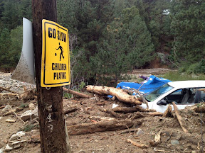
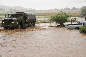
The ensuing floods were devastating for many places along rivers and streams.  Thornton weathered the storm relatively well with some minor flooding.  Other communities stretching from the foothills to the northeastern plains weren’t so lucky.

The month closed out with relatively typical September weather.  Most days were mild but there were a few more showers and some colder temperatures as well.

In terms of temperatures, Thornton saw a monthly average of 64.3 degrees.  This was almost a full degree warmer than the Denver long-term average of 63.4 degrees.  The Mile High City, as measured at DIA, was as usual a good bit warmer with a September 2013 average of 66.4 degrees.

Neither location was warm enough to make it into the list of top 10 warmest Septembers.  The number ten spot is 66.6 degrees.

We recorded 7 days with temperatures at or above 90 degrees.  This matched the number Denver recorded.

Thornton saw a high monthly temperature of 99.0 degrees and a low of 33.2 degrees.  Denver’s temperatures ranged from 97 degrees down to a low of 38 degrees.

Officially Denver recorded set or tied three record high temperatures:

  • September 5, 97 degrees, tied record high last set in 1899.
  • September 6, 97 degrees, breaks old record high of 95 degrees set in 1959.
  • September 7, 95 degrees, tied record high last set in 1933.

Precipitation was of course the big story for the month and Thornton saw more rain in the month than we have ever recorded at ThorntonWeather.com since coming online in October 2006.  By the time September came to a close, we had already bested our top year – with three months to go in 2013.

Thornton recorded a total of 10.15 inches of precipitation.  The majority of that, 8.84 inches, fell between the 9th of the month and the 15th.  One day, the 11th, dropped 4.76 inches in the rain bucket alone.

For Denver, we once again witnessed the problems with the official station being moved to Denver International Airport.  While they did record an abnormally high amount, it lagged other areas closer to town, including at the old Stapleton site.

Denver’s records will show 5.61 inches, well above the September normal of 0.96 inches.  That also is enough to put September 2013 into the history books as the wettest September in Denver history.  The old record holder was September 1961 with 4.67 inches.

Three daily precipitation records were set at DIA:

  • September 12, 1.11 inches, breaks old daily rain record of 0.95 inches set in 2012
  • September 14, 2.01 inches, breaks old daily rain record of 0.61 inches set in 1912
  • September 23, 0.64 inches, breaks old daily rain record of 0.52 inches set in 2000

No snow fell in September for the 13th year in a row.  This ties the record for the longest snow-less September streak with the periods from 1914 through 1926 and from 1882 to 1894.  The last time we saw September snow was in 2000 when 0.2” fell.  The month averages 1.3 inches.

Click here to view Thornton’s September 2013 climate summary report.

Looking back – Top stories from the September 2013 floods

[pe2-image src=”http://lh3.ggpht.com/-mk2_HTFl7bI/UktlyYkmEQI/AAAAAAAAAwY/a56KaoOMF0Q/s144-c-o/Sept-Temps.jpg” href=”https://picasaweb.google.com/108306177534978229224/Misc?authkey=Gv1sRgCNPjmpm5l5PSOA#5929945250627195138″ caption=”Thornton, Colorado September 2013 temperatures.” type=”image” alt=”Sept-Temps.jpg” pe2_single_image_size=”w560″ pe2_img_align=”none” ]

 [pe2-image src=”http://lh3.ggpht.com/-AEI7PqNjsFo/UktlyUJaioI/AAAAAAAAAwU/tglbcxtvlQo/s144-c-o/Sept-Precip.jpg” href=”https://picasaweb.google.com/108306177534978229224/Misc?authkey=Gv1sRgCNPjmpm5l5PSOA#5929945249439451778″ caption=”Thornton, Colorado September 2013 precipitation.” type=”image” alt=”Sept-Precip.jpg” pe2_single_image_size=”w560″ pe2_img_align=”none” ]

CLIMATE REPORT
NATIONAL WEATHER SERVICE BOULDER, CO
240 AM MDT TUE OCT 1 2013

......THE DENVER CO CLIMATE SUMMARY FOR THE MONTH OF SEPTEMBER 2013...

CLIMATE NORMAL PERIOD 1981 TO 2010
CLIMATE RECORD PERIOD 1872 TO 2013

WEATHER         OBSERVED          NORMAL  DEPART  LAST YEAR`S
                 VALUE   DATE(S)  VALUE   FROM    VALUE  DATE(S)
                                          NORMAL

TEMPERATURE (F)
RECORD
 HIGH              97   09/06/2013
                        09/05/2013
                        09/04/1995
 LOW               17   09/29/1985
HIGHEST            97R  09/06        97       0       95  09/01
                        09/05
LOWEST             38   09/28        17      21       45  09/28
                                                          09/22
AVG. MAXIMUM     78.6              78.5     0.1     80.3
AVG. MINIMUM     54.2              48.3     5.9     52.3
MEAN             66.4              63.4     3.0     66.3
DAYS MAX >= 90      7               3.4     3.6        7
DAYS MAX <= 32      0               0.0     0.0        0
DAYS MIN <= 32      0               0.8    -0.8        0
DAYS MIN <= 0       0               0.0     0.0        0 

PRECIPITATION (INCHES) 
RECORD 
 MAXIMUM         4.67   1961 
 MINIMUM            T   1892           
                        1944 

TOTALS           5.61R             0.96    4.65     2.95 
DAILY AVG.       0.19              0.03    0.16     0.10 
DAYS >= .01        10               6.5     3.5        5
DAYS >= .10        10               3.3     6.7        3
DAYS >= .50         3               0.6     2.4        3
DAYS >= 1.00        2               0.1     1.9        1
GREATEST
 24 HR. TOTAL    2.39   09/14 TO 09/15           09/25 TO 09/26
                                                          09/07 TO 09/07
                                                          09/07 TO 09/07
 STORM TOTAL       MM                                 MM
 (MM/DD(HH))            MM                    09/26(00) TO 09/26(00)
                                                 09/07(00) TO 09/07(00)7
                                                 09/07(00) TO 09/07(00)7

SNOWFALL (INCHES)
RECORDS
 TOTAL             MM   MM
TOTALS            0.0               1.3

DEGREE_DAYS
HEATING TOTAL      83               125     -42       69
 SINCE 7/1         83               141     -58       69
COOLING TOTAL     133                76      57      113
 SINCE 1/1        999               764     235     1235

FREEZE DATES
RECORD
 EARLIEST     09/08/1962
 LATEST       06/08/2007
EARLIEST                        10/07
LATEST                          05/05

WIND (MPH)
AVERAGE WIND SPEED              9.2
RESULTANT WIND SPEED/DIRECTION   2/183
HIGHEST WIND SPEED/DIRECTION    45/220    DATE  09/22
HIGHEST GUST SPEED/DIRECTION    64/220    DATE  09/22

SKY COVER
POSSIBLE SUNSHINE (PERCENT)   MM
AVERAGE SKY COVER           0.50
NUMBER OF DAYS FAIR            8
NUMBER OF DAYS PC             14
NUMBER OF DAYS CLOUDY          8

AVERAGE RH (PERCENT)     59

WEATHER CONDITIONS. NUMBER OF DAYS WITH
THUNDERSTORM              0     MIXED PRECIP               0
HEAVY RAIN                5     RAIN                       8
LIGHT RAIN               15     FREEZING RAIN              0
LT FREEZING RAIN          0     HAIL                       0
HEAVY SNOW                0     SNOW                       0
LIGHT SNOW                0     SLEET                      0
FOG                      12     FOG W/VIS <= 1/4 MILE      4
HAZE                      1

-  INDICATES NEGATIVE NUMBERS.
R  INDICATES RECORD WAS SET OR TIED.
MM INDICATES DATA IS MISSING.
T  INDICATES TRACE AMOUNT.

Gorgeous Colorado sunrise follows early morning crescent moon (Photos)

One of the benefits of being early risers like we are is that we oftentimes get to see what many others sleep through.  Those that had their eyes closed just before the sunrise and as it came up, missed quite a show.  Here are a few shots we took this morning.

[pe2-image src=”http://lh4.ggpht.com/-Li1oR3QnB5M/Ukh9XPB3CJI/AAAAAAAAAvU/sc3NElEWgcM/s144-c-o/twe1.jpg” href=”https://picasaweb.google.com/108306177534978229224/09292013MoonAndSunrise#5929126747558054034″ caption=”A pre-dawn crescent moon started the morning’s show. (ThorntonWeather.com)” type=”image” alt=”twe1.jpg” pe2_single_image_size=”w580″ pe2_img_align=”none” ] [pe2-image src=”http://lh5.ggpht.com/-6addX2X_SQA/Ukh9XOH4_3I/AAAAAAAAAvM/FQIPjtF-0qI/s144-c-o/twe3.jpg” href=”https://picasaweb.google.com/108306177534978229224/09292013MoonAndSunrise#5929126747314913138″ caption=”Old Glory and a gorgeous Colorado sunrise – it doesn’t get much better than that. (ThorntonWeather.com)” type=”image” alt=”twe3.jpg” pe2_single_image_size=”w580″ pe2_img_align=”none” ] [pe2-image src=”http://lh3.ggpht.com/-P0xuLDep-Lc/Ukh9XMaqy7I/AAAAAAAAAvQ/D3uQw9rSZmc/s144-c-o/twe2.jpg” href=”https://picasaweb.google.com/108306177534978229224/09292013MoonAndSunrise#5929126746856803250″ caption=”The sky was bathed in orange and blue at the start of the day. (ThorntonWeather.com)” type=”image” alt=”twe2.jpg” pe2_single_video_size=”w400″ pe2_gal_align=”none” pe2_img_align=”none” ]

A record-setting day of rain makes September 2013 the wettest September on record

Record Rain
Our wet September notched two more records into the books.

Overnight showers that lasted into the morning set a daily rainfall record in Denver.  Even more notable, the rain added to the monthly total making this the wettest September ever recorded in the Mile High City.

As measured at Denver International Airport, Denver recorded 0.64 inches of rain today.  This is a new daily record for September 23, beating the old record of 0.52 inches set in 2000.

Today’s rain, coupled with rainfall before midnight, brought Denver’s September monthly total to 5.47 inches.  With that, September 2013 will go into the record books as the wettest September on record.  The old monthly record was 4.67 inches set in 1961.

Denver’s rainfall total, while impressive, hardly compares to what has been seen in other locations.  It also once again highlights how the station at DIA hardly represents the weather conditions seen in the metro area and makes historical comparisons somewhat invalid.

At the CO-OP station at Stapleton where Denver’s official weather measurements were taken from 1950 to 1995, the monthly total is at 9.08 inches.  The difference in rainfall totals between the old location and DIA showcases how the station move to a different microclimate has skewed the Mile High City’s climate records.

Here in Thornton, our monthly total stands at 9.98 inches after receiving 1.15 inches over the past 24 hours.

Boulder, where some of the heaviest rains fell this month, was at 17.24 inches for the month before last night’s rain.  Monthly rainfall totals in many locations across the Denver metro area are pushing the 10 inch mark.

There are of course still seven days left in the month and with showers in the forecast later this week, that record-setting total may increase.

  • Don’t miss a thing when it comes to our ever-changing weather! Be sure to ‘like’ us on Facebook, follow us on Twitter and add us to your Google+ circles.

Interactive map: Rainfall totals from Colorado’s September 2013 flood event

Damage in Jamestown on September 15, 2013. (Boulder OEM)
Damage in Jamestown on September 15, 2013. See the map of rainfall totals from the flooding event below. Click the image to view a photo slideshow of the devastation. (Boulder OEM)

By the numbers, the rainfall experienced across northeastern Colorado since Monday, September 9 has been nothing short of extraordinary.  Over the span of a week, many locations received half of what they normally receive in an entire year.  Some received more than what they expect annually.

We have created and interactive map (below) that shows precipitation totals from Monday, September 9, 2013 to Monday, September 16, 2013.  The numbers are totals as reported by CoCoRaHS volunteers – the Community Collaborative Rain, Hail & Snow Network.

Looking at the map, it is clear that the Boulder area received the most with one station recording an astonishing 21.13” over the 7 day timespan.  The official station in Boulder has recorded 16.69” inches this month and 29.65” for the year. These numbers break Boulder’s monthly record and its annual precipitation record.

Denver’s official station at Denver International Airport (DIA) has recorded 4.65 inches this month, enough to put September 2013 in the books as the 2nd wettest on record.  However, that total hardly reflects what locations closer to the city’s center received with many recording over 7” this month.

Here in Thornton we have seen 8.85” of rain so far this month, an extraordinary total that brings our total for 2013 to 18.81”.  This is clearly the biggest month and year for precipitation since ThorntonWeather.com came online in 2007 and likely the biggest month ever in Thornton.

If you have a hard time viewing the map in the window below, click here to launch a larger version.

  • Don’t miss a thing when it comes to our ever-changing weather! Be sure to ‘like’ us on Facebook, follow us on Twitter and add us to your Google+ circles.

In pictures: Colorado’s record-setting September 2013 rains and flooding

Colorado National Guardsmen respond to floods in Boulder County, Colo., Sept.12, 2013. (Army National Guard Photo by Sgt. Joseph K. VonNida/RELEASED)
Colorado National Guardsmen respond to floods in Boulder County, Colo., Sept.12, 2013. See more images from Colorado’s devastating September 2013 floods in the slideshow below. (Army National Guard Photo by Sgt. Joseph K. VonNida/RELEASED)

September 2013 will forever be etched in the memory of all Coloradans as one which brought amazing destruction – and death.  Images of the truly historical event tell the story of the damage in the aftermath but also show the indomitable human spirit and the willingness of Americans to come together and help in times of need.

Northeastern Colorado has a surprisingly arid climate but also is an environment ripe for extreme weather events like the rain and floods we  experienced.

The cost and final death toll from the floods will be determined in the coming days, weeks and months but we know already this is one for the record books.

The September 2013 event lasted multiple days and effects were felt from the mountains and foothills to the flat eastern plains.  Many locations saw rainfall totals over four days equal to half of what they normally receive in an entire year.

The images in the slideshow below were gathered from a variety of sources.  If you have photos to share, please email them to info@thorntonweather.com and we will add them.

  • Don’t miss a thing when it comes to our ever-changing weather! Be sure to ‘like’ us on Facebook, follow us on Twitter and add us to your Google+ circles.
[flickr_set id=”72157697969563182″]