Thornton and Denver’s October 2013 was overall a relatively un-noteworthy month in terms of weather. Temperatures were below normal and we did receive our first measurable snowfall of the season.
We started the first two days of the month with temperatures in the 70s. That was followed by a cold front moving through and delivering 0.8” of snow in Thornton on the 4th while Denver recorded only a trace at DIA.
We then saw five days of dry conditions with temperatures warming back up into the 70s. On the 10th the next system arrived and rain was recorded on four of the next five days in Thornton. Cooler than normal temperatures were notable during the period and lasted for the next eight days.
On the 18th another shot winter-like weather arrived and Thornton saw its biggest snowfall yet of the season: 2.4 inches. Out at the airport, Denver recorded 1.4 inches.
The next nine days from the 19th to the 27th were largely pleasant days but with light rain on two days during that time. On the 28th another cold front and storm system moved in and chilly temperatures returned. Thornton recorded a dusting of snow on the 30th.
Overall temperatures for the month averaged 47.7 degrees as measured officially at DIA. Here in Thornton our average temperature was slightly cooler at 45.9 degrees. Both marks were considerably cooler than the historical October average temperature of 50.9 degrees.
Temperatures in Thornton ranged from a high of 79.5 degrees on the 8th down to a low of 25.5 degrees on the 16th. Denver’s high and low were similar with 79 degrees also on the 8th and 27 degrees on the 5th and 16th.
One temperature record was set in Denver during the month. On October 5 the low temperature reading of 28 degrees tied the record low for the date last set in 1877.
In terms of precipitation, Thornton recorded 1.21 inches between rainfall and snowmelt. Denver was drier recording only 0.72 inches. The Mile High City historically averages 1.02 inches so Thornton was above average, Denver below.
With only small snowfalls recorded, it wasn’t a particularly white month. Thornton measured a total of 3.3 inches while Denver recorded only 1.4 inches. Both were below the October average of 4.0 inches.
Click here to view Thornton’s October 2013 climate summary report.
[pe2-image src=”http://lh4.ggpht.com/-D-mSqpy-pQc/UnQi63nQ0FI/AAAAAAAAA3Q/_8y6TRKhmuE/s144-c-o/October2013Temps.jpg” href=”https://picasaweb.google.com/108306177534978229224/Misc?authkey=Gv1sRgCNPjmpm5l5PSOA#5941412203164913746″ caption=”Thornton’s October 2013 Temperatures.” type=”image” alt=”October2013Temps.jpg” pe2_single_image_size=”w560″ pe2_img_align=”left” ]
[pe2-image src=”http://lh5.ggpht.com/-d6PD6Dq3lto/UnQi_K0Q-dI/AAAAAAAAA3Y/L7pCMZAzn7E/s144-c-o/October2013Precip.jpg” href=”https://picasaweb.google.com/108306177534978229224/Misc?authkey=Gv1sRgCNPjmpm5l5PSOA#5941412277039200722″ caption=”Thornton’s October 2013 Precipitation.” type=”image” alt=”October2013Precip.jpg” pe2_single_image_size=”w560″ pe2_img_align=”left” ]
CLIMATE REPORT
NATIONAL WEATHER SERVICE BOULDER, CO
240 AM MDT FRI NOV 1 2013

...................................

...THE DENVER CO CLIMATE SUMMARY FOR THE MONTH OF OCTOBER 2013...

CLIMATE NORMAL PERIOD 1981 TO 2010
CLIMATE RECORD PERIOD 1872 TO 2013

WEATHER         OBSERVED          NORMAL  DEPART  LAST YEAR`S
                 VALUE   DATE(S)  VALUE   FROM    VALUE  DATE(S)
                                          NORMAL
................................................................
TEMPERATURE (F)
RECORD
 HIGH              90   10/01/1892
 LOW               -2   10/29/1917
HIGHEST            79   10/08        90     -11       83  10/03
LOWEST             27   10/16        -2      29       24  10/27
                        10/05
AVG. MAXIMUM     60.0              65.3    -5.3     62.2
AVG. MINIMUM     35.5              36.6    -1.1     35.9
MEAN             47.7              50.9    -3.2     49.0
DAYS MAX >= 90      0               0.0     0.0        0
DAYS MAX <= 32      0               0.4    -0.4        1
DAYS MIN <= 32     12               8.5     3.5       11
DAYS MIN <= 0       0               0.0     0.0        0

PRECIPITATION (INCHES)
RECORD
 MAXIMUM         4.17   1969
 MINIMUM            T   1934
TOTALS           0.72              1.02   -0.30     1.22
DAILY AVG.       0.02              0.03   -0.01     0.04
DAYS >= .01         8               5.3     2.7        5
DAYS >= .10         3               2.4     0.6        3
DAYS >= .50         0               0.5    -0.5        2
DAYS >= 1.00        0               0.1    -0.1        0
GREATEST
 24 HR. TOTAL    0.25   10/18 TO 10/18           10/24 TO 10/25
                        10/03 TO 10/04                    10/25 TO 10/25
                                                          10/25 TO 10/25
 STORM TOTAL       MM                                 MM
 (MM/DD(HH))            MM                    10/25(00) TO 10/25(00)
                                                 10/25(00) TO 10/25(00)5
                                                 10/25(00) TO 10/25(00)5

SNOWFALL (INCHES)
RECORDS
 TOTAL             MM   MM
TOTALS            1.4               4.0

DEGREE_DAYS
HEATING TOTAL     525               440      85      488
 SINCE 7/1        608               581      27      557
COOLING TOTAL       0                 5      -5        1
 SINCE 1/1        999               769     230     1236

FREEZE DATES
RECORD
 EARLIEST     09/08/1962
 LATEST       06/08/2007
EARLIEST      10/04             10/07
LATEST                          05/05
......................................................

WIND (MPH)
AVERAGE WIND SPEED              8.8
RESULTANT WIND SPEED/DIRECTION   1/180
HIGHEST WIND SPEED/DIRECTION    40/270    DATE  10/10
HIGHEST GUST SPEED/DIRECTION    48/270    DATE  10/10

SKY COVER
POSSIBLE SUNSHINE (PERCENT)   MM
AVERAGE SKY COVER           0.50
NUMBER OF DAYS FAIR           12
NUMBER OF DAYS PC             14
NUMBER OF DAYS CLOUDY          5

AVERAGE RH (PERCENT)     61

WEATHER CONDITIONS. NUMBER OF DAYS WITH
THUNDERSTORM              0     MIXED PRECIP               0
HEAVY RAIN                0     RAIN                       3
LIGHT RAIN                9     FREEZING RAIN              0
LT FREEZING RAIN          1     HAIL                       0
HEAVY SNOW                1     SNOW                       2
LIGHT SNOW                4     SLEET                      0
FOG                      13     FOG W/VIS <= 1/4 MILE      9
HAZE                      4

-  INDICATES NEGATIVE NUMBERS.
R  INDICATES RECORD WAS SET OR TIED.
MM INDICATES DATA IS MISSING.
T  INDICATES TRACE AMOUNT.
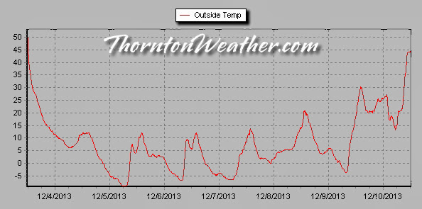
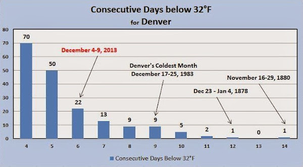

 Clear skies and snow cover helped push the mercury down early this morning. The result was a second record low temperature set in the past 24 hours.
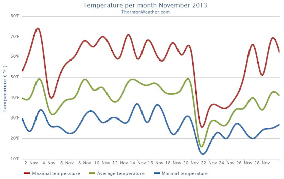
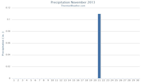
 November was an unseasonably warm and unusually dry month. As we look into December, that trend looks to change, particularly when it comes to temperatures.
 The weather during the month of November in Denver metro area can offer just about anything. While it is normally a quiet month, it can be prone to extremes.