It doesn’t feel much like Christmas with temperatures like this! Once again Denver saw unusually high temperatures and the result was the warmest December 25 on record.
As measured at Denver International Airport, the Mile High City saw a high temperature of 71 degrees. This bested the previously record high for the date of 69 degrees set in 2005.
Here in Thornton, we were warmer with a high of 74 degrees.
December 8, 2025 – A beautiful end to the day. (Al Feuerborn)
The month of December can offer everything from bone dry conditions to bone chilling cold and monstrous snowstorms. The weather and wildlife all afford an abundance of photo opportunities as our December photo slideshow shows.
Leaves have fallen from trees now and the landscape can sometimes look quite stark. However it only takes a quick shot of snow to change that picture greatly. Throw in gorgeous sunrises and sunsets, plenty of wildlife big and small, kids playing and much more and the month can be quite colorful and eventful.
Slideshow updated December 22, 2025
To learn more about how to send your photo to us for inclusion in the slideshow, see below the slideshow.
Showcasing images captured by ThorntonWeather.com readers as well as some of our own, our monthly slideshow covers the entire gamut of weather-related imagery.
Sunsets, sunrises, wildlife and of course every type of weather condition are vividly depicted in images captured from yours and our cameras.
What is missing in the slideshow above? Your photo!
Our monthly photo slideshow is going to feature images that we have taken but more importantly images that you have captured. The photos can be of anything even remotely weather-related.
Landscapes, current conditions, wildlife, pets, kids. Whimsical, newsy, artsy. Taken at the zoo, some other area attraction, a local park, a national park or your backyard. You name it, we want to see and share it!
Images can be taken in Thornton, Denver or anywhere across the extraordinary Centennial State. We’ll even take some from out of state if we can tie it to Colorado somehow.
We’ll keep the criteria very open to interpretation with just about any image eligible to be shown in our slideshows.
What do you win for having your image in our slideshow? We are just a ‘mom and pop’ outfit and make no money from our site so we really don’t have the means to provide prizes. However you will have our undying gratitude and the satisfaction that your images are shared on the most popular website in Thornton.
To share you images with us and get them included in the slideshow just email them to us or share them with ThorntonWeather.com on any of the various social media outlets. Links are provided below.
Cars are buried under the heavy snow in Denver. Scroll down for a photo slideshow with more images. (Denver Public Library Digital Collection)
As Christmas approaches everyone reflects on the past and for longtime Denver residents that oftentimes means remembering one of the most significant winter storms in the Mile High City’s history – the Christmas Eve Blizzard of 1982. This major winter storm has become the one by which all others are compared not only due to its record-setting impact but also due to its timing being near Christmas.
As Christmas 1982 approached, forecasters were predicting a white Christmas several days beforehand but most were expecting a moderate snowfall of 6 inches. Two days before Christmas Eve though, the picture began to change. On the 22nd a Pacific cold front came ashore in California bringing severe rain, high surf and even hurricane force winds. As it moved east over higher terrain, it dumped 2 feet of snow in the Wasatch Mountains near Salt Lake City.
At about that same time, jet stream winds were forming a trough of low pressure over the southeastern plains of Colorado. The counterclockwise motion of the trough began to pull moist air into the state. Further east Kansas and Oklahoma experienced severe thunderstorms and even tornadoes. The winds set the stage for strong upslope conditions along the Front Range.
Scroll down to the view photo slideshow from this famous snowstorm
Do you remember the Christmas Eve Blizzard of ’82? Leave a comment below with your memories
Rain changed to snow on the plains and shortly before midnight on the 23rd, a full blown blizzard had developed. Denver woke to snow on the ground the morning of Christmas Eve but the storm was just getting started. Snowfall rates of 2 – 3 inches per hour were the norm during the day and winds screamed at 50mph causing wind chill temperatures to plummet to as low as -35 degrees. As conditions continued to deteriorate throughout the day, the gravity of the situation began to be realized. Continue reading Looking back at an unforgettable holiday – Denver’s Christmas Eve Blizzard of 1982→
Fall-like temperatures continue right into the holidays with Denver setting another high temperature record.
As measured at Denver International Airport, the Mile High City saw a high temperature today of 71 degrees. This bests the previous record high for the date of 70 degrees set in 1955.
Here in Thornton, we were warmer with a high of 73 degrees.
While it will cool some on Christmas Day, there is the potential for us to set a record high for it as well. On December 25, 2005 we saw a high of 69 degrees.
The ridiculously warm temperatures this month have set another high temperature record.
As measured at Denver International Airport, the Mile High City saw a high temperature today of 76 degrees. This breaks the previous record high for December 22 of 70 degrees set in 1955.
The reading is also the second warmest December temperature ever recorded for Denver. December 5, 1939 holds the record with a reading of 79 degrees.
Here in Thornton, we were similarly warm with a high of 76 degrees.
Another mild day, another record warm temperature.
As measured at Denver International Airport, the Mile High City saw a high temperature today of 67 degrees. This ties the previous record high for December 19 last set in 1933.
Here in Thornton, we managed to stay cooler with a high of 63.7 degrees for the day.
The ridiculous warm temperatures have set a high temperature record for the date.
As measured at Denver International Airport, the Mile High City saw a high temperature today of 69 degrees. This breaks the previous record high for December 19 of 67 degrees.
Here in Thornton, we were even warmer with a high of 73 degrees.
The mild temperatures have put a record in the books for December 11.
As measured at Denver International Airport, the date saw a low temperature of 45 degrees. This breaks the previous record high minimum of 44 degrees for the date set in 1933.
Here in Thornton we were considerably warmer overnight and early morning. Our low temperatures as a mild 56.3 degrees.
Thornton, Colorado’s November 2025 Temperature Summary. (ThorntonWeather.com)
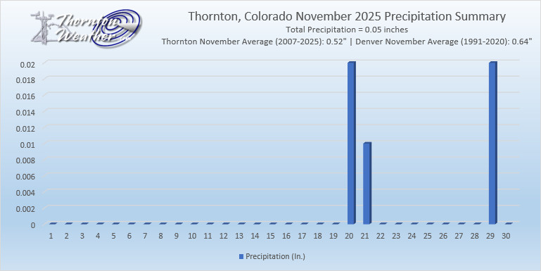
Yet another month in the books with mercury readings well above average and precipitation lighter than average. In fact, November 2025 goes into the books as the warmest and second driest November in Thornton of the past 19 years.
During the month there was a complete lack of notable weather events – beyond the warmth and dryness. It wasn’t until the third week of the month that we saw any precipitation and then it was a minimal amount of rain.
On the 28th, we finally received our first snowfall of the season, but it was a meager amount (0.6 inches). It also was the second latest first seasonal snowfall ever recorded in Denver.
Overall, Thornton’s November 2025 average temperature was 45.8 degrees. This is far above our 19-year running average temperature for November of 39.9 degrees. It also makes the month the warmest November recorded over that same period.
For Denver, as recorded at Denver International Airport, it was similarly mild. The average temperature was 45.1 degrees. This was 5.7 degrees above the city’s long-term average.
Precipitation was pitiful for the month. Thornton recorded a mere 0.05 inches during the month. This is far below our running average for November of 0.52 inches.
The Mile High City recorded 0.09 inches of precipitation in their bucket. This is far below Denver’s long-term average for November of 0.64 inches.
As previously stated, snow was virtually non-existent during the month. The 28th offered the first snow of the season in Thornton and only totaled 0.6 inches. The month’s total fell far short of our 19-year average of 5.9 inches.
Denver recorded only 0.2 inches of the white stuff at DIA. This was far below the 7.3 inch average for November in the Mile High City.
Recent months have, overall, been mostly warmer and drier than normal. What will December hold for us?
The month of December brings with it the official start of winter and oftentimes, colder and snowier weather conditions. It, however, can also offer unseasonably warm temperatures and bone dry conditions. Given our recent mild and dry weather, we are certainly hoping for a change in the coming month.
Overall December’s monthly mean temperature of 31.2 degrees (1991 – 2020 averages) makes it our coldest month. Snow is always on everyone’s mind this time of year but December is only our 3rd snowiest month behind March and November with an average of 8.0 inches of the white stuff.