Category Archives: Natural Disasters

Deadly cold envelops Northern Hemisphere from U.S. to China

Severe cold weather has enveloped the northern half of the globe from the United States to Britain to China. Across the continents, many places are reporting record setting temperatures and lives have been lost due to the Arctic chill.

The eastern half of the United States saw cold, Arctic air pulled down from the north plunging temperatures below freezing in normally mild places as far south as Florida. The widespread cold gripped most of the nation east of the Rocky Mountains to the Gulf of Mexico and the Atlantic Seaboard.

Across the Midwest, temperatures plunged to well below freezing as parts of Iowa recorded temperatures as low as -15 degrees. Jeff Johnson, National Weather Service meteorologist, told the Des Moines Register, “”We’re a solid 30 degrees below normal.” Minneapolis, Minnesota and Chicago, Illinois were seeing wind chills below 0 degrees Tuesday morning.

In Miami, residents accustomed to short sleeve shirts and shorts bundled up as temperatures dropped to freezing. Further north in the state, Orlando saw a low temperature of 21 degrees.

The National Weather Service issued hard freeze warnings across parts of Mississippi, Alabama, Georgia and Florida as the cold threatened the agriculture industry in those states. Freeze watches in Tennessee highlighted the severe cold and came on the heels of reports that four people have died in that state from the cold.

There's more to this story on Examiner.com!The United States is not alone as the cold has turned deadly across the globe.  Get all the details and see some amazing photos at the Natural Disasters Examiner.

Erupting deep sea volcano captured on film

Magma erupts from a newly discovered deep sea volcano. (NOAA)

An impressive display of the earth’s power was witnessed by scientists 4,000 feet below the surface of the Pacific Ocean. Scientists discovered the deepest erupting volcano yet and aided by the extreme pressure at that depth, they were able to send a remote controlled submersible within feet of it as it erupted.

Video of the event (click here) captured bubbles of magma as they shot into the ocean with a cloud of sulphur. The magma froze virtually instantly due to the extreme cold and fell to the surface as rock.

Co-Chief Scientist Bob Embley of the National Oceanic and Atmospheric Administration (NOAA) said, “It was an underwater Fourth of July – a spectacular display of fireworks nearly 4,000 feet deep.”

The mission featured a number of firsts in addition to the discovery of the volcano itself. For the first time scientists witnessed molten lava flowing across the ocean’s bottom and discovered a new type of lava.

NOAA said that the lava the volcano is producing has never before been seen on an active volcano. The Boninite lava is said to be the hottest erupting on earth in modern times. Scientists said it will allow a unique opportunity to learn how the earth recycles material when one tectonic plate subsides under another.

There's more to this story on the Denver Weather Examiner's site!Be sure to visit the Natural Disasters Examiner and watch the amazing video and view the incredible photos!

2009 likely to end with lowest level of natural disasters in a decade

Natural disasters in 2009 at lowest levels of the decade The number of natural disasters in 2009 reached the lowest point in the decade. According to preliminary numbers from the United Nations, there were 245 disasters which is far below any of the past 10 years.

Natural disasters, no matter how many there are, due have a toll in human life and economic impact. The UN International Strategy for Disaster Reduction (UNISDR) said that 8,919 people lost their lives from the events and they affected 58 million. The cost of the damage was put at $19 billion.

Weather-related disasters which exclude geological events like earthquakes and volcanoes were responsible for the lion’s share of the losses. Approximately 7,000 lives our of the total of 8,919 were lost due to weather-related events. Similarly, $15 billion of the $19 billion in damages were weather-related. 

Margareta Wahlström, the United Nations Special Representative for UNISDR said, “Statistics this year show lower figures compared to previous years, which is good news for people and countries, however extreme weather disasters remain top of the list and will continue to affect more people in the future as more than half of the world’s population highly exposed is living in coastal regions.”

There's more to this story on the Denver Weather Examiner's site!For the rest of the story including a look at the “top five” disasters of 2009, check out the story at the Natural Disasters Examiner.

CSU team forecasts above normal hurricane activity in 2010

The early forecast for the 2010 hurricane season in the Atlantic basin calls for above normal levels of activity. (NOAA)

The hurricane forecasting team at Colorado State University (CSU) has issued its preliminary forecast for the Atlantic hurricane basin for next year. Generated by Dr. Phil Klotzbach and Dr. Bill Gray, the forecast calls for above normal levels of tropical cyclone activity.

For the 2010 season, Klotzbach and Gray expect an “above-average Atlantic basin tropical cyclone season in 2010 and anticipate an above-average probability of U.S. and Caribbean major hurricane landfall.” In terms of numbers, they forecast 11 – 16 named storms, 6 – 8 hurricanes, and 3 – 5 major hurricanes (Category 3 or stronger).

An average Atlantic hurricane season has 10 – 11 named storms, 6 hurricanes, and 2 major hurricanes. The 2009 hurricane season wrapped up quite a bit below normal with the fewest storms since 1997.  Check out our slideshow below for images from the 2009 hurricane season. 

For the first time, the CSU team is issuing a range for the number of forecast storms instead of a specific number. This is more in line with the forecasts that the National Hurricane Center issues.

In terms of landfall probability for a major hurricane, the team also expects an increased chance. They peg the chance of a Category 3 or greater storm striking the U.S. coastline at 64% which is well above the average of 52%. The U.S. East Coast has a 40% chance of sustaining a hit (versus a 31% average) and the Gulf Coast has a 40% chance as well (versus a 30% average).

There's more to this story on the Denver Weather Examiner's site!For more details about the hurricane forecast, whether this is a sign of global warming and a slideshow of hurricanes from the 2009 season, please visit the Natural Disasters Examiner.

Hurricane season ends with lowest level of activity since 1997

Hurricane Bill was the most powerful hurricane of the 2009 Atlantic hurricane season but it never struck the United States. (NASA)

Yesterday marked the end of the 2009 hurricane season and with it comes to a close one of the quietest seasons in recent history. The season featured nine named storms, the fewest since 1997, and for the first time since 2006 no hurricanes made landfall in the United States.

Only two named the storms – Tropical Storm Claudette and Tropical Storm Ida – made landfall in the nation. Those two storms both struck along the central Gulf Coast and brought heavy rain and some flooding but no widespread destruction.

Of the nine named storms, three became hurricanes. Two of those became major hurricanes of Category 3 strength of higher – Hurricane Bill and Hurricane Fred. Bill flirted with the United States East Coast as its waves claimed two lives but turned to the northeast and made landfall in Newfoundland after having weakened considerably. Hurricane Fred rapidly intensified off the west coast of Africa but quickly fell victim to wind shear.

Of the nine named storms, three became hurricanes. Two of those became major hurricanes of Category 3 strength of higher – Hurricane Bill and Hurricane Fred. Bill flirted with the United States East Coast as its waves claimed two lives but turned to the northeast and made landfall in Newfoundland after having weakened considerably. Hurricane Fred rapidly intensified off the west coast of Africa but quickly fell victim to wind shear.

There's more to this story on the Denver Weather Examiner's site!For much more on this story including the tracks of the storms and amazing satellite imagery, please visit the Natural Disasters Examiner.
NASA satellite captures image of Russian volcano’s smoke

NASAs Terra satellite captured this image of a smoke plume coming from the Bezymianny volcano on the the Kamchatka Peninsula in Russia.
NASA's Terra satellite captured this image of a smoke plume coming from the Bezymianny volcano on the the Kamchatka Peninsula in Russia. (NASA)

The Kamchatka Peninsula in Russia is a relatively active area for volcanic activity, like much of the rest of the Pacific Ring of Fire. The Bezymianny volcano in the east-central part of the peninsula is the smaller of three neighboring volcanoes.

Bezymianny was thought to be extinct until it erupted from 1955 to 1956. Prior to that, it had experienced a period of 1,000 of dormancy. The 1956 eruption was comparable in size to the Mount Saint Helens eruption in 1980 and resulted in a horseshoe shaped crater that has since been filled by other, smaller eruptions and pyroclastic flows.

On Wednesday, Novebmer 25, 2009, NASA’s Terrra spacecraft captured an image of a smoke plume emanating from the volcano. Using the craft’s Advanced Spaceborne Thermal Emission and Reflection Radiometer (ASTER), the plume is clearly seen as is its shadow.

For a larger image of the volcano, please visit the Natural Disasters Examiner.
New movie ‘2012’ adds a new scale to the disaster movie genre

The new movie 2012 depicts natural disasters on a global scale. In the scene depicted above, the USS John F Kennedy is carried on a tsumani and about to crush the White House. (Columbia Pictures)
The new movie "2012" depicts natural disasters on a global scale. In the scene depicted above, the USS John F Kennedy is carried on a tsumani and about to crush the White House. (Columbia Pictures)

Natural disasters have long been a staple of the big screen and a new movie set to hit theatres this week takes the genre to a new height. “2012” by director Roland Emmerich depicts cataclysmic disasters on a global scale brought about on December 21, 2012 – the mythical end of the Mayan calendar.

Disaster movies have shown tornadoes, hurricanes, earthquakes and tsunamis but rarely has a film been made that included every type of disaster imaginable. “2012” brings all disasters together with scenes of California falling off into the ocean, fireballs raining from the sky, the Sistine Chapel collapsing on devout worshipers and even the aircraft carrier USS John F. Kennedy being dumped ashore on top of the White House by a giant wave.

An all-star cast featuring John Cusack, Danny Glover, Thandie Newton, Woody Harrelson, Chiwetel Ejiofor and Amanda Peet depict man’s struggle to survive the incredible calamity. As one of the movie’s fictional characters says, “Our mission is to ensure the continuity of our species.”

There's more to this story on the Denver Weather Examiner's site!For more about the movie, how it ties into the Mayan calendar and to watch the trailer, see the rest of this story on the Natural Disasters Examiner.

Predictions of climate change induced natural disasters falling flat

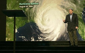
Former vice president Al Gore famously used an image of Hurricane Katrina to illustrate his argument that natural disasters will increase in intensity and frequency.  Empirical data howeverhas shown that is not the case. (An Inconvenient Truth)
Former vice president Al Gore famously used an image of Hurricane Katrina to illustrate his argument that natural disasters will increase in intensity and frequency. Empirical data howeverhas shown that is not the case. (An Inconvenient Truth)

Manmade climate change is said to present humankind with some of its greatest challenges in the planet’s history, not the least of which is an alarming increase in frequency and intensity of natural disasters. Massive flooding, super-powered hurricanes, endless tornado seasons and more have all been said to be the direst of consequences of global warming.

In his movie “An Inconvenient Truth”, Al Gore famously proclaimed that, “Temperature changes are taking place all over the world and that is causing stronger storms.” Standing with Hurricane Katrina as a backdrop, the former vice president issued a cautionary tale of disaster in the making, all due to our irresponsible handling of the atmosphere. As recently as February Mr. Gore was giving a presentation showing flooding, drought and wildfires saying, “This is creating weather-related disasters that are completely unprecedented.”

President Barack Obama, in a town hall meeting in April echoed the Nobel laureate’s comments saying, “You’re now looking at huge, cataclysmic hurricanes, complete changes in weather patterns.” He followed that in September when in a speech before the United Nations he claimed, “More powerful storms and floods threaten every continent.”

But what if you predicted global natural disaster catastrophes and they didn’t happen? Does that invalidate your entire message? This is the conundrum faced by climate change alarmists as many of their predictions begin to fall flat.

There's more to this story on the Denver Weather Examiner's site!Learn more about the evidence and find out why even some alarmists say these claims of ‘doom and gloom’ are hurting their case on Examiner.com.

Where are the tornadoes? 2009 tornado reports well below normal levels

Tornado activity so far in 2009 has been well below normal. This has researchers wondering what has happened to the tornadoes?

Tornado activity in the United States for 2009 is reaching unusually low levels according to statistics from NOAA’s Storm Prediction Center (SPC). By its latest count as of Sunday, November 1st, 1040 tornado reports have been received this year placing it in the 10th percentile since 1954 (see chart below).

Tornadoes occur in every month on the calendar but 2009 started with far below normal numbers for the first three months of the year. As the traditional severe weather season approached during the spring, tornado numbers returned to near average but have since fallen into a decline.

Similarly, tornado deaths in 2009 are far below the average. The three year running average from 2006 to 2008 saw an average of 91 fatalities per year. Over the longer term, the United States experiences 80 per year. Thus far in 2009 only 22 deaths have been reported as a result of twisters. There was nearly a five month period from May 13th to October 9th when there were no deaths at all recorded.

There's more to this story on the Denver Weather Examiner's site!Why so few tornadoes?  For some possible answers and how this ties into global climate change, get the full story on Examiner.com.

Hurricanes MIA – Tropical cyclone activity at 30-year low

Tropical cyclone activity continues to decline despite beliefs that it would increase as a result of global warming.  (NOAA)
Tropical cyclone activity continues to decline despite beliefs that it would increase as a result of global warming. (NOAA)

For the third year in a row, tropical cyclone activity sits near a 30 year low and the 2009 Atlantic hurricane season is showing low levels not seen since 1997. Researchers at Florida State University said that despite what has appeared to be an active season in the Pacific, continual declines in activity are being realized across the globe.

A year ago researcher Ryan Maue documented ‘a remarkable downward trend’ and that trend has continued to flirt with historic lows. Using a measurement called the Accumulated Cyclone Energy index (ACE), Maue said that “2009 as a whole is still well behind normal climatology.”

The ACE index is the standard for measuring tropical cyclone activity. It combines the frequency, duration and intensity of the storms into a numerical index that can be used for historical comparisons.

Through October 2009, the global ACE index for the year sits at 525 – well below the norm of 769. Similarly, if looked at separately both the northern and southern hemisphere activity show well below average numbers. Breaking it down further by basins, the North Atlantic, Western Pacific, Eastern Pacific and North Indian basins are seeing below average ACE as well.

Examiner.com - Get inside Denver weatherGet the rest of this story and find out how this relates to climate change on Examiner.com.

Why do we link to Examiner.com?  Click here to find out.