Category Archives: Colorado Weather

This week in Denver weather history – September 27 – October 4

This week in Denver weather history - September 27- October 3
This week in Denver weather history - September 27- October 4

A new weekly feature for ThorntonWeather.com – This Week in Denver Weather History.  The National Weather Service maintains a historical archives of weather history across the nation and makes it available to the public.  ThorntonWeather.com will start publishing that information weekly. 

So, let’s stroll down memory lane with This Week in Denver Weather History

26-28 IN 1936…THE HEAVIEST SNOWFALL EVER RECORDED IN SEPTEMBER
        AND THE HEAVIEST SNOWFALL EVER RECORDED SO EARLY IN THE
        SEASON DUMPED A TOTAL OF 16.5 INCHES OF SNOW ON DOWNTOWN
        DENVER AND 21.3 INCHES AT DENVER MUNICIPAL AIRPORT.  THE
        15.0 INCHES OF SNOW MEASURED FROM 6:00 PM ON THE 27TH TO
        6:00 PM ON THE 28TH IS THE GREATEST 24 HOUR SNOWFALL EVER
        RECORDED IN SEPTEMBER.  THIS WAS THE FIRST SNOW OF THE
        SEASON.  THE SNOW WAS INTERMITTENT THROUGH THE 26TH…BUT
        CONTINUOUS FROM EARLY AFTERNOON ON THE 27TH TO AROUND
        MIDNIGHT ON THE 28TH…EXCEPT FOR A PERIOD OF RAIN DURING
        THE AFTERNOON OF THE 28TH WHICH CONTRIBUTED TO A LOSS OF
        DEPTH ON THE GROUND.  THE GREATEST SNOW DEPTH ON THE GROUND
        DOWNTOWN WAS 13 INCHES WITH 8 INCHES AT DENVER MUNICIPAL
        AIRPORT.  THERE WERE NO HIGH WINDS WITH THE STORM AND
        TRAFFIC WAS INTERRUPTED FOR ONLY A SHORT PERIOD.  THE
        STORM PRODUCED PROPERTY DAMAGE ESTIMATED AT 7 MILLION
        DOLLARS.  WITH TREES AND SHRUBS IN FULL FOLIAGE…THE LEAVES
        CAUGHT AND HELD THE HEAVY WATER-LADEN SNOW…UNTIL THE
        BRANCHES SNAPPED FROM THE WEIGHT.  MORE THAN 3000 WORKMEN
        WERE CALLED TO REMOVE THE DEBRIS AND SNOW FROM THE CITY.  THE
        CITY FIREMEN WHO WERE OFF DUTY…AS WELL AS ALL THE RESERVES…
        WERE ASKED TO REPORT TO THEIR STATIONS.  ALL SCHOOLS IN THE
        CITY REMAINED OPEN…BUT ATTENDANCE WAS ONLY 50 PERCENT OF
        NORMAL.  GRADE SCHOOL STUDENTS WERE SENT HOME AT NOON ON THE
        28TH.  THE EARLY STORM CAUGHT STOCKMEN WITH MANY CATTLE STILL
        IN HIGHER RANGES.  WARM WEATHER FOLLOWED THE SNOW…WHICH HAD
        ALL MELTED BY THE END OF THE MONTH…EXCEPT FOR A FEW INCHES
        IN SHELTERED PLACES.  

Continue reading This week in Denver weather history – September 27 – October 4

October 2008 weather preview posted

A Preview of Thorntons October Weather - Fall is Here
A Preview of Thornton's October Weather - Fall is Here

With the first full month of fall here, October usually brings one of the quietest weather months in the Denver area with plenty of mild, sunny days and clear, cool nights. The month actually has our second highest amount of sunshine with 72 percent with September having the most with 74 percent. Interestingly enough, the month following, November, is one of the lowest sunshine months with only 64 percent. Typically October brings our first real taste of winter with the first freeze on average coming on the 7th of the month and the first snow on the 15th of the month.

Click here to read our complete October preview and see what to expect for the month.

Tornadoes strike Douglas and Elbert county

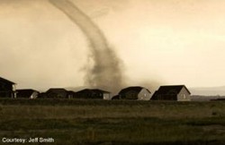
Photo of the tornado near Parker.  Image courtesy Jeff Smith and 9News.
Photo of the tornado near Parker. Image courtesy Jeff Smith and 9News.

Three tornadoes and multiple funnel clouds were reported in Elbert and Douglas counties Sunday evening.  At 5:31pm the Centennial Airport tower reported a tornado on the ground five miles southwest of Parker.  This was followed by a second tornado reported at 5:47pm six miles northeast of Parker.  Lastly, a third twister was spotted three miles west of Castle Rock reported by trained spotters at 6:03pm. 

News video showed the tornadoes weaving through relatively unpopulated areas interspersed wtih some houses.  Authorities currently report no major damage. 

Tornado warnings were issued but have now expired.  As always, please be aware of the weather situation around you and when a danger presents itself, take appropriate action. 

Update, 8/25/08, 7:50am – Reports are varying on the actual number of tornadoes that touched down.  We have seen reports as low as two twisters to as many as a dozen.  Chances are the actual number is toward the lower end of that range as oftentimes the same tornado is reported by multiple spotters with different descriptions of their locations.  The National Weather Service investigates these and at some point in the future will determine the true number of tornadoes.

Here is some video shot by a Parker resident:

Rare mountain tornado strikes Park County Saturday

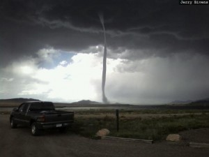
Park County tornado near Eleven Mile Reservoir.  Image courtesy 7News and Jerry Bivens.
Park County tornado near Eleven Mile Reservoir. Image courtesy 7News and Jerry Bivens.

In a truly unusual weather occurence, a tornado struck near Eleven Mile Reservoir in Park County Saturday afternoon.  Certainly we are all used to hearing about twisters along the Front Range and on the plains but mountain tornadoes are quite rare – the rugged terrain usually disrupts the weather patterns necessary to product tornadoes.  Authorities estimate five vehicles were damaged including a motorhome and pickup truck camper that were overturned, a trailer was destroyed.  Beyond cuts and scrapes, thankfully no one was injured. 

Colorado is ranked ninth in the country with an average of 40 tornadoes a year.  It is interesting to note that every state in the union – including Alaska and Hawaii – have had tornadoes. 

Doing some research at the TornadoProject.com yields an interesting fact as well.  This was Park County’s first tornado ever.  That leaves 12 of Colorado’s 64 counties that have never had a tornado including:

Clear Creek
Dolores
Garfield
Gilpin
Gunnison
Hinsdale
Lake
Montrose
Ouray
San Juan
San Miguel
Summit

It does serve as a reminder that while the unofficial severe weather season is behind us, Colorado’s weather is anything but boring and everyone should be aware of all the types of weather hazards that are possible.

Accepting the nomination outside – A weather risk or not?

Will Obama accept the nomination in rain or shine?
Will Barrack Obama accept the nomination in rain or shine?

The last time one of the major political parties held a major part of their political convention outdoors was 48 years ago.  On July 15, 1960 John F. Kennedy accepted his party’s nomination in the Los Angeles Coliseum before 50,000 people.  Denver isn’t Los Angeles though and our weather is a lot more volatile than sunny southern California.  As locals all know, the one thing consistent about Colorado weather is the inconsistency and that is true in the month of August.

As the end of the month comes, we start to notice our daylight hours getting fewer and even a bit of a chill in the early morning air. Historical temperature extremes for August are somewhat interesting. First, the highest temperature ever reached in Denver was actually recorded in August – 105 degrees on August 8, 1878 (also tied on July 20, 2005). Second, while there has never been snow in Denver in August, twice the mercury has dropped to 40 degrees to serve as a reminder the white stuff isn’t too far off – those occurrences were on August 22, 1904 and August 24, 1910.

On August 28th, the day Barrack Obama will accept the nomination, the normal high temperature is 83 degrees.  Extremes?  Our record high temperature for that day, set multiple times – most recently in 1969 – was 94 degrees.  The lowest high temperature ever recorded on the 28th is 66 degrees in 1898.

Generally the chance for severe storms decreases in August but precipitation is not unusual at all.  Cooler air near the surface helps to create a stable atmosphere thus keeping thunderstorms from usually becoming too intense. After the middle of August, tornadoes and damaging hail are pretty rare. The slow movement of storms this time of year are more likely to produce potentially heavy rain.

From midnight to noon convention visitors can usually expect clear conditions but it is the afternoon and evenings when things could get interesting.  Those are the times when thunderstorms roll across the Front Range – typically 8 days a month have them, 9 with measurable precipitation.

Will weather be a factor for the DNC in 2008?  We won’t know that until it gets closer but it could be interesting.

Signs of Fall approaching as cool and wet hit Thornton

Updated Saturday, 8/16/08 @ 5:19am – Denver officially reached a high temperature of 59 degrees on Friday (Thornton reached 58).  This crushed the old record low maximum temperature of 68 degrees set in 1880.  Saturday has the potential to do the same with a forecast high of 56.

Updated Friday, 8/15/08 @ 2:25pm – A Flood Watch has been issued by the National Weather Service effective immediately through Sunday morning.  As always, keep up to date with our real time advisories and our NOAA All Hazards Radio system.

—————-

From a record setting heatwave just a couple of weeks ago to cool and wet and possibly record setting temperatures at the other end of the spectrum too!  Colorado is nothing if not inconsistent!  🙂

A closed low has developed over much of Colorado and temperatures have dropped considerably and rain has fallen over much of the Front Range.  Rain showers and isolated thunderstorms will dominate the weather Friday as will cool temperatures.  Friday’s forecast high of 62 degrees is in fact 24 degrees below normal for this date.  If that forecast holds true, we could set a record for the lowest high temperature for the date as well – the previous record is 69 degrees set in 1933!  The same holds true for Saturday as well with a forecast high the same as Friday and the lowest high temperature on record of 68 degrees set way back in 1874. 

The rain brings much needed moisture to the Front Range but it will be slow in falling and shouldn’t pose much in the way of flooding problems.  As of this writing, the Rocky Mountain Weather Network is showing pretty consistent precipitation across the metro area with 0.29″ having fallen at ThorntonWeather.com so far.  The moisture will be on and off through Saturday night and then begin decreasing Sunday and into Monday. 

It looks like the first part of next week we will return to more seasonal weather and temperatures into the 80’s.

DNC Weather – Denver weather history for August 25 – 28

What can DNC visitors to Denver expect?

August is usually one of nicer weather months as summer winds down and temperatures cool.  The Democratic National Convention will be in Denver August 25th to August 28th and chances are the weather will be just fine.  A look back at historical weather events on those days though shows some interesting things have occurred in Denver weather history. 

Some of the highlights in Denver weather history include:

August 1875 saw grasshopper swarms in Denver.

August 25

In 1875 in the period from August 19th to the 20th grasshoppers appeared in great numbers in Denver.  Weather records say the “streets were literally covered with them” and swarms were seen on each day.  All gardens in the city were ruined as were many rural crops.  News stories say that on the 30th the grasshoppers were so numbers as to “almost darken the sun.”

In 1910, the lowest temperatures every recorded in August – 40 degrees – was recorded on August 24, 25 and 26. 

In 1951 a microburst produced a 50 mph gust of wind at Stapleton International Airport.  In 1964 thunderstorm winds gusted to 59 mph. 

More recently, in 1994, lightning struck a power pole in Louisville causing a two hour power outage.

August 26

The aforementioned grasshopper plague and low temperatures occurred on this date.

In 1944 one of the most destructive hail storms in the city caused nearly one million dollars in damage as it struck between 2:00 and 3:00pm.  Hail from very small to 1 ½ inches was reported and covered the ground to depths up to six inches in some areas.  Downtown Denver recorded 0.95 inch of rain and heavy hail.  News reports of the day report people being cut by broken glass, people being stranded by flooded cars, sewers backing up as they were unable to handle the deluge, buildings being flooded, trees stripped, telephone poles downed and more.  The next day the American Red Cross was designated by the War Department to grant any and all priorities needed to repair the damage. 

In 1961 two workmen suffered a broken foot and bruises when severe winds blew in the walls of a warehouse under construction. 

On the 26th and 27th in 1980, two thunderstorms hit Arvada and Westminster dumping 1.5 inches of rain in an hour.  Streets were washed out and homes and cars sustained damage.  Three homes in Arvada sustained damage from lightning.

August 27

The 1875 grasshopper invasion continued.

Lightning is always a danger in Colorado.

In 1967 a young woman that was horseback riding in west Denver was killed when she was struck by lightning; the horse died soon thereafter.  Another woman and young man riding with her were injured when they were thrown from their horses.  Lightning also did damage to houses in Arvada in 2003 and Parker in 2005.

1996 saw some excitement in the Fort Lupton area when 2 – 3 inches of rain fell in a 45 minute span.  A local college suffered damage when its roof leaked.  A weak F0 tornado was also reported in the area.

Not so long ago in 2002 large hail struck the metro area on this date.  Hail as large as 2 inches was reported in Jefferson County as well as 1.5 inches in Golden and Lakewood, 1 ¼ inches in Nederland, and 1 inch hail in Elizabeth, Louviers, Rollinsville and Blackhawk. 

2004 saw a cold spell hit the Denver area.  That year on the 27th the high temperature only reached 55 degrees setting a record low maximum for the date.  The low temperature of 48 tied the record low as well. 

August 28

Yes, the grasshopper swarm in 1875 continued.

The cold spell in 2004 yielded a low temperature on this date of 42 degrees setting a record.

1968, lightning again reared its ugly head.  One man was seriously injured while riding a roller coaster at Denver Amusement Park.  An airline employee was injured by lightning while working on a plane at Stapleton International Airport.  Also, lightning caused serious damage to a Denver house and minor damage to several others. 

Also on this date….  In 2002 a thunderstorm produced ¾ inch hail in Parker and in 2005 lightning sparked a small fire near Jamestown.

Various weather notes – the streak ends, big rain and more

Quite an eventful time we have had over the last 72 hours or so in terms of weather.  Some of the more noteworthy items:

The streak ends.  With cooler air finally moving into Colorado, Tuesday, August 5th marked the last day of our streak of 90 degree or higher temperatures.  Wednesday the temperature reached 88 degrees at DIA thus breaking the heat wave and ending the streak at a record 24 days.  The previous record of 18 days was last set 107 years ago in 1901!  Click here to view the official statistics for the streak.  Here at ThorntonWeather.com, our streak wasn’t quite as long.  While the official streak dates back to July 12th, Thornton did have one day – July 17th – where the temperature “only” reached 88 degrees.  If we start counting for Thornton on the 18th, that would put the Thornton streak at 17 days.  But, let’s face it, “hot is hot” no matter how you look at it! 

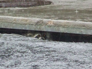
A racoon takes shelter in a storm drain at 120th & Colorado Blvd.  Image courtesy 9News.com.
A racoon takes shelter in a storm drain at 120th & Colorado Blvd. Image courtesy 9News.com.

Record seting rainstorm on Wednesday, August 6th.  As we discussed in our previous entry, severe weather moved across the Front Range bringing everything from thunder and lightning to funnel clouds and tornadoes to severe rain.  Various watches / warnings were issued including Tornado Warnings, Flash Flood Warnings / Watches and more.  Rain totals varied across the metro area with Thornton, particularly the northeast portions of the city, receiving the lion’s share.  At ThorntonWeather.com, we measured a whopping 2.43″.  The vast majority of that fell in a 70 minute time span from 6:00pm to 7:10pm.  Rain rates were reading between 3″ and 7″ per hour during that timeframe!  That is ThorntonWeather.com’s #1 rainiest day on record since going into service in October 2006; the previous record was 2.2″ set on April 24, 2007.  Some street flooding was reported in Thornton but thankfully little real damage.  At DIA they recorded 1.29″ of rain, breaking the old record for the date of 1.1″ set in 1929. 

Cooler weather to prevail today.  Significant moisture in the atmosphere and cooler temperatures should keep the excitement level down today – at least compared to yesterday.  After noon there will be a chance for rain and those that do get rain can expect it to be heavy at times.  As long as the temperatures stay down, we shouldn’t have the severity that we experienced yesterday though.  Click here to view the latest forecast.

Be safe, use your head, pay attention!  A bit of a report from the soapbox today.  As we were looking at pictures of the storm on various news sites, we came across one submitted to 9News from a Thornton resident of children playing in the street in the rain.  Now, that makes for a wonderfully fun picture and I am sure the kids had fun too but we do question how smart the parents were of these kids.  At the time Thornton was getting hit with the storm, lightning was popping across the entire area and there was a Tornado Warning issued as funnel clouds had been spotted.  Is outside playing in the street really where kids should be in a case like this?  That fun would come to a quick end if lightning struck or worse yet, one of those funnel clouds developed into a tornado.   Is that little bit of fun worth the risk of losing your child?  THINK ABOUT IT!  It may be worthwhile to review our Weather Education Series on Lightning and Tornadoes.

Thunderstorm brings funnel clouds, severe rain

An exciting evening in Thornton as far as the weather goes.  Just before 6:00pm Wednesday a slow-moving severe thunderstorm over north Thornton brought everything from funnel clouds to lightning to torrential rain. 

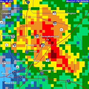
The Thornton radar image when the storm was at its height. The storm dumped over 2" of rain in 1 hour.
Rain began falling in the area of 120th and Colorado Blvd at 6:00pm and over the next 70 minutes dumped 2.36″ of precipitation.  Lightning and thunder were predominant for the entire time as well.  At 6:40 the National Weather Service issued a Tornado Warning when several funnel clouds were spotted between south Thornton and Dacono.  These slow moving storms presented a clear and present danger but appear to have passed relatively uneventful.  Minor street flooding has been reported in some parts of Thornton but otherwise little damage.

As of this writing, a Flood Advsiory and Flash Flood Watch remains in effect for much of the Denver metro area.  Radar does indicate the storm is deteriorating and things should beging to settle down now. 

As always, please stay tuned to ThorntonWeather.com for the latest.  Be sure to monitor our Warnings and Advsiories page for realtime updates on current watches and warnings.

The records keep coming & a new website feature

Denver’s record of consecutive days with 90+ degrees continues as Saturday reached 103 degrees officially at DIA.  Here in Thornton we topped out at 98.6.  The temperature was quickly climbing and we were sure we were going to break 100 but early afternoon brought cloud cover to the Thronton area thus keeping us from reaching triple digits.

From the National Weather Service, four records were broken in the first two days of the month:

  • August 1st:   New record high:  104 degrees   Old record:  100 degrees last set in 1938
  • August 2nd:  New record high:  103 degrees   Old record:  100 degrees last set 130 years ago in 1878
  • August 2nd:  New record high minimum:  70 degrees   Old record  68 degrees  last set in 1938
  • August 2nd:  the consecutive 90 streak record continues with 21 consecutive days tallied.

Quite the start to the month! 

New website feature added today!  You can now view official National Weather Service “Local Storm Reports” directly on our website.  These reports are submitted by NWS personnel, trained spotters, law enforcement as well as other emergency responders.  They are a great way to see what is happening.  This new feature not only displays these reports for the metro area but also for all NWS offices across the country!  Special thanks to Curly at Michiana Weather for sharing the code that allows this to happen.

You can view the storm reports at any time by a new menu item added under the “Live Condtions” menu and the “Forecast” menu on the left.