Category Archives: Climatology

NOAA Winter Outlook: Little clarity as to El Niño’s impact on Thornton

Temperature - U.S. Winter Outlook: 2015-2016.  Click for larger view. (NOAA)
Temperature – U.S. Winter Outlook: 2015-2016. Click for larger view. (NOAA)

NOAA’s Climate Prediction Center released their 2015-2016 winter outlook this morning and while a strong El Niño will play a factor in some parts of the nation, its effects here are less clear.

As we have written about before, Colorado’s geographical location well inland, shelters it some from the effects of warm, Pacific waters.   Overall snowfall in Colorado during El Niño years has not trended greatly one way or another.  We have however seen some of our largest storms during El Niño.

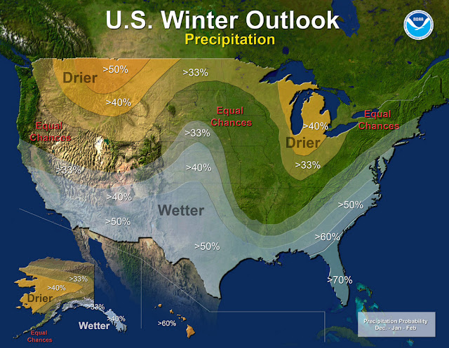
NOAA’s outlook shows a pretty typical El Niño situation with some locations of the nation expected to receive copious amounts of moisture.  For us, it does point to a bit better chance of a wetter than normal period from December to February.

Read the complete text of NOAA’s outlook below.  At the bottom is the video they released to accompany it.

From NOAA:

Precipitation - U.S. Winter Outlook: 2015-2016. Click for larger view. (NOAA)
Precipitation – U.S. Winter Outlook: 2015-2016. Click for larger view. (NOAA)

Forecasters at NOAA’s Climate Prediction Center issued the U.S. Winter Outlook today favoring cooler and wetter weather in Southern Tier states with above-average temperatures most likely in the West and across the Northern Tier. This year’s El Niño, among the strongest on record, is expected to influence weather and climate patterns this winter by impacting the position of the Pacific jet stream.

“A strong El Niño is in place and should exert a strong influence over our weather this winter,” said Mike Halpert, deputy director, NOAA’s Climate Prediction Center. “While temperature and precipitation impacts associated with El Niño are favored, El Niño is not the only player. Cold-air outbreaks and snow storms will likely occur at times this winter. However, the frequency, number and intensity of these events cannot be predicted on a seasonal timescale.”

Other factors that often play a role in the winter weather include the Arctic Oscillation, which influences the number of arctic air masses that penetrate into the South and nor’easters on the East Coast, and the Madden-Julian Oscillation, which can impact the number of heavy rain storms in the Pacific Northwest.

The 2015 U.S. Winter Outlook (December through February):

Precipitation Outlook:

  • Wetter-than-average conditions most likely in the Southern Tier of the United States, from central and southern California, across Texas, to Florida, and up the East Coast to southern New England. Above-average precipitation is also favored in southeastern Alaska.
  • Drier-than-average conditions most likely for Hawaii, central and western Alaska, parts of the Pacific Northwest and northern Rockies, and for areas near the Great Lakes and Ohio Valley.

Temperature Outlook:

  • Above-average temperatures are favored across much of the West and the northern half of the contiguous United States. Temperatures are also favored to be above-average in Alaska and much of Hawaii. Below-average temperatures are most likely in the southern Plains and Southeast.

Drought Outlook:

  • The U.S. Drought Outlook shows some improvement is likely in central and southern California by the end of January, but not drought removal. Additional statewide relief is possible during February and March. Drought removal is likely across large parts of the Southwest, while improvement or removal is also likely in the southern Plains. However, drought is likely to persist in the Pacific Northwest and northern Rockies, with drought development likely in Hawaii, parts of the northern Plains and in the northern Great Lakes region.

While it is good news that drought improvement is predicted for California, one season of above-average rain and snow is unlikely to remove four years of drought,” said Halpert. “California would need close to twice its normal rainfall to get out of drought and that’s unlikely.”

This seasonal outlook does not project where and when snowstorms may hit or provide total seasonal snowfall accumulations. Snow forecasts are dependent upon the strength and track of winter storms, which are generally not predictable more than a week in advance.

NOAA produces seasonal outlooks to help communities prepare for what’s likely to come in the next few months and minimize weather’s impacts on lives and livelihoods. Empowering people with actionable forecasts and winter weather tips is key to NOAA’s effort to build a Weather-Ready Nation.

NOAA’s mission is to understand and predict changes in the Earth’s environment, from the depths of the ocean to the surface of the sun, and to conserve and manage our coastal and marine resources. Join us on Facebook, Twitter, Instagram and our other social media channels.

El Niño Won’t Relieve West’s Drought, NOAA Predicts

Updated | Federal weather forecasters released their winter outlook Thursday, and it doesn’t look good for drought-stricken northern California, Oregon and Washington state. A strong El Niño this winter is predicted to intensify the Western drought through at least January, the National Oceanic and Atmospheric Administration announced. Earlier this week, NASA released a new image of… Continue reading El Niño Won’t Relieve West’s Drought, NOAA Predicts

Thornton’s October preview: Fall should finally make an appearance

Thornton, Colorado October weather preview.With the first full month of fall here, October usually brings one of the quietest weather months in the Denver area with plenty of mild, sunny days and clear, cool nights.

October is historically the second sunniest month and conditions are generally calm.

However we also will usually see our first taste of winter during the month with the first freeze and first snowfall of the season.  Temperatures as well will start to drop and by the end of the month the average nighttime lows are below freezing.

For complete details on our historical October weather and what we can expect in the coming month, read our complete October weather preview here.

  • Don’t miss a thing when it comes to our ever-changing weather! Be sure to ‘like’ us on Facebook, follow us on Twitter and add us to your Google+ circles.

September 2015 weather recap: One of the warmest, driest on record

With the mercury stuck stubbornly at the top of the scale and barely a few raindrops falling into the bucket, September 2015 will be going into the books as one of the warmest and driest on record.

High pressure dominated the entire region during the month.  This allowed temperatures to consistently climb above normal and helped prevent moisture from arriving in any significant amounts.  At Denver International Airport, 27 of the 30 days had above normal temperatures.  Thornton’s overall temperatures were cooler than DIA’s but we were still quite a bit warmer than average.

The monthly average temperature in Thornton came in at 67.1 degrees.  Out at the airport where the Mile High City’s official measurements are taken, the average was 69.4 degrees.

Denver’s historical average for September is 63.4 so both locations came in well above normal.  Officially, September 2015 ranks as the warmest September on record, easily jumping to the number one spot over September 1948 which had an average of 68.3 degrees.

Undoubtedly the big difference between measurements at DIA and other locations in the metro area are yet another example of the airport’s readings consistently being an outlier from the reality seen in more populated areas.  This has been an ongoing problem since the National Weather Service moved the official station from Stapleton.

The warmest mercury reading in Thornton during the month was 94 degrees on the 13th.  The coldest came on the 19th when temperatures dipped to 40 degrees in the early morning hours.  Eight days in Thornton topped out above the 90 degree mark.

At the airport, Denver’s warmest reading of 92 degrees came on September 2.  It’s coldest on September 19 (44 degrees).  The airport saw seven days with above 90 degree maximums.

Just as the month was exceedingly warm, it also was very dry.  Thornton saw a mere 0.09 inches fall in its rain bucket and Denver recorded 0.11 inches.  Both were far short of the September precipitation average of 0.96 inches.

DIA’s measurement means September 2015 goes into the books with the 9th least amount of precipitation in September since 1872 (16th driest overall).

Click here to view Thornton’s September 2015 climate report.

Thornton, Colorado's September 2015 temperature summary. (ThorntonWeather.com)
Thornton, Colorado’s September 2015 temperature summary. (ThorntonWeather.com)
Thornton, Colorado's September 2015 precipitation summary. (ThorntonWeather.com)
Thornton, Colorado’s September 2015 precipitation summary. (ThorntonWeather.com)

From the National Weather Service:

CLIMATE REPORT
NATIONAL WEATHER SERVICE BOULDER, CO
244 AM MDT THU OCT 1 2015

...THE DENVER CO CLIMATE SUMMARY FOR THE MONTH OF SEPTEMBER 2015... 

CLIMATE NORMAL PERIOD 1981 TO 2010
CLIMATE RECORD PERIOD 1872 TO 2015

WEATHER         OBSERVED          NORMAL  DEPART  LAST YEAR`S
                 VALUE   DATE(S)  VALUE   FROM    VALUE  DATE(S)
                                          NORMAL
................................................................ 
TEMPERATURE (F)
RECORD
 HIGH              97   09/06/2013
                        09/05/2013
                        09/04/1995
 LOW               17   09/29/1985
HIGHEST            92   09/02        91       1       94  09/03
LOWEST             44   09/19        35       9       33  09/12
AVG. MAXIMUM     85.2              78.5     6.7     78.9
AVG. MINIMUM     53.5              48.3     5.2     50.6
MEAN             69.4              63.4     6.0     64.8
DAYS MAX >= 90      7               3.4     3.6        2
DAYS MAX <= 32      0               0.0     0.0        0
DAYS MIN <= 32      0               0.8    -0.8        0
DAYS MIN <= 0 0 0.0 0.0 0 

PRECIPITATION (INCHES) 
RECORD
 MAXIMUM 5.61 2013
 MINIMUM T 1892 1944 
TOTALS 0.11 0.96 -0.85 1.79 
DAILY AVG. 0.00 0.03 -0.03 0.06 
DAYS >= .01         3               6.5    -3.5        9
DAYS >= .10         0               3.3    -3.3        4
DAYS >= .50         0               0.6    -0.6        1
DAYS >= 1.00        0               0.1    -0.1        1
GREATEST
 24 HR. TOTAL    0.12   08/31 TO 09/01           09/29 TO 09/29
                                                          09/28 TO 09/29
                                                          09/29 TO 09/29
 STORM TOTAL       MM                                 MM
 (MM/DD(HH))            MM                    09/29(00) TO 09/29(00)
                                                 09/29(00) TO 09/29(00)9
                                                 09/29(00) TO 09/29(00)9

SNOWFALL (INCHES)
RECORDS
 TOTAL             MM   MM
TOTALS            0.0               1.3

DEGREE_DAYS
HEATING TOTAL       9               125    -116       91
 SINCE 7/1         27               141    -114       98
COOLING TOTAL     148                76      72       88
 SINCE 1/1        861               764      97      701

FREEZE DATES
RECORD
 EARLIEST     09/08/1962
 LATEST       06/08/2007
EARLIEST                        10/07
LATEST                          05/05
.......................................................... 

WIND (MPH)
AVERAGE WIND SPEED              9.0
RESULTANT WIND SPEED/DIRECTION   2/195
HIGHEST WIND SPEED/DIRECTION    35/280    DATE  09/07
HIGHEST GUST SPEED/DIRECTION    54/270    DATE  09/07

SKY COVER
POSSIBLE SUNSHINE (PERCENT)   MM
AVERAGE SKY COVER           0.40
NUMBER OF DAYS FAIR           12
NUMBER OF DAYS PC             17
NUMBER OF DAYS CLOUDY          1

AVERAGE RH (PERCENT)     41

WEATHER CONDITIONS. NUMBER OF DAYS WITH
THUNDERSTORM              6     MIXED PRECIP               0
HEAVY RAIN                0     RAIN                       3
LIGHT RAIN                7     FREEZING RAIN              0
LT FREEZING RAIN          0     HAIL                       3
HEAVY SNOW                0     SNOW                       0
LIGHT SNOW                0     SLEET                      0
FOG                       3     FOG W/VIS <= 1/4 MILE      5
HAZE                      1

-  INDICATES NEGATIVE NUMBERS.
R  INDICATES RECORD WAS SET OR TIED.
MM INDICATES DATA IS MISSING.
T  INDICATES TRACE AMOUNT.

Fall Foliage 2015: Top spots to view the colors near the Front Range

The leaves in the high country are changing and certainly give meaning to the moniker 'Colorful Colorado.' (ThorntonWeather.com)
The leaves in the high country are changing and certainly give meaning to the moniker ‘Colorful Colorado.’ (ThorntonWeather.com)

This time of year many folks head to the hills west of Denver in search of gold – fall foliage gold.

This year the changing of the colors seems to be a bit spotty and an early freeze last fall followed by a late freeze this spring has impacted the overall quality of the show.  That certainly is not to say there isn’t some absolutely gorgeous spots out there.

Where to go?  Below are five of ThorntonWeather.com’s favorite ones near Denver – plus a few further out and some bonus ideas.  After that, we will tell you where you can find a great website that provides regular updates on viewing conditions.

I-70 Corridor – If you’re looking for the easiest route, then this one is for you.  Simply head west on I-70 about 110 miles to Avon.  Between Vail and Avon, both sides of I-70 are lined beautifully with aspen.

Rocky Mountain National Park – One of the most popular summer destinations in the state is of course also a prime spot to view aspen in all their glory.  Once in the park head toward Bear Lake.  Glacier Gorge Junction provides a beautiful spot and you of course also get to enjoy all the splendor that Rocky Mountain National Park has to offer.  Extend your viewing by taking Trail Ridge Road all the way through to the west side of the park and the Grand Lake and Granby area.

Peak to Peak Highway – This little road trip can be a dual purpose trip – gambling and fall foliage viewing!  Take U.S. 6 through Clear Creek Canyon and then 119 through Blackhawk and Central City.  You can of course stop there if your wallet is fat enough and donate some money to the casinos.  From there continue on 119 toward Nederland.  Take highway 72 toward Ward and Allenspark.  There you will find more golden aspen than you can imagine, all with the Continental Divide nearby.

Colorado Fall Foliage - Average Date of Peak Aspen Colors. Click for larger view. (ThorntonWeather.com)
Colorado Fall Foliage – Average Date of Peak Aspen Colors. Click for larger view. (ThorntonWeather.com)

Poudre Valley Canyon –  Heading north on I-25 take Colorado 14 west and into Poudre Canyon and Roosevelt National Forest.  As you continue west you will come very near timberline as you come to Cameron Pass.  Amazing views abound!

Guanella Pass – This is a nice, relatively short drive from Denver.  From C470 take 85 through Bailey and Conifer, a nice drive unto itself.  When you come to the town of Grant, take the Guanella Pass Scenic and Historic Byway north to Georgetown.  The air is pretty thin along the way as you climb in excess of 11,500 views through the Pike and Arapahoe National Forests.  Fair warning – about 10 miles of the road is gravel but it is well maintained.

A couple other possibilities further from the Front Range:

Leadville / Aspen – From Denver take I-70 west to Copper Mountain and then Colorado 91 south over Freemont Pass to Leadville. Along the way there are plenty of viewing opportunities and Leadville is a nice little town to make a stop. From here you can take Highway 24 north back through Minturn and Vail. To extend the drive, take Highway 24 south to Colorado 82 and head toward Aspen. You can stop by the Maroon Bells in White River National Forest to view some of the most photographed mountains in Colorado.

Cottonwood Pass – From Denver take Highway 285 to Buena Vista. Head west on Main Street for seven miles then west on County Road 344 / Colorado 82. From there you start the climb up Cottonwood Pass with absolutely stunning views from the top. If you are up for it, you can continue down the west side of the pass into the Taylor Park area. Be forewarned though that the western half of the pass is unpaved and twisty.

Honorable mentions worth considering:

  • Boreas Pass between Breckenridge and Como (County Road 10)
  • Kenosha Pass on Highway 285 between Bailey and Fairplay
  • Independence Pass (Colorado 82 between Aspen and Twin Lakes)
  • Colorado 103 from Evergreen to Echo Lake. Throw in a drive up Mount Evans for a bonus.

If you do head out, be sure to send us your pictures for inclusion in our monthly photo slideshows!

For more information:

August 2015 weather recap: Month saw near normal temps, below average precipitation

High pressure was the dominant feature across much of Colorado during the month of August 2015.  This helped keep temperatures quite warm and while there were occasional storms, they failed to deliver much in the way of precipitation.

We started out the month very warm and dry.  This was interrupted on the 9th when a series of disturbances finally brought some measurable precipitation.  Dry weather returned for a few days but then a strong cold front moved bring much cooler temperatures from the 17th to the 19th.  The break was short-lived and warmer mercury readings and drier conditions dominated the balance of the month.

Thornton’s average temperature for the month came in at 71.8 degrees, not far off Denver’s long term average for August of 72.5 degrees.  Out at DIA where the Mile High City’s official readings are taken, it was much warmer with an average of 74.0 degrees.

Temperatures in Thornton ranged from a high of 98.1 degrees on the 15th down to a low of 45.3 degrees on the morning of the 19th.  Denver’s maximum reading of 98 degrees came on the 15th as well and its lowest reading of 43 degrees came on the 23rd.

We saw 18 days with high temperature readings above the 90 degree mark. Denver saw one more than that.

Two daily high temperature records were tied in Denver during the month, those coming on the 18th and 26th with readings of 98 and 97 degrees respectively.  Additionally, two mornings in a row fell to record lows.  The record low temperature for the 18th (47 degrees) was tied and the following day a new record low of 47 degrees was set.

In terms of precipitation, a paltry 0.87 inches fell in Thornton’s rain bucket.  Out at the airport, Denver recorded 1.18 inches.  Both were well below Denver’s long term average of 1.69 inches for August.

Click here to view Thornton’s August 2015 climate report.

Thornton, Colorado's August 2015 temperatur?e summary. (ThorntonW?eather.com?)
Thornton, Colorado’s August 2015 temperatur?e summary. (ThorntonW?eather.com?)
Thornton, Colorado's August 2015 precipitat?ion summary. (ThorntonW?eather.com?)
Thornton, Colorado’s August 2015 precipitat?ion summary. (ThorntonW?eather.com?)

From the National Weather Service:

CLIMATE REPORT
NATIONAL WEATHER SERVICE BOULDER, CO
244 AM MDT TUE SEP 1 2015

................................... 

...THE DENVER CO CLIMATE SUMMARY FOR THE MONTH OF AUGUST 2015... 

CLIMATE NORMAL PERIOD 1981 TO 2010
CLIMATE RECORD PERIOD 1872 TO 2015

WEATHER         OBSERVED          NORMAL  DEPART  LAST YEAR`S
                 VALUE   DATE(S)  VALUE   FROM    VALUE  DATE(S)
                                          NORMAL
................................................................ 
TEMPERATURE (F)
RECORD
 HIGH             105   08/08/1878
 LOW               40   08/26/1910
                        08/25/1910
                        08/24/1910
HIGHEST            98   08/15       105      -7       91  08/19
                                                          08/17
LOWEST             43   08/23        40       3       52  08/31
                                                          08/30
                                                          08/25
AVG. MAXIMUM     89.8              87.2     2.6     83.8
AVG. MINIMUM     58.3              57.9     0.4     57.4
MEAN             74.0              72.5     1.5     70.6
DAYS MAX >= 90     19              11.5     7.5        4
DAYS MAX <= 32      0               0.0     0.0        0
DAYS MIN <= 32      0               0.0     0.0        0
DAYS MIN <= 0       0               0.0     0.0        0

PRECIPITATION (INCHES)
RECORD
 MAXIMUM         5.85   1979
 MINIMUM         0.02   1924
TOTALS           1.18              1.69   -0.51     2.73
DAILY AVG.       0.04              0.05   -0.01     0.09
DAYS >= .01         9               8.6     0.4       13
DAYS >= .10         4               4.3    -0.3        5
DAYS >= .50         1               1.2    -0.2        3
DAYS >= 1.00        0               0.3    -0.3        0
GREATEST
 24 HR. TOTAL    0.68   08/11 TO 08/11           08/25 TO 08/26
                        08/10 TO 08/11                    08/31 TO 08/31
                        08/11 TO 08/11                    08/31 TO 08/31
 STORM TOTAL       MM                                 MM
 (MM/DD(HH))            MM                    08/26(00) TO 08/26(00)
                                                 08/31(00) TO 08/31(00)1
                                                 08/31(00) TO 08/31(00)1

SNOWFALL (INCHES)
RECORDS
 TOTAL             MM   MM
TOTALS            0.0               0.0

DEGREE_DAYS
HEATING TOTAL      13                10       3        2
 SINCE 7/1         18                16       2        7
COOLING TOTAL     304               244      60      182
 SINCE 1/1        713               688      25      613

FREEZE DATES
RECORD
 EARLIEST     09/08/1962
 LATEST       06/08/2007
EARLIEST                        10/07
LATEST                          05/05
.................................................. 

WIND (MPH)
AVERAGE WIND SPEED              9.6
RESULTANT WIND SPEED/DIRECTION   3/189
HIGHEST WIND SPEED/DIRECTION    38/260    DATE  08/31
HIGHEST GUST SPEED/DIRECTION    47/340    DATE  08/09

SKY COVER
POSSIBLE SUNSHINE (PERCENT)   MM
AVERAGE SKY COVER           0.50
NUMBER OF DAYS FAIR            6
NUMBER OF DAYS PC             23
NUMBER OF DAYS CLOUDY          2

AVERAGE RH (PERCENT)     45

WEATHER CONDITIONS. NUMBER OF DAYS WITH
THUNDERSTORM             15     MIXED PRECIP               0
HEAVY RAIN                1     RAIN                       4
LIGHT RAIN               12     FREEZING RAIN              0
LT FREEZING RAIN          0     HAIL                       5
HEAVY SNOW                0     SNOW                       0
LIGHT SNOW                0     SLEET                      0
FOG                       4     FOG W/VIS <= 1/4 MILE      0
HAZE                      8

-  INDICATES NEGATIVE NUMBERS.
R  INDICATES RECORD WAS SET OR TIED.
MM INDICATES DATA IS MISSING.
T  INDICATES TRACE AMOUNT.

Denver sets second consecutive record low temperature

Record Cold TemperaturesFor the second day in a row, the Mile High City has set or tied a record low temperature.  The events certainly bring to mind the quickly approaching fall.

This morning, as measured at Denver International Airport, Denver’s temperature officially dropped to a low temperature of 47 degrees.  This bests the previous record low temperature for August 19 of 48 degrees last set in 2002.

Here in Thornton we actually were a bit cooler as we dipped to 45 degrees, our coldest reading since May 30.  This was also the coldest temperature on August 19 we have recorded in Thornton since ThorntonWeather.com came online in 2006.

Today’s record-setting temperature follows on yesterday’s record-tying low temperature of 47 degrees.  Additionally, highlighting the extremes we experience here in Colorado, it was just the previous Saturday that we tied the record high for the date (98 degrees).

  • Stay up to date with Thornton’s weather: Be sure to ‘like’ us on Facebook, follow us on Twitter and add us to your Google+ circles.

Denver ties record low temperature for August 18

Record Cold TemperaturesFrom record heat to record cold.  As measured at Denver International Airport, the temperature in the Mile High City dropped to 47 degrees at 5:17am.  This tied the record low temperature for the date last set in 1960.

It was just a few days ago that Denver tied a record high temperature on August 15.  Ironically, that record was previously hit in 1960 as well.

Here in Thornton we managed to stay a bit warmer with a low of 49.7 degrees.  This was our coldest temperature reading since May 31 (49.4 degrees).

  • Stay up to date with Thornton’s weather: Be sure to ‘like’ us on Facebook, follow us on Twitter and add us to your Google+ circles.

July 2015 weather recap: Cooler than normal temps, a bit drier than average

The month of July continued the recent trend of cool, damp weather.  By the time it was said and done though, while temperatures overall were below average, precipitation fell short of normal.

Temperatures were at or above normal for the first few days allowing for a pleasant Independence Day.

The day after, however, a monsoonal weather pattern cooled things down and brought most of the month’s moisture over the following 10 days.

Ridging then built and we settled into a relatively normal period for the final two weeks although precipitation became scarcer.

Thornton saw an average temperature for July 2015 of 71.2 degrees.  This was a good bit below the long term Denver average of 74.2 degrees.  Out at Denver International Airport where the Mile High City’s official measurements are taken, the average for the month was 72.8 degrees.

Our temperatures ranged from a high of 96.1 degrees on the 27th down to a low of 53 degrees on the 11th.  Denver saw a maximum of 97 degrees and a minimum of 52 degrees.

Denver averages 2.16 inches of precipitation during July.  Thornton fell a bit short of that mark recording 1.76 inches.  At the airport, only 1.06 inches was recorded.

Click here to view Thornton’s July 2015 climate report.

Thornton, Colorado July 2015 temperatur?e summary. (ThorntonW?eather.com?)
Thornton, Colorado July 2015 precipitat?ion summary. (ThorntonW?eather.com?)
CLIMATE REPORT
NATIONAL WEATHER SERVICE BOULDER, CO
202 PM MDT SAT AUG 1 2015

................................... 

...THE DENVER CO CLIMATE SUMMARY FOR THE MONTH OF JULY 2015... 

CLIMATE NORMAL PERIOD 1981 TO 2010
CLIMATE RECORD PERIOD 1872 TO 2015

WEATHER         OBSERVED          NORMAL  DEPART  LAST YEAR`S
                 VALUE   DATE(S)  VALUE   FROM    VALUE  DATE(S)
                                          NORMAL
................................................................ 
TEMPERATURE (F)
RECORD
 HIGH             105   07/20/2005
 LOW               42   07/04/1903
                        07/31/1873
HIGHEST            97   07/27                        100  07/07
LOWEST             52   07/28                         55  07/17
                                                          07/16
AVG. MAXIMUM     87.6              89.4    -1.8     88.3
AVG. MINIMUM     57.9              58.9    -1.0     60.6
MEAN             72.8              74.2    -1.4     74.5
DAYS MAX >= 90     16              16.0     0.0       17
DAYS MAX <= 32      0               0.0     0.0        0
DAYS MIN <= 32      0               0.0     0.0        0
DAYS MIN <= 0       0               0.0     0.0        0 
PRECIPITATION (INCHES) RECORD  
MAXIMUM         6.41   1965  
MINIMUM         0.01   1901 
TOTALS           1.06              2.16   -1.10     3.85 
DAILY AVG.       0.03              0.07   -0.04     0.12 
DAYS >= .01        12               8.3     3.7        8
DAYS >= .10         3               4.3    -1.3        6
DAYS >= .50         0               1.4    -1.4        2
DAYS >= 1.00        0               0.7    -0.7        2
GREATEST
 24 HR. TOTAL    0.33   07/18/15                    2.85  07/29/14
                        07/18/15                          07/30/14

SNOWFALL (INCHES)
 TOTAL            0.0                                0.0

DEGREE_DAYS
HEATING TOTAL       5                 6      -1        5
 SINCE 7/1          5                 6      -1        5
COOLING TOTAL     251               289     -38      304
 SINCE 1/1        409               444     -35      431

FREEZE DATES
RECORD
 EARLIEST     09/08/1962
 LATEST       06/08/2007
EARLIEST                        10/07
LATEST                          05/05
.................................................. 

WIND (MPH)
AVERAGE WIND SPEED              9.3
RESULTANT WIND SPEED/DIRECTION   3/176
HIGHEST WIND SPEED/DIRECTION    46/320    DATE  07/15
HIGHEST GUST SPEED/DIRECTION    60/330    DATE  07/15

SKY COVER
POSSIBLE SUNSHINE (PERCENT)   MM
AVERAGE SKY COVER           0.60
NUMBER OF DAYS FAIR            4
NUMBER OF DAYS PC             22
NUMBER OF DAYS CLOUDY          5

AVERAGE RH (PERCENT)     52

WEATHER CONDITIONS. NUMBER OF DAYS WITH
THUNDERSTORM              0     MIXED PRECIP               0
HEAVY RAIN                3     RAIN                       1
LIGHT RAIN               16     FREEZING RAIN              0
LT FREEZING RAIN          0     HAIL                       0
HEAVY SNOW                0     SNOW                       0
LIGHT SNOW                0     SLEET                      0
FOG                       7     FOG W/VIS <= 1/4 MILE      0
HAZE                      6

-  INDICATES NEGATIVE NUMBERS.
R  INDICATES RECORD WAS SET OR TIED.
MM INDICATES DATA IS MISSING.
T  INDICATES TRACE AMOUNT.

Thornton’s August weather preview: Cooler weather arrives

As summer vacations wind down and families prepare to send their kids back to school in August, Colorado weather also starts to settle down. The chances for severe weather decrease markedly during August and by the end of the month daytime temperatures are dropping quite a bit as well.

Find out more about what lies ahead with Thornton’s August weather here.