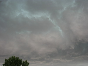
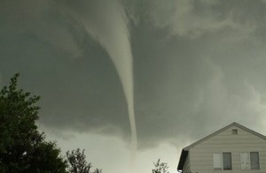
Ominous clouds tinged by green appeared over Thornton on Sunday. More images of the severe weather are posted below.
What had been a relatively quiet Sunday was shattered by severe storms moving across the Denver metro area and Thornton on Sunday. A deluge of rain coupled with hail and funnel clouds sent Thornton residents scrambling for cover and caused a rain delay for the Colorado Rockies when a funnel cloud was spotted near Coors Field. Hail up to 1 1/2 inches fell in parts of Thornton.
New photos added – Funnel cloud near Coors Field. See below.
A Tornado Warning was issued for a large swath of the metro area including Thornton. The warning has since expired but a Tornado Watch remains in effect for Thornton until 9:00pm Sunday evening so residents should remain aware.
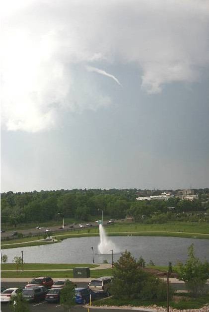
This funnel cloud was seen on Tuesday, June 9, from the Thornton Civic Center (looking north). Image courtesy Lisa Wilson, the City of Thornton.
MetroNorth Newspapers in the Northglenn-Thornton Sentinel covered the recent bout of severe weather in the most recent edition of Thornton’s hometown newspaper. In part, the article says:
As a former producer for 9News, Todd Barnes has chased a few tornadoes in his time. On Sunday, however, the storm found him.
Barnes, communications manager for the City of Thornton, was shopping at Costco in the Larkridge development near 162nd Avenue and Interstate 25 when he witnessed the funnel cloud form. The tornado touched down at 1:17 p.m. one mile north of Broomfield, near the northwestern edge of Thornton.
“There’s nothing like watching a tornado touch down,” Barnes said Monday. “It’s incredible.”
Another funnel cloud was spotted over the city at about 4:30 p.m. Tuesday. It appeared only briefly, high in the sky at a nearly 90-degree angle, before disappearing, according to witnesses. A tornado did touch down outside Firestone shortly after 5 p.m., but no serious damage was reported.
Do you subscribe to the Sentinel? Why not? There is no other source of truly local news available to Thornton and Northglenn residents and MetroNorth News and the Sentinel do an outstanding job of providing the depth of news and information area residents really need. If you haven’t read the Sentinel, pick up a copy and check it out. They do have a website but it isn’t particularly noteworthy and doesn’t have the same information you get in the print version. Subscriptions for the paper are very inexpensive and I would highly recommend it to everyone who lives in the area. Check it out and support Thornton’s hometown newspaper!
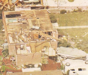
On June 3, 1981 a tornado struck Thornton in what is the worst twister to have struck the Denver metro area. Despite this, Thornton does not have any sort of emergency alert system to warn citizens of tornadoes or other civil disasters. Image courtesy the City of Thornton archives.
As we have discussed before, the City of Thornton is lacking any type of system to alert citizens of severe weather like we have seen recently. In the last week, parts of Thornton have been under Tornado Warnings as funnel clouds circled in the sky and citizens are understandably concerned.
We at ThorntonWeather.com continually remind people that the Denver metro area is at the far western edge of Tornado Alley and funnel clouds, tornadoes, hail and other types of severe weather are not unusual at all. It was 28 years ago last Wednesday in fact that the costliest tornado to ever hit the Denver metro area struck Thornton. Accounts vary but 53 people were injured, at least 25 homes were destroyed and hundreds more damaged.
The danger is real – tornadoes can and do strike in the Thornton area. In some ways it is surprising that the city did not implement some sort of system in the wake of the tornado in 1981. Many municipalities in the metro area do have warning sirens including Denver, Aurora, Englewood, Commerce City and Brighton.
Thornton Mayor Erik Hansen has told ThorntonWeather.com that the city will look at ways to inform citizens when severe weather is imminent. This may take the form of utilizing the reverse 911 system or as we suggested to him, a possible new text alert system that would deliver alerts to citizen’s mobile phones. It is our firm belief that some sort of system to be used not only for severe weather but for other civil disasters is a wise and prudent investment for the city to take.
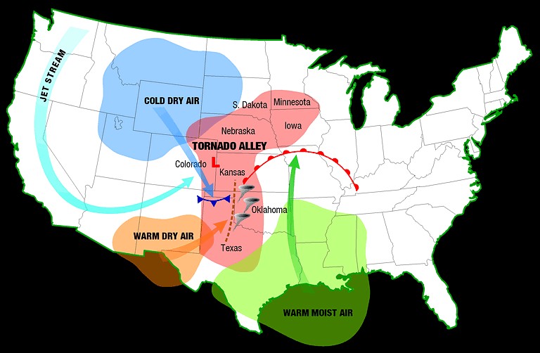
The Denver area is at the western edge of Tornado Alley and as we have seen historically and in recent days, the danger is real. Click image for larger view. Image courtesy NOAA.
This week the city posted some tornado safety tips on its website that are worth reviewing. You may also wish to review our Severe Weather 101 series which provides more in depth information on the entire array of spring and summer severe weather (links below).
We will continue our conversations with the city about how they can improve communication with Thornton residents about severe weather and keep you updated as appropriate. If you are so inclined, contact your city council representatives and let them know you want to see Thornton implement an emergency alert system.
This funnel cloud was seen on Tuesday from the Thornton Civic Center (looking north). Image courtesy the City of Thornton.
Severe weather has returned to the Denver metro area and the Front Range Tuesday afternoon. At approximately 4:50pm and for nearly one half hour afterwards trained spotters reported numerous funnel clouds over the Northglenn, Thornton, and Broomfield areas. No tornadoes touched down however.
Do you have pictures of the severe weather? Email them info@thorntonweather.com and we will post them.
At 5:11pm local law enforcement reported a tornado four miles northwest of Firestone moving at 20mph. This area remains under a Tornado Warning until 5:00pm.
If you are in an area under a Tornado Warning, do not try to outrun the storm or chase it in your vehicle. Immediately seek shelter in a building. If no structure is available, seek shelter in a ditch or low spot. If in your home or other building go to an interior hallway or ideally the basement.
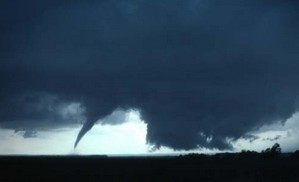
The tornado that struck Aurora, Colorado has been rated an EF1 with 100 mph winds by the National Weather Service. Image courtesy Sean Strachan. Follow the link below to go to Examiner.com for more images.
The tornado that touched down in the Denver suburb of Aurora and caused damage to a local mall and apartment complex has been rated an EF1 by the National Weather Service. After two days of evaluations, the service said that the twister most likely had winds of 100 mph, placing it in the middle of that rating.
The four other twisters that struck the area will be rated later this week. Because they were short lived and struck in open areas, they mostly likely will be rated as EF0 twisters with winds from 65 mph to 85 mph.
The other tornadoes were reported in the area of 144th and I-25, one was reported five miles south of Bennett, one five miles south of Deer Trail and one three miles north of Byers.
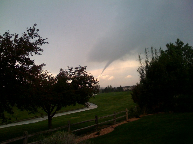
A funnel cloud near Thornton on Sunday, June 7, 2009. Image courtesy John Wagner, Warrior Legacy Foundation. View our slideshow below for more images.
For a brief period of time this afternoon, Thornton and western Adams County were under a Tornado Warning as a funnel cloud was spotted passing. Thankfully the storm quickly weakened and the threat diminished. The image at the right is courtesy John Wagner of the Warrior Legacy Foundation. This was from approximately 136th & Washington looking northwest.
View images from ThorntonWeather.com visitors in our slideshow below. Also check out two videos of the twister below!
Please stay aware of the latest severe weather in Thornton. As of this writing a Severe Thunderstorm Warning remains in effect and conditions could rapidly deteriorate again.
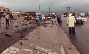
Damage along Washington was extensive from the tornado that struck Thornton on June 3, 1981. (City of Thornton archives)
It was 28 years ago today that the worst tornado to ever strike the Denver metro area hit Thornton. June 3, 1981 is a day that will forever be remembered by longtime residents of the north metro area.
Last year the Northglenn-Thornton Sentinel did a story about it which you can read by clicking here. Also, below is the entry from the National Weather Service’s history calendar – it is very interesting and serves as a good reminder that severe weather can strike anywhere.
In 1981…severe thunderstorms produced tornadoes over metro Denver. The first tornado touched down at the intersection of Alameda Ave. And Sheridan Blvd. The twister moved north along Sheridan Blvd….damaging businesses…apartment buildings…homes…and vehicles. Over ten homes were unroofed. The roof of one landed in the middle of a neighborhood park. At least 10 mobile homes were wrecked.
The tornado curved to the northeast into northwest Denver… Hopping up and down in several places. Very strong winds outside the actual funnel caused 20 to 30 thousand dollars in damage in downtown Denver. The third floor of one old building was demolished. No major injuries were reported from the tornado…although several people were hurt slightly in traffic accidents on Sheridan Blvd. in the confusion caused by the storm. Damage in Lakewood alone was estimated at 200 thousand dollars.
At the same time… The worst tornado to ever hit metro Denver struck Thornton. Coming from the same thunderstorm that spawned the Denver twister…the Thornton tornado tore a swath through the heart of the city. 87 homes were destroyed…110 others damaged at least moderately. In all…600 homes in a 100 block area sustained some damage. The twister also hit shopping centers…several restaurants…and other buildings. Seven of the 42 injured were considered serious. The storm was strong enough to snap lamp posts in half and drive a 6- inch slab of wood 2 feet into the ground. Damage was estimated at up to 50 million dollars.
The same storm that struck Thornton produced another damaging tornado that touched down in the northwest section of Fort Lupton. This twister damaged 16 homes and numerous cars and campers. Two children were slightly injured when the car they were in was knocked about and its windows shattered by the storm. The twister also damaged two commercial buildings. Damage was very spotty…and observers said the storm hopped up and down at least 3 times. Dollar damage was estimated at 500 thousand dollars.
The thunderstorm complex that produced 3 damaging tornadoes also dropped large hail which damaged many cars over northwest Denver. One to 2 inches of rain fell in less than an hour…flooding a mobile home park with 3 to 4 feet of water on the northwest edge of Denver. The high water damaged about half of the 392 homes in the park. Local flooding was also reported in other areas across metro Denver. A tornado was also sighted near Franktown…but caused no damage. A thunderstorm wind gust to 52 mph was recorded at Stapleton International Airport.
Air France Flight 447 is missing over the Atlantic this morning and presumed lost. (AP Photo)
An Air France jet en route from Rio de Janeiro to Paris carrying 228 people appears to have been lost over the Atlantic Ocean. The plane which disappeared approximately 190 miles northeast of the Brazilian city of Natal may have been brought down by severe weather the plane was flying through at the time it lost contact with air traffic controller.
Air France Flight 447 is reported to have hit strong turbulence and possibly lightning as the result of a thunderstorm. Air France says the plane, an Airbus A330, left Rio de Janeiro at 7:00pm local time and approximately four hours late the plan sent an automated signal indicating electrical problems. The airline said the plane “crossed through a thunderous zone with strong turbulence.” The automated message was received 14 minutes later at 0214GMT (10:14 pm EDT Sunday) “signaling electrical circuit malfunction.”
Francois Brousse, head of communications at Air France, “The plane might have been struck by lightning. It’s a possibility.”
Is global warming responsible for fewer tornadoes in 2009? Stu Ostro of the Weather Channel thinks so. Image courtesy NSSL.
Stormchasers across Tornado Alley have been frustrated this spring by what seems to be a lack of tornadoes and severe weather. Indeed, VORTEX2, the largest tornado field study ever, has been running for more than two weeks now and has not seen one twister. Last week, Weather Channel Senior Meteorologist Stu Ostro speculated that global warming was the cause.
In a segment with on-air meteorologist Stephanie Abrams, Ostro explained that the jet stream lingering over Canada and a continual ridge of high pressure were suppressing severe weather. Without the collision of low and high pressure (among other factors), tornadoes and supercell thunderstorms have a hard time forming.
Ostro continued his explanation saying that atmospheric pressure in the Northern Hemisphere’s mid-latitudes between 30 and 60 degrees has increased steadily since 1970. He then overlaid a chart showing this increase with that of a chart that shows global average temperatures having increased over the same period. As he says in his blog entry, “That parallels remarkably well the trend of globally-averaged temperatures, which has also shown a significant rise since the mid 1970s.”
Denver is historically Thornton's true severe weather month.
June is historically Denver’s severe weather month and severe thunderstorms, tornadoes and hail are notorious visitors to Denver and across eastern Colorado during the month. In fact, over 40 percent of the tornadoes that occur in Colorado are observed in June and these are typically the most destructive of the year. Severe thunderstorms have also caused major property damage across the Front Range during the month.
In just the last 25 years or so, there have been some particularly notable storms in June. Tornadoes have struck the metro area including one that longtime Thornton residents will recall on June 3, 1981. 53 residents were injured, 25 homes were destroyed and 239 other structures were damaged. Others tornadoes in the metro area include southeast Denver and Aurora on June 8, 1986 and east Denver on June 13, 1984. Severe thunderstorms occurring on June 13, 1984 dumped large hail making it one of the worst and the second costliest storm in Denver history. More recently, on June 20, 2001, a major hail storm moved across Denver International Airport dropping hailstones as big as two inches in diameter. Damage was extensive on and near the airport.