lkjhlkh
[shashin type=”albumphotos” id=”1″ size=”small” crop=”n” columns=”max” caption=”y” position=”center”]
lkjhlkh
[shashin type=”albumphotos” id=”1″ size=”small” crop=”n” columns=”max” caption=”y” position=”center”]

Overnight showers that lasted into the morning set a daily rainfall record in Denver. Even more notable, the rain added to the monthly total making this the wettest September ever recorded in the Mile High City.
As measured at Denver International Airport, Denver recorded 0.64 inches of rain today. This is a new daily record for September 23, beating the old record of 0.52 inches set in 2000.
Today’s rain, coupled with rainfall before midnight, brought Denver’s September monthly total to 5.47 inches. With that, September 2013 will go into the record books as the wettest September on record. The old monthly record was 4.67 inches set in 1961.
Denver’s rainfall total, while impressive, hardly compares to what has been seen in other locations. It also once again highlights how the station at DIA hardly represents the weather conditions seen in the metro area and makes historical comparisons somewhat invalid.
At the CO-OP station at Stapleton where Denver’s official weather measurements were taken from 1950 to 1995, the monthly total is at 9.08 inches. The difference in rainfall totals between the old location and DIA showcases how the station move to a different microclimate has skewed the Mile High City’s climate records.
Boulder, where some of the heaviest rains fell this month, was at 17.24 inches for the month before last night’s rain. Monthly rainfall totals in many locations across the Denver metro area are pushing the 10 inch mark.
There are of course still seven days left in the month and with showers in the forecast later this week, that record-setting total may increase.
Colorado’s September 2013 floods have been absolutely devastating with over 1,500 homes destroyed and a death toll yet to be finalized. NASA satellites flew over the area near Greeley in recent days and the before and after pictures provide a stunning view from above of the devastation.
Using the ‘sliders’ on the two image sets below you can compare how the area looks normally versus how it looked in the days immediately after the flooding.
[wpw_ba_viewer width=”600″ height=”auto” anim_speed=”600″ start_percent=”0.5″ disable_intro=”false”]
[wpw_ba_img src=”http://lh6.googleusercontent.com/-EHZnr2QxwDo/UjxBTiFTICI/AAAAAAAAArY/lN8SZl9OGLs/s600/greeley-before.jpg” data_second=”http://lh3.googleusercontent.com/-Afkp7QnthD8/UjxBTnDEMrI/AAAAAAAAArU/QsAh-2SWRkw/s600/greeley-after.jpg” title=”Satellite imagery comparison of the area near Greeley, Colorado before and after the September 2013 flooding. (NASA EO)” data_info=”Satellite imagery comparison of the area near Greeley, Colorado before and after the September 2013 flooding. (NASA EO)”]
[/wpw_ba_viewer]Satellite Imagery of Flooding Near Greeley, Colorado – “Though water levels on the South Platte River were receding, muddy brown waters were still out of the river’s banks near Greeley, Colorado, on September 17, 2013, when the Operational Land Imager (OLI) on the Landsat 8 satellite acquired this image. At the time, the river was more than six feet above flood stage, down from more than eight feet above flood stage.” The before image was acquired on June 29, 2013 and shows the area as it normally appears. (NASA EO)
[wpw_ba_viewer width=”600″ height=”auto” anim_speed=”600″ start_percent=”0.5″ disable_intro=”false”]
[wpw_ba_img src=”http://lh4.googleusercontent.com/-4P17RwE0yJ4/UjxBUXq6AEI/AAAAAAAAArc/jf6eRTTMaeQ/s600/platte-before.jpg” data_second=”http://lh6.googleusercontent.com/-oFx1h0x653Y/UjxBTgBj2KI/AAAAAAAAArM/-rgcmbR2otk/s600/platte-after.jpg” title=”Satellite imagery comparison of the area near Greeley, Colorado before and after the September 2013 flooding. (NASA EO)” data_info=”Satellite imagery comparison of the area near Greeley, Colorado before and after the September 2013 flooding. (NASA EO)”]
[/wpw_ba_viewer]Infrared Satellite Imagery of Flooded South Platte River – “Intense rainfall in northern and eastern Colorado brought widespread, destructive flooding in mid-September 2013. Local citizens reported as much as 18 inches (46 centimeters) of rain from September 9 to 15, with some of the heaviest accumulation along the Front Range of the Rocky Mountains. A break in the precipitation allowed the Moderate Resolution Imaging Spectroradiometer (MODIS) on NASA’s Aqua satellite to acquire the top image of the floods on September 14. The second image, taken by Terra MODIS on September 7, 2013, shows the region before the rains began. The images were made from infrared light to increase the contrast between water and land.” (NASA EO)
By the numbers, the rainfall experienced across northeastern Colorado since Monday, September 9 has been nothing short of extraordinary. Over the span of a week, many locations received half of what they normally receive in an entire year. Some received more than what they expect annually.
We have created and interactive map (below) that shows precipitation totals from Monday, September 9, 2013 to Monday, September 16, 2013. The numbers are totals as reported by CoCoRaHS volunteers – the Community Collaborative Rain, Hail & Snow Network.
Looking at the map, it is clear that the Boulder area received the most with one station recording an astonishing 21.13” over the 7 day timespan. The official station in Boulder has recorded 16.69” inches this month and 29.65” for the year. These numbers break Boulder’s monthly record and its annual precipitation record.
Denver’s official station at Denver International Airport (DIA) has recorded 4.65 inches this month, enough to put September 2013 in the books as the 2nd wettest on record. However, that total hardly reflects what locations closer to the city’s center received with many recording over 7” this month.
Here in Thornton we have seen 8.85” of rain so far this month, an extraordinary total that brings our total for 2013 to 18.81”. This is clearly the biggest month and year for precipitation since ThorntonWeather.com came online in 2007 and likely the biggest month ever in Thornton.
If you have a hard time viewing the map in the window below, click here to launch a larger version.
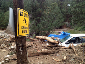
September 2013 will forever be etched in the memory of all Coloradans as one which brought amazing destruction – and death. Images of the truly historical event tell the story of the damage in the aftermath but also show the indomitable human spirit and the willingness of Americans to come together and help in times of need.
Northeastern Colorado has a surprisingly arid climate but also is an environment ripe for extreme weather events like the rain and floods we experienced.
The cost and final death toll from the floods will be determined in the coming days, weeks and months but we know already this is one for the record books.
The September 2013 event lasted multiple days and effects were felt from the mountains and foothills to the flat eastern plains. Many locations saw rainfall totals over four days equal to half of what they normally receive in an entire year.
The images in the slideshow below were gathered from a variety of sources. If you have photos to share, please email them to info@thorntonweather.com and we will add them.
| [flickr_set id=”72157697969563182″] |
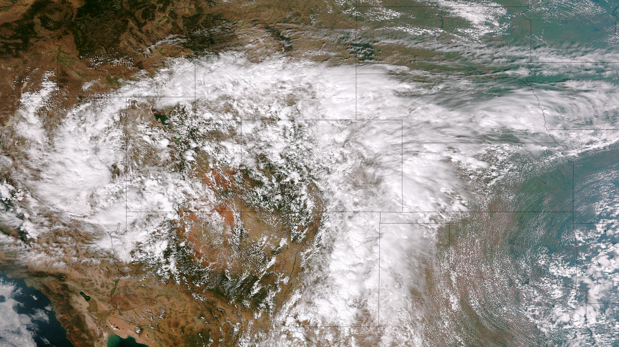
 The start of meteorological fall has been highly eventful with record-setting high temperatures followed by virtually unprecedented rainfall. Four days of steady, sometimes heavy, rain has created hazardous conditions in many places along the Colorado Front Range including Thornton.
We will be monitoring monitoring the storm very closely and posting regularly to our Facebook page and Twitter feed. You can follow along in real time below. We are also on Google+ here.
For comprehensive look at the storm, please monitor our Winter Weather Briefing page.
* Click the image above for a larger view
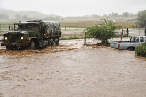
Five days of rain, one with absolutely torrential downpours, created dangerous and deadly flooding across much of the Colorado Front Range. At one point the National Weather Service warned of ‘biblical rainfall amounts’ and it became hard to argue with that terminology. The rainfall amounts were truly astounding.
Boulder, where some of the worst flooding was seen, recorded 9.08” on Thursday, September 12. Estes Park, where the Big Thompson River flooded its banks, saw 3.9” over the 24 hour period.
Officially Denver only saw 1.1” on the date but that was as measured at Denver International Airport which only saw the edge of the storms. At the previous historical location in Stapleton, 3.68” was measured.
Here in Thornton we seemed to be right in line for the storms and generated one of the higher totals in the metro area accumulating 4.76” on the date. Since the rain started five days ago, we have received an amazing 7.66” (as of this writing).
What has been called a 100-year storm and even referred to as being of ‘biblical’ proportions is very slowly coming to an end. The worst of the rain fell on Thursday, September 12 with locations in Colorado’s foothills reporting in excess of 8 inches of rainfall.
Among the hardest hit areas were the college town of Boulder and picturesque Estes Park. Both cities have seen extensive flooding and damage totals across the state will be well into the tens, if not hundreds, of millions of dollars.
The two videos below capture the raging waters as they pummeled the communities.
The first video shows Boulder as well as some commentary by Gov. John Hickenlooper. The second is of downtown Estes Park.

Twelve years ago today the United States of America was forever changed when war was brought to our own shores for the first time since Pearl Harbor. The imagery of that day still burns vividly in our memories and one from NASA shows the devastation of that day as seen from 200 miles above.
On that fateful day, crewmembers of the Expedition Three crew of the International Space Station were circling the globe.
Commander Frank L. Culbertson, Soyuz Commander Vladimir Dezhurov and Flight Engineer Mikhail Tyurin surely felt helpless as they passed over Ground Zero and could clearly see the plume of smoke emanating from the spot where so many people lost their lives.
The image they captured on that day was stunning – see below. While the World Trade Center was so far below, the devastation was so clear.
Our patriotism pulled us through those trying times and it shouldn’t take another attack to galvanize us in solidarity.
Today let us stand together to remember the victims of that horrible day.
Let us stand together and pay tribute to the lives of the thousands of men and women that have carried the battle forth since then and paid the ultimate sacrifice.
Let us stand together and honor the hundreds of thousands who wear our nation’s uniforms protecting us.
Let us never forget so that we and our children will never experience another day like 9/11.
NEVER FORGET!

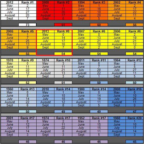
For the most part the Mile High City’s temperatures were on track to be pretty average this summer – up until the last half of August and first part of September. Since that time numerous high temperature records have been smashed and the number of days with temperatures over 90 degrees climbed.
As measured at Denver International Airport, Denver has officially recorded 54 days this year with high temperatures at or above 90 degrees. This puts 2013 into the books as tied for 6th place with 2006 and 2007 for the number of 90 degree days.
On average Denver sees 40 90 degree days a year with the last one falling, on average, on September 4th. The latest we have seen a 90 degree day was on October 1, 1892.
The grid below, from the National Weather Service, shows the top 20 years of 90+ degrees with the monthly distributions.
How has Thornton fared by comparison? As usual we were cooler than the airport having recorded 47 days with 90 degree or higher temperatures. Of those, we recorded none in May, 10 in June, 14 in July, 16 in August, and 7 in September.
Certainly it is possible we could see those numbers increase before the year is out. However long term trends are toward cooler and wetter weather so it is likely we are done for this year.