Severe weather is a common occurrence as we get further into spring and northeastern Colorado is set to experience multiple days of weather excitement. The first day’s activity skipped Thornton and stayed south but that is not expected to be the case Wednesday and Thursday.
Atmospheric conditions are primed for what may be a day of significant severe weather. Large, damaging hail, strong wind gusts, lightning and brief, heavy rain will all be likely. Some tornado activity will also be possible.
We will be monitoring monitoring the severe weather very closely and posting regularly to our Facebook page and Twitter feed. You can follow along in real time below. We are also on Google+ here.
Spring brings severe weather to the Great Plains and with those storms comes stormchasers. One group of chasers captured video and photos of a supercell’s amazing structure as it moved across northeastern Wyoming.
The video, taken by Basehunters, shows the motion of the swirling mass of a low precipitation supercell near Newcastle. Still imagery provides a dramatic view of the storm cell.
May 10, 2003 – Heavy, wet snow weighed down trees, damaging many. Click for a larger view. (ThorntonWeather.com)
With a significant spring storm set to impact our area tonight through tomorrow, a similar storm 10 years ago today provides a reminder of the potential for damage.
From May 9 to May 10, 2003, heavy, wet snow fell on the Denver area, much of it focused over northern suburbs like Thornton. Power lines were downed and trees took a beating.
Here in Thornton we received 7 inches as did Broomfield and DIA.
The National Weather Service ‘day in history’ noted:
“In 2003…a late spring snowstorm hammered the mountains… Eastern foothills…and urban corridor. The heaviest snowfall occurred north of Interstate 70. The heavy wet snow caused damage to trees throughout metro Denver and downed power lines. About 40 thousand people along the urban corridor were without power. Storm total snowfall amounts included: 11.5 inches in Louisville… 8 inches in Boulder and Broomfield; 7 inches in Thornton…Broomfield…at Denver International Airport… And at the site of the former Stapleton International Airport; and 6 inches 4 miles east of Denver. Snowfall ranged from 4 to 9 inches across extreme southern weld County. In the foothills…15 inches of snow fell near Jamestown…9 inches at Rollinsville and Rawah…with 8 inches at Chief Hosa and atop Lookout Mountain. The snow was accompanied by thunder on the afternoon of the 9th at Denver International Airport where west winds gusted to 25 mph on the 9th and north winds gusted to 22 mph on the 10th.”
The image to the right and the photos and video were taken in the ThorntonWeather.com backyard as the storm started to come to an end.
May 10, 2003 – Heavy, wet snow weighed down trees, damaging many. Click for a larger view. (ThorntonWeather.com)May 10, 2003 – Heavy, wet snow weighed down trees, damaging many. Click for a larger view. (ThorntonWeather.com)
Springtime brings severe weather to Colorado and it is appearing very likely much of that is in store today. While the best chances will be northeast of Thornton, the potential exists for damaging winds, large hail and possibly tornadoes.
We will be monitoring monitoring the storm very closely and posting regularly to our Facebook page and Twitter feed. You can follow along in real time below. We are also on Google+ here.
We went for a drive through Estes Park and into Rocky Mountain National Park yesterday. Always beautiful but now, a bit more dramatic for other reasons.
The devastation from last year’s floods are still very visible and while much has done rebuilding, much more needs to be done. Here you can see what is left of a car after being caught in the flood on Highway 34. In the background, the collapsed hillside is seen and two construction vehicles work to rebuild the riverbank.
Piles of debris and rubble as still visible as you climb up the canyon. While some houses have been rebuilt, others remain in pieces.
Remnants of Colorado’s September 2013 floods. (Tony’s Takes Photography)
Colorado’s famously highly variable weather seems to showcase itself during the month of May when a variety of weather conditions can be seen.
Winter-like temperatures and snow are possible as are mid-summer like temperatures or the more typical spring severe weather.
As the month starts out in 2014 we are going to enjoy a mild period with unseasonably warm temperatures and dry conditions. Long range forecasts predict a relatively ‘normal’ May.
However the month can bring extremes. Snow is not entirely uncommon during the month, oftentimes causing damage to newly bloomed trees. More common however is severe weather, particularly in the latter half of the month. Thunderstorms become more frequent and their associated hazards – lightning, wind, hail and tornadoes – are usual visitors.
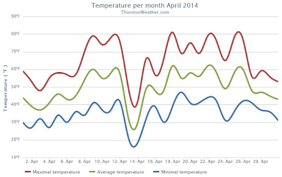
The month of April lacked much in the way of drama for northeastern Colorado. Overall temperatures were warmer than normal and precipitation and snow were lacking a bit.
April started out on the cool side and brought the first snow of the month on the 3rd. By the 8th temperatures had rebounded and we enjoyed a five-day stretch of high temps in the 70s.
A storm system and cold front cooled things down on the 13th and we saw a couple of days of light snowfall. As always the weather bounced back and Thornton recorded its first 80+ degree day of the year on the 18th.
The final four days of the month saw things turn cool again. Some light rain was seen but the bigger story was a period of unusually windy conditions.
Denver’s average April temperature is 47.4 degrees (1981 – 2010). For April 2014, the average temperature in Thornton was more than two degrees higher at 49.6 degrees. Out at Denver International Airport, the average came in a bit cooler at 49.0 degrees.
Temperatures in Thornton ranged from a high of 81.3 degrees on the 18th down to a low of 17.6 degrees on the 14th. DIA saw its warmest reading of 80 degrees on the 22nd and its coldest of 18 degrees on the 14th.
Low temperatures dropped below freezing on 11 days in Thornton. No readings below zero were recorded.
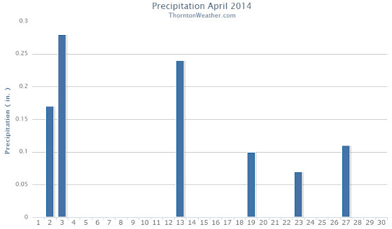
In terms of precipitation, Thornton measured 0.97 inch in the bucket. This is a good ways below the Denver April average of 1.71 inches. DIA saw more precipitation than us with a reading of 1.24 inches.
Similarly, snowfall fell short of normal in Thornton and Denver. On average the Mile High City sees 6.8 inches in April. Thornton recorded only 5.5 inches and DIA 5.6 inches.
April 2014 Temperature Summary for Thornton, Colorado. (ThorntonWeather.com)April 2014 Precipitation Summary for Thornton, Colorado. (ThorntonWeather.com)
CLIMATE REPORT
NATIONAL WEATHER SERVICE BOULDER, CO
603 AM MDT THU MAY 1 2014

...................................

...THE DENVER CO CLIMATE SUMMARY FOR THE MONTH OF APRIL 2014...

CLIMATE NORMAL PERIOD 1981 TO 2010
CLIMATE RECORD PERIOD 1872 TO 2014

WEATHER         OBSERVED          NORMAL  DEPART  LAST YEAR`S
                 VALUE   DATE(S)  VALUE   FROM    VALUE  DATE(S)
                                          NORMAL
................................................................
TEMPERATURE (F)
RECORD
 HIGH              90   04/30/1992
 LOW               -2   04/02/1975
HIGHEST            80   04/22        90     -10       80  04/29
LOWEST             18   04/14        -2      20        6  04/10
AVG. MAXIMUM     62.8              61.5     1.3     54.7
AVG. MINIMUM     35.2              33.3     1.9     28.7
MEAN             49.0              47.4     1.6     41.7
DAYS MAX >= 90      0               0.0     0.0        0
DAYS MAX <= 32      0               0.3    -0.3        4
DAYS MIN <= 32     10              13.0    -3.0       17
DAYS MIN <= 0       0               0.0     0.0        0
PRECIPITATION (INCHES)
RECORD
 MAXIMUM         8.24   1900
 MINIMUM         0.03   1963
TOTALS           1.24              1.71   -0.47     1.87
DAILY AVG.       0.04              0.06   -0.02     0.06
DAYS >= .01         6               9.1    -3.1       13
DAYS >= .10         5               4.5     0.5        7
DAYS >= .50         0               0.9    -0.9        0
DAYS >= 1.00        0               0.5    -0.5        0
GREATEST
 24 HR. TOTAL    0.48   04/02 TO 04/03              0.50
                                                04/22 TO 04/23
SNOWFALL (INCHES)
TOTAL             5.6               6.8

DEGREE_DAYS
HEATING TOTAL     472               529     -57      690
 SINCE 7/1       5730              5731      -1     5802
COOLING TOTAL       0                 1      -1        0
 SINCE 1/1          0                 1      -1        0

FREEZE DATES
RECORD
 EARLIEST     09/08/1962
 LATEST       06/08/2007
EARLIEST                        10/07
LATEST                          05/05
......................................................

WIND (MPH)
AVERAGE WIND SPEED              12.9
RESULTANT WIND SPEED/DIRECTION   2/299
HIGHEST WIND SPEED/DIRECTION    49/340    DATE  04/29
HIGHEST GUST SPEED/DIRECTION    66/340    DATE  04/29

SKY COVER
POSSIBLE SUNSHINE (PERCENT)   MM
AVERAGE SKY COVER           0.70
NUMBER OF DAYS FAIR            1
NUMBER OF DAYS PC             22
NUMBER OF DAYS CLOUDY          7

AVERAGE RH (PERCENT)     50

WEATHER CONDITIONS. NUMBER OF DAYS WITH
THUNDERSTORM              0     MIXED PRECIP               0
HEAVY RAIN                0     RAIN                       3
LIGHT RAIN                8     FREEZING RAIN              0
LT FREEZING RAIN          0     HAIL                       1
HEAVY SNOW                2     SNOW                       3
LIGHT SNOW                6     SLEET                      0
FOG                       8     FOG W/VIS <= 1/4 MILE      2
HAZE                      1

-  INDICATES NEGATIVE NUMBERS.
R  INDICATES RECORD WAS SET OR TIED.
MM INDICATES DATA IS MISSING.
T  INDICATES TRACE AMOUNT.
April 2014 started with blossoming trees. Scroll down for more photos from the month. (LW Inactivist)
April marks a transition between winter and summer for most of the country but for Denver it is especially true as we can see a stunning variety of weather.
The proverbial April showers are certainly a possibility for Denver. Snow? Tornadoes? Thunderstorms? You bet – all can happen!
That stunning variety will undoubtedly be showcased in our monthly photo slideshow (below).
Slideshow updated April 26, 2014
Showcasing images captured by ThorntonWeather.com readers as well as some of our own, our monthly slideshow covers the entire gamut of weather-related imagery. Sunsets, sunrises, wildlife and of course snow are vividly depicted.
Throughout the month we will gather the images sent to us via email or shared with us via our various social media outlets and post them in the slideshow below.
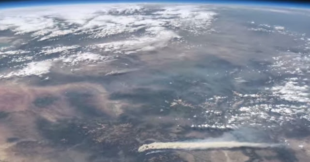
A scene from a new NASA video shows Colorado’s West Fork Fire in June 2013 among other area weather and climate events. (NASA / YouTube)
A stunning video released by NASA this week provides a bird’s eye view of some of the Earth’s most significant weather and climate events of last year.
Using images and movies from satellites and the International Space Station, scenes from across the globe are shown in the video titled “Earth from Orbit 2013.”
Colorado and surrounding states however will draw the most attention from many locally.
From their perch high above, imagery of Colorado’s West Fork Fire in June 2013 is seen as well as the effects of the September floods.
To our south, the drought in New Mexico is seen having taken its toll on Elephant Butte Reservoir in New Mexico. The veritable explosion of storm cells that lea to devastation in Oklahoma during a May tornado outbreak are also shown.
Below the video you will find a description of each scene and links to more imagery.
From NASA – Published on Apr 21, 2014:
A fleet of orbiting satellites monitors Earth constantly. The satellites from NASA and other space agencies give us a fresh, wide perspective on things that we can see from the ground — and things that we can’t.
A look back at Earth in 2013 from the viewpoint of orbit reveals the kind of data gathering and technical achievement that are the reason NASA puts Earth-observing satellites in space. A visualization of satellite and computer model data shows how a cloud of dust from the Chelyabinsk meteor moved around the world. NASA satellites measured the intensity of wildfires, the salinity of the oceans and rainfall around the globe — whether it was too little or too much.
To learn more about NASA’s Earth science in 2014, please visit: www.nasa.gov/earthrightnow
 Severe weather is a common occurrence as we get further into spring and northeastern Colorado is set to experience multiple days of weather excitement. The first day’s activity skipped Thornton and stayed south but that is not expected to be the case Wednesday and Thursday.