
|
New Delhi (dpa) – More than 100 people have been killed, most of them in India’s eastern states, during heavy rains and floods over the past week, officials said Monday. More than 4 million people in 10,000 villages were affected in the states of West Bengal, Orissa and Manipur after cyclone Komen struck the region on… Continue reading Over 100 dead in India floods |
All posts by Thornton Weather
July 2015 weather recap: Cooler than normal temps, a bit drier than average
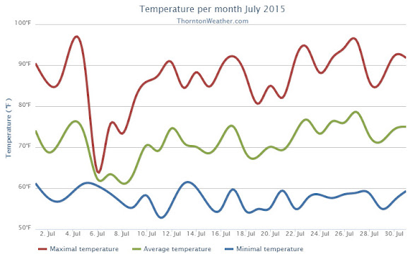
The month of July continued the recent trend of cool, damp weather. By the time it was said and done though, while temperatures overall were below average, precipitation fell short of normal.
Temperatures were at or above normal for the first few days allowing for a pleasant Independence Day.
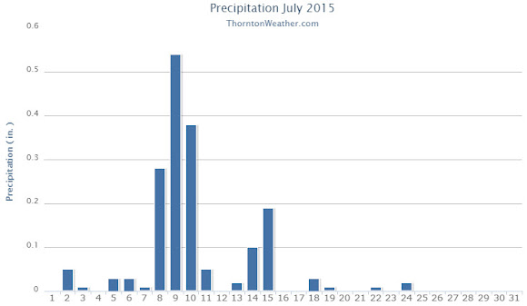
The day after, however, a monsoonal weather pattern cooled things down and brought most of the month’s moisture over the following 10 days.
Ridging then built and we settled into a relatively normal period for the final two weeks although precipitation became scarcer.
Thornton saw an average temperature for July 2015 of 71.2 degrees. This was a good bit below the long term Denver average of 74.2 degrees. Out at Denver International Airport where the Mile High City’s official measurements are taken, the average for the month was 72.8 degrees.
Our temperatures ranged from a high of 96.1 degrees on the 27th down to a low of 53 degrees on the 11th. Denver saw a maximum of 97 degrees and a minimum of 52 degrees.
Denver averages 2.16 inches of precipitation during July. Thornton fell a bit short of that mark recording 1.76 inches. At the airport, only 1.06 inches was recorded.
Click here to view Thornton’s July 2015 climate report.
CLIMATE REPORT
NATIONAL WEATHER SERVICE BOULDER, CO
202 PM MDT SAT AUG 1 2015

...................................

...THE DENVER CO CLIMATE SUMMARY FOR THE MONTH OF JULY 2015...

CLIMATE NORMAL PERIOD 1981 TO 2010
CLIMATE RECORD PERIOD 1872 TO 2015

WEATHER         OBSERVED          NORMAL  DEPART  LAST YEAR`S
                 VALUE   DATE(S)  VALUE   FROM    VALUE  DATE(S)
                                          NORMAL
................................................................
TEMPERATURE (F)
RECORD
 HIGH             105   07/20/2005
 LOW               42   07/04/1903
                        07/31/1873
HIGHEST            97   07/27                        100  07/07
LOWEST             52   07/28                         55  07/17
                                                          07/16
AVG. MAXIMUM     87.6              89.4    -1.8     88.3
AVG. MINIMUM     57.9              58.9    -1.0     60.6
MEAN             72.8              74.2    -1.4     74.5
DAYS MAX >= 90     16              16.0     0.0       17
DAYS MAX <= 32      0               0.0     0.0        0
DAYS MIN <= 32      0               0.0     0.0        0
DAYS MIN <= 0       0               0.0     0.0        0
PRECIPITATION (INCHES) RECORD
MAXIMUM         6.41   1965
MINIMUM         0.01   1901
TOTALS           1.06              2.16   -1.10     3.85
DAILY AVG.       0.03              0.07   -0.04     0.12
DAYS >= .01        12               8.3     3.7        8
DAYS >= .10         3               4.3    -1.3        6
DAYS >= .50         0               1.4    -1.4        2
DAYS >= 1.00        0               0.7    -0.7        2
GREATEST
 24 HR. TOTAL    0.33   07/18/15                    2.85  07/29/14
                        07/18/15                          07/30/14

SNOWFALL (INCHES)
 TOTAL            0.0                                0.0

DEGREE_DAYS
HEATING TOTAL       5                 6      -1        5
 SINCE 7/1          5                 6      -1        5
COOLING TOTAL     251               289     -38      304
 SINCE 1/1        409               444     -35      431

FREEZE DATES
RECORD
 EARLIEST     09/08/1962
 LATEST       06/08/2007
EARLIEST                        10/07
LATEST                          05/05
..................................................

WIND (MPH)
AVERAGE WIND SPEED              9.3
RESULTANT WIND SPEED/DIRECTION   3/176
HIGHEST WIND SPEED/DIRECTION    46/320    DATE  07/15
HIGHEST GUST SPEED/DIRECTION    60/330    DATE  07/15

SKY COVER
POSSIBLE SUNSHINE (PERCENT)   MM
AVERAGE SKY COVER           0.60
NUMBER OF DAYS FAIR            4
NUMBER OF DAYS PC             22
NUMBER OF DAYS CLOUDY          5

AVERAGE RH (PERCENT)     52

WEATHER CONDITIONS. NUMBER OF DAYS WITH
THUNDERSTORM              0     MIXED PRECIP               0
HEAVY RAIN                3     RAIN                       1
LIGHT RAIN               16     FREEZING RAIN              0
LT FREEZING RAIN          0     HAIL                       0
HEAVY SNOW                0     SNOW                       0
LIGHT SNOW                0     SLEET                      0
FOG                       7     FOG W/VIS <= 1/4 MILE      0
HAZE                      6

-  INDICATES NEGATIVE NUMBERS.
R  INDICATES RECORD WAS SET OR TIED.
MM INDICATES DATA IS MISSING.
T  INDICATES TRACE AMOUNT.
Thornton’s August weather preview: Cooler weather arrives
As summer vacations wind down and families prepare to send their kids back to school in August, Colorado weather also starts to settle down. The chances for severe weather decrease markedly during August and by the end of the month daytime temperatures are dropping quite a bit as well.
Find out more about what lies ahead with Thornton’s August weather here.

July 2015 top shots: Monthly photo slideshow

Colorado offers outdoor opportunities unlike any other state and while the summer heat settles in, photos of the amazing scenes across our state provide a view into why we love it here so much.
The weather this time of year has a pretty standard pattern of quickly warming temperatures followed by afternoon thunderstorms that can cool things down. These storms sometimes provide a good bit of ‘excitement’ and are a prime photo subject.
- Slideshow updated July 31, 2015
Recreationalists head outdoors and take advantage of urban, suburban and rural opportunities. As they do, our abundant wildlife that is found just about anywhere comes into focus.
Showcasing images captured by ThorntonWeather.com readers as well as some of our own, our monthly slideshow covers the entire gamut of weather and nature related imagery. Sunsets, sunrises, wildlife and of course every type of weather condition are vividly depicted.
To learn more about how to send your photo to us for inclusion in the slideshow, see below the slideshow.
| [flickr_set id=”72157656079164135″] |
What is missing in the slideshow above? Your photo!
Our monthly photo slideshow is going to feature images that we have taken but more importantly images that you have captured. The photos can be of anything even remotely weather-related.
Landscapes, current conditions, wildlife, pets, kids. Whimsical, newsy, artsy. Taken at the zoo, some other area attraction, a local park, a national park or your backyard. You name it, we want to see and share it!
Images can be taken in Thornton, Denver or anywhere across the extraordinary Centennial State. We’ll even take some from out of state if we can tie it to Colorado somehow.
We’ll keep the criteria very open to interpretation with just about any image eligible to be shown in our slideshows.
What do you win for having your image in our slideshow? We are just a ‘mom and pop’ outfit and make no money from our site so we really don’t have the means to provide prizes. However you will have our undying gratitude and the satisfaction that your images are shared on the most popular website in Thornton.
To share you images with us and get them included in the slideshow just email them to us or share them with ThorntonWeather.com on any of the various social media outlets. Links are provided below.
So come on, get those camera’s rolling!
- Email: info@ThorntonWeather.com
- Facebook: https://www.facebook.com/ThorntonWeather
- Google+: https://plus.google.com/+Thorntonweather
- Twitter: @ThorntonWeather (https://twitter.com/thorntonweather)
Climate change ‘urgent and growing threat’ to national security: Pentagon
|
A new Pentagon report says that climate change is an “urgent and growing threat to our national security” and blames it for “increased natural disasters” that will require more American troops designated to combat bad weather. Some studies have questioned whether such a trend exists. Says the Pentagon report released Wednesday, “Global climate change will have… Continue reading Climate change ‘urgent and growing threat’ to national security: Pentagon |
Freakishly High Temperatures Trigger Tajikistan Floods
|
Mudflows and flooding triggered by an ice melt in the central Asian country of Tajikistan have displaced more than 600 people, according to the International Organization for Migration (IOM). Usually high summer temperatures in Tajikistan, home to 8.4 million people, caused a glacial melt on July 16. The resulting water runoff hit the Shughnon district in… Continue reading Freakishly High Temperatures Trigger Tajikistan Floods |
2005’s Hurricane Katrina led to improvement in storm forecasting
|
FORT LAUDERDALE, Fla. — Hurricane Katrina, the most-destructive and third-deadliest storm in U.S. history, also was a force for change, spurring major advancements in forecasting and communication. Since its rampage in late August 2005, scientists have developed several new high-tech tools to better predict the strength and track of storms, in hopes of preventing a similar… Continue reading 2005’s Hurricane Katrina led to improvement in storm forecasting |
June 2015 weather recap: Warmer and wetter than normal conditions for the month
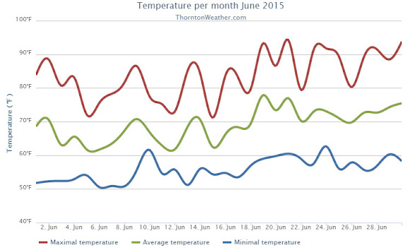
The month of June was a rather eventful one with wetter than normal conditions starting things out and temperatures coming in quite a ways above normal. Further, the month lived up to its reputation as Colorado’s severe weather month with numerous notable thunderstorms and a good bit of tornado activity.
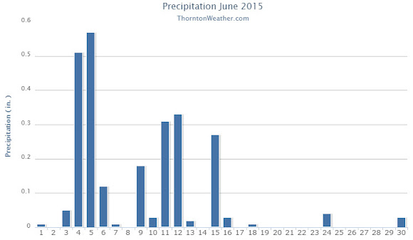
The month started out warm and dry but on the 3rd a cold front moved in cooling things down and bringing healthy shots of rain. On the 4th and 5th Thornton saw more than a half inch of rain on each day.
To our north, the 4th brought extreme weather in the form of an EF-3 tornado near Berthoud and multiple, smaller tornadoes in the Simla area to the southwest.
We then dried out a bit and warmed up but on the 9th another cold front arrived. Like the previous system, cooler temperatures and a decent shot of rain followed.
In the first 18 days of the month, Thornton saw 14 days with measurable precipitation. That however chanced for the latter third of the month as we dried out and warmed up significantly. There were still days with thunderstorms but the bulk of them seemed to just miss Thornton for the most part.
Such was the case of the 24th when extreme weather hit to our south. While we saw just a bit of rain, other areas near central Denver recorded far more and an EF-1 tornado struck from northeast Denver to northwest Aurora.
Overall Thornton’s monthly average temperature for June 2015 came in at 69.0 degrees. This was a good ways above the long term June average for Denver of 67.4 degrees. Out at the airport, the Mile High City’s official average reading was 69.5 degrees.
Temperatures in Thornton ranged from a high of 94.3 degrees on the 21st down to a low of 50.5 degrees on the morning of the 6th. Denver’s highest reading of 94 degrees came on the 30th and its lowest of 51 degrees on the 3rd.
In terms of precipitation, both Thornton and Denver recorded identical amounts in their rain buckets. The 2.53 inches of precip bested Denver’s June average of 1.98 inches by a good bit. In all, Thornton saw 16 days of measurable precipitation while Denver recorded 13.
Click here to view Thornton’s June 2015 climate report.
CLIMATE REPORT
NATIONAL WEATHER SERVICE BOULDER, CO
806 PM MDT SAT JUL 4 2015

...................................

...THE DENVER CO CLIMATE SUMMARY FOR THE MONTH OF JUNE 2015...

CLIMATE NORMAL PERIOD 1981 TO 2010
CLIMATE RECORD PERIOD 1872 TO 2015

WEATHER         OBSERVED          NORMAL  DEPART  LAST YEAR`S
                 VALUE   DATE(S)  VALUE   FROM    VALUE  DATE(S)
                                          NORMAL
................................................................
TEMPERATURE (F)
RECORD
 HIGH             105   06/26/2012
                        06/25/2012
                        54/01/2206
 LOW               30   06/02/1951
HIGHEST            94   06/30                         94  06/26
LOWEST             51   06/03                         42  06/15
AVG. MAXIMUM     82.9              82.4     0.5     83.4
AVG. MINIMUM     56.1              52.3     3.8     51.2
MEAN             69.5              67.4     2.1     67.3
DAYS MAX >= 90      6               7.9    -1.9        6
DAYS MAX <= 32      0               0.0     0.0        0
DAYS MIN <= 32      0               0.0     0.0        0
DAYS MIN <= 0       0               0.0     0.0        0

PRECIPITATION (INCHES)
RECORD
 MAXIMUM         4.96   1882
 MINIMUM            T   1890
TOTALS           2.53              1.98    0.55     1.82
DAILY AVG.       0.08              0.07    0.01     0.06
DAYS >= .01        13               8.4     4.6        9
DAYS >= .10         5               4.6     0.4        5
DAYS >= .50         2               1.4     0.6        1
DAYS >= 1.00        0               0.3    -0.3        0
GREATEST
 24 HR. TOTAL    0.99   06/05 TO 06/05           06/27 TO 06/27

SNOWFALL (INCHES)
RECORDS
 TOTAL            0.0
TOTALS            0.0               0.0

DEGREE_DAYS
HEATING TOTAL      11                62     -51       30
 SINCE 7/1       5583              6058    -475     6004
COOLING TOTAL     154               133      21      106
 SINCE 1/1        158               155       3      127

FREEZE DATES
RECORD
 EARLIEST     09/08/1962
 LATEST       06/08/2007
EARLIEST                        10/07
LATEST                          05/05
........................................................

WIND (MPH)
AVERAGE WIND SPEED              9.0
RESULTANT WIND SPEED/DIRECTION   2/167
HIGHEST WIND SPEED/DIRECTION    36/160    DATE  06/24
HIGHEST GUST SPEED/DIRECTION    47/160    DATE  06/24

SKY COVER
POSSIBLE SUNSHINE (PERCENT)   MM
AVERAGE SKY COVER           0.50
NUMBER OF DAYS FAIR            6
NUMBER OF DAYS PC             22
NUMBER OF DAYS CLOUDY          2

AVERAGE RH (PERCENT)     61

WEATHER CONDITIONS. NUMBER OF DAYS WITH
THUNDERSTORM             16     MIXED PRECIP               0
HEAVY RAIN                4     RAIN                       5
LIGHT RAIN               16     FREEZING RAIN              0
LT FREEZING RAIN          0     HAIL                       3
HEAVY SNOW                0     SNOW                       0
LIGHT SNOW                0     SLEET                      1
FOG                       6     FOG W/VIS <= 1/4 MILE      1
HAZE                      3

-  INDICATES NEGATIVE NUMBERS.
R  INDICATES RECORD WAS SET OR TIED.
MM INDICATES DATA IS MISSING.
T  INDICATES TRACE AMOUNT.
June 2015 top shots: Monthly photo slideshow

The month of June typically sees springtime severe weather reach its height of activity in northeastern Colorado.
This affords the opportunity to capture extraordinary images of amazing weather phenomena from monstrous supercell thunderstorms to heavy rain, hail and even tornadoes.
- Slideshow updated July 1, 2015
Showcasing images captured by ThorntonWeather.com readers as well as some of our own, our monthly slideshow covers the entire gamut of weather and nature related imagery.
Sunsets, sunrises, wildlife and of course every type of weather condition are vividly depicted. June brings some very dynamic weather and the photos are a great way to see the stunning variety.
To learn more about how to send your photo to us for inclusion in the slideshow, see below the slideshow.
| [flickr_set id=”72157654137987799″] |
What is missing in the slideshow above? Your photo!
Our monthly photo slideshow is going to feature images that we have taken but more importantly images that you have captured. The photos can be of anything even remotely weather-related.
Landscapes, current conditions, wildlife, pets, kids. Whimsical, newsy, artsy. Taken at the zoo, some other area attraction, a local park, a national park or your backyard. You name it, we want to see and share it!
Images can be taken in Thornton, Denver or anywhere across the extraordinary Centennial State. We’ll even take some from out of state if we can tie it to Colorado somehow.
We’ll keep the criteria very open to interpretation with just about any image eligible to be shown in our slideshows.
What do you win for having your image in our slideshow? We are just a ‘mom and pop’ outfit and make no money from our site so we really don’t have the means to provide prizes. However you will have our undying gratitude and the satisfaction that your images are shared on the most popular website in Thornton.
To share you images with us and get them included in the slideshow just email them to us or share them with ThorntonWeather.com on any of the various social media outlets. Links are provided below.
So come on, get those camera’s rolling!
- Email: info@ThorntonWeather.com
- Facebook: https://www.facebook.com/ThorntonWeather
- Google+: https://plus.google.com/+Thorntonweather
- Twitter: @ThorntonWeather (https://twitter.com/thorntonweather)
Aurora, Colorado tornado rated EF-1
 The National Weather Service completed an assessment of the damage caused during yesterday’s severe weather in the Denver metro area. They determined that a tornado did indeed touch down and was responsible for the bulk of the damage in Aurora.
The service said the twister was on the ground for 2.8 miles as it passed through Aurora. It however was not a wide tornado only reaching a maximum of 50 yards. Maximum winds were estimated at 86 to 90 mph giving it an EF-1 rating.
The complete text from the National Weather Service statement follows:
NOUS45 KBOU 251829 CCA
PNSBOU
COZ030>051-260600-

PUBLIC INFORMATION STATEMENT...CORRECTED ENDING TIME
NATIONAL WEATHER SERVICE DENVER, CO
1148 AM MDT THU JUN 25 2015

...NWS DAMAGE SURVEY FOR 06/24/2015 TORNADO EVENT...

.EAST DENVER/WEST AURORA TORNADO...

RATING:                 EF-1
ESTIMATED PEAK WIND:    86-90 MPH
PATH LENGTH /STATUTE/:  2.8 MILES
PATH WIDTH /MAXIMUM/:   50 YARDS
FATALITIES:             0
INJURIES:               0

START DATE:             06-24-2015
START TIME:             4:48 PM
START LOCATION:         39.724808/-104.900896

END DATE:               06-24-2015
END TIME:               5:10 PM
END LOCATION:           39.736784/-104.851191

ON WEDNESDAY, JUNE 24TH BETWEEN 4:48PM AND 5:10 PM, A TORNADO
TOUCHED DOWN IN EAST DENVER AND WEST AURORA. THE TORNADO FIRST
TOUCHED DOWN NEAR QUEBEC AND 6TH AVE. IT THEN MOVED EAST-NORTHEAST
ACROSS THE LOWRY CAMPUS INTO THE WEST PART OF AURORA. THE TORNADO
THEN LIFTED NEAR MOUNT NEBO MEMORIAL PARK. BASED ON TREE DAMAGE
THERE WAS LOW END EF1 WITH WIND SPEEDS ESTIMATED IN THE 86-90 MPH
RANGE. MOST OF THE DAMAGE CAUSED BY THE TORNADO WAS IN THE EF0
RANGE.SOME HOMES HAD MINOR ROOF DAMAGE WITH ONE FORMER APARTMENT
BUILDING ON THE LOWRY CAMPUS HAVING SOME HIGHER END ROOF DAMAGE WITH
ESTIMATED WIND SPEEDS IN THE 86-90 MPH RANGE.THE TORNADO PATH
LENGTH BASED ON DAMAGE POINTS WAS 2.8 MILES AND THE WIDTH WAS LESS
THAN 50 YARDS.

EF SCALE: THE ENHANCED FUJITA SCALE CLASSIFIES
TORNADOES INTO THE FOLLOWING CATEGORIES.

EF0...WEAK...... 65 TO 85 MPH
EF1...WEAK...... 86 TO 110 MPH
EF2...STRONG.... 111 TO 135 MPH
EF3...STRONG.... 136 TO 165 MPH
EF4...VIOLENT... 166 TO 200 MPH
EF5...VIOLENT... >200 MPH

NOTE:
THE INFORMATION IN THIS STATEMENT IS PRELIMINARY AND SUBJECT TO
CHANGE PENDING FINAL REVIEW OF THE EVENT AND PUBLICATION IN
NWS STORM DATA.