|
A sprawling wildfire in southwestern Canada, just north of the border with Washington state, prompted evacuation alerts Saturday for 183 homes in the area. Canadian and U.S. firefighters have been battling a series of raging fires in the Pacific Northwest that has destroyed dozens of homes amid dry conditions and gusty winds. A fire near Testalinden… Continue reading Wildfires Prompt Evacuation Alerts In Pacific Northwest |
Tag Archives: wildfires
Western wildfires: Growing flames charge across dry states
|
Wildfires picked up their destructive pace across the drought-choked West on Friday, leading residents to flee their homes and authorities to scramble for resources to beat back the flames. Blazes in Washington state that killed three firefighters and injured four others have exploded in size, while other fires charged toward populated areas in several states amid… Continue reading Western wildfires: Growing flames charge across dry states |
NASA satellite captures image of Australian wildfires
Satellite imagery of wildfires is something we are certainly used to seeing here in Colorado, particularly the last couple of years. Summertime in Australia brings wildfire danger as well and a NASA satellite captured smoke billowing from a blaze down under.
Much of Australia has been gripped by record-setting heat in recent weeks thus leading to the increased fire danger. The image from NASA’s Aqua satellite shows one of the blazes burning.
From NASA:
“In January 2014, an intense heat wave and strong winds fueled an outbreak of hundreds of bushfires in South Australia. The Moderate Resolution Imaging Spectroradiometer (MODIS) on NASA’s Aqua satellite acquired this image of grass and shrub fires raging in Yumbarra Conservation Park on January 16, 2014. Red outlines indicate hot spots where MODIS detected unusually warm surface temperatures associated with fire. Northerly winds blew large plumes of smoke out over the Great Australian Bight. Members of the aboriginal community of Koonibba were preparing to evacuate as a large fire headed in the direction of the town, according to the Australian Broadcasting Company.”

California’s Rim Fire continues to grow, threatens Bay Area water and Yosemite National Park
Progress battling the massive Rim Fire has been slow to come and while some gains have been made, the blaze continued to grow and now encompasses more than 280 square miles. The blaze has already intruded on Yosemite National Park and were perilously close to its infamous giant sequoia trees. Park officials were placing sprinklers in two groves of sequoias not far from the fire.
Read more about the Rim Fire and check out the video and photos on Examiner.com

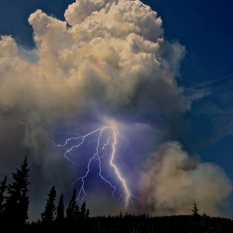
Stunning image captures lightning strike from wildfire’s pyrocumulus cloud
Weather of course clearly affects wildfires but fires themselves can literally create their own weather. One such phenomena are pyrocumulus clouds and a photo from a wildfire in Alaska provides a stunning example.
Pyrocumulus clouds are formed by fires or volcanos when the intense heat from the event rises from the surface. These clouds oftentimes look like dirty thunderstorm clouds directly over a blaze and can give rise to thunderstorm-like weather conditions.
Lightning from these clouds can occur and in particular when coupled with a volcanic eruption are absolutely amazing. With wildfires, the strong winds and lightning can result in dangerous and unpredictable expansion of a fire.
The Moon Lake Complex Fire is currently burning in eastern Alaska and has scorched over 18,000 acres. Inciweb posted a photo of a pyrocumulus cloud over the blaze near Tok that let loose a stunning bolt of lightning.
Satellite imagery captures explosion of West Fork Complex Fire, Papoose Fire and thunderstorms
Satellites provide an amazing eye in the sky for monitoring the weather and climate. Their usefulness today was once again proven as they captures wildfires exploding in Colorado’s southwest and thunderstorms to the northeast.
The satellite imagery animation comes from the NOAA GOES East satellite and was assembled by Colorado State University RAMSDIS. It covers the period from 1:55pm to 4:40pm on Friday, June 21, 2013.
The tandem West Form Fire and Papoose Fire in southwestern Colorado are seen sending massive smoke plumes into the sky. Afternoon thunderstorms are exploding in the northeastern corner of the state.
Internet resources for wildfire information and education

As wildfires burn across much on the western United States late this summer, the Internet can be a wealth of information for residents that are affected by these blazes or for anyone else. Resources are available for everything from the latest news updates, finding out where the fires are right down to the street level, to safety and education.
This list is by no means all inclusive – if you have a wildfire related link we are missing, please post a comment and let us know and we will update our list!
Updated 6/21/2013
- National Level Agencies
- Fire Mapping
- Weather
- Wildfire Imagery
- Wildfire Education & Information
- Wildfire Assistance
- State Agencies
- InciWeb – Incident Information
- National Interagency Coordination Center (NICC)
- National Interagency Fire Center (NIFC)
- Latest situation report (PDF) – Updated daily
- National Fire News – Updated daily
- Wildland Fire Statistics
- Historical Statistics
- National Park Service – Fire & Aviation Management
- U.S. Bureau of Land Management – Fire & Aviation
- U.S. Fish & Wildlife Service – Fire Management
- U.S. Forest Service (USFS) – Fire and Aviation Management
- USFS Geographic Coordination Centers
- USFS MODIS Active Fire Mapping Program
- NOAA Hazard Mapping System Fire and Smoke Product
- NOAA Satellite Fire Detections
- NOAA SSD Fire Detection Program – Fire and smoke maps
- USFS Active Fire Mapping Program
- USGS GeoMAC – Mapping
- USGS Active Fire Perimeter Map (Google Map)
- USGS Natural Hazards Support System
- National Weather Service
- NOAA Storm Prediction Center Fire Weather
- Rocky Mountain Area Coordination Center Outlooks
- MODIS Rapid Response System
- NASA Earth Observatory
- NOAA Environmental Visualization Laboratory (EVL)
- NOAA Satellite Services Division
Wildfire Education & Information
- Firewise – Information for homeowners and public policy makers about responsible planning
- Google search – Wildfire & forest fire education
- Google News search – Forest fires & wildfires
- Healthy Forests and Rangelands – Info about National Fire Plan (NFP), Healthy Forests Initiative (HFI), and related initiatives
- U.S. Fire Administration
- Smokey Bear
- USFS Fire Education
- Wildfire Today Blog
- Alabama Forestry Commission
- Alaska Division of Forestry
- Arkansas Forestry Commission
- California Department of Forestry & Fire Protection
- Colorado State Forest Service
- Connecticut Department of Environmental Protection
- Delaware Department of Agriculture
- Florida Division of Forestry
- Georgia Forestry Commission
- Hawaii Division of Forestry & Wildlife
- Idaho Department of Lands
- Illinois Divison of Forest Resources
- Indiana Division of Forestry
- Iowa DNR Forestry
- Kansas Forest Service
- Kansas Forest Service
- Kentucky Division of Forestry
- Louisiana Department of Agriculture & Forestry
- Maine Forest Service
- Maryland Forest Service
- Massachusetts Department of Conservation & Recreation – Forestry
- Minnesota Division of Forestry
- Mississippi Forestry Commission
- Missouri Department of Conservation – Forestry
- Montana DNRC Forestry Division
- Nebraska Forest Service
- Nebraska Forestry Service
- Nevada Division of Forestry
- New Hampshire Division of Forests and Lands
- New Mexico State Forestry
- New York Division of Environmental Conservation – Forests
- North Carolina Division of Forest Resources
- North Dakota Forest Service
- Ohio Division of Forestry
- Oklahoma Forestry Services
- Oregon Department of Forestry
- Pennsylvania Bureau of Forestry
- Rhode Island Division of Forest Environment
- South Carolina Forestry Commission
- South Dakota Resource Conservation & Forestry
- South Dakota Wildland Fire Suppression Division
- Tennessee Division of Forestry
- Texas Forest Service
- Utah Division of Forestry, Fire & State Lands
- Vermont Department of Forests, Parks & Recreation
- Virginia Department of Forestry
- Washington State Department of Natural Resources
- West Virginia Division of Forestry
- Wisconsin Division of Forestry
- Wyoming State Forestry Division
Australian family shares terrifying story, photos of escape from wildfire
Record-setting heat and tinder dry conditions have brought devastating bushfires to Australia in recent weeks, hitting the island state of Tasmania the hardest. One family’s harrowing escape was captured in terrifying detail with pictures of them fleeing to water to avoid the fast moving flames. Read the rest of this story on Examiner.com and check out the amazing photos.
")
NOAA names 2012’s deadly wildfire season one of top weather events for year
Colorado witnessed an absolutely devastating wildfire season in 2012. We were not alone however as many locations across the U.S. saw a year of record burning and yesterday NOAA named the wildfire activity one of its top weather and climate events of 2012. Read the rest of this story on Examiner.com
")
Australian Outback bushfire spawns amazing fire tornado
While North America has dealt with a deadly and devastating wildfire season, Australia as well has seen many bushfires rage across its wild lands. One fire in recent days burning near Alice Springs spawned a rare fire tornado that whirled through the Outback for 40 minutes. Read the rest of this story on Examiner.com and check out the amazing video.
")