|
|
Tag Archives: Wildfire
Video: NASA showcases weather and climate events of 2013 as seen from space
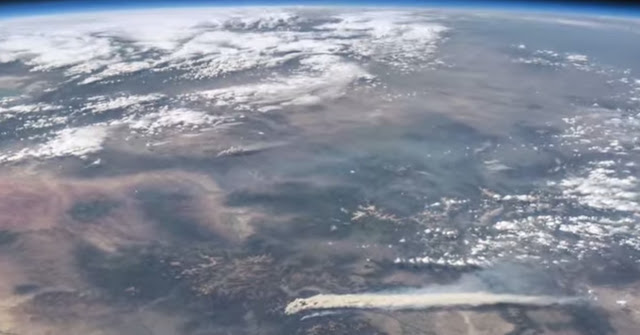
A stunning video released by NASA this week provides a bird’s eye view of some of the Earth’s most significant weather and climate events of last year.
Using images and movies from satellites and the International Space Station, scenes from across the globe are shown in the video titled “Earth from Orbit 2013.”
Colorado and surrounding states however will draw the most attention from many locally.
From their perch high above, imagery of Colorado’s West Fork Fire in June 2013 is seen as well as the effects of the September floods.
To our south, the drought in New Mexico is seen having taken its toll on Elephant Butte Reservoir in New Mexico. The veritable explosion of storm cells that lea to devastation in Oklahoma during a May tornado outbreak are also shown.
Below the video you will find a description of each scene and links to more imagery.
From NASA – Published on Apr 21, 2014:
A fleet of orbiting satellites monitors Earth constantly. The satellites from NASA and other space agencies give us a fresh, wide perspective on things that we can see from the ground — and things that we can’t.
A look back at Earth in 2013 from the viewpoint of orbit reveals the kind of data gathering and technical achievement that are the reason NASA puts Earth-observing satellites in space. A visualization of satellite and computer model data shows how a cloud of dust from the Chelyabinsk meteor moved around the world. NASA satellites measured the intensity of wildfires, the salinity of the oceans and rainfall around the globe — whether it was too little or too much.
To learn more about NASA’s Earth science in 2014, please visit: www.nasa.gov/earthrightnow
Imagery used in this video, in order:
Views of a Distant Earth
http://earthobservatory.nasa.gov/IOTD…
Earth and Moon
http://svs.gsfc.nasa.gov/vis/a000000/…
Current Earth Observing Fleet
http://svs.gsfc.nasa.gov/vis/a030000/…
Term3_ISS From Night to Day to Night Again
http://eol.jsc.nasa.gov/Videos/CrewEa…
Astronaut View of Fires in Colorado
http://earthobservatory.nasa.gov/Natu…
Extensive Ice Fractures in the Beaufort Sea
http://earthobservatory.nasa.gov/IOTD…
Dune Movement Around Aorounga
http://earthobservatory.nasa.gov/IOTD…
San Francisco Region at Night
http://earthobservatory.nasa.gov/IOTD…
Whiting Event, Lake Ontario
http://earth.jsc.nasa.gov/debrief/ISS…
Dust Plumes over the Mediterranean
http://earthobservatory.nasa.gov/Natu…
Mt. St. Helens
http://earthobservatory.nasa.gov/IOTD…
El Paso
http://earthobservatory.nasa.gov/IOTD…
Close-Up of Flooding in Mozambique
http://earthobservatory.nasa.gov/IOTD…
Drought Dries Elephant Butte Reservoir
http://earthobservatory.nasa.gov/IOTD…
Oklahoma Tornadoes
http://earthobservatory.nasa.gov/Natu…
Floods in Colorado
http://earthobservatory.nasa.gov/Natu…
Pavlof Volcano
http://earthobservatory.nasa.gov/Natu…
Swirling Sediment Reveals Erosive Power of New England Storm
http://earthobservatory.nasa.gov/IOTD…
Never at Rest: The Air over Los Angeles
http://svs.gsfc.nasa.gov/vis/a000000/…
Measuring Soil Moisture from Space
http://svs.gsfc.nasa.gov/vis/a030000/…
Antarctic Bedrock
http://svs.gsfc.nasa.gov/vis/a000000/…
Seeing Photosynthesis from Space
http://svs.gsfc.nasa.gov/vis/a010000/…
Greenland’s Mega Canyon
http://svs.gsfc.nasa.gov/vis/a000000/…
Chelyabinsk Bolide Plume as seen by NPP and NASA Models
http://svs.gsfc.nasa.gov/vis/a000000/…
Narrated Distributed Water Balance of the Nile Basin
http://svs.gsfc.nasa.gov/vis/a010000/…
NEO Observations (various)
http://svs.gsfc.nasa.gov/cgi-bin/advs…
Video: Dust devil strikes during controlled burn at Rocky Mountain Arsenal
 Performing prescribed burns is an important way to clear brush and renew wildland and are often done without any excitement. Mother Nature had other plans last week however as whirling winds propelled a fire beyond its containment lines at the Rocky Mountain Arsenal National Wildlife Refuge.
The amazing video of the event on March 14 was taken by a firefighter from South Metro Fire and showcases how quickly weather conditions can change and how even when well-planned, fires can quickly get out of control.
- Story republished with permission from the Denver Weather Examiner
The fire is seen burning through the grasslands of the refuge when swirling wind develops – a common phenomenon caused by the heat quickly rising from the fire. Soon the fire begins to rage and tumbleweeds and burning debris are sent flying in a circular path.
Thomas Rogers, the man behind the camera, said on YouTube the fire burned an additional acre as crews backed off to gain the upper hand.
Refuge Manager David Lucas said on Facebook, “What we saw and how we reacted is exactly what we want out of our fire crews — well planned with plenty of on-site resources to manage contingencies, safety first, and well trained folks who got after it quickly.”
Satellite imagery shows smoke plume from the High Park Fire in Larimer County
Now at 14,000 acres, the High Park Fire continues to grow unabated. Winds had shifted overnight sending the smoke over the metro area and Thornton but this afternoon they moved to the east. Satellite imagery, shown in the video below, clearly shows the smoke plume stretching through Colorado into Wyoming and Nebraska and starting to impact South Dakota.
Be sure to check out our Wildland Fire Activity and News page for the latest.
North Metro firefighters head to Arizona; Crews to battle massive wildfire
")
Four firefighters from North Metro Fire Rescue will be joining nearly 2,000 others from across the nation in battling a monstrous wildfire in Arizona. In less than two weeks the Wallow Fire has exploded to cover more than 600 square miles and sent smoke as far as the Denver area.
The hometown heroes from North Metro will be taking along a reserve fire engine to help battle the blaze. Two firefighters and a watertender from Eagle River Fire will round out a Colorado contingent of personnel with additional deployments possible.
- Slideshow: Firefighters from across the nation join the battle against the Wallow Fire (Examiner.com)
The fire, believed to have been started by an unattended campfire, has burned 389,000 acres making it the second largest fire in Arizona history. It is burning largely in the Apache National Forest in the eastern part of the state and now threatens to cross into New Mexico.
More than 3,000 firefighters from across the nation, 197 engines, 61 watertenders and 16 helicopters and a number of aerial tankers were battling the blaze as of this morning. Personnel and equipment continue to pour into the area.
Below is the latest on the blaze from Inciweb. For more coverage of the fire, visit the Natural Disasters Examiner.
Wallow Fire Update
For Immediate Release: June 9, 2011 9:00 a.m.
Fire Information: 928-333-3412 (Daily from 7:00 a.m. to 10:00 p.m.)
 Website Info: www.inciweb.org Twitter: www.twitter.com/AS NF
Flickr (photos): www.flickr.com/apachesitgreavesnf
Date Started: 5/29/2011
Number of Personnel: Approximately 3,012
Location: south and west of Alpine, Arizona
Including 24 hotshot crews and 79 handcrews
Cause: Human – under investigation
Equipment: 18 dozers, 197 engines, 61 watertenders
Size: 348,235 acres based on last night’s infared flight
Aircraft: 16 helicopters
Percent Contained: 0%
Injuries to Date: 3 minor injuries
Structures:
4,018 threatened; 1 damaged; 16 lost
Area Command Team 3 (Jim Loach, Area Commander) is now managing the Wallow Fire
Media should call 480-331-9554 to coordinate interviews.
There will be media briefings today at 10am and 9pm at the Rest Stop on Hwy 60, north of Springerville.
Current Evacuations
· Full evacuation of Eagar and Springerville. The evacuations were ordered by the Apache County Sheriff’s Office about 4:00 p.m. on June 8.
· Sunrise, Greer, Blue River, Alpine, Nutrioso, and the following subdivisions along highways 180/191: Escudilla Mountain Estates, Bonita, White Mtn. Acres, and the H-V Ranch. This area includes County Road (CR) 4000, CR 4001, and CR 4225.
· The evacuation center is located at Blue Ridge High School, 1200 W. White Mtn. Blvd., Pinetop-Lakeside.
Pre-Evacuation Alert
- A pre-evacuation alert has been issued by Apache County for Greens Peak, Hidden Meadow and the surrounding areas.
· A pre-evacuation alert has been issued by Catron County Sheriff’s Office for Luna, New Mexico.
- Residents in the communities affected by this fire are asked to remain prepared in the event an evacuation order is needed.
Residents with livestock or animals that need care should contact the Apache County Sheriff’s Office (928) 337-4321 or the Greenlee County Sheriff’s Office (928) 865-4149.
Road Closures
· The Arizona Department of Transportation reminds motorists traveling that the following closures on state highways remain in effect:
-more-
· Nearly 20 miles of U.S. 60 has been closed from Springerville to the New Mexico state line due
· to the Wallow Fire in eastern Arizona. This closure stretches from milepost 384 to 401.
· State Route 260 is closed in both directions east of the Hawley Lake turnoff (State Route 473 junction) and Eagar. SR 260 is closed between mileposts 372-398 near Eagar.
· State Route 373, a 4.5 mile-long highway that connects the town of Greer in eastern Arizona with SR 260 west of Eagar, is closed.
· U.S. 191 is closed between Alpine and north of Clifton (mileposts 176-253).
· State routes 261 and 273, the main access roads to Big Lake and Crescent Lake in the White Mountains, are closed. SR 261 is closed starting approximately seven miles south of SR 260 to Crescent Lake (mileposts 395-413) and SR 273 is closed between the SR 260 junction and to the SR 261 junction (mileposts 378-394).
· U.S. 180 is closed between the SR 260 junction near Eagar and the New Mexico state line (mileposts 403-433).
· For current road conditions , please visit http://www.azdot.gov/
Fire Update
Last night, fire crews concentrated their efforts prepping roads and dozer lines for burnout operations south of Route 851 and Circle Flat area that leads into New Mexico. Fire activity increased on the west side of the fire towards the communities of Greer and Eagar due to high wind and low humidity.
Crews are currently stationed at Big Lake to reduce travel times, ensuring firefighter safety. Structural protection is in place in Greer, South Fork, Eagar, Alpine, Nutrioso, and Escudillo Flats. Firefighters will be conducting burnout operations on the northern and eastern portions of the fire to p limit the fire’s spread. Firefighters continue to hold line, mop-up, and patrol other areas of the fire. Creeping, smoldering, and active backing fire with short upslope runs was observed yesterday on the southern portion of fire. Firefighters are constructing indirect line and conducting burnout operations. Today southwest winds of 8-15mph with gusts to 25 mph are expected.
Closures
Due to extreme fire conditions, the Apache National Forest is closed to all public entry. See website for closure order details. Please see the Forest website for more information:http://www.fs.fed.us/r3/asnf/.
Apache-Sitgreaves National Forests Fire Restrictions: A Temporary Emergency Closure Order
was issued effective June 3 at 12:00 p.m. (noon). For more information, please call the Arizona fire restrictions hotline 1-877-864-6985 or visit http://www.publiclands.org/firenews/AZ.php.
Public Information
For Wallow Fire Information, please visit http://www.inciweb.org/, www.twitter.com/AS NF, andwww.flickr.com/apachesitgreavesnf or call (928) 333-3412, (702) 308-3238, (702) 308-3357, or (702) 308-8227. Please let us know if you would like to receive updates via e-mail. Public information officers are also posting information in local communities and the evacuation center located at Blue Ridge High School in Pinetop-Lakeside.
Smoke from Arizona wildfire brings hazy conditions to the Colorado Front Range

Recent days have brought hazy conditions to the Denver area and all along the Colorado Front Range. At times residents have even smelled smoke and the culprit lies hundreds of miles to our south.
Two fires burning near Trinidad as well as one in southern New Mexico were attributed to the hazy conditions early last week. Now a massive fire in eastern Arizona is sending smoke our way and causing the horizon to be obscured
The fire burning 250 miles northeast of Phoenix has been dubbed the Wallow Fire and is burning through lush but dry forest. At latest estimates the blaze has scorched 144,000 acres making it the third largest blaze in Arizona’s history.
More than 1,300 firefighters from across the nation are on the scene and battling the blaze. Zero containment has been established but firefighters have made progress in recent days slowing its advance.
The images to the top right and below were taken by NASA and NOAA satellites and clearly show the smoke from the blaze.

The story of the Fourmile Canyon and Reservoir Road fires in pictures
")
It seems like it had been a while since Colorado suffered a major wildfire and summer had indeed passed quietly in those terms – until Labor Day.
Spurred on by strong winds and fed by tinder dry fuels the Fourmile Canyon Fire in Boulder County soon exploded and served as a reminder that the fire danger was still with us. Photos taken during that blaze and the Reservoir Road Fire tell a story of the battle of man against nature.
Wildfires can quickly grow from a small event to one that covers thousands of acres destroying property and sometimes claiming lives in the process. Colorado dodged a bullet with the Fourmile Canyon Fire and the Reservoir Road Fire as no lives were lost and there were very few injuries.
Many residents in the burn areas however suffered other losses — that of their home and virtually every belonging they owned. The events torched over 6,500 acres combined and the Fourmile Canyon Fire became the most destructive in state history in terms of homes destroyed, as 166 houses were lost.
 Photos taken from the outset of the first fire were impressive. Some were taken from right next to the fire as residents worked to save their homes; others were captured from 22,300 miles in space by NOAA satellites showing smoke traveling across three states.
The images in the slideshow to the left represent the best images captured by Examiner.com readers, the U.S. Forest Service and professional photographers. They tell a compelling story of the fight between man and fire and the battle to save lives and property.
Behind the scenes photos show the Fourmile Canyon Fire battle
")
Much like words have been used to tell the story of the Fourmile Canyon Fire and its destructive power, so too have photos and video. The U.S. Forest Service has released new photos taken by their crews that tell the story in a way that hasn’t been seen yet – from behind the fire lines.
On Monday the Fourmile Canyon Fire quickly exploded and soon smoke covered the Denver metro area. Video taken from a nearby mountain showed the orange glow of the flames as they advanced. The ferocity of the fire was such that NOAA satellites captured images of the smoke as it traveled as far as Iowa.
Over the week the fire became the worst in Colorado history in terms of the number of homes lost as 169 were destroyed. Images taken by helicopter from above showed mountain properties reduced to cinder.
The images taken by the U.S. Forest Service (USFS) are stunning testaments to the bravery of the firefighters on the scene. Photos of chainsaw wielding combatants, slurry bombers dropping their bright red retardant, and fire raging next to roadways tell the story from behind the lines.
You can view the new images by clicking on the slideshow image below.
 Below are links to other slideshows we published on Examiner.com over the past week.
- Day 1 – Fast moving wildfire burns northwest of Boulder, Colorado
- Day 2 – Fourmile Canyon Fire burns thousands of acres in Colorado mountains
- Day 3 – Fire continues to rage in Fourmile Canyon near Boulder
- Day 4 – Fourmile Canyon Fire becomes most destructive in Colorado history
- From space – Satellite images show devastation of Fourmile Canyon Fire
Also be sure to check out these pages:
Fire burning in Fourmile Canyon sends smoke over Thornton
")
A fast moving wildfire burning northwest of Boulder sent smoke over Thornton on monday and more is expected today. The Fourmile Canyon Fire started late Monday morning and has burned 3,500 acres thus far.
Tinder dry fuels, low humidity, warm temperatures and gusty winds fueled the Fourmile Canyon Fire yesterday as it grew quickly. Firefighters took up defensive positions trying to save what homes they could but many were reduced to cinder.
More than 100 firefighters are on scene with 35 engines from 30 local agencies. Boulder County Fire is acting as the primary agency for the fire.
High winds prevented air tankers with retardant from operating for most of the day but the wind eased in the late afternoon and evening allowing some operations. 18 flights by three tankers were carried out before the sun set and they were able to drop 40,000 gallons of retardant on the fast moving fire.
Four additional tankers arrived Monday and will begin operations today, weather permitting.