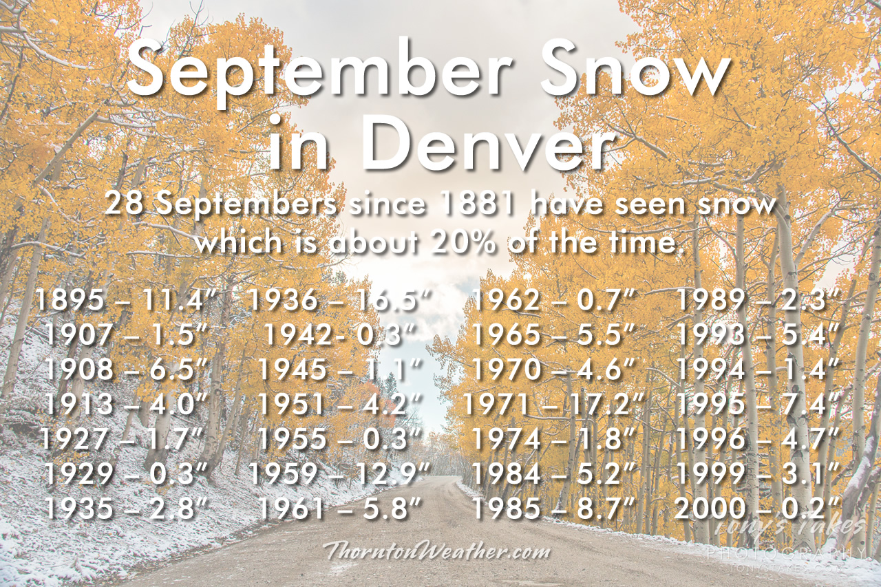
Weather conditions in Colorado can of course vary greatly and we always see that in our weekly look back in the history books. For this week, we see a dizzying array of weather events from record setting temperatures in the 90’s and summer-like thunderstorms with tornadoes to an early arrival of winter that brought a foot of snow!
From the National Weather Service:
5-13
In 2010…the Fourmile Canyon wildfire…northwest of Boulder… Broke out on the morning of the 5th. It originated from an unattended fire pit at a local residence. The wildfire quickly consumed 5 1/2 square miles or 3500 acres the first day…and forced the evacuation of over three thousand residents. Erratic 45-mph gusts sent the fire in two directions at times. Very dry weather conditions preceded the fire. The combination of strong winds…low relative humidities and dry fuels allowed the wildfire spread rapidly through the steep…heavily forested terrain. The flames were reportedly 20 to 50 feet in length. Towns within the burn area included Salina…Wallstreet and Gold Hill. The dry conditions coupled with gusty winds ranging from 45 to 64 mph persisted for several more days. Fire managers used as many as 700 firefighters and support personnel from 35 agencies and seven air tankers to battle the wildfire. A total of 6181 square acres or approximately 10 square miles were burned. The Fourmile Canyon wildfire was the most destructive fire in Colorado history in terms of the damage to personal property. It destroyed 171 homes with an estimated cost of 217 million dollars.
11-16 in 2013…a deep southerly flow over Colorado… Ahead of a nearly stationary low pressure system over the great basin… Pumped copious amounts of monsoonal moisture into the area. In addition…a weak stationary front stretched along the Front Range foothills and Palmer Divide. This resulted in a prolonged period of moderate to heavy rain across the Front Range foothills…Palmer Divide…urban corridor. By the 14th…storm totals ranged from 6 to 18 inches… Highest in the foothills of Boulder County. The headwaters then moved down the South Platte River and caused widespread flooding with record flood stages at several locations as it made its way downstream. The record high flood stages resulted in widespread flooding along the South Platte River basin. The flood damage encompassed 4500 square miles of the Front Range…left 7 dead… Forced thousands to evacuate…and destroyed thousands of homes and farms. Record amounts of rainfall generated flash floods that tore up roads and lines of communication… Leaving many stranded. Nearly 19000 homes were damaged… And over 1500 destroyed. Colorado department of transportation estimated at least 30 state highway bridges were destroyed and an additional 20 seriously damaged. Preliminary assessments of the state`s infrastructure showed damage of $40 million to roads and $112 million to bridges. Repair costs for state and county roads ran into the hundreds of millions of dollars. Miles of freight and passenger rail lines were washed out or submerged… Including a section servicing Amtrak`s iconic California Zephyr. The town of Lyons was isolated by the flooding of St. Vrain creek…and several earth dams along the Front Range burst or were over-topped. Floodwaters swept through Estes Park; damaged hundreds of buildings and destroyed large sections of U.S. 34 from Loveland and U.S. 36 from Lyons to Boulder. U.S. 34 suffered the most damage… With 85 percent of its roadway and bridges destroyed. In Weld County…about nearly two thousand gas wells were damaged and had to be closed off as the floodwaters inundated entire communities. Sewage treatment plants and other utilities were knocked out in a number of towns. Governor Hickenlooper declared a disaster emergency on September 13th…in 11 counties across northeast Colorado including: Adams…Arapahoe…Broomfield…Boulder…Denver… Jefferson…Larimer…Logan…Morgan… Washington and Weld. By the 15th…federal emergency declarations covered those counties as well as Clear Creek County. Projected losses from the flooding statewide was nearly two billion dollars in property damage…according to Eqecat… A catastrophe modeling firm. The damage was most severe in and around Lyons and Boulder. More than 11 thousand people were evacuated…reportedly the largest since Hurricane Katrina. President Obama declared a state of emergency for Boulder and Larimer counties. An additional 10 counties were added on the 16th and included: Adams… Arapahoe…Broomfield…Clear Creek…Denver…Jefferson… Morgan…Logan… Washington and Weld counties. The president also declared a major disaster specifically for Boulder County. There were six fatalities directly attributed to flash flooding. Two 19-yr old teenagers died on the 11th…after they were swept away by floodwaters after abandoning their car on Lindon Drive in Boulder. In Jamestown…a 72-yr old man was killed when the building he was in collapsed. An 80-yr old Lyons resident died in the early morning hours of the 12th…when his truck was swept into the St. Vrain River near his home. Later on the 12th…a 79-yr old Larimer County resident was killed when she was swept away while trying to climb to safety from her home in Cedar Point. A 61-yr old cedar point resident died when her home was swept down the Big Thompson River by the floodwaters. An 80-yr old Idaho Springs resident drowned in Clear Creek when the embankment he was standing on collapsed. In Boulder…some of the monthly records broken included: one-day all-time record: 9.08 inches which shattered the previous wettest day of 4.8 inches set on July 31… 1919; one-month record of 18.16 inches…which broke the previous all-time monthly record of 9.59 inches set in May of 1995; wettest September on record which broke the previous record of 5.5 inches set in September of 1940; one-year record of 34.15 inches broke the previous wettest year of 29.93 inches set in 1995. At Denver International Airport…the total precipitation for the month of September was 5.61 inches…which was 4.65 inches above the normal of 0.96 inches. This is the most precipitation ever recorded in Denver for the month of September. Daily precipitation records included 1.11 inches on the 12th and 2.01 inches on the 14th.
13
In 1899…west winds were sustained to 43 mph with gusts to 46 mph.
In 1928…northwest winds were sustained to 41 mph with gusts to 45 mph.
In 1937…an apparent dry microburst produced brief north winds sustained to 31 mph with gusts to 41 mph. There was a trace of rain.
In 1982…torrential rains drenched both the foothills and plains from Denver north. While the heaviest rain occurred north of Denver…just east of Denver 2 1/3 inches of rain fell in 5 hours along with hail that caused minor damage to a few airplanes. Thunderstorm rainfall totaled 0.83 inch at Stapleton International Airport.
In 1993…an upper level system combined with a cold and moist upslope flow to bring the heaviest snowfall to metro Denver for so early in the season. Snowfall from the storm totaled 5.4 inches at Stapleton International Airport; however…most of the snow melted as it fell leaving a maximum of one inch on the ground at any one time. North winds gusted to 21 mph at Stapleton International Airport where a record low temperature of 33 degrees for the date was observed.
In 2002…Friday the 13th proved to be bad luck for several motorists when heavy thunderstorm rainfall caused flooding on I-25 in central Denver. Water rose several feet under the Logan Street overpass…inundating several vehicles. Some motorists were rescued…while others simply waited atop their cars for the flood water to recede. The highway had to be closed in both directions for about 3 hours. The flooding was exacerbated by poor drainage due to the construction along the highway. A 12-foot drainage pipe had not yet been installed beneath the underpass. The deluge also flooded several businesses along Broadway.
In 2009…a severe thunderstorm produced large hail… Up to half dollar size in the foothills of Jefferson County…west of Denver.
14
In 1912…snow fell for most of the day…but melted as it fell. Precipitation from melted snow was 0.46 inch. Some sleet was also observed. Total precipitation was 0.61 inch. North winds were sustained to 15 mph with gusts to 17 mph.
In 1934…a moderate dust storm blew into the city at 4:15 pm. North winds were sustained to 35 mph with gusts to 44 mph. By 5:25 pm the winds had decreased and the storm had ended. A trace of rain fell during the evening.
In 1976…a tornado touched down just west of I-25 between Arapahoe Road and Dry Creek Road…tearing the roof from a house. Nearby…a high tension wire fell on a house causing damage…and lightning ripped a hole in the side of a house. Three tornadoes were observed just east of Stapleton International Airport and northeast of Buckley Field. No damage was reported. Dime to quarter size hail fell in northeast Denver with only 1/4 inch hail at Stapleton International Airport. The Colorado State Patrol reported golf ball size hail 4 miles west of Franktown. A funnel cloud was sighted 4 miles north of Franktown.
In 1983…a thunderstorm produced winds gusts as high as 56 mph across metro Denver along with thick blowing dust. Power was knocked out in many locations. Thunderstorm winds gusting to 49 mph briefly reduced the visibility to 2 miles in blowing dust at Stapleton International Airport.
In 1996…a 54-year-old woman was struck by lightning near Franktown…as she was preparing an outdoor barbeque. The woman was knocked unconscious…but received only minor injuries. Thunderstorms over southern Jefferson County dumped heavy rain in the buffalo creek area. Some minor roads were washed out by flash flooding…but no other damage was reported. Hail ranging in size from 1/2 to 3/4 inch in diameter fell at the site of the former Stapleton International Airport.
In 2006…a microburst from a thunderstorm produced sustained winds to 40 mph with gusts to 53 mph at Denver International Airport.
Continue reading September 13 to September 19: This week in Denver weather history

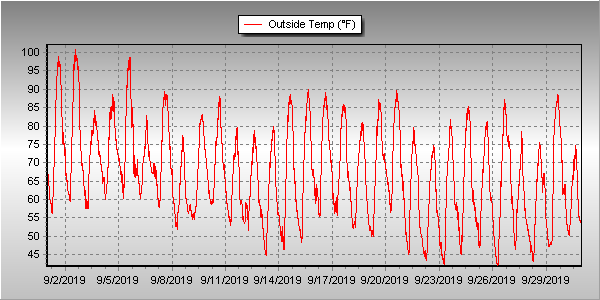
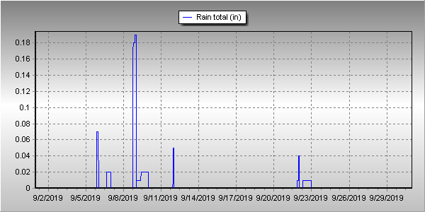
 Following an August that was unseasonably warm and dry, we find ourselves heading into September hoping for relief. The month can bring plenty of rain and even our first snow of the season but more often than not, it is one of the most pleasant along the Colorado Front Range.