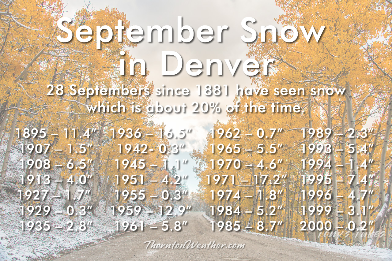
With the end of summer and the arrival of fall, looking back at Denver weather history we start to see more mentions of snow. It is of course not the only notable weather event this time of year. We still have received severe thunderstorms, damaging winds, and 90 degree plus heat.
From the National Weather Service:
From the 25th to the 27th:
in 1996…an early season snowstorm brought heavy snow to the Front Range eastern foothills. Snowfall totals included: 8 to 12 inches around Conifer…7 inches on Floyd Hill…and 6 inches at both bailey and Chief Hosa. Snowfall totaled only 4.7 inches at the site of the former Stapleton International Airport. This was the first measurable snow of the season. After the passage of a strong cold front…north winds gusted to 38 mph at Denver International Airport on the 25th.
From the 26th to the 28th:
In 1936…the heaviest snowfall ever recorded in September and the heaviest snowfall ever recorded so early in the season dumped a total of 16.5 inches of snow on downtown Denver and 21.3 inches at Denver municipal airport. The 15.0 inches of snow measured from 6:00 pm on the 27th to 6:00 pm on the 28th is the greatest 24 hour snowfall ever recorded in September. This was the first snow of the season. The snow was intermittent through the 26th…but continuous from early afternoon on the 27th to around midnight on the 28th…except for a period of rain during the afternoon of the 28th which contributed to a loss of depth on the ground. The greatest snow depth on the ground downtown was 13 inches with 8 inches at Denver municipal airport. There were no high winds with the storm and traffic was interrupted for only a short period. The storm produced property damage estimated at 7 million dollars. With trees and shrubs in full foliage…the leaves caught and held the heavy water-laden snow…until the branches snapped from the weight. More than 3000 workmen were called to remove the debris and snow from the city. The city firemen who were off duty…as well as all the reserves… Were asked to report to their stations. All schools in the city remained open…but attendance was only 50 percent of normal. Grade school students were sent home at noon on the 28th. The early storm caught stockmen with many cattle still in higher ranges. Warm weather followed the snow…which had all melted by the end of the month…except for a few inches in sheltered places.
On the 27th:
In 1877…smoke from heavy forest fires in the mountains spread over the city on upper wind currents.
In 1935…the first snow of the season was 2.8 inches in downtown Denver. The low temperature dipped to 31 degrees for the first freeze of the season.
From the 27th to the 28th:
In 1984…heavy snow fell over the plains and foothills. Snowfall amounts ranged from 2 to 5 inches on the plains with up to a foot at higher elevations in the foothills. The main problem caused by the storm was thousands of power outages caused by snow-laden tree limbs snapping and falling onto power lines. Over 15 thousand homes lost power in metro Denver. Some cars were damaged by falling trees and limbs. The snow also caused some flight delays at Stapleton International Airport where 5.1 inches of snow fell and northeast winds gusted to 29 mph. Maximum snow depth on the ground was 3 inches due to melting. The high temperature of only 34 degrees on the 28th was a record low maximum for the date and equaled the all-time record for the month at that time.
On the 28th:
In 1877…heavy dense smoke from mountain forest fires spread over the city. The smoke was so dense that it obscured the sun at times.
In 1921…post-frontal northeast winds were sustained to 44 mph.
In 1953…a pacific cold front produced a west wind gust to 59 mph at Stapleton Airport where the visibility was briefly reduced to 3/4 miles in blowing dust. Strong winds were also widespread over Boulder during the afternoon.
In 1960…strong…gusty winds tore the roof from 6 units of a motel on west Colfax Avenue in Denver. The roofing sailed over the building and crashed down on a truck…wrecking it. The strong winds were the result of an apparent microburst.
In 1999…snow fell in the foothills west of metro Denver and over the plains. Snowfall totals included 7 inches at Conifer. At the site of the former Stapleton International Airport…3.1 inches of snow were measured. This was the first snow of the season. The heavy wet snow snapped branches from fully leafed trees…downing power lines and causing scattered outages.
In 2004…severe thunderstorms produced hail to 3/4 inch in diameter in Littleton and in Douglas County 14 miles northwest of Castle Rock.
In 2012…a weak tornado (ef-0) tornado touched down near Strasburg. No damage was reported.
From the 28th to the 29th:
In 1959…one of the heaviest September snow storms of record began as rain and changed to heavy wet snow. The storm caused heavy damage to trees and shrubbery…which were still in full leaf. The storm dumped 10.6 inches of snow at Stapleton Airport…the third heaviest September snow amount to date. Falling trees and limbs disrupted traffic…broke power and communication lines…and damaged buildings and cars. One man was killed in Denver by a falling tree limb…and four others died of heart attacks while shoveling snow or trying to move heavy tree limbs. Direct costs of the storm for cleaning up debris…repairing utility lines…and damage to buildings and other property across all of eastern Colorado were estimated to be over a half million dollars. The value of trees destroyed or damaged was estimated to exceed five million dollars. North-northeast winds gusted to 32 mph at Stapleton Airport on the 28th.
In 1985…an unusually cold air mass for this time of year settled over the area. Metro Denver received 8 to 12 inches of powdery snow. The 8.7 inches of snow that fell at Stapleton International Airport was the first measurable snow of the season and the city’s heaviest September snowfall since 1971. The snow caused flight delays of over 2 hours at Stapleton International Airport. I-70 was closed for a time west of Denver. Snow-laden tree limbs snapped over all of metro Denver…causing widespread power outages. Ten thousand people were without electricity for a time in Boulder. The morning of the 29th saw mid-winter temperatures along the Front Range. The temperature dipped to 17 degrees…the lowest temperature ever recorded in September in Denver. The high temperature of only 29 degrees on the 29th was a new record low maximum for the date and lowest ever recorded during the month of September. The low temperature of 21 degrees on the evening of the 28th set a new record low for the date. The cold weather persisted through the 1st with record minimum temperatures of 25 degrees set on the 30th and 27 degrees set on October 1st.
On the 29th:
In 1966…a vigorous cold front moved thru metro Denver. North winds gusting to 51 mph kicked up billows of blowing dust…which briefly reduced the visibility to 1 mile at Stapleton International Airport. The cold air caused temperatures to drop rapidly from a high of 86 degrees to a low of 46 degrees by days end.
In 1985…the lowest temperature ever recorded in September… 17 degrees…occurred. The high temperature warmed to only 29 degrees…the all-time record low maximum for the month.
In 1994…the temperature reached a high of 91 degrees at Stapleton International Airport. This was the 60th day of the year that the temperature had reached 90 degrees or more…establishing a new record at that time. The previous record of 52 “90 degree days” occurred in 1978. Only 43 “90 degree days” were recorded at Denver International Airport during 1994.
In 1995…lightning struck a couple in Aurora as they were walking in the rain. The bolt struck the umbrella the man was carrying…injuring both the man and his wife.
In 2000…late afternoon thunderstorms produced strong wind gusts to 76 mph in Westminster…to 69 mph near Boulder…and to 60 mph at Jefferson County airport near Broomfield. No damage was reported.
In 2014…a storm system that moved through the area produced large hail and street flooding in parts of metro Denver and then spread east into the plains. The storm also caused multiple accidents. A semi became detached from a trailer… Blocking traffic on westbound Interstate 70 west of Tower Road. Downed power poles blocked a roadway on CO 79 near Bennett…at mile marker 10. In addition to the damaging winds…the storms produced large hail… From nickel to golfball size across southern and eastern portions of metro Denver. The hailstorm was the most damaging of the 2014 summer season…with insured losses that topped 213 million dollars. Insurance claims included 29297 automobile claims worth more than 87.2 million dollars and 14287 property claims for 126 million dollars…ranking the storm as the eighth most expensive to hit the state. At Denver International Airport…1.01 inches of rainfall was recorded which was the greatest 24-hr rainfall for the date. In addition…a peak wind gust to 38 mph was observed at the airport.
In 2015…severe thunderstorms developed over the foothills of Boulder County and Jefferson Counties…then moved south along the western suburbs of Denver. Areas north of Golden… around Lakewood and into northern Douglas County saw the heaviest rain and hail. The hail ranged in size from nickel to ping pong size.
On the 30th: Continue reading September 27 to October 3: This week in Denver weather history

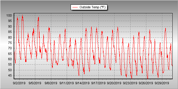
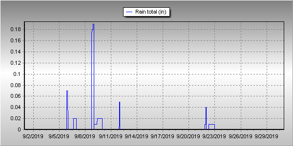
 Following an August that was unseasonably warm and dry, we find ourselves heading into September hoping for relief. The month can bring plenty of rain and even our first snow of the season but more often than not, it is one of the most pleasant along the Colorado Front Range.