The unstable, cold and wet weather that marked February continued right on into March. Once again, we saw temperatures well below normal and a good bit more than average precipitation.
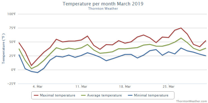
While the first day of the month started things off relatively nicely, the second brought the first bout of cold. Temperatures plummeted with highs on the third only in the single digits and nighttime low temperatures below zero on the 3rd and 4th. This was coupled with a nice shot of 3.4 inches of snow on the 3rd.
We then slowly warmed up and enjoyed near normal temperatures for a brief period of time. This changed quickly and significantly with the arrival of a blizzard on the 13th. Powerful winds coupled with snow shut down schools, businesses, highways and Denver International Airport.
Calmer, drier weather then took hold for much of the rest of the month although most days continued to see temperatures below normal. The 26th and 27th did offer up our first days of 70 degree or warmer temperatures.
The month closed out with another shot of cold on the 29th and 30th and a light bit of snow.
Thornton’s overall average temperature for the month of March was 35.1 degrees. Out at Denver International Airport here the Mile High City’s official measurements are taken, they matched our temperature with an average of 35.1 degrees as well. Both were well below the historical average March temperature for Denver of 40.4 degrees.
Temperatures in Thornton ranged from a maximum reading of 74.9 degrees on the 27th down to a low of -5.0 degrees on the morning of the 4th. Denver saw its maximum of 73 degrees on the 27th and its minimum of -6 degrees on the 3rd.
Denver set a record low maximum for March 3rd when the temperature only reached a high of 6 degrees. The old record was 14 degrees set in 1978. Additionally, a low temperature reading of -3 degrees on the 4th tied the record low for the date also set in 1960 and 1978.
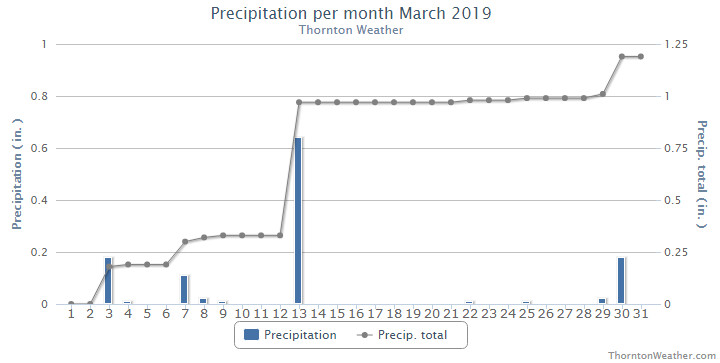
In terms of precipitation, Thornton recorded 1.19 inches in our bucket while Denver bested us with 1.39 inches. Both were above the long term Denver average for the month of March of 0.92 inches.
Denver’s 0.64 inches of liquid precipitation on the 13th set a daily record, easily besting the old record of 0.43 inches (1926) for the date.
Denver averages 10.7 inches of snow during the month of March. Thornton and Denver beat the average with measurements of 12.2 inches and 12.9 inches respectively.
Click here to view Thornton’s March 2019 climate report.
CLIMATE REPORT
NATIONAL WEATHER SERVICE DENVER/BOULDER CO
938 AM MDT MON APR 1 2019

...................................

...THE DENVER CO CLIMATE SUMMARY FOR THE MONTH OF MARCH 2019...

CLIMATE NORMAL PERIOD 1981 TO 2010
CLIMATE RECORD PERIOD 1872 TO 2019

WEATHER         OBSERVED          NORMAL  DEPART  LAST YEAR`S
                 VALUE   DATE(S)  VALUE   FROM    VALUE  DATE(S)
                                          NORMAL
................................................................
TEMPERATURE (F)
RECORD
 HIGH              84   03/26/1971
 LOW              -11   03/28/1886
HIGHEST            73   03/27                         73  03/22
LOWEST             -6   03/03                         13  03/07
AVG. MAXIMUM     46.7              54.4    -7.7     58.5
AVG. MINIMUM     23.5              26.4    -2.9     26.8
MEAN             35.1              40.4    -5.3     42.7
DAYS MAX >= 90      0               0.0     0.0        0
DAYS MAX <= 32      3               1.9     1.1        0
DAYS MIN <= 32     28              23.6     4.4       27
DAYS MIN <= 0       3               0.1     2.9        0

PRECIPITATION (INCHES)
RECORD
 MAXIMUM         4.56   1983
 MINIMUM         0.03   2012
TOTALS           1.39              0.92    0.47     1.02
DAILY AVG.       0.04              0.03    0.01     0.03
DAYS >= .01         9               5.9     3.1        6
DAYS >= .10         6               2.4     3.6        3
DAYS >= .50         1               0.3     0.7        0
DAYS >= 1.00        0               0.1    -0.1        0
GREATEST
 24 HR. TOTAL    0.64   03/13 TO 03/13           03/18 TO 03/18

SNOWFALL (INCHES)
RECORDS
 TOTAL           12.9              10.7
RECORD MARCH     35.2    2003

DEGREE_DAYS
HEATING TOTAL     919               763     156      684
 SINCE 7/1       5336              5202     134     4741
COOLING TOTAL       0                 0       0        0
 SINCE 1/1          0                 0       0        0

FREEZE DATES
RECORD
 EARLIEST     09/08/1962
 LATEST       06/08/2007
EARLIEST                        10/07
LATEST                          05/05
.................................................................

WIND (MPH)
AVERAGE WIND SPEED              10.2
RESULTANT WIND SPEED/DIRECTION   1/060
HIGHEST WIND SPEED/DIRECTION    60/340    DATE  03/13
HIGHEST GUST SPEED/DIRECTION    80/340    DATE  03/13

SKY COVER
POSSIBLE SUNSHINE (PERCENT)   MM
AVERAGE SKY COVER           0.60
NUMBER OF DAYS FAIR            4
NUMBER OF DAYS PC             16
NUMBER OF DAYS CLOUDY         11

AVERAGE RH (PERCENT)     67

-  INDICATES NEGATIVE NUMBERS.
R  INDICATES RECORD WAS SET OR TIED.
MM INDICATES DATA IS MISSING.
T  INDICATES TRACE AMOUNT.