Update: Tuesday, October 27th, 2009 5:15pm
A major early winter storm is on track to become the state’s first major snowstorm of the season. Areas in the mountains adjacent to the Denver Front Range may be measuring the snow in feet while parts of the Denver area could see up to a foot.
A cold front and trough dipping down from the north combined with a low pressure system moving over southern Colorado will combine creating a ‘perfect storm’ of sorts. Showers will begin spreading from the mountains this evening initially in the form of rain. As temperatures cool, that will change to snow, likely after midnight. Initially most of the precipitation will be west of I-25.
By Wednesday morning, up to 2 inches may have fallen in the Denver area and 3 – 4 inches in the foothills. As dawn breaks, conditions become ripe for a major storm as the upslope flow starts to kick in. The morning rush hour might be tolerable but by the time the afternoon arrives, things will be much different. At times during the day areas may see snowfall rates of 1 to 2 inches PER HOUR. Gusty winds will make for low visibility conditions and blowing and drifting snow.
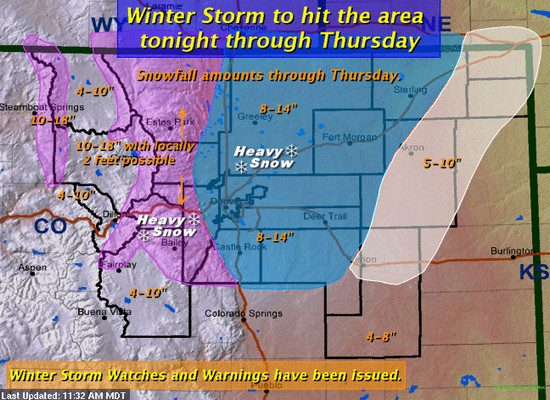
Through Wednesday afternoon, 5 – 12 inches are forecast for areas west of a Fort Morgan to Limon line. Lighter amounts east of that and higher amounts from 12 to 24 inches are possible in the high mountain areas. By the time the storm wraps up on Thursday, Denver may receive 8 to 14 inches with some spots receiving up to 20 inches. There remain some questions as to when the snow will actually end and that will ultimately determine the snow totals.
- See below for a forecast snow total map.
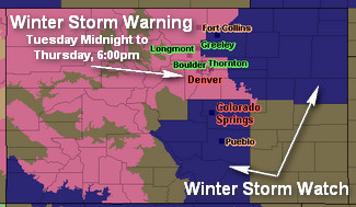
A Winter Storm Warning will go into effect from midnight through 6:00pm Thursday for the Front Range. The warning area also extends west to the Utah border and south to the Four Corners. The northeastern corner of Colorado along I-76 will be under a Winter Storm Watch from Wednesday morning through Thursday afternoon.
The warning issued from the National Weather Service sums it up nicely:
Residents should prepare for a long period of winter storm conditions with difficult or impossible travel on Wednesday and Thursday. Expect conditions to deteriorate considerably during the morning Wednesday. Consider completing travel before the storm if possible. If you must travel Wednesday or Thursday…take along a winter survival kit.
ThorntonWeather.com is of course your source for local information on the storm as it develops. We will also be updating the Denver Weather Examiner site as things develop. Here are some quick links to pages you may find handy:
- Current Advisories and Warnings
- ThorntonWeather.com Denver Doppler Radar
- Live Conditions in Thornton
- ThorntonWeather.com Weather Webcams
- Current Road Condtions
- Follow ThorntonWeather.com on Twitter
- And of course check out the Denver Weather Examiner
Why do we link to Examiner.com? Click here to find out.

Update: Tuesday, October 27th, 2009 8:30am MDT
A major early winter storm is poised to strike Colorado tonight in an event that will last two days. By the time the storm is over, some areas in the state will be measuring the snow in feet.
Tuesday’s forecast doesn’t look too bad but that doesn’t really give an indication of what is to come tonight. Rain and snow in the mountains later this morning will begin to move across the plains and the Denver area this evening. Initially the precipitation will be rain but that will change to snow overnight.
By Wednesday morning snow is forecast to be falling across much of the Front Range and it will begin accumulating. There will be heavier periods of snow in which it will pile up quickly. The snow is expected to continue throughout the day Wednesday and overnight into Thursday morning.
Areas in the mountains, foothills and Palmer Divide may see more than a foot of snow before the storm moves out Thursday. For the Denver metro area, 8 to 14 inches are possible with greater amounts to the west and south. Needless to say, the storm is likely to greatly impact travel throughout the region, especially from Wednesday afternoon through Thursday morning. School and business closures are possible and highways, particularly those susceptible to blowing snow, may be closed as well.
In anticipation of the storm the National Weather Service has issued a Winter Storm Warning that encompasses much of the state from Denver west to the Utah border and south to the Four Corners. For the Front Range, the warning goes into effect at midnight tonight and runs through Thursday at 6:00pm. The northeastern corner of Colorado and the south I-25 corridor through Pueblo to New Mexico will be under a Winter Storm Watch from Wednesday morning through Thursday afternoon.
People planning travel across northeast and north central Colorado should be prepared for hazardous driving conditions. Roads will become snow covered by heavy snow and blowing snow. Chain laws will likely be required over the higher mountain passes for semi-trailers and buses…and roads closures will be possible. Travel will become very hazardous or impossible. If you must travel Wednesday or Thursday…take along a winter survival kit
~ NWS Winter Storm Warning
Of course any weather forecast comes with an asterisk. This entire setup is dependent on the low pressure system that is moving across the southern part of Colorado. For the storm to happen as forecast, it needs to establish itself over the southeastern corner of the state. Any movement toward another direction could leave us high and dry. Having said that, right now confidence in the forecast is pretty high and we are likely going to receive our first major storm of the winter season.
Original Post: Monday, October 26th, 2009 4:58pm MDT

Our cool October is about to get a lot colder and possibly considerably whiter. As we discussed in the morning forecast and have been talking about in recent days on Examiner.com, events are coming together to set Denver up for its first major winter storm of the season.
A trough dipping down from Canada coupled with a low pressure system moving into southern Colorado are forecast to provide the ingredients for up to 12 inches of snow along the Front Range. Mother Nature is anything but predictable and we are still 48 hours away so things can change but right now the forecast looks to be holding true.
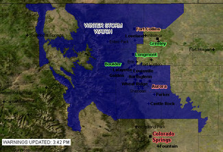
The National Weather Service has issued a Winter Storm Watch that will go into effect Wednesday morning and run through Wednesday night. The entire Denver metro area, the Front Range foothills and the northern mountain areas this side of the Continental Divide are under the watch advisory.
Tuesday evening we will begin to see some rain showers develop and after midnight and into Wednesday morning as temperatures drop that will change to snow. There is the potential for heavy snowfall all day Wednesday and into Wednesday night. Accumulations from 6 to 12 inches are possible, with higher amounts in areas that experience upslope conditions. Gusty winds from the north and northeast will reduce visibility and produce blowing and drifting snow.
Remember, a Winter Storm Watch means there is a potential for a hazardous winter weather event in and close to the watch area. Significant snow accumulations may occur that could impact travel.
ThorntonWeather.com is of course your source for local information on the storm as it develops. We will also be updating the Denver Weather Examiner site as things develop. Here are some quick links to pages you may find handy:
- Current Advisories and Warnings
- ThorntonWeather.com Denver Doppler Radar
- Live Conditions in Thornton
- ThorntonWeather.com Weather Webcams
- Current Road Condtions
- Follow ThorntonWeather.com on Twitter
- And of course check out the Denver Weather Examiner
Why do we link to Examiner.com so much? Click here to find out.
