Cold and snow. Those were certainly the operative words for the month of February 19. Thornton recorded its coldest February in the past 12 years and its snowiest month overall since March 2016.
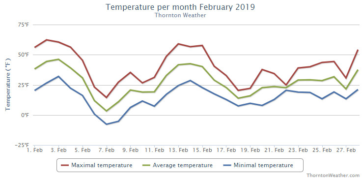
Mild temperatures started things off for the first four days of the month and fooled us into thinking of an early spring. Those dreams were soon crushed though as the first extended period of below normal temperatures arrived on the 6th. Six straight days of below normal temperatures then arrived as did our first shot of snow for the month.
We rebounded briefly for a four day period from the 12th to the 15th with mild temperatures. Once again though, the mercury plunged delivering 13 straight days of below normal temperatures and five days of measurable snowfall.
Thornton recorded an average temperature for the month of 26.3 degrees. This was our coldest February since ThorntonWeather.com came online in 2007 – by more than two degrees. Out at Denver International Airport where the Mile High City’s official readings are taken it was slightly warmer with an average of 28.0 degrees. Both were well below Denver’s long term February average of 32.5 degrees for February.
While certainly cold, neither average reading for the month could crack Denver’s list of top 10 coldest Februarys.
Thornton saw its warmest mercury reading for the month of 62.3 degrees on the second. Its coldest reading of -7.7 degrees came on the 7th of the month. Denver saw a maximum of 65 degrees on the 3rd and its low of -11 degrees on the 7th.
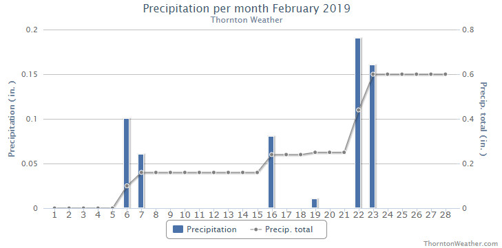
February is usually a dry month with Denver averaging 0.37 inches of liquid precipitation. Thornton recorded 0.60 inches this year while Denver saw 0.72 inches.
Similarly, snow was a good bit above normal for February as well. Thornton saw 11.2 inches of the white stuff while out at the airport 13.4 inches was recorded.
Click here to view Thornton’s January 2019 climate report.
CLIMATE REPORT
NATIONAL WEATHER SERVICE DENVER/BOULDER CO
555 AM MST FRI MAR 1 2019

...................................

...THE DENVER CO CLIMATE SUMMARY FOR THE MONTH OF FEBRUARY 2019...

CLIMATE NORMAL PERIOD 1981 TO 2010
CLIMATE RECORD PERIOD 1872 TO 2019

WEATHER         OBSERVED          NORMAL  DEPART  LAST YEAR`S
                 VALUE   DATE(S)  VALUE   FROM    VALUE  DATE(S)
                                          NORMAL
................................................................
TEMPERATURE (F)
RECORD
 HIGH              80   02/10/2017
 LOW              -25   02/01/1951
                        02/08/1936
HIGHEST            65   02/03
LOWEST            -11   02/07
AVG. MAXIMUM     40.8              46.2    -5.4     44.4
AVG. MINIMUM     15.3              18.9    -3.6     15.4
MEAN             28.0              32.5    -4.5     29.9
DAYS MAX >= 90      0               0.0     0.0        0
DAYS MAX <= 32      8               3.9     4.1        6
DAYS MIN <= 32     26              26.9    -0.9       26
DAYS MIN <= 0       3               1.3     1.7        3

PRECIPITATION (INCHES)
RECORD
 MAXIMUM         2.01   1934
 MINIMUM         0.01   1970
TOTALS           0.72              0.37    0.35     0.31
DAILY AVG.       0.03              0.01    0.02     0.01
DAYS >= .01         6               5.3     0.7        5
DAYS >= .10         3               0.7     2.3        2
DAYS >= .50         0               0.0     0.0        0
DAYS >= 1.00        0               0.0     0.0        0
GREATEST
 24 HR. TOTAL    0.41   02/22

             OBSERVED            NORMAL   DEPART   LAST YEAR`S
SNOWFALL (INCHES)
TOTAL            13.4               5.7      7.7     6.2
RECORD FEB       22.4   2015
SEASON TOTAL     27.8              35.2

DEGREE_DAYS
HEATING TOTAL    1029               908     121      975
 SINCE 7/1       4417              4439     -22     4057
COOLING TOTAL       0                 0       0        0
 SINCE 1/1          0                 0       0        0

FREEZE DATES
RECORD
 EARLIEST     09/08/1962
 LATEST       06/08/2007
EARLIEST                        10/07
LATEST                          05/05
.................................................................

WIND (MPH)
AVERAGE WIND SPEED              9.5
RESULTANT WIND SPEED/DIRECTION   1/176
HIGHEST WIND SPEED/DIRECTION    35/060    DATE  02/14
HIGHEST GUST SPEED/DIRECTION    42/070    DATE  02/14

SKY COVER
POSSIBLE SUNSHINE (PERCENT)   MM
AVERAGE SKY COVER           0.60
NUMBER OF DAYS FAIR            3
NUMBER OF DAYS PC             20
NUMBER OF DAYS CLOUDY          5

AVERAGE RH (PERCENT)     66

WEATHER CONDITIONS. NUMBER OF DAYS WITH
THUNDER        0   FREEZING RAIN    0      LIGHT SNOW    14
MIXED PRECIP   0   LGT FR RAIN      0      ICE PELLETS    0
HEAVY RAIN     0   HAIL             0      FOG           17
RAIN           0   HEAVY SNOW       2      HEAVY FOG     11
LIGHT RAIN     0   MODERATE SNOW    3      HAZE           8

-  INDICATES NEGATIVE NUMBERS.
R  INDICATES RECORD WAS SET OR TIED.
MM INDICATES DATA IS MISSING.
T  INDICATES TRACE AMOUNT.