Our recent blast of Arctic air sent the mercury tumbling and in the process broke two daily records for December 30th.
The official “high” temperature in Denver, as measured at DIA, reached only 1 degree at 1:23pm. This easily bested the record low high for the date of 8 degrees set in 1915. Thornton was slightly warmer than the airport with a high temperature of 2.4 degrees.
Additionally, at 9:23pm, the mercury plummeted to -19 degrees at DIA. This crushes the old record low temperature for December 30 of -11 degrees set in 1898. Here in Thornton we did not get quite as cold with a low temperature reading of -12.1 degrees occurring at 10:50pm.
Stay up to date with Thornton’s weather: Be sure to ‘like’ us on Facebook, follow us on Twitter and add us to your Google+ circles.
Yet another cold weather record fell this morning as the mercury dropped.
As measured at Denver International Airport, the low temperature this morning plunged to -14 degrees. This easily bested the record low temperature for November 13 of -3 degrees set in 1916.
Here in Thornton the mercury didn’t fall quite as far. Our morning low was -8.8 degrees.
Our bone-chilling blast of cold air continued its record-setting ways on Wednesday as two cold temperature records fell.
The official high temperature for the day only reached 6 degrees in Denver as measured at Denver International Airport. This easily bested the previous record low maximum for the date of 9 degrees set in 1916. Here in Thornton we were slightly warmer with a high of 8.4 degrees.
Additionally, clearing skies late in the day aided in sending the mercury plunging after dark leading to the second record.
Before midnight the temperature dropped to a miserable -13 degrees at DIA. This shattered the previous record low temperature for November 12 of -4 degrees set 132 years ago in 1882. Thornton managed to stay quite a bit warmer, dropping only to -4.7 degrees just before midnight.
The Mile High City will also be setting a record low temperature for November 13. The old record of -3 degrees was set in 1916. We will have to see how cold it gets in the early morning hours to see what the final number ends up being.
Stay up to date with Thornton’s weather: Be sure to ‘like’ us on Facebook, follow us on Twitter and add us to your Google+ circles.
New record low maximum temperature set in Denver today.
The high temperature in the Mile High City topped out at 16 degrees at 12:46pm today. This crushed the old record for the date of 19 degrees set 98 years ago in 1916. Here in Thornton we were only slightly warmer today with a high of 17 degrees.
Looking ahead, more records may fall in the next 48 hours or so.
Tomorrow’s record low max of 9 degrees, also set in 1916, could fall with current forecasts calling for a high of only 7 degrees. Also, with low temperatures tomorrow night forecast to drop to -5 degrees, we could set a record low temperature for November 13 (-3 degrees in 1916).
The unseasonably warm weather of the past week will begin coming to an end soon. Slightly cooler weather is on tap tomorrow and then with a cold front moving in Sunday night, temperatures close to normal are expected for much of the week.
Stay up to date with Thornton’s weather: Be sure to ‘like’ us on Facebook, follow us on Twitter and add us to your Google+ circles.
Forecasts held true and our unseasonably warm weather pushed the mercury into record-setting territory today.
At 3:24pm the temperature at Denver International Airport reached 82 degrees. This easily bests the record high temperature for the date of 80 degrees set in 2011.
Here in Thornton we were just ever-so-slightly cooler with a high of 81.0 degrees.
Today’s high temperature record is likely the first of two in a row. High pressure will continue to dominate and likely bring another record-breaker tomorrow.
Stay up to date with Thornton’s weather: Be sure to ‘like’ us on Facebook, follow us on Twitter and add us to your Google+ circles.
As expected, temperatures in the Mile High City today were unseasonably warm and climbed to record-setting levels. However, while Denver broke a high temperature record, Thornton fell quite a ways short.
Out at Denver International Airport, the mercury topped out at 83 degrees. This bested the previous record high for the date of 82 degrees set in 2011 and previous years.
Here in Thornton, the cloud cover arrived earlier than the airport and impacted our readings. We saw a maximum today of 77.9 degrees.
Across the board, temperature readings in the metro area were well above the average high of 66 degrees for the date.
Stay up to date with Thornton’s weather: Be sure to ‘like’ us on Facebook, follow us on Twitter and add us to your Google+ circles.
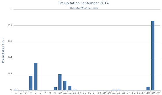
Thornton’s September this year was relatively benign and lacking much drama although it was a bit of a rollercoaster. Temperatures had their large swings and we saw a couple of days with healthy precipitation.
The month started out slightly cooler than normal on the first but then warmed over the next couple of days to a high of 93.8 degrees on the third.
Low pressure and a cold front brought an end to the heat and three days of cooler than normal temperatures arrived. Two of those three days combined to deliver more than a half inch of precipitation.
Warmer and drier weather returned for a few days before a more potent cold front pushed in. The 11th and 12th of the month brought our coldest days of the month. Low temperatures became quite chilly dropping to below freezing on the morning of the 13th as the system moved out.
Some rain fell on those days and while Denver recorded a trace of snow on the morning of the 12th, none was seen in Thornton.
We then rebounded nicely with 10 of the next 11 days seeing high temperatures above 80 degrees, many of those in the mid to upper 80s.
Things cooled down for the last three days as a strong system moved through. We recorded a significant 0.86 inches of rain on the 29th.
Thornton’s overall average temperature for the month was 62.6 degrees. This was a bit below the long term Denver average of 63.4 degrees. Out at the airport, it was as usual warmer with an average of 64.8 degrees.
Temperatures ranged from a high of 93.8 degrees on the 3rd down to a chilly low of 30.9 degrees on the 13th. Denver’s warmest day matched ours on the 3rd with a reading of 94 degrees while the Mile High City’s coldest reading of 33 degrees came on the 12th.
Denver saw one temperature record during the month. The record high minimum for September 25th was set with a reading of 56 degrees. This tied the record for the date last set in 1981.
In terms of precipitation, Thornton recorded 1.89 inches in the rain bucket for the month. Denver saw 1.79 inches. Both were well above Denver’s September average of 0.96 inches.
A daily rainfall record for Denver was set on the 29th when 1.01 inches fell at the airport. The old record of 0.96 inch for the date was set in 1959.
Thornton, Colorado’s September 2014 Temperature Summary. (ThorntonWeather.com)Thornton, Colorado’s September 2014 Precipitation Summary. (ThorntonWeather.com)
...THE DENVER CO CLIMATE SUMMARY FOR THE MONTH OF SEPTEMBER 2014...

CLIMATE NORMAL PERIOD 1981 TO 2010
CLIMATE RECORD PERIOD 1872 TO 2014

WEATHER         OBSERVED          NORMAL  DEPART  LAST YEAR`S
                 VALUE   DATE(S)  VALUE   FROM    VALUE  DATE(S)
                                          NORMAL
................................................................
TEMPERATURE (F)
RECORD
 HIGH              97   09/06/2013
                        09/05/2013
                        09/04/1995
 LOW               17   09/29/1985
HIGHEST            94   09/03        91       3       97  09/06
                                                          09/05
LOWEST             33   09/12        35      -2       38  09/28
AVG. MAXIMUM     78.9              78.5     0.4     78.6
AVG. MINIMUM     50.6              48.3     2.3     54.2
MEAN             64.8              63.4     1.4     66.4
DAYS MAX >= 90      2               3.4    -1.4        7
DAYS MAX <= 32      0               0.0     0.0        0
DAYS MIN <= 32      0               0.8    -0.8        0
DAYS MIN <= 0       0               0.0     0.0        0
PRECIPITATION (INCHES)
RECORD
  MAXIMUM         5.61   2013
  MINIMUM            T   1892                         1944
TOTALS           1.79              0.96    0.83     5.61
DAILY AVG.       0.06              0.03    0.03     0.19
DAYS >= .01         9               6.5     2.5       10
DAYS >= .10         4               3.3     0.7       10
DAYS >= .50         1               0.6     0.4        3
DAYS >= 1.00        1               0.1     0.9        2
GREATEST
 24 HR. TOTAL    1.01   09/29 TO 09/29           09/14 TO 09/15

SNOWFALL (INCHES)
RECORDS
 TOTAL             17.2   1991
TOTALS              T               1.3     -1.3       0

DEGREE_DAYS
HEATING TOTAL      91               125     -34       83
 SINCE 7/1         98               141     -43       83
COOLING TOTAL      88                76      12      133
 SINCE 1/1        701               764     -63      999

FREEZE DATES
RECORD
 EARLIEST     09/08/1962
 LATEST       06/08/2007
EARLIEST                        10/07
LATEST                          05/05
.....................................................

WIND (MPH)
AVERAGE WIND SPEED              9.4
RESULTANT WIND SPEED/DIRECTION   3/186
HIGHEST WIND SPEED/DIRECTION    33/350    DATE  09/09
HIGHEST GUST SPEED/DIRECTION    40/360    DATE  09/09

SKY COVER
POSSIBLE SUNSHINE (PERCENT)   MM
AVERAGE SKY COVER           0.50
NUMBER OF DAYS FAIR           13
NUMBER OF DAYS PC             11
NUMBER OF DAYS CLOUDY          6

AVERAGE RH (PERCENT)     55

WEATHER CONDITIONS. NUMBER OF DAYS WITH
THUNDERSTORM              3     MIXED PRECIP               0
HEAVY RAIN                1     RAIN                       6
LIGHT RAIN                9     FREEZING RAIN              0
LT FREEZING RAIN          0     HAIL                       0
HEAVY SNOW                0     SNOW                       0
LIGHT SNOW                2     SLEET                      0
FOG                       9     FOG W/VIS <= 1/4 MILE      1
HAZE                      3

-  INDICATES NEGATIVE NUMBERS.
R  INDICATES RECORD WAS SET OR TIED.
MM INDICATES DATA IS MISSING.
T  INDICATES TRACE AMOUNT.
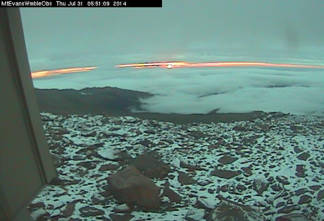
July 31, 2014 – Sunrise snow on Mount Evans. (DU Observatory)
With monsoonal moisture streaming into the state and cool air coming in from the north, Denver set its second weather record in as many days.
Denver’s official high temperature yesterday, July 30, as measured at DIA topped out at 62 degrees. This sets a new record low maximum for the date easily besting the previous mark of 64 degrees set in 2009.
The reading is more akin to what we expect to see in April and October and well below the average high temperature for the date of 90 degrees.
Here in Thornton we matched that reading with 62 degrees as well.
Ironically, Al Gore’s Climate Reality Project was in Denver the past two days for EPA hearings. The group pushed the theme “I’m too hot” while serving up ice cream from Ben & Jerry’s. Similar hearings were held in Washington DC and Atlanta and both cities saw below normal temperatures.
Perhaps not quite too hot, eh? It would appear the “Gore Effect” has proven itself again.
Late afternoon thunderstorms and showers began falling yesterday and continued through midnight. Areas to the east and north, including Denver International Airport, saw more precipitation than other locations and DIA set a daily rainfall record as a result.
Denver’s official rainfall total for July 29 came in at a healthy 1.80 inches. The previous 24 hour precipitation record for the date was 1.44 inches back in 1989. Precipitation records in Denver began in 1872.
Here in Thornton we recorded 0.82 inches for the date. While well short of Denver’s number, that is still a great deal of rain.
Stay up to date with the dynamic weather: Be sure to ‘like’ us on Facebook, follow us on Twitter and add us to your Google+ circles.
Weather, natural disasters & climate news and information.
 Our recent blast of Arctic air sent the mercury tumbling and in the process broke two daily records for December 30th.
 With a record-tying high temperature reading today, Denver recorded its third high temperature record of October 2014.
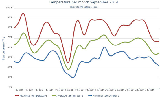
 Late afternoon thunderstorms and showers began falling yesterday and continued through midnight. Areas to the east and north, including Denver International Airport, saw more precipitation than other locations and DIA set a daily rainfall record as a result.