Tag Archives: NOAA

Solar flare headed to Earth; Expected to light up the sky in some parts of the nation

This X-ray photo of the Sun was taken by NASA's Solar Dynamics Observatory (SDO) on Sunday morning, August 1st.  The dark area near the top right edge is a filament of plasma being ejected, part of the coronal mass ejection (CME).  The bright region on the left half is an unrelated flare. (NASA)  Watch video of the ejection at the link below.
This X-ray photo of the Sun was taken by NASA's Solar Dynamics Observatory (SDO) on Sunday morning, August 1st. The dark area near the top right edge is a filament of plasma being ejected, part of the coronal mass ejection (CME). The bright region on the left half is an unrelated flare. (NASA) Watch video of the ejection at the link below.

A large solar flare on Sunday is expected to strike the Earth tonight treating sky watchers in the northern United States to a display of aurorae. The increased activity is being monitored by NOAA’s Space Weather Prediction Center (SWPC) in Boulder.

The ejection of charged particles from the sun follows a period of relative calm in terms of solar activity. What is being termed a “solar tsunami” – a wall of charged ion particles – is expected to trigger a geomagnetic storm visible in the northern latitudes.

The aurorae, normally only visible at extreme northern latitudes, are expected to put on a show for areas as far south as the northern contiguous United States the nights of August 3rd and 4th. 

Unfortunately for those in Colorado, the phenomena won’t be strong enough to reach the state. But, those in Oregon, Montana, North Dakota and other states further north should be able to witness the event.

You can get the rest of this story including seeing some amazing video of the eruption on the Denver Weather Examiner.
There's more to this story on Examiner.com!

City of Thornton discusses weather warning systems

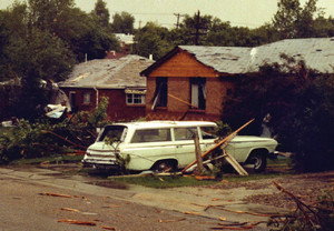
On June 3, 1981, Thornton was the site of the most destructive tornado in the history of the Denver metro area.  The City of Thornton is now evaluating options to warn residents of severe weather threats. (City of Thornton archives)
On June 3, 1981, Thornton was the site of the most destructive tornado in the history of the Denver metro area. The City of Thornton is now evaluating options to warn residents of severe weather threats. (City of Thornton archives)

Twenty nine years ago, the city of Thornton was struck by what was the most destructive tornado to hit the Denver metro area in history – a record which stands to this day.  Now, the City of Thornton has started to investigate options to alert residents when severe weather is set to strike. 

Visitors to ThorntonWeather.com have often asked us if the city was taking any steps to protect its citizens and warn them about severe weather.  The city – and Adams County – are lacking any type of alert system.  Following last year’s ‘Summer of Storms,’ we were told the city would look into it

Current options for citizens range from the Emergency Alert System used by television and radio broadcasters, free and pay Internet services as well as NOAA Weather Radio All Hazards (weather radio).  As we have discussed previously, these systems have their limitations. 

At this week’s city council update session, the Thornton City Council heard a presentation from city staff on the alternatives available.  Utilizing Reverse 911 and contracting with a third party provider were two of the items discussed. 

  • Read the presentation city staff gave to the Thornton City Council below

In trying to identify ways to keep citizens aware of deteriorating weather conditions, city staff told council, “Technology is changing so quickly that supporting a single system would not be efficient.” 

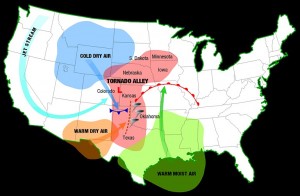
The Denver area is at the western edge of Tornado Alley and as we have seen historically and in recent days, the danger is real. Click image for larger view. Image courtesy NOAA.

Rather than implement their own system, staff recommended the city rely upon the federal government and the Federal Emergency Management Agency’s (FEMA) forthcoming Integrated Public Alert and Warning System (IPAWS)

Slated for widespread deployment in 2010, IPAWS will take the old Emergency Alert System and move it into the modern age by leveraging new communication technologies such as email and cellular phones. 

Mayor Erik Hansen told ThorntonWeather.com, “The City of Thornton recognizes the dangers of severe weather and we are actively working to identify solutions to protect its citizens.”

While the city waits for IPAWS, staff said they recommend the “development of a Weather Awareness Public Education Program that would be implemented in the spring of each year.”  They further would work to encourage residents to purchase weather radios. 

ThorntonWeather.com’s Take

We are pleased that the city is finally taking some steps in the right direction – albeit 29 years late. 

NOAA Weather Radio All Hazards is essential to protecting you and your family.

Their recommendation that residents purchase NOAA Weather Radio All Hazards is certainly a sound one.  As we wrote recently, these should be every citizen’s first line of defense against severe weather

The implementation of a severe weather education program is also a step in the right direction, assuming it takes the form of something more substantial than the simple brochure the city developed this year

Each spring the National Weather Service (NWS) offers storm spotter training seminars.  These would likely be overkill for average citizens however we think it would be ideal for the City of Thornton to partner with the Denver / Boulder NWS office to offer education sessions for citizens.  These could be taped and then shown on Channel 8 and on the city’s website.   

We do have our reservations about waiting for and relying on the forthcoming IPAWS system when commercial systems are available, proven and ready now for the city to implement.  Big government projects rarely are completed on time and often do not perform as expected.  Hopes are high for IPAWS but we are cautious on giving it any sort of endorsement. 

Granted, severe weather on par with the 1981 tornado is rare however last year’s severe weather and the Windsor tornado of two years ago show the danger is present.  If a warning system saves one life, the cost incurred is well worth it and we hope the city continues to stay on top of this issue – we will certainly be watching.

Related:

June 8, 2010 – City of Thornton City Council Update on Emergency Weather Warning Options

Weather radios – Your first line of defense against extreme weather

What is the best way to get information about severe weather?  A weather radio. (File photo)
What is the best way to get information about severe weather? A weather radio. (File photo)

No matter whether it is a blizzard in the winter or tornadoes and hail in the summer, it is important that everyone knows where to turn for information about developing weather conditions.  Keeping an eye on the sky is fine but oftentimes there is dangerous weather brewing that you may not see.

How dangerous is the weather?  Consider this:  In 2008, 566 people across the United States were killed by weather-related causes and 2,899 were injured – and that was a below average year.  Of those, 12 were Coloradoans that were killed with 100 Coloradoans injured.  Over $29 billion was paid out in property and crop losses across the nation, $166 million in Colorado alone.

The danger is real and with the severe weather we have seen recently, residents are wondering how best to keep themselves and their families safe.  Tuning in the TV or radio or checking your favorite weather website is one way but what if you aren’t near your computer or don’t have your TV on?  What if severe weather strikes in the middle of the night?

NOAA All Hazards Weather RadioIt is important to note that there is only one official source for weather related alerts and warnings – the National Weather Service (NWS).  All watches, warnings and alerts you see and hear about originate with the NWS and by far the best way to be proactively warned of severe weather is what is commonly referred to as a “weather radio.”

NOAA Weather Radio All Hazards (NWR) is a nationwide network of radio stations broadcasting continuous weather information directly from the nearest National Weather Service office. NWR broadcasts official Weather Service warnings, watches, forecasts and other hazard information 24 hours a day, 7 days a week.  When a weather watch or warning is issued, it is immediately broadcast on NWR.  The system is also used to broadcast information about other civil and weather hazard information like earthquakes, avalanches, chemical spills, terrorist attacks and even AMBER alerts.

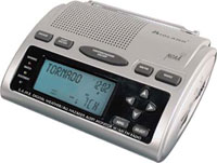
This weather radio from Midland (model WR-300) includes SAME area encoding and an AM / FM radio.

It is highly recommended that any weather radio purchased include the SAME feature – Specific Area Message Encoding.  Using the SAME feature, users can program a code into the radio for the area in which they live and the radio can then be set to automatically turn on and sound an alert when a weather watch or warning is issued for their area.  Users of weather radios with SAME coding can be assured they will be immediately notified in an emergency.

Price and features of weather radios can vary but a good one with the SAME feature can be found for about $30.00.  More expensive models may add clock, AM/FM radio and even weather forecasts retrieved from the Internet.  There are portable handheld models as well that you can take with you wherever you go.

Finding a weather radio locally may be difficult as there aren’t many stores that carry them.  Some Denver area King Soopers and Radio Shack stores have had them so you may call your local store to check.  Alternatively, there are many good, trustworthy sites online where they can be purchased including Amazon.com, New Egg and Ambient Weather.

Weather radios provide essential information when severe weather is ready to strike.  With a small investment, these units are an essential tool to protecting you and your family.

Do you have questions about weather radios?  Post them in the comments section below and ThorntonWeather.com will answer them.

April 2010 goes down in books as the hottest globally

Combined global temperature anomalies for April 2010. (NOAA)According to data released by the National Oceanic and Atmospheric Administration (NOAA), the combined land and sea temperatures for last month were the warmest April temperatures on record. Individually, sea surface temperatures were the warmest for any April and surface temperatures were the third warmest.

Utilizing data from the National Climatic Data Center (NCDC), the agency reported that the combined temperature of 58.1°F (14.5°C) was 1.37°F (0.76°C) above the 20th century average of 56.7°F (13.7°C).
For the period from January to April, temperatures also were the warmest first quarter on record. NOAA said the combined temperature over the period was 56.0°F (13.3°C). That is 1.24°F (0.69°C) above the 20th century average.

Arctic sea ice, long considered a harbinger of global warming, was reported at 2.1 percent below average. NOAA conceded however that sea ice was at its highest April extent since 2001. As reported previously, Arctic sea ice has seen three consecutive years of increasing measurements.

In the United States, NOAA said that April featured above normal temperatures and below normal precipitation. Much of the eastern half of the nation experienced warmer than normal temperatures resulting in measurements 2.3°F above average and going down in the books as the 14th warmest April on record.

For more on the climate, global warming and manmade climate change be sure to visit the Climate Change Examiner. 

National Weather Service modifies hurricane scale

Hurricane Ike bears down onto the upper Texas coastline with category 2 wind speed of 110 mph, September, 2008. (NOAA)

Beginning this hurricane season, NOAA’s National Weather Service will use a revamped hurricane rating system that does away with storm surge effects of each category. The new scale, called the Saffir-Simpson Hurricane Wind Scale will use wind as its only determining factor.

Herbert Saffir and Robert Simpson developed the original Saffir-Simpson Hurricane Scale as a way to communicate the threat of hurricanes based on their power and released it to the public in 1973. In addition to wind, the scale used storm surge as a factor when determining a storm’s category rating.

Since then, scientists have realized that the amount of storm surge generated by a hurricane can vary greatly, well outside the wind guidelines of the original scale. According to NOAA, the storm intensity, size, pressure and the underwater topography near where a hurricane is going to make landfall make a large difference.

In announcing the new scale, NOAA pointed two recent storms to convey the problem with the old scale. Hurricane Ike made landfall along the Texas coast in 2008. While only a Category 2 storm, it produced storm surge of 15 to 20 feet. By contrast, Hurricane Charley in 2004 was a Category 4 storm that struck Florida but only generated a 6 to 7 foot storm surge.

Storm surge is extremely dangerous and flooding resulting from it and the tremendous rains generated by hurricanes claim more lives than wind. As such, storm surge forecasts will continue however they will be independent of the hurricane ratings. Beginning this year, when discussing surge, it will be expressed in height above ground level to help residents understand the potential for flooding in their area.

The revamped scale also was accompanied by new descriptions of wind impact while retaining the same wind speeds that were previously used.

There's more to this story on Examiner.com!To view the new scale, a summary of what each of the categories means and examples of each, please visit the Natural Disasters Examiner.

NOAA announces new climate change portal

NOAAs new Climate.Gov website is supposed to provide a single point-of-entry for NOAA’s climate information, data, products and services.  (NOAA)
NOAA's new Climate.Gov website is supposed to provide a 'single point-of-entry for NOAA’s climate information, data, products and services.' (NOAA)

The National Oceanic and Atmospheric Administration (NOAA) has announced its new ‘portal to climate information’ at the web address Climate.Gov. The site is to serve as a consolidated home to climate information from across all of NOAA’s various departments.  The site has potential but despite the announcement, some of the information on the site is already out of date.

The new site was announced yesterday by Commerce Secretary Gary Locke and NOAA Administrator Jane Lubchenco. Ironically, the Gore Effect seemed to be in full force as the major winter snowstorm that struck Washington D.C. forced the press conference to be held by telephone.

The NOAA Climate Service Portal will go hand in hand with the proposed NOAA Climate Service, a new branch of NOAA that officials want to become the one-stop-shop for climate information from the U.S. government. “We envision this climate portal as the first step toward making the wealth of climate information at NOAA available in one easy-to-use resource,” Lubchenco said.

  • An interactive “climate dashboard” that lets users see a range of constantly updating climate datasets (e.g., temperature, carbon dioxide concentration, and sea level) over adjustable time scales;
  • A new Web-based climate science magazine called ClimateWatch, featuring videos and articles of scientists discussing their recent climate research and topics that cannot be relayed in charts and graphs;
  • Explanations and exploration of data products available from NOAA and partner agencies, with direct links to the sources of the comprehensive datasets;
  • Educational resources for students and teachers, including lesson plans for the classroom and laboratory, educational games and interactive media; and
  • Easy-to-understand fact sheets and presentations for professionals and the public about climate science, research and climate impacts.

There's more to this story on Examiner.com!The site is a great looking one but there are some problems.  Read about that in the complete story on the Climate Change Examiner.

NOAA: Nighttime and winter tornadoes a real danger

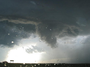
Tornadoes can and do strike at night and during winter months.  Are you prepared?
Tornadoes can and do strike at night and during winter months. Are you prepared?

Tornadoes are one of nature’s most violent storms. Able to strike without warning, they bring death and destruction with frightening frequency. Twisters can be scary enough to just think about and when you consider one striking at night when you can’t see it and aren’t expecting it, the odds of survival diminish.

Over the last three years, there has been an average of 1297 tornadoes per year and on average 91 tornado-related deaths per year. While not as common during the winter months, tornadoes can and do occur every month of the year and they do strike at night.

Seeking to draw attention to the dangers nighttime tornadoes present, the National Oceanic and Atmospheric Administration (NOAA) and its National Weather Service announced an effort to increase awareness. In a press release today, the services said that with the El Niño conditions we are experiencing, Florida and the Gulf Coast region stand a greater risk of tornadoes.

NOAA reminded all residents of the United States that a NOAA All Hazards Radio is the first line in defense against not only tornadoes, but all natural disasters. Also announced were new severe weather outlooks that will be issued when conditions are favorable for such storms.

There's more to this story on the Denver Weather Examiner's site!Get all the details from the Natural Disasters Examiner about what the National Weather Service said and learn what steps you can take to protect you and your loved ones.

Denver gets new National Weather Service weather station near downtown

Denver now as an official weather monitoring station closer to downtown but some say this doesnt solve the problem of the citys climate records being altered. (Examiner.com)
Denver now as an official weather monitoring station closer to downtown but some say this doesn't solve the problem of the city's climate records being altered. (Examiner.com)

It only took 14 years but Denver finally has an official monitoring station near downtown again. The new station amongst the greens of City Park Golf Course finally gives residents of Denver a place to see what the weather is doing closer to home.

With the opening of Denver International Airport in 1995, the National Weather Service moved its station to the new airport. That distance of 12 miles from the old Stapleton facility to DIA confounded citizens, television meteorologists and weather enthusiasts as they all noted that no one lives out at the airport and the conditions reported there do not reflect what is happening closer to town.

Recognizing the problem, a public-private partnership came together to do what they could to rectify the problem. The City and County of Denver, the Denver Museum of Nature and Science, the National Weather Service and NOAA, 7News Chief Meteorologist Mike Nelson and Colorado State Climatologist Nolan Doesken identified a site for the new station.

Eclar Fence and Mercury Electric donated the infrastructure for the new site. Weather equipment manufacturer Vaisala donated the weather monitoring hardware and services, estimated at up to $60,000.

Certainly there is little doubt the new station will provide area residents the ability to view conditions closer to where they actually live. The new station will not however address the very real problem of Denver’s climate records having been altered since the move to DIA. The National Weather Service has said the official records for Denver will still come out of DIA and as such many believe those records come with an asterisk.

There's more to this story on the Denver Weather Examiner's site!Why is there still a problem with Denver’s climate records?  What does the new station look like?  Check out the complete story including photos of the station, an interactive map and more on Examiner.com.

National Weather Service weather balloon zaps Thornton boy

Hundreds of weather balloons like this are released daily by the National Weather Service. (NOAA)

A 12-year-old boy reportedly received a bit of a shock when he touched a National Weather Service balloon that had landed near Niver Creek Middle School in Thornton. The balloons which are launched twice daily from the old Stapleton International Airport facility and other locations across the nation are essential instruments for forecasters.

The boy complained of numbness in his hands after touching it and school officials called the fire department as they were unsure what the device was. Upon closer inspection they read the labels that said the unit belonged to the National Weather Service and was a weather instrument. The boy was transported to a hospital as a precaution and his father told Channel 7 Wednesday morning that he was fine.

Weather balloons are launched daily from 102 locations across the United States, Caribbean and Pacific and are essential forecasting instruments (see below for a map of sites in the contiguous United States). The six foot diameter balloons are launched twice daily and simultaneously at all the sites at midnight UTC and noon UTC (5:00am MDT and 5:00pm MDT). Once launched, the units can attain an altitude of 115,000 feet and travel up to 200 miles before they burst and fall harmlessly to the ground.

Called a radiosonde, the balloon’s payload measures air pressure, temperature, humidity, wind direction and wind speed. The data is transmitted in real time to receivers on the ground which is then fed into National Weather Service computers and monitored by forecasters. Information obtained by the units is essential for forecasters to evaluate and predict atmospheric conditions for forecasting, severe weather alerting and more.

For more details on what these instruments are used for, read the full story on Examiner.com.

There's more to this story on the Denver Weather Examiner's site!

NOAA: Summer 2009 was 34th coolest on record; thousands of low temp records set

Highlighting the cooler summer, thousands of record low temperatures were experienced in July 2009. (NCDC)

The National Oceanic and Atmospheric Administration (NOAA) announced this week that the summer of 2009 was the 34th coolest since 1895. Covering the months from June to August for the contiguous United States, the average temperature was 0.4 degrees below the 20th century average.

Emphasizing the lower temperatures experienced in the United States over the summer, a closer look at the statistics provides some telling information.

Over the three month period, stations reporting to the National Climatic Data Center (NCDC) showed 2,254 daily record low temperatures and 1,296 low temperature records were tied according to preliminary data. Similarly, 4,051 daily record low maximums were recorded and 1,501 records were tied across the nation during the summer.

July in particular was notably cooler than normal and the single month by itself counted for roughly half of the records set across the three month summer. For the month, 2,212 record low maximum temperatures were recorded and 737 were tied. 1,225 new record low temperatures were recorded and 657 records were tied.

There's more to this story on the Denver Weather Examiner's site!For all the details on the United States’ summer weather including NOAA’s summary and a look back at the country’s August weather, go to Examiner.com.