Mother Nature seems to have a grudge against the City of Thornton’s annual spring festival. With thunderstorms arriving tonight and heavy rain expected through Saturday, most of the events have been cancelled.
May 13 to May 19: This week in Denver weather history
As we get further into spring the chances for severe weather increase greatly across northeastern Colorado and that is seen in our look back at this week in Denver weather history. We also note the dangers this weather presents as we see events where the weather injured and even killed Coloradans.
From the National Weather Service:
12-13
In 1907…the temperature warmed to a high of 73 degrees on the 12th…before a cold front produced a thunderstorm… Northeast winds sustained to 40 mph…and rain changing to light snow overnight. Snowfall totaled only 2 inches…but the high temperature on the 13th was only 39 degrees.
In 1961…a storm that covered metro Denver with rain and snow started as thunderstorms on the evening of the 12th. Hail to 1 1/2 inches in diameter was reported 10 miles northwest of Stapleton Airport. Rain continued overnight and changed to snow on the 13th. Snowfall totaled 6.4 inches and precipitation (rain and melted snow) 1.96 inches at Stapleton Airport where north winds gusted to 39 mph. The rain and heavy wet snow caused icing damage to utility lines. Heavy snow occurred in the foothills.
In 1982…a major storm dumped 1.50 to 3.50 inches of rain across northeast Colorado and deposited prodigious amounts of snow in the foothills. Coal Creek Canyon southwest of Boulder was buried under 46 inches of snow with 39 inches at Nederland. The heavy wet snow downed many power lines in the foothills. In Thornton…the roof of a school was damaged by water from the heavy rain. At Stapleton International Airport…1.49 inches of rain were measured over the two day period. The heavy rain ended a severe and prolonged drought.
In 2004…a winter storm produced heavy snow in excess of a foot in the foothills above 6 thousand feet while heavy rain fell across the city. The heaviest snow occurred in the high country of Boulder County. Storm total snowfall was 14.5 inches near Jamestown. Rainfall totaled 0.81 inch at Denver International Airport with 0.94 inch recorded at Denver Stapleton. A trace of snow was recorded at both locations. East winds gusted to 24 mph at Denver International Airport on the 12th.
13
In 1905…a thunderstorm produced hail during the late afternoon. Precipitation totaled 0.57 inch.
13-14
In 1912…heavy snowfall totaled 12.4 inches over the city. Most of the snow…9.9 inches…fell on the 13th…which was the greatest 24 hour snowfall in May at the time. This was the last snowfall of the season. The low temperature dipped to 27 degrees on the morning of the 14th.
In 1989…a spring storm brought heavy rain and snow to the foothills. Metro Denver was soaked with 1 to 2 inches of rain. Rainfall totaled 1.26 inches at Stapleton International Airport. In the foothills…Echo Lake received 20 inches of snow. A 30-ton Boulder slid onto I-70 east of the Eisenhower Tunnel…closing the freeway for 2 hours.
14
In 1910…a thunderstorm produced strong winds during the afternoon. Northwest winds were sustained to 42 mph.
In 1913…light moist snow and light hail fell during short intervals…although no thunder was heard. The trace of snowfall was the only snow of the month. Precipitation… Mostly rain…totaled 0.44 inch.
In 1984…a pilot reported a tornado 16 miles east of Stapleton International Airport. No damage was reported. A thunderstorm produced a 58 mph wind gust in Brighton. Thunderstorm winds gusted to 48 mph at Stapleton International Airport.
In 1989…lightning struck a home in Evergreen…setting it afire.
In 1992…strong thunderstorm winds of unknown velocity… Knocked over and damaged the infield tote board at Arapahoe Park Racetrack just southeast of Aurora. Damage was estimated at 200 thousand dollars. No injuries were reported. Lightning started two house fires…causing 35 hundred dollars in damage in Adams County just 9 miles north-northwest of Denver.
In 1994…a sudden wind gust…estimated at 40 mph…blew a portion of the roof off a shopping center in Lafayette. The roof also damaged two parked cars in an adjacent lot.
In 2001…a construction worker in Castle Rock received minor injuries when lightning struck close-by.
In 2002…a microburst wind gust to 53 mph was recorded at Denver International Airport.
In 2007…severe thunderstorms producing large hail…very heavy rain…and tornadoes impacted the urban corridor and adjacent plains. Heavy rain associated with a severe thunderstorm caused flooding along a small tributary draining into the South Platte River. The incident took place at 13th and Decatur St….near Invesco Field. The floodwaters inundated the bike trail adjacent to the creek. A woman with her child sought refuge under a bridge and became trapped by the high water. The woman slipped and the stroller containing the child was swept into the swift current. The child drowned. Rainfall totaled 0.42 inches at Denver International Airport. Elsewhere…golf ball hail was reported near Hudson. Hail…up to one inch in diameter…was observed in Boulder and Lyons. Thunderstorm wind gusts estimated to 70 mph were reported near Buckley Air Force Base…with a peak wind gust to 37 mph observed at Denver International Airport. A small tornado touched down near Ft. Lupton but did no damage.
14-15
In 1977…high winds up to 100 mph felled hundreds of trees in Gilpin County and caused extensive damage to telephone and power lines. Lumber and steel tanks were blown around in Boulder canyon. West winds gusted to 46 mph at Stapleton International Airport on the 15th.
14-18
In 1996…a period of unusually warm weather resulted in 4 record maximum temperatures in 5 days. The record high temperatures were 87 degrees on the 14th…89 degrees on the 15th…and 93 degrees on both the 16th and 18th. The temperature climbed to only 81 degrees on the 17th which was not a record.
15
In 1894…southwest winds were sustained to 38 mph with gusts to 50 mph.
In 1910…an apparent cold front produced sustained northeast winds to 48 mph.
In 1986…a thunderstorm dumped an inch of rain in an hour over the eastern part of Aurora. Total rainfall from the storm was 1.62 inches.
In 1989…a 47 year old man…a Lakewood police officer…was struck and injured by lightning. Small hail piled up 3 to 4 inches deep near Golden. There was reported street flooding from heavy thunderstorm rains over western metro Denver. Rainfall totaled 0.76 inch at Stapleton International Airport.
In 1990…a thunderstorm produced a wind gust to 69 mph at Jefferson County Airport in Broomfield. Thunderstorm winds gusting to 49 mph at Stapleton International Airport produced some blowing dust.
In 1991…a funnel cloud was sighted near Morrison. Later… Hail up to 2 inches deep covered U.S. Highway 285 at South Turkey Creek Road in west metro Denver. Baseball size hail was reported on the east side of Littleton. Dime size hail was reported in Boulder.
In 1993…lightning started a fire which damaged a home in Boulder. No one was injured.
In 1997…a wind gust to 58 mph was recorded at the site of the former Stapleton International Airport. A street sign was blown down at the Havana Street exit along I-70.
In 1999…lightning ignited a small fire in a 3-story structure in sunshine canyon above Boulder. The fire was quickly extinguished and caused only minor damage.
In 2003…thunderstorms produced very heavy rainfall and localized flash flooding in the foothills of central Boulder County. Rainfall ranged from 1.5 to 2.5 inches in less than 2 hours. Water ranging in depth from 6 to 9 inches covered State Highway 119 in Boulder Canyon. Dirt and rocks also washed over the roadway. Some basements were flooded in the sugarloaf area. Rockslides were also reported at Boulder falls…Lefthand Canyon…and Fourmile Canyon.
15-16
In 1957…heavy snowfall totaled 8.8 inches at Stapleton Airport. The greatest amount on the ground was 3 inches.
In 1986…a spring storm dumped 1 to 2 inches of rain over metro Denver…but 2.71 inches fell at Buckley Field in Aurora. Rainfall only totaled 0.84 inch at Stapleton International Airport. Snow fell in the foothills with 7 inches recorded in Coal Creek Canyon southwest of Boulder.
16
In 1875…a heavy hail storm turned into heavy rain during the afternoon. Rainfall totaled 0.86 inch in just 37 minutes…while the temperature dropped 22 degrees in 22 minutes. Precipitation totaled 0.90 inch.
In 1894…west winds were sustained to 48 mph with gusts to 56 mph.
In 1949…a tornado was observed for 16 minutes…20 miles to the southeast of Stapleton Airport. The tornado moved 5 miles to the northeast before dissipating. No damage was reported.
In 1963…intense lightning started several forest fires in the foothills southwest of Denver near Deckers and Cheeseman Lake. Little precipitation fell from the storms to alleviate the unusual dry conditions so early in the season.
In 1978…thunderstorm winds caused damage in southeast Aurora. Winds of 60 to 80 mph blew down numerous fences and damaged several homes under construction. High winds tore docks loose at Cheery Creek Reservoir…sinking 3 or 4 boats and damaging about 15 others. At Stapleton International Airport where winds gusted to 60 mph…a 727 jet suffered 15 hundred dollars damage when wind toppled a runway light onto it. The public reported an unconfirmed tornado 7 miles south-southwest of Stapleton International Airport.
In 1990…a line of thunderstorms moving across metro Denver uprooted a large ash tree…which fell and blocked the outside doors to a Denver elementary school…briefly trapping the students inside. Thunderstorm wind gusts to 69 mph were reported at Jefferson County Airport. Northwest winds gusted to 44 mph at Stapleton International Airport.
In 1991…two tornadoes touched down briefly in Castle Rock… But no injuries or damage were recorded. Heavy thunderstorm rains of 0.50 to 1.10 inches in a couple of hours caused Lena Gulch near Golden to flood. No damage was reported.
In 1996…dry microburst winds of unknown strength overturned a trailer and damaged storage sheds in Strasburg east of Denver.
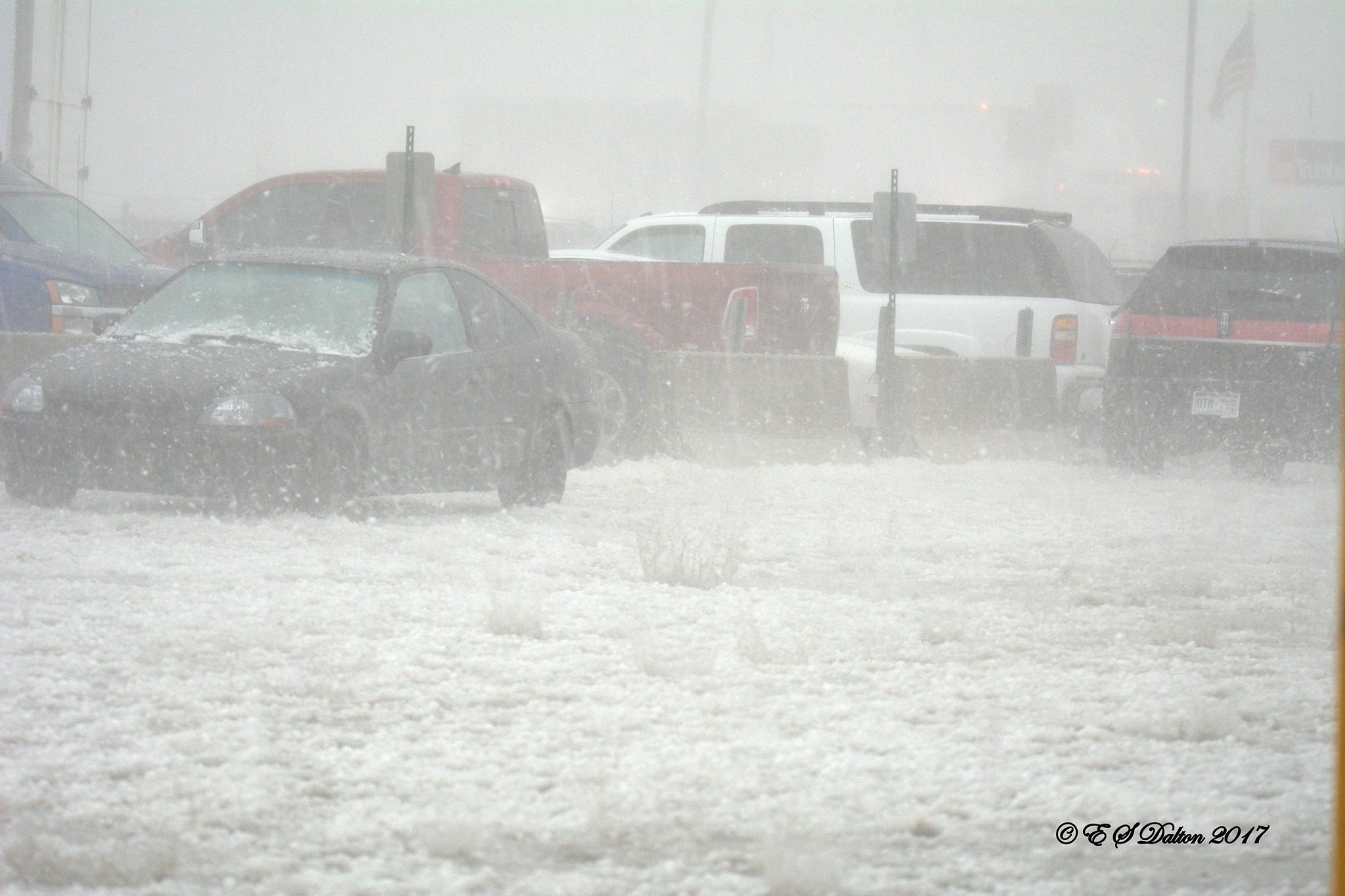
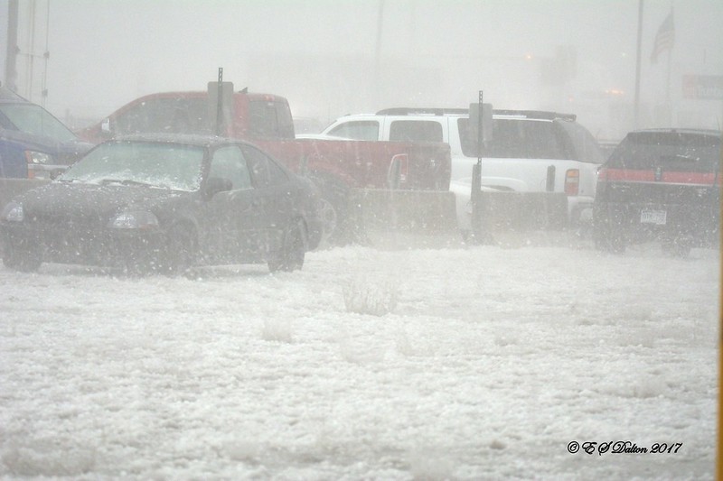
May 8, 2017 – Hail pounds an industrial area just northwest of downtown Denver. (Ed Dalton)
The weather forecast for May 8, 2017 was relatively typical for this time of year with pleasant temperatures and a sunny morning. We also wrote about the usual chance for PM thunderstorms but cautioned they could be potent saying, “Strong winds, large hail and possibly an isolated tornado will be possible.”
Little did we know just how potent they would be.
The thunderstorms that rolled through the Denver metro area that day brought monstrous hail, destroying windows, roofs, siding and vehicles.
As expected, the worst of the storms stayed south of Thornton but the areas that were hit from Golden to just north of downtown Denver were devastated. The tally to date is $2.3 billion in damage.
Fox 31 did a special on the storm last year and it makes for an interesting look back – and a reminder of the power of Mother Nature.
May 6 to May 12: This week in Denver weather history
Think we are done with snow for the season? That may be the case this year but it isn’t always so. Looking back at this week in Denver history we do see snowfall has occurred along with more typical spring weather including heavy rains that led to flooding.
From the National Weather Service:
4-8
In 1969…heavy rains caused flooding on Boulder creek in Boulder…which resulted in one death on the 7th. Flooding also occurred on Bear Creek in Sheridan and on the South Platte River in Denver. Rain over most of the eastern foothills started late on the 4th and continued with only brief interruptions in many areas until the morning of the 8th. Very high rates of rainfall occurred on the 6th and 7th with the greatest intensities in a band along the foothills from about 25 miles southwest of Denver northward to Estes Park. Storm totals by both official and unofficial measurements exceeded 10 inches over much of this area and were over 12 inches in some localities. Heavy snow fell in the higher mountains and in the foothills later in the period. The saturation of the soil resulted in numerous rock and land slides…and the heavy run-off caused severe damage along many streams and flooding on the South Platte River. Many foothill communities were isolated as highways were blocked and communications disrupted. Roads were severely damaged over a wide area…and a large number of bridges washed out. Many roads were closed due to the danger from falling rocks. A building in Georgetown collapsed from the weight of heavy wet snow. In Boulder…a man drowned when caught by the flooding waters of Boulder Creek…and a patrolman was injured. Rainfall totaled 7.60 inches in Boulder with 9.34 inches recorded at the Public Service Company electric plant in Boulder Canyon. In Morrison…rainfall totaled 11.27 inches in 4 days. Heavy rainfall totaled 4.68 inches at Stapleton International Airport over 3 days from the 5th through the 7th. Rainfall of 3.14 inches was recorded in 24 hours on the 6th and 7th. Downstream flooding continued along the South Platte River until the 12th when the flood crest reached the Nebraska line.
5-6
In 1907…rain changed to snow on the 5th…continued through the night…and totaled 3.50 inches. Northeast winds were sustained to 15 mph on the 5th.
In 1917…post-frontal rain changed to heavy snow and totaled 12.5 inches over downtown Denver. Most of the snow… 12.0 inches…fell on the 5th and this was the greatest 24-hour snowfall ever measured during the month of May. This was also the only measurable snow of the month that year. Low temperatures of 27 degrees on the 5th and 23 degrees on the 6th were record minimums for the dates. High temperatures on both days were in the lower 40’s. Southeast winds were sustained to 24 mph with an extreme velocity to 26 mph.
In 1964…high winds gusted to 54 mph in Boulder and to 80 mph at Jefferson County Airport near Broomfield. Wind gusts of 50 to 60 mph were common over all of eastern Colorado. Buildings…power lines…trees…and vehicles were damaged by the wind. South-southwest wind gusts to 54 mph caused some blowing dust at Stapleton International Airport where the visibility was briefly reduced to 2 miles.
In 1973…a heavy driving rain storm with embedded thunderstorms…produced 1 to 5 inches of rain and caused local flash flooding along the east slopes of the Front Range. The greatest flash flooding occurred in metro Denver where rainfall totaled 3.56 inches at Stapleton International Airport. Flooding in metro Denver occurred on clear creek and the South Platte River…already swollen from heavy snowmelt. Numerous basements were flooded… Roads and streets were washed out…a bridge was demolished… And miscellaneous other damage was reported. North winds gusted to 39 mph at Stapleton International Airport during the storm. The storm produced major downstream flooding along the South Platte River all the way to the Nebraska border during the next two weeks. One person died and total damage was estimated at around 120 million dollars.
In 1978…heavy wet snow of around 24 inches collapsed an office and hotel building in Boulder. Many cars were abandoned in the city. Denver received 14 inches of heavy wet snow with Evergreen and Golden reporting 12 inches. Snowfall totaled 12.4 inches at Stapleton International Airport with a total accumulation of snow on the ground of 8 inches due to melting. Southeast winds gusted to 23 mph on the 5th. Temperatures both days remained in the lower to mid 30’s.
6
In 1876…heavy snow fell during the night and ended during the morning…but no amount was recorded. Light hail fell briefly during the late afternoon. Precipitation for the day totaled 1.05 inch which would give an estimated snowfall of nearly 11 inches had all of the precipitation been snow.
In 1889…northwest winds were sustained to 45 mph in the city.
In 1893…heavy snow of 8.9 inches fell over downtown Denver. Once on the ground…the snow melted rapidly. This was the only snow of the month. Northwest winds were sustained to 20 mph.
In 1904…west winds were sustained to 45 mph with an extreme velocity to 46 mph.
In 1914…an apparent dry microburst produced sustained north winds to 44 mph with gusts as high as 50 mph.
In 1920…a thunderstorm produced hail and 0.55 inch of rain. The hail of unknown size covered the ground.
In 1921…thunderstorm winds were sustained to 42 mph with gusts to 44 mph. Rainfall was only 0.17 inch.
In 1936…a light to moderate duststorm moved in from the east on southeast winds and lasted most of the day. The dust reduced the visibility to two miles at times. Winds from the northwest sustained to 21 mph swept the dust out of the city during the late afternoon.
In 1966…a funnel cloud was sighted for 7 minutes to the southwest of Stapleton International Airport. The funnel appeared to be picking up dust from the ground…but was too distant to tell. No damage was reported.
In 1968…a thunderstorm wind gust to 53 mph was recorded at Stapleton International Airport.
In 1988…high winds raked the state. Wind gusts ranged from 60 to 80 mph in Boulder…Aurora…and at centennial airport. South-southwest winds to 53 mph were recorded at Stapleton International Airport. Across metro Denver…the strong winds knocked windows out of buildings…downed power poles and wires and some fences…unroofed several buildings…and damaged signs.
In 1997…strong winds from a dry microburst blew an empty 18-wheeler on its side in the northbound lane of I-25 north of Denver near the Brighton exit. There were no injuries. West winds gusted to 46 mph at Denver International Airport.
6-7
In 1873…snowfall totaled 8.9 inches in downtown Denver. Most of the snow fell on the 6th.
7
In 1904…west winds were sustained to 48 mph with gusts to 60 mph. A shower produced 0.16 inch of rain.
In 1953…a microburst caused a brief wind gust to 58 mph at Stapleton Airport.
In 1958…3/4 inch diameter hail fell over south metro Denver… 10 miles southwest of Stapleton Airport.
In 1977…baseball size hail damaged windows in Wheat Ridge. Hail was 4 inches deep on the ground in Arvada. Hail 3/4 to 1 inch diameter fell in Westminster and Kittredge.
In 1990…a fast moving cold front produced wind gusts of 40 to 60 mph. Brighton reported a wind gust to 57 mph…while north wind gusts to 44 mph were measured at Stapleton International Airport.
In 1995…severe thunderstorms struck Aurora. Hail piled 4 to 5 inches deep in the vicinity of Quincy Reservoir in south Aurora. Lightning struck an Aurora police communications tower causing significant malfunction to the primary system. Minor damage was sustained when lightning struck an apartment building. Hail…up to 1 1/4 inches in diameter…while soft and slushy…accumulated up to 6 inches deep in 15 minutes. Many streets were closed for an hour or more due to flooding caused by heavy rain and melting hail stones. Some trees were stripped of their leaves. Hail as large as 1/2 inch diameter was measured at Denver International Airport where a funnel cloud was sighted.
In 2003…a tornado touched down briefly near Bennett…but did no reported damage.
In 2005…severe thunderstorms produced 3/4 inch hail near Brighton and a thunderstorm wind gust to 60 mph near Fort Lupton.
In 2014…Severe thunderstorms produced large hail, from 1 to 1 1/2 inches in diameter, across parts of Arvada, Broomfield, Dacono, Northglenn and Thornton.
7-8
In 1958…rainfall totaled 2.50 inches at Stapleton Airport.
8
In 1873…a very light rain fell until 5:00 am…when it turned into light snow and sleet and was accompanied by brisk northeast winds. The snow froze as it fell… Breaking the telegraph lines in many places. Precipitation totaled only 0.14 inch in the city.
In 1883…a severe rain and hailstorm struck the city. In 25 minutes the hail was 5 inches deep in the vicinity of the weather office in downtown Denver and reported as deep as 10 to 12 inches in other parts of the city. Gutters were blocked by the hail…and many cellars were flooded. Precipitation from the storm was 1.90 inches with the total for the day recorded at 2.02 inches. The size of the hail was not recorded.
In 1988…a wind gust to 68 mph was recorded at Echo Lake. Northwest winds gusted to 35 mph at Stapleton Airport.
In 1995…high winds of unknown strength blew a camper shell from the back of a pickup truck near Fort Lupton. North winds gusted to 49 mph at Denver International Airport.
In 1996…1 to 2 inch diameter hail was measured in Lochbuie northeast of Denver. Bean size hail fell in Brighton. The large hail fell from severe thunderstorms to the northeast of metro Denver.
In 2003…tornadoes touched down briefly near Brighton… Watkins…and Strasburg…but did no reported damage. Hail to 3/4 inch in diameter was measured near Hudson.
8-9
In 1957…intense heavy rain caused flash flooding on toll gate creek in Aurora where 3 people were killed in a car. Up to 4 inches of rain fell in 5 hours in the Toll Gate Creek basin. The rain also caused flash flooding on sand creek in Aurora and Denver. Rainfall totaled 3.29 inches at Stapleton Airport with most of the rain…2.34 inches… Occurring on the 9th.
April 29 to May 5: This week in Denver weather history
May can bring a variety of conditions from snow and cold to severe thunderstorms and flooding rains. Looking back at this week in Denver weather history we see where all of those events have made an appearance in our past.
From the National Weather Service:
28-29
In 1950…snowfall totaled 6.3 inches at Stapleton Airport…but only 3.5 inches over downtown Denver.
In 1960…heavy snow fell at Stapleton Airport where 8.6 inches of snow were measured. North winds gusted to 38 mph. Most of the snow…6.9 inches…fell on the 29th.
29
In 1898…apparent thunderstorm winds were sustained from the southwest to 58 mph with gusts to 66 mph.
In 1909…north winds were sustained to 44 mph behind an apparent cold front. These were the strongest measured winds of the month that year.
In 1962…heavy snowfall totaled 6.4 inches at Stapleton Airport where northeast winds gusted to only 17 mph. Snow fell all day…but the most on the ground was only 1 inch due to melting.
In 1991…two men were struck by lightning while golfing in cherry hills just south of Denver. The two received only minor burns. Shortly afterward…lightning struck a home in cherry hills village several times…leaving numerous holes in the roof. No injuries were reported.
In 1993…localized strong winds occurred at Jefferson County Airport near Broomfield where gusts to 63 mph were recorded. The strong winds were the result of a probable microburst.
In 2000…several severe thunderstorms producing large hail and destructive winds rumbled across northern metro Denver. Thunderstorm wind gusts reached 81 mph near Hudson with hail as large as 3/4 inch in diameter at Longmont. Several homes and vehicles sustained damage. The strong winds uprooted trees and downed utility poles…causing scattered outages. Lightning sparked a house fire in Boulder. The fire damaged a portion of the roof and a bedroom on the third floor. Thunderstorm winds gusted to 53 mph at Denver International Airport.
In 2003…lightning struck a chimney at a residence in Hiwan in Evergreen…sending stones flying as far as 150 feet. Electrical equipment in some nearby homes also failed. Damage to the residence…in addition to electrical equipment…was estimated at 100 thousand dollars. Severe thunderstorms produced large hail to 1 inch in diameter near Hudson and Sedalia and to 3/4 inch near Parker. Hail as large as 1 3/4 inches was measured 9 miles north of Sedalia.
In 2014…high winds occurred east of Interstate 25. Peak wind gusts included: 71 mph just north of Strasburg; 68 mph at Denver International Airport; 62 mph near Elizabeth; 58 mph at Front Range Airport in Watkins and 11 miles east of Parker.
29-30
In 1964…several weeks of dry weather and windy conditions across the Great Plains to the east caused noticeable suspended dust to invade metro Denver. At Stapleton International Airport east winds gusted to 28 mph and visibility was reduced to 5 miles.
In 1989…a late season snowstorm dropped 2 to 4 inches of snow across metro Denver with 6 to 12 inches in the foothills. Snowfall totaled 3.9 inches at Stapleton International Airport where northeast winds gusted to 23 mph and the greatest snow depth on the ground was 2 inches due to melting.
In 1991…a pacific storm dumped heavy wet snow across metro Denver. The foothills were hit the hardest where snowfall amounts ranged from 16 inches at Evergreen to 5 inches at Idaho Springs. Lower elevations of metro Denver received 5 to 9 inches of snowfall with 5 inches in Boulder and 7.0 inches at Stapleton International Airport where northeast winds gusted to 25 mph. The weight of the snow caused power lines to fall and tree limbs to snap…producing power outages in parts of Denver…Aurora…and Westminster.
In 1999…heavy snow fell overnight in the foothills above 7500 feet elevation. Snowfall totals included: 13 inches near Rollinsville…10 inches near Evergreen…8 inches at Blackhawk and Nederland…and 7 inches at Conifer. Only rain fell across the city with 2.13 inches recorded at Denver International Airport.
29-2
In 1954…a major storm dumped 10.1 inches of snowfall at Stapleton Airport. Most of the snow…7.5 inches…fell on the 29th and 30th. The maximum snow depth on the ground was 5 inches on the 30th due to melting. No strong winds accompanied the storm.
30
In 1896…northwest winds were sustained to 55 mph with gusts as high as 64 mph in the city.
In 1960…the minimum temperature dipped to 22 degrees at Stapleton Airport. The sub-freezing cold damaged fruit trees and some other crops in the area.
In 1967…west winds gusted to 51 mph at Stapleton International Airport. Winds were strong and gusty across all of metro Denver.
In 1972…hail 1/2 to 3/4 inches in diameter fell at Stapleton International Airport. Northwest winds gusted to 35 mph.
In 1980…a cold air funnel touched down several times near Louisville.
In 1983…mothball-size hail fell in Wheat Ridge.
In 1992…the all-time highest recorded temperature in April… 90 degrees…occurred. This is also the earliest 90 degree reading for the season. In addition…the temperature dipped to a low of only 56 degrees…setting a record high minimum for the date.
In 1995…hail…up to 3/4 inch in diameter…fell at Denver International Airport. The hail was soft…lasted for only 8 to 10 minutes…and caused no damage.
In 2002…drought conditions started to have an effect on greater metro Denver. April…normally the third snowiest month of the year in Denver averaging just over 9 inches of snow…ended with only a trace of snow…ranking the month… Along with previous Aprils…the 2nd least snowiest on record. The month ended with only 0.23 inch of liquid precipitation making the month the 3rd driest on record. Mountain snowpack was less than half of normal for this time of year. A statewide drought emergency was declared by the governor.
In 2003…a small tornado touched down 10 miles east of Hudson… But did no damage. Hail as large as 3/4 inch in diameter fell in Aurora near Cherry Creek.
In 2004…post-frontal upslope flow produced light snowfall across metro Denver. Snowfall was 4.0 inches at Denver Stapleton…while the temperature hovered in the lower 30’s all day. The high temperature was only 33 degrees…a record low maximum for the date. The low temperature of 30 degrees was not a record. North winds gusted to 20 mph at Denver International Airport.
Colorado’s famously highly variable weather seems to showcase itself during the month of May when a variety of weather conditions can be seen.
Winter-like temperatures and snow are possible as are mid-summer like temperatures or the more typical spring severe weather.
We begin May 2018 with cool, damp conditions to be followed by a string of mild, pleasant days. Long range forecasts lean toward we warmer than normal month and one with potentially higher than average precipitation.
The month can bring extremes. Snow is not entirely uncommon during the month, oftentimes causing damage to newly bloomed trees. More common however is severe weather, particularly in the latter half of the month. Thunderstorms become more frequent and their associated hazards – lightning, wind, hail and tornadoes – are usual visitors.
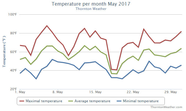
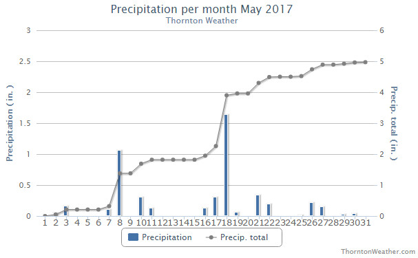
The month of May 2017 brought a wide variety of conditions. We experienced everything from summer-like temperatures to snow to severe weather with hail. In the end, average temperatures were below normal and precipitation more than double of average.
Between two systems at the start of the month, we began May with cool conditions and a bit of rain. Drier and very warm conditions then arrived on the 5th through the 7th before we cooled down to near normal levels for a couple of days.
On the 8th of the month, severe weather paid its first visit of the season unleashing heavy rain and most notably, large hail. While Thornton was spared the damage, areas to the south and west were pummeled with hail nearly 3 inches in diameter. The storm goes into the books as the costliest hail storm in Colorado history.
Weather conditions then settled down for the next 10 days with temperatures varying from cool to quite warm. On the 18th of the month, we then received a late season snowfall. Thornton recorded 1.9 inches snow and a healthy 1.64 inches liquid precipitation from snow melt and rain.
The balance of the month was much quieter. Some days saw light rain with temperatures not straying too far from average for the most part.
Thornton’s overall average temperature for the month was 55.5 degrees. This was a good ways below Denver’s long term average for the month of 57.1 degrees. Out at DIA where Denver’s official measurements are kept, it was slightly warmer with an average of 55.9 degrees.
Temperatures saw a wide range during the month. Thornton’s warmest reading was 87.8 degrees on the 6th of the month. Our coldest came in the wake of the snow on the 20th at 31.0 degrees. Denver saw its high of 86 degrees on the 6th as well and its low of 32 degrees on the 4th.
In terms of precipitation, Denver averages 2.12 inches during the month of May. Both Thornton and Denver easily exceeded those marks. Here in Thornton we recorded 4.84 inches of precipitation; in the Mile High City, 3.66 inches.
Snow in May is not unusual but getting it as late as we did is. On average Denver records 1.1 inches during the month. In May 2017, Thornton saw 1.9 inches. Out at the airport, a mere trace was recorded.
Hail pounds north Denver in our first severe weather of the season on May 8, 2017. (Ed Dalton)
Colorado’s famously highly variable weather seems to showcase itself during the month of May when a variety of weather conditions can be seen. This provides a prime opportunity for photos of everything weather to flora to fauna.
The month of May can bring extremes. Snow is not entirely uncommon during the month but more common is severe weather, particularly in the latter half of the month. Thunderstorms become more frequent and their associated hazards – lightning, wind, hail and tornadoes – are usual visitors. Providing additional subjects for pictures are the emerging spring flowers and our abundant wildlife.
Slideshow updated June 1, 2017. To learn more about how to send your photo to us for inclusion in the slideshow, see below the slideshow.
Showcasing images captured by ThorntonWeather.com readers as well as some of our own, our monthly slideshow covers the entire gamut of weather-related imagery.
Sunsets, sunrises, wildlife and of course every type of weather condition are vividly depicted in images captured from yours and our cameras.
[flickr_set id=”72157683626294335″]
What is missing in the slideshow above? Your photo!
Our monthly photo slideshow is going to feature images that we have taken but more importantly images that you have captured. The photos can be of anything even remotely weather-related.
Landscapes, current conditions, wildlife, pets, kids. Whimsical, newsy, artsy. Taken at the zoo, some other area attraction, a local park, a national park or your backyard. You name it, we want to see and share it!
Images can be taken in Thornton, Denver or anywhere across the extraordinary Centennial State. We’ll even take some from out of state if we can tie it to Colorado somehow.
We’ll keep the criteria very open to interpretation with just about any image eligible to be shown in our slideshows.
What do you win for having your image in our slideshow? We are just a ‘mom and pop’ outfit and make no money from our site so we really don’t have the means to provide prizes. However you will have our undying gratitude and the satisfaction that your images are shared on the most popular website in Thornton.
To share you images with us and get them included in the slideshow just email them to us or share them with ThorntonWeather.com on any of the various social media outlets. Links are provided below.
May 28 to June 3: This week in Denver weather history
There are many notable events on our look back at the weather history books for this week but one in particular stands out. It was 36 years ago this week, on June 3, that the infamous Thornton tornado struck. This twister still stands as the most damaging tornado to have ever struck the Denver metro area.
26-31
In 1995…a cool period with light morning showers and moderate to heavy afternoon showers and thunderstorms pushed rivers already swollen from mountain snow melt over their banks causing minor flooding. Streams and rivers such as the South Platte and Boulder creek flooded meadowlands…bike paths…roads near streams…and other low lying areas. No significant property damage was reported and crop damage was unknown. Rainfall totaled 1.79 inches at the site of the former Stapleton International Airport and only 1.51 inches at Denver International Airport.
28
In 1884…a thunderstorm apparently produced large hail. The hail stones were noted as unusually large…but the diameter of the stones was not measured. The hail fell for only 5 minutes. Precipitation from the storm was only 0.05 inch.
In 1898…heavy thunderstorm rainfall totaled 1.74 inches in downtown Denver. Hail of unknown size accompanied the storm.
In 1981…a woman in Aurora was struck and killed by lightning. Another bolt injured a boy on a bicycle at about the same time a short distance away. About half an inch of rain in 20 minutes caused street flooding in the area. A tornado touched down for about 2 minutes some 3 miles north of Stapleton International Airport.
In 1982…severe thunderstorms produced golf ball size hail in southeast Denver…Aurora…and Strasburg. The large hailstones undoubtedly damaged some cars in the area. At Stapleton International Airport…only 1/2 inch diameter hail was measured.
In 1991…golf ball size hail fell in Brighton. No damage was reported. Later…hail ranging in size from 3/4 inch to 1 1/2 inches in diameter fell over southwestern sections of metro Denver. In some areas…hail piled up a few inches in depth.
In 1994…thunderstorm wind gusts to 65 mph damaged 16 small airplanes and a hangar at centennial airport.
In 2001…severe thunderstorms produced large hail across metro Denver. Hail as large as 1 inch in diameter fell in Lakewood…Wheat Ridge…northwest Denver…near Watkins… Bennett…and Keenesburg. Hail 3/4 inch or larger fell in Brighton. Thunderstorm winds gusted to 58 mph at Denver International Airport. A small tornado (f0) touched down near Bennett…but did no damage.
29
In 1934…the low temperature dipped to only 66 degrees…the all-time record highest minimum temperature for the month of May.
In 1958…a microburst caused a brief wind gust to 56 mph at Stapleton Airport.
In 1964…heavy rain caused flooding in the Harvey Gulch area of southeast Denver. The high water damaged homes… Businesses…streets…and bridges. At Stapleton International Airport…1.33 inches of rain were measured with 1.76 inches total rainfall on the 29th and 30th. The heavy rain during the last week of the month was the first significant precipitation since April 3rd.
In 1967…3/4 to 1 inch diameter hail stones fell in the city of Denver…but caused no reported damage. Hail as large as 3/4 inch was measured at Stapleton International Airport.
In 1975…the heaviest last snowfall of the season occurred when 5.6 inches of snow were measured at Stapleton International Airport. Rain all day on the 28th changed to snow on the 29th and accumulated to a depth of 4 inches on the ground. Northwest winds gusted to 31 mph. Precipitation (rain and melted snow) on the 28th and 29th totaled 1.48 inches.
In 1982…one man was killed and two others injured by a lightning strike as they stood under a tree in the city of Denver’s Washington Park.
In 1987…7/8 inch diameter hail fell near Castle Rock.
In 1990…thunderstorms over metro Denver produced several small funnel clouds and two small tornadoes. The first tornado (f0) touched down in northwest Denver and caused roof damage to a house and snapped off the tops of several trees. A second tornado (f1) touched down in Northglenn and moved into Thornton damaging a group of self storage garages…several vehicles…a wooden fence…several trees… And the roof of an auto parts store. No injuries were reported. The storms also caused minor street flooding across northern and western sections of metro Denver. Rainfall totals ranged from 1 to 3 inches. Lightning started a small fire at a home in northwest Denver. The fire was confined to the front rooms and was quickly extinguished. Snow plows were used to clear 2 to 4 inches of pea to marble size hail from a stretch of U.S. Highway 285 in Turkey Creek Canyon. Lightning felled a tree in northeast Denver…while strong winds snapped off several large tree limbs in the same area. Thunderstorm rainfall totaled 0.82 inch at Stapleton International Airport where southwest winds gusted to 30 mph.
In 1991…lightning struck a 13 year old boy in a field in Fort Lupton. The boy was in critical condition in an area hospital for 2 days before recovering.
In 1995…lightning struck a soccer goal post and injured 6 adults viewing a soccer game in Arvada. Although no one received a direct hit from the lightning…all escaped with only minor injuries…except one woman who was hospitalized.
In 1996…large hail…3/4 to 1 1/2 inches in diameter… Struck Lakewood and west Denver. Lightning sparked a small fire when it struck an oil storage tank 5 miles west of Brighton.
In 2001…lightning sparked a fire in an apartment complex in Aurora…forcing the evacuation of 24 units. Most of the fire damage was confined to the attic. Damage was estimated at 100 thousand dollars.
In 2004…a man and his son were struck by lightning while practicing on the driving range at the Meadows Golf Club in southwest metro Denver. The father was killed by the bolt…and his 16 year old son seriously injured. Three other people standing nearby received only minor injuries.
In 2010…hail up to 7/8 inch in diameter was reported in Broomfield.
May 21 to May 27: This week in Denver weather history
If history is a teacher, our look back at this week in Denver weather history should provide great instruction on the dangers severe weather presents in our history. It was eight years ago this week that the infamous Windsor tornado tore through the area killing one man and damaging hundreds of homes.
From the National Weather Service:
20-21
In 1891…heavy rain was mixed with snow at times and totaled 2.02 inches in the city. Snowfall was 1.0 inch. Northeast winds gusted to 28 mph on the 20th.
20-22
In 1959…a three-day rain caused some flooding in metro Denver where rain totaled 1.68 inches at Stapleton Airport. Showers…accompanied by hail near Brighton…caused some damage to truck crops. Heavy snow in the foothills caused damage to power and telephone lines.
20-27
In 2002…lightning sparked a wildfire near Deckers. Extremely dry conditions and very strong winds the following day allowed the fire…known as the Schoonover…to consume 3850 acres before it could be contained. Thirteen structures were destroyed…including 4 homes…resulting in 2.2 million dollars in damage.
21
In 1874…an extensive fire at Central City in the mountains to the west of Denver produced large columns of smoke that were visible from the city. In the afternoon…the smoke and fire produced a dark inky black convective cloud…which spread over the city and produced brief strong and gusty winds along with a few sprinkles of rain.
In 1880…west winds increased to a sustained velocity of 40 mph during the afternoon.
In 1893…north winds were sustained to 48 mph.
In 1914…a severe thunderstorm was attended by hail…excessive rainfall which totaled 1.94 inches…and an unusual amount of vivid lightning. The heavy rainfall of 0.83 inch in 15 minutes produced flooding…which caused considerable damage to bottom lands in eastern and southern parts of the city. Many garden tracts and cellars were flooded. Southwest winds were sustained to 29 mph with gusts to 34 mph.
In 1935…no precipitation occurred…making this one of only two days without precipitation during the entire month. The other day was the 10th. Precipitation totaled 4.95 inches for the month.
In 1952…a tornado produced a high column of dust and dirt over northwest Denver. No damage was reported.
In 1988…a microburst wind gust to 52 mph was recorded at Stapleton International Airport.
In 2002…very strong winds occurred over metro Denver and northeastern Colorado as a developing surface low pressure center intensified. Trees and branches snapped…downing power lines across parts of metro Denver. About 20 thousand residents lost electricity. The strong winds produced much blowing dust and dirt especially to the northeast of metro Denver. Winds gusted to 61 mph at Parker. South winds gusted to 58 mph at Denver International Airport.
In 2006…a large dust devil formed near Quincy Reservoir in south Aurora. The tall column resembling a tornado or smoke plume extended upward into small high-based cumulus clouds and was visible for miles across southern Aurora and eastern centennial. No damage was reported.
In 2014…severe thunderstorms occurred in and around metro Denver. The storms produced large hail…from quarter to golfball size. Frontier Airlines canceled 16 flights…when several planes sustained hail damage. Forty flights at Denver International Airport were either delayed or canceled. Some homes in Green Valley Ranch…east of Denver… were damaged by hail. Several vehicles were also damaged. Five short lived tornadoes touched down near Bennett and Byers but no damage was reported. The storms also produced heavy rain and strong damaging winds. The wind downed trees and power lines east of Denver. The heavy rain and hail…up to 6 inches deep in spots…caused street flooding around the metro area. The hailstorm at Dicks Sporting Goods Park knocked out power to the stadium where the 4A and 5A girls soccer championship games were about to be played. The inclement weather snarled traffic on Interstate 70…Pena Boulevard… U.S. 85 and elsewhere due to the flooded roads. In some areas…snow plows were called out to clear the hail. Parts of Tower Road and Peoria Street…and other roads in Commerce City… were closed through the late evening hours…because of standing water. Several vehicles stalled in standing water where water pooled in the underpasses. At Denver International Airport…1.2 inches of water was observed…along with a wind gust to 42 mph from the northwest.
21-22
In 1878…overnight heavy rains of cloudburst intensity on the Palmer Divide to the south of the city caused flash flooding on Cherry Creek in Denver…which resulted in 2 deaths. A wall of water swept through the city between 2:00 am and 3:00 am on the morning of the 22nd. The flood was so sudden and unexpected that homes along the creek in the city were submerged in water knee deep before the slumbering occupants knew anything about it. By daybreak the banks on both sides of the creek were lined by residents viewing the destruction caused by the raging waters in such a short time. Seven bridges across the creek were destroyed in the city. Damage to private and city property was estimated between 30 and 50 thousand dollars. Quite a number of cattle and sheep were killed along the reach of the creek. Only 0.01 inch of rain fell in the city on the 21st with a trace of rain on the 22nd. Flash flooding also occurred on Kiowa Creek near Bennett on the night of the 21st when the flood waters washed out the Kansas Pacific Railroad bridge. An east bound freight train plunged into the turbulent waters killing the three crewmen. The locomotive was completely buried in the sand and never found to this day!
21-23
In 1876…snow changed to heavy rain over the city…resulting in widespread flooding along Cherry Creek and the South Platte River…nearly as great as the flash flood of May 19-20…1864. However…damage was greater because the city had grown much larger and there were more bridges for the flood waters to destroy. Precipitation in the city totaled 6.70 inches from 10:00 pm on the 21st through 3:00 am on the 23rd. The greatest precipitation ever recorded in Denver in 24 hours…6.53 inches…occurred on the 21st and 22nd. Small buildings and bridges along Cherry Creek were washed away by the flood waters. Bridges over the South Platte River were damaged. The city irrigation ditch was damaged and rendered unfit for service. Strong winds at speeds of 30 to 40 mph drove the heavy rain through brick walls 12 to 16 inches thick. Many sheep and cattle were either killed by lightning or drowned…including some 100 head of cattle in Jefferson County alone. There was immense damage to railroad tracks…especially the Kansas Pacific line to the east of the city. The Colorado central suffered estimated damage of 10 to 15 thousand dollars. In addition…the heavy rain caused extensive flooding on Soda and Bear Creeks in the foothills. Flooding along Boulder Creek inundated farm and pasture land in the Boulder Valley and damaged a few bridges. Rail travel had to be suspended in the area for several days.
22
In 1876…the most precipitation in Denver on any calendar day…6.50 inches…occurred.
In 1901…northeast winds were sustained to 41 mph with gusts to 45 mph.
In 1903…west winds were sustained to 45 mph with gusts to 55 mph from an apparent microburst…which produced a trace of rain.
In 1976…the public reported 3/4 inch diameter hail and wind gusts to 53 mph near Littleton.
In 1987…golf ball size hail fell in the Lorretto Heights area of south metro Denver.
In 1991…a tornado touched down briefly in Castle Rock. No injuries were reported.
In 1993…an off duty national weather service employee reported hail up to golf ball size just west of the city of Denver in Jefferson County. Thunderstorm wind gusts reached 58 mph at Jefferson County Airport near Broomfield and 33 mph at Stapleton International Airport.
In 1996…a severe thunderstorm pummeled northwest and northern sections of metro Denver with large hail ranging in size from 3/4 to 2 inches in diameter. The cities of Arvada and Westminster were the hardest hit. The insurance industry estimated 60 million dollars in damage to homes and personal property and 62 million dollars in damage to automobiles…for a total of 122 million dollars in insured losses. This estimate also included the cities of Golden… Thornton…and wheat ridge. This was the fourth worst hailstorm to hit metro Denver in the last 10 years.
In 1998…large hail fell across north metro Denver. Hail as large as 1 1/2 inches in diameter was measured in Broomfield and Hudson. Hail to 1 1/4 inches fell in Roggen. Hail to 1 inch fell in Brighton…near Keenesburg… In Watkins…and in the city of Denver. Lightning ignited a house fire in Ft. Lupton. A warehouse worker in Denver was injured when he was knocked off a loading dock by a lightning bolt. The bolt skipped off a nearby radio tower and struck him in the arm. He was treated for numbness in his right arm and released.
In 1999…severe thunderstorms produced 7/8 inch diameter hail over the city of Denver…with one inch diameter hail reported in Aurora…and 3/4 inch hail near Watkins.
In 2006…a lightning strike sparked a fire and damaged the roof of a recreation center in Evergreen. The fire spread into some brush and consumed about one quarter acre before it was extinguished. Severe thunderstorms produced strong wind gusts across portions of metro Denver. Winds gusted to 72 mph in Georgetown…62 mph near Parker and Bennett… 60 mph in Castle Rock…and 59 mph in Longmont. The winds caused no reportable damage. A thunderstorm produced southwest wind gusts to 52 mph at Denver International Airport.
In 2008…a powerful tornado swept north-northwestward across Weld County…carving a path of destruction nearly 39 miles in length. The tornado…up to one-mile wide at times… Initially touched down northeast of Platteville and finally lifted 6 miles west-northwest of wellington. A tornado assessment in the aftermath of the tornado revealed extensive areas of damage. On the Enhanced Fujita Scale… There were pockets of ef3 damage near the Missile Silo Park campground and to businesses and a home in eastern Windsor. Farmers reported extensive damage to crops and irrigation equipment. There was one fatality and 78 injuries… Ranging from broken bones to minor cuts and lacerations. One man was killed when he tried to escape a trailer park in his motor home. Tractor trailers were flipped along U.S. Highway 85…and over 200 power poles were snapped or blown down. Approximately 60000 people were left without electricity. The tornado overturned 15 railroad cars and destroyed a lumber car. The tornado also flattened the main feedlot in Windsor and destroyed a dairy barn. Most of the 400 cows were killed in the tornado or destroyed later. The thunderstorm also produced hail up to the size of baseballs. Another tornado from a separate thunderstorm… Rated an ef1…briefly touched down near Dacono and destroyed 5 buildings. The tornado overturned a five-wheel trailer and injured a man sitting inside. Preliminary estimates from FEMA indicated 850 homes were damaged…and nearly 300 homes were significantly damaged or destroyed. The Poudre Valley Rural Electric Associated reported $1 million of damage to electric transmission lines. Privately insured damages totaled $147 million…making it the state’s 4th costliest disaster. Large hail up to 1 1/2 inches in diameter…was reported in the vicinities of Golden and Longmont.
In 2014…a severe thunderstorm Denver area produced nickel to quarter size hail in parts of west Denver and near Bennett. Locally heavy rainfall produced some minor street flooding in parts of metro Denver. The heavy rainfall produced localized flash flooding near Bennett. Rainfall totaled 0.54 inches at Denver International Airport.
22-23
In 1933…high winds and gales overnight caused considerable damage in and near the city. Much greenhouse glass was broken…which caused damage to sheltered plants. Great numbers of plants growing in the open were damaged or killed by wind-driven sand and soil. Fields were eroded by the wind and a few trees were uprooted. West winds were sustained to 38 mph with gusts as high as 65 mph in downtown Denver on the 22nd.