 As Thornton gets hit by a much-needed snowstorm, we are monitoring it very closely and posting regularly to our Facebook page and Twitter feed.
For comprehensive look at the storm, please monitor our Winter Weather Briefing page.
As Thornton gets hit by a much-needed snowstorm, we are monitoring it very closely and posting regularly to our Facebook page and Twitter feed.
For comprehensive look at the storm, please monitor our Winter Weather Briefing page.

As we talked about in our March weather preview, Denver can see the entire gamut of weather conditions this time of year and our look back at this week in history shows that. There are of course plenty of the famous March snowstorms including big ones in 1992 and 1998. We also see the usual high winds such as was the case in 2000 and even extreme cold as we saw over an extended period in 1906.
6-7
In 1981…a storm dumped 4 to 8 inches of snow over higher elevations between Denver and Colorado springs. At Stapleton International Airport…north winds gusted to 16 mph and snowfall totaled only 2.5 inches.
In 1998…heavy snow fell over portions of metro Denver and the adjacent foothills. Snowfall totals included 11 inches at Chief Hosa…10 inches near Evergreen…8.5 inches in Broomfield…8 inches at Bailey…and 7 inches at both Standley Lake and Thornton. Elsewhere…snowfall across metro Denver ranged from 3 to 6 inches with 4.9 inches measured at the site of the former Stapleton International Airport. North winds gusted to 26 mph at Denver International Airport on the 7th. Several accidents occurred along area roads and highways when they became icy and snowpacked.
6-8
In 1932…snowfall totaled 6.3 inches in downtown Denver. Most of the snow…5.2 inches…fell on the 8th. Northeast winds gusted to 20 mph on the 6th.
7
In 1872…heavy rain started shortly after midnight and soon turned to sleet…which continued to just after sunrise…the ground at that time not even being white. At about 7:00 am the worst snow storm of the winter commenced and continued until 10:00 pm…snowing heavily nearly all the time. North winds averaged a sustained speed of 25 mph. About 8 inches of snow fell…but it drifted too much to obtain a direct measurement.
In 1901…northwest winds were sustained to 40 mph with gusts as high as 58 mph. The strong Chinook winds warmed the temperature to a high of 70 degrees.
In 1902…northwest winds were sustained to 45 mph with gusts to 53 mph.
In 1950…strong north winds at 40 mph with gusts as high as 60 mph produced a dust storm across metro Denver. At Stapleton Airport…blowing dust reduced visibility to as low as 1/4 mile for most of the day.
In 1972…northwest winds gusted to 51 mph at Stapleton International Airport. The Chinook winds warmed temperatures to a high of 64 degrees.
In 1984…a wind gust to 63 mph was recorded at Golden Gate Canyon west of Denver. West winds gusted to 39 mph at Stapleton International Airport.
7-8
In 1878…snow from the evening of the 7th until noon of the 8th totaled only 5 inches in downtown Denver. Apparent heavier snow over the plains along with strong winds drifted the snow into high drifts…which delayed trains for several days and caused a great loss of livestock. Melting of the snow caused a rise in Cherry Creek…which resulted in much damage. Precipitation from the storm totaled only 0.50 inch in Denver.
In 2000…high winds developed in and near the Front Range foothills…as well as parts of the northeast Colorado plains as another pacific storm system moved across the area. Several trees and power lines were downed near Blackhawk…Boulder…and in Coal Creek Canyon. About 30 homes in the Pinebrook Hills subdivision in Boulder were evacuated when downed power lines sparked a grassfire. The winds eventually shifted the fire onto itself…thus allowing firefighters to contain the two acre blaze. Several roofs were blown off barns…sheds… And garages. Two semi-trailers were blown over…one along c-470 between Golden and Morrison and another north of Denver on I-25. Wind gusts reached 101 mph on Rocky Flats…100 mph at the nearby national wind technology center…90 mph at Blackhawk and atop Blue Mountain…92 mph in south Boulder…73 mph in Coal Creek Canyon…72 mph in Golden…and 70 mph at Louisville. Northwest winds gusted to 45 mph on the 7th and to 49 mph on the 8th at Denver International Airport.
8
In 1878…winds started to increase at 4:00 am and blew steadily at sustained speeds of 36 to 40 mph with a maximum sustained speed of 60 mph around 11:00 am. Snowfall of 5.0 inches occurred in the city…but much more snow fell on the plains…which blockaded trains bound for the city for several days.
In 1898…northwest winds sustained to 53 mph with gusts to 60 mph warmed the temperature to a high of 67 degrees.
In 1908…light snowfall of 0.8 inch produced only 0.01 inch of precipitation. This along with the 0.10 inch of precipitation on the 21st resulted in the driest March on record with a total of 0.11 inch of precipitation.
In 1986…temperatures climbed from a record high minimum of 45 degrees to a record maximum of 72 degrees for the day.
In 2005…a vigorous cold front moved a wall of blowing dust across metro Denver during the mid-morning. At Denver International Airport…north winds sustained to 48 mph with gusts as high as 55 mph…along with very light rain which changed to snow…briefly reduced the surface visibility to 1 mile. A thunderstorm formed over Arvada. With the passage of the cold front…the temperature plunged 11 degrees in just 16 minutes at Denver International Airport where precipitation was only 0.01 inch along with 0.1 inch of snow.
8-9
In 1992…a major blizzard struck metro Denver. The storm was preceded by thunderstorms with small hail during the afternoon of the 8th. By evening…with the passage of a strong arctic cold front…snow began falling. Strong north to northeast winds at 30 to 40 mph with gusts to 52 mph produced near zero visibilities in blizzard conditions across metro Denver. By the morning of the 9th…snowfall amounts up to a foot and a half were reported with drifts of 2 to 4 feet. Many roads were closed including I-70 east of Denver and I-25 both north and south of Denver. Many homes and stores were temporarily without power. Snowfall amounts included: 18 inches at Conifer…13 inches in Boulder and Denver…12 inches at Brighton and Morrison…and 10 inches at Aurora. Snowfall totaled 12.4 inches at Stapleton International Airport where north winds gusting as high as 52 mph reduced the visibility to zero at times in heavy snow and blowing snow.
In 2002…high winds occurred in the foothills west of Denver. Winds gusted to 95 mph near Fritz Peak and to 73 mph near Nederland.
8-10
In 1989…unusually warm weather set four daily temperature records in Denver. The high temperature of 74 degrees on the 8th exceeded the record. Records were equaled on the 9th with a high of 77 degrees and the 10th with a high of 79 degrees. The low temperature of 42 degrees on the 10th set a new record high minimum for the date.
9
In 1918…northwest winds sustained to 44 mph with gusts as high as 52 mph occurred during the early morning hours.
In 1960…west-northwest winds gusted to 51 mph at Stapleton Airport.
In 1980…high winds were recorded in the foothills with a wind gust to 84 mph at Wondervu. Northwest winds gusted to 38 mph at Stapleton International Airport.
In 1982…strong Chinook winds buffeted the foothills in Boulder. Wind gusts of 60 to 90 mph toppled a microwave dish antenna and blew the shell off a camper. West winds gusted to 47 mph at Stapleton International Airport.
In 1986…high winds in the foothills with gusts of 60 to 70 mph were reported at Golden Gate Canyon and in Boulder. Northwest winds gusted to 35 mph at Stapleton International Airport.
9-10
In 1904…strong Chinook winds raked the city for 2 days. On the 9th…west winds sustained to 53 mph with gusts to 62 mph warmed the temperature to a high of 55 degrees. On the 10th… West winds were sustained to 48 mph with gusts to 54 mph. The high temperature was 58 degrees.
In 2013…a storm system brought heavy snow to areas in and near the Front Range Mountains and Foothills where storm totals included: 13 inches at Berthoud Pass SNOTEL…12 inches at Arapahoe Ridge; 11 inches…5 miles southwest of Golden; 10.5 inches near Kittridge; 10 inches at Lake Eldora and Pine Junction; 9.5 inches near Conifer…9 inches…near Bailey and 9 miles east-northeast of Nederland…Joe Wright and Strontia Springs. Along the Urban Corridor…some storm totals included: 8.5 inches at Highlands Ranch and near Morrison; 8 inches in Arvada; 7 inches…5 miles northeast of Westminster; 6.5 inches at Centennial…Lone Tree and Wheat Ridge; 6 inches in West Denver…Hygiene…Lyons and Thornton…5.5 inches in Broomfield; with 5 inches in Aurora and the former Stapleton International Airport. Across the Palmer Divide and northeast plains of Colorado…storm totals ranged anywhere from 2 to 10 inches. The combination of snow and strong wind produced blizzard conditions and forced the closure of Interstate 70 east of Denver. Sustained winds of 25 to 35 mph with gusts to 45 mph produced near zero visibilities at times and snowpacked roads. Snowdrifts from 2 to 4 feet deep were reported. As a result…many of the roadways became impassable. Officially…Denver International recorded 5.4 inches of snowfall on the 9th. In addition…a peak wind gust to 38 mph was observed from the north.
Continue reading March 7 to March 13: This week in Denver weather history
The month of March in Denver is usually one that is welcomed heartily by residents. We begin to shake off the cold of winter with warmer temperatures and calmer conditions. That does not mean we are done with snow and cold by any means.
March usually offers healthy snowfall giving us an opportunity to add to our seasonal totals. While there is good snow potential in March, the month also typically brings much warmer temperatures.
March is historically Denver’s snowiest month and brings about 20% of our annual snowfall. Heavy, wet spring snow storms can oftentimes bring the entire month’s snowfall total in one monstrous snow.
We also start the transition to spring and severe weather season and the month typically brings our first thunderstorms of the year. Temperatures climb throughout the month and by the end our average daytime highs are near 60 degrees.
For a complete look at what lies ahead in March 2021, click here.

Wild weather is a fact of life in Denver and in Colorado in general. We see that consistently in the history books and this week demonstrates that. As usual we see high wind events and extreme cold. Also notable is that as we enter the month of March, we start to see occurrences of those heavy, wet spring snows that can wreak havoc.
From the National Weather Service:
22-29
In 1960…heavy snowfall of 6.1 inches at Stapleton Airport on the 22nd and 23rd marked the beginning of a protracted cold spell which lasted until the end of the month. The cloudy… Cold weather was accompanied by occasional light snow or flurries and fog. New record low temperatures for the dates were set on the 24th thru the 29th with the lowest temperature of 11 degrees below zero on the 28th. The seven consecutive days of low temperatures of zero or below had been exceeded in duration only 4 times previously. New low maximum temperatures for the dates were set on the 23rd… 24th…and the 26th thru the 29th with the lowest maximum temperature of 8 degrees recorded on the 26th.
27-28
In 1918…heavy snowfall totaled 9.6 inches in downtown Denver. Most of the snow…8.4 inches… Fell on the 27th.
In 1931…a major winter storm dumped 12.0 inches of heavy snowfall over downtown Denver. This is the greatest 24 hour snowfall ever recorded during the month of February. North winds gusted to 18 mph on the 28th.
In 2006…a warm spell resulted in 3 temperature records. The high temperature of 73 degrees on the 27th equaled the record high for the date. High temperature of 77 degrees on the 28th was a record high for the date and equaled the all time record high temperature for February first set on February 4…1890.
28
In 1896…northwest winds were sustained to 54 mph with gusts to 65 mph. The winds warmed the temperature to a high of 56 degrees. This was the second consecutive day of strong winds in the city.
In 1958…at Stapleton Airport… Snowfall totaled 5.3 inches and northeast winds gusted to 24 mph.
28-29
In 2012…another round of high winds occurred along the Front Range foothills. Peak wind gusts included: 84 mph at the National Wind Technology Center; 77 mph…3 miles south-southwest of Boulder; and 75 mph…3 miles southwest of Rocky Flats. At Denver International Airport…west winds gusted to 36 mph on the 28th and 35 mph on the 29th.
28-1
In 1875…6 inches of snow fell from 3:15 pm on the 28th to 1:00 am on the 1st. Precipitation for the two days was 0.50 inch.
29
In 1896…southwest winds were sustained to 41 mph with gusts to 60 mph. This was the third consecutive day that strong winds occurred in the city.
In 1992…Chinook winds gusted to only 25 mph at Stapleton International Airport…but warmed the temperature to a high of 70 degrees…which equaled the record for the date first set in 1940.
In 2004…only light snow fell across metro Denver… While a blizzard raged across northeast Colorado. Both I-70 and I-76 were closed to the east of Denver by winds gusting to 60 mph producing drifting snow to depths of 2 to 6 feet. Snowfall was only 1.6 inches at the Denver Stapleton site. North winds gusted to 41 mph at Denver International Airport.
29-1
In 1896…snowfall totaled 5.5 inches in the city. Northeast winds gusted to 24 mph.
In 1948…snowfall totaled 5.9 inches in downtown Denver. North winds were sustained to 15 mph.
1
In 1904…west winds were sustained to 42 mph with gusts as high as 58 mph. The Chinook winds warmed the temperature to a high of 67 degrees.
In 1906…snowfall was heavy and totaled 7.5 inches over downtown Denver. Northeast winds were sustained to 37 mph.
In 1940…snowfall was heavy and totaled 7.7 inches in downtown Denver.
In 1943…6.0 inches of snow fell over downtown Denver. North winds were sustained to 19 mph.
In 1956…west-northwest wind gusts to 52 mph were recorded at Stapleton Airport.
In 1961…a wind gust to 65 mph was recorded at the Colorado building in downtown Boulder. The high winds caused some minor damage. Northwest winds gusted to 43 mph at Stapleton International Airport.
In 1974…a wind gust to 77 mph was recorded in Boulder. Southwest winds gusted to 37 mph at Stapleton International Airport.
In 2002…upslope conditions caused heavy snow to develop in and near the eastern foothills. Snow totals included 14 inches at Eldorado Springs and near Genesee; 13 inches atop Lookout Mountain; 12 inches in Coal Creek Canyon; 10 inches in Nederland and just east of Boulder; 9 inches in Boulder and Morrison; and 8 inches at Broomfield…Erie… Golden…Louisville… And Littleton. Snowfall totaled 6.5 inches at the site of the former Stapleton International Airport. Northeast winds gusted to 31 mph at Denver International Airport.
In 2014…a localized band of heavy snow over downtown Denver produced around one inch in less than 30 minutes and contributed to a chain of accidents in the northbound lanes of Interstate 25…between Logan Street and University Blvd. The combination of excessive speed and very poor driving conditions led the chain reaction; it involved 104 vehicles and resulted in one death along with 30 injuries. The interstate was closed for approximately 5 hours. At Denver International Airport…1 inch of snow was observed.
1-2
In 1969…heavy snowfall totaled 7.0 inches at Stapleton International Airport where north-northwest winds gusted to 18 mph.
In 1988…3 to 6 inches of snow fell over metro Denver. Snowfall totaled 3.2 inches at Stapleton International Airport where north winds gusted to 32 mph.
In 2003…localized heavy snow developed in the foothills of Jefferson County. Storm totals included: 12.5 inches near conifer…11 inches in the foothills southwest of Boulder…and 10 inches near Genesee. Only 0.9 inch of snow fell at the site of the former Stapleton International Airport.
2
In 1904…west winds sustained to 52 mph with gusts to 60 mph warmed the temperature to a high of 68 degrees. Snowfall was 0.4 inch in the evening.
In 2008…a storm system brought heavy snow to portions of the Front Range foothills; as well as localized blizzard conditions to areas along the palmer divide. In the foothills of Jefferson and park counties storm totals included: 16 inches at Genesee…14 inches… 4 miles south of Evergreen; 13 inches…3 miles southeast of Pinecliffe; 12 inches…5 miles west-southwest of conifer; 10 inches at Evergreen and 5 miles west of Littleton. Along the Palmer Divide…south and southeast of Denver… The combination of gusty northerly winds and snow caused localized blizzards. Storm totals included: 7 inches… 2 miles east of Castle Rock; 6 inches…4 miles east of Parker and 2 miles northwest of Elizabeth; and 5 inches near Castle Pines. The wind…gusting to 35 mph… Stirred up snow drifts from 1 to 3 feet in depth. Northeast winds gusted up to 49 mph at Denver International Airport; and 2.0 inches of snow was observed at the former Stapleton International Airport.
2-3
In 1901…strong northwest winds raked the city for 2 days. On the 2nd…winds were sustained to 55 mph with gusts to 62 mph. The Chinook winds warmed the temperature to a high of 72 degrees…a record maximum for the date. On the 3rd…winds were sustained to 61 mph with gusts as high as 65 mph. The high temperature was 59 degrees.
In 1964…heavy snowfall of 6.3 inches was measured at Stapleton International Airport. East winds gusted to only 20 mph behind a cold front.
In 1978…5.0 inches of snowfall were measured at Stapleton International Airport where northeast winds gusted to 24 mph on the 2nd. The passage of a cold Canadian front kept temperatures only in the teens and 20`s on the 2nd after a high temperature of 33 degrees shortly after midnight. The temperature…after a morning low of 3 degrees below zero…climbed to only 14 degrees on the 3rd… Setting a record low maximum for the date.
2-4
In 1963…heavy wet snow was accompanied by strong gusty winds across metro Denver. Snowfall totaled 11.6 inches at Stapleton Airport where north winds gusting to 44 mph caused much blowing and drifting snow. Hazardous driving conditions resulted in many traffic accidents.
In 1976…snowfall totaled 8.0 inches at Stapleton International Airport where…on the 4th… Northeast winds gusted to 31 mph reducing the visibility to as low as 1/4 mile. Maximum snow depth on the ground was 7 inches. Nine inches of snow were measured in Boulder.
3
In 1875…six inches of snow fell in Georgetown.
In 1895…northwest Bora winds were sustained to 45 mph with gusts to 58 mph in the city.
In 1966…cold northwest wind gusts of 50 to 90 mph occurred across metro Denver. Both cars and trucks were blown off an icy highway just east of Denver where some highways were closed by either blowing dust or blowing snow. A northwest wind gust to 43 mph was recorded at Stapleton International Airport. The strong winds caused limited minor damage.
In 1972…winds gusted to 55 mph in Boulder causing no reported damage. West winds gusted to 49 mph at Stapleton International Airport.
In 1985…snow struck metro Denver. Heaviest hit was Boulder where 6 to 8 inches were measured. Icy roads caused the closure of I-25 north and south of Denver due to traffic accidents. The snow also caused long delays at Stapleton International Airport where snowfall totaled only 2.6 inches.
In 1997…west winds gusted to 52 mph at Denver International Airport.
Continue reading February 28 to March 6: This week in Denver weather history
The month of March was a relatively quiet one for the most part. We didn’t see any particularly notable extremes and only one significant snowstorm.
The month started out on the cool side and we received our first snow of the month on the 2nd. We then put together a stretch lasting two weeks with largely calm and dry conditions.
The 19th offered up a return to wintry conditions as after some rain early in the day, a transition to snow began and we received a healthy 7.5 inches of the white stuff.
Mostly dry conditions were the feature of the last 10 days of the month with a few days seeing temps above normal but most coming in below.
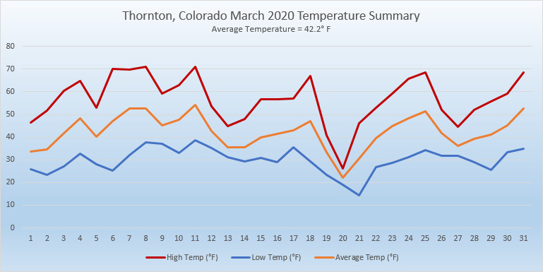
Thornton’s overall average temperature for the month came in at 42.2 degrees. This was a good bit above Denver’s March average of 40.4 degrees. Out at Denver International Airport where the Mile High City’s official records are kept, the reading nearly matched ours at 42.5 degrees.
Our warmest day on the 11th delivered a high of 71.1 degrees while our coldest, the 21st, saw a morning low of 14.2 degrees. Denver’s maximum reading of 68 degrees came on four different days. Their coldest of 11 degrees came on the 21st.
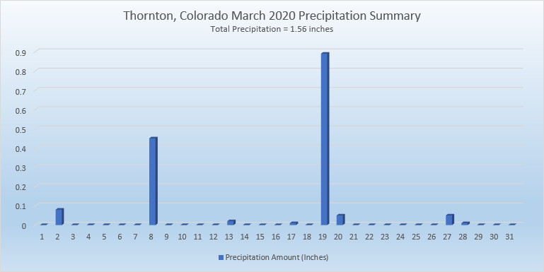
In terms of precipitation, Denver averages 0.92 inches in March. Thornton bested that easily with 1.56 inches and Denver did as well with 1.26 inches.
Both Thornton and Denver fell short of March’s average monthly snowfall of 10.7 inches. Thornton came closest with 9.3 inches while at the airport 7.5 inches was measured.
Click here to view Thornton’s March 2020 climate report.

The month of March is the start of meteorological spring and while conditions do begin warming, winter weather is certainly out of the question. From hot to cold, snow to rain, the conditions can be very conducive to great pictures as we see in our slideshow.
March in Denver typically means frequent and rapid weather changes. The days grow longer and we start enjoying more sunshine and sometimes summer-like weather. However, on occasion arctic air masses can still force their way south into Colorado dropping temperatures quickly and markedly.
With the active wildlife, increased outdoor activities by us humans, and of course the weather, March imagery contains a wide variety of subjects and extremes.
Showcasing images captured by ThorntonWeather.com readers as well as some of our own, our monthly slideshow covers the entire gamut of weather-related imagery.
Sunsets, sunrises, wildlife and of course every type of weather condition are vividly depicted in images captured from yours and our cameras.
| [flickr_set id=”72157713421651497″] |
What is missing in the slideshow above? Your photo!
Our monthly photo slideshow is going to feature images that we have taken but more importantly images that you have captured. The photos can be of anything even remotely weather-related.
Landscapes, current conditions, wildlife, pets, kids. Whimsical, newsy, artsy. Taken at the zoo, some other area attraction, a local park, a national park or your backyard. You name it, we want to see and share it!
Images can be taken in Thornton, Denver or anywhere across the extraordinary Centennial State. We’ll even take some from out of state if we can tie it to Colorado somehow.
We’ll keep the criteria very open to interpretation with just about any image eligible to be shown in our slideshows.
What do you win for having your image in our slideshow? We are just a ‘mom and pop’ outfit and make no money from our site so we really don’t have the means to provide prizes. However you will have our undying gratitude and the satisfaction that your images are shared on the most popular website in Thornton.
To share you images with us and get them included in the slideshow just email them to us or share them with ThorntonWeather.com on any of the various social media outlets. Links are provided below.
So come on, get those camera’s rolling!
This week in Denver weather history is notable for the variety of conditions that can be experienced this time of year. From hurricane force winds and heavy snow to more typical spring severe weather like tornadoes, all can be experienced this time of year.
From the National Weather Service:
27-29
In 1948…high winds raked Boulder. A wind gust to 75 mph was recorded at Valmont. Sustained winds in excess of 35 mph were estimated in Boulder. Minor damage was reported.
In 1961…heavy snowfall totaled 9.5 inches at Stapleton Airport over the 3 day period. Most of the snow…5.3 inches…fell on the 28th. Winds were generally light and gusted to only 22 mph from the north.
28-29
In 1891…rain changed to snow and totaled 9.7 inches in the city. Northeast winds were sustained to 12 mph with gusts to 28 mph on the 28th.
In 1910…a strong cold front brought much wind…rain…and and snow to the city. Rain on the 28th changed to snow early on the 29th. Snowfall totaled only 2.8 inches…but north winds were sustained to 50 mph on the 29th. Precipitation from the storm totaled 0.96 inch.
In 1994…moist upslope winds combined with an upper level system to dump 5 to 7 inches of snow along the eastern foothills and across metro Denver. Snowfall totaled 6.3 inches at Stapleton International Airport where northeast winds gusted to 39 mph. Thirteen inches of new snow were measured at the Eldora ski area west of Boulder.
28-30
In 1949…a major winter storm dumped 11.3 inches of snow over downtown Denver. Snowfall totaled 10.4 inches at Stapleton Airport. North to northeast winds were sustained to 17 mph.
In 1985…a slow moving snow storm moved across the state. Denver received only 4.0 inches of snowfall with amounts in the foothills totaling 1 to 2 feet. Still…this was enough snow in Denver to cause flight delays of up to 6 hours at Stapleton International Airport on the night of the 29th. East winds gusted to 28 mph on the 28th.
29
In 1887…west winds sustained to 44 mph warmed the temperature to a high of 62 degrees.
In 1921…post-frontal northeast winds were sustained to 46 mph with gusts to 52 mph.
In 1925…southeast winds were sustained to 46 mph with gusts to 48 mph. These were the strongest winds of the month that year. The winds warmed the temperature to a high of 72 degrees.
In 1934…a construction worker was killed by lightning as he walked with a shovel on his shoulder along Cherry Creek in the city. The thunderstorm produced light rain.
In 1967…a southwest wind gust to 52 mph was recorded at Stapleton International Airport. The warm Chinook winds warmed the temperature to 79 degrees equaling the record for the date.
In 1979…a tornado touched down 4 miles southwest of Parker… But caused no reported damage.
In 1998…four children attending a birthday party in Denver were injured when an apparent dry microburst produced a sudden strong wind gust which blew an inflatable playhouse they were occupying into a neighbor’s yard. The playhouse scraped the roof of the host’s two-story house…then landed in the adjoining yard. The children were treated for minor head injuries and cuts.
29-30
In 1938…overnight heavy snowfall was 6.3 inches over downtown Denver.
In 1982…strong winds buffeted metro Denver…breaking windows and damaging roofs. Wind gusts to 90 mph were recorded in Boulder and 51 mph at Stapleton Airport. The strong winds flattened a condominium under construction in Lakewood.
In 1991…1 to 6 inches of snow fell across metro Denver with the heaviest snow confined to the foothills. Six inches of snow was recorded at South Platte in the foothills southwest of Denver and 3 inches at Castle Rock. Snowfall totaled only 0.7 inch at Stapleton International Airport where northeast winds gusted to 33 mph on the 29th.
29-31
In 1970…snowfall totaled 6.0 inches at Stapleton International Airport. Heavy snow accumulation in Boulder on the 29th caused the collapse of a carport at an apartment building…damaging 11 automobiles. Northeast winds gusted to 24 mph at Stapleton International Airport.
30
In 1895…rain changed to sleet…then snow…and totaled 8.0 inches in downtown Denver. Strong post-frontal northeast winds were sustained to 48 mph with gusts to 61 mph. Temperatures hovered around 30 degrees all day.
In 1968…microburst winds associated with virga and brief light rain gusted to 46 mph at Stapleton International Airport.
In 1983…winds gusted to 82 mph at the National Center for Atmospheric Research in Boulder with peak gusts of 70 to 80 mph in the foothills. Minor damage occurred at a construction site and to some homes in Boulder. West winds gusted to 39 mph at Stapleton International Airport.
30-31
In 1896…heavy snowfall totaled 7.5 inches in downtown Denver. Northwest winds gusted to 26 mph.
In 1897…rain changed to snow during the early morning of the 30th and totaled 6.2 inches before ending during the late morning of the 31st. Northwest winds were sustained to 35 mph with gusts to 46 mph.
In 1929…heavy snowfall of 7.0 inches was recorded over downtown Denver. Northwest winds were sustained to 23 mph on the 30th.
In 1953…heavy snowfall totaled 8.6 inches at Stapleton Airport where northeast winds gusted to 23 mph.
In 1955…a vigorous cold front produced north winds at 40 mph with gusts as high as 54 mph at Stapleton Airport. Rain and snow showers and blowing dust accompanied the front. Snowfall totaled only 0.1 inch at Stapleton Airport on the 31st.
In 1988…snow began falling on the afternoon of the 30th and continued through the 31st…burying metro Denver. Twelve to 18 inches of snow fell in the foothills to the west of Denver and Boulder with 6 to 12 inches across the rest of metro Denver. The storm disrupted aircraft operations at Stapleton International Airport where snowfall totaled 7.1 inches and north winds gusting to 32 mph reduced the visibility to less than 1/4 mile at times…causing air traffic delays of 2 to 3 hours.
In 2000…heavy snow once again developed over the foothills and the higher terrain to the south of metro Denver. Snowfall totals from the storm included: 16 inches atop Squaw Mountain…15 inches near Rollinsville…13 inches near Evergreen…12 inches near Morrison…11 inches in Coal Creek Canyon…10 inches near Blackhawk and in Eldorado Springs…9 inches at Ken Caryl Ranch and larkspur… And 8 inches near Elizabeth. Snowfall totaled only 4.1 inches at the site of the former Stapleton International Airport. North winds gusted to 32 mph at Denver International Airport on the 30th.
In 2005…a strong spring storm intensified over the eastern plains of Colorado and produced near-blizzard conditions to the east and southeast of Denver overnight. North to northwest winds from 20 to 35 mph with gusts to 50 mph produced extensive blowing snow and caused near zero visibilities at times and snow drifts from 2 to 4 feet in depth. Snowfall amounts included: 12 inches near Bennett…8 inches around Castle Rock… 7 inches near Sedalia…and 6 inches near Parker. Only 0.3 inch of snow was reported at Denver Stapleton. At Denver International Airport…north winds gusted to 37 mph on the 30th and 36 mph on the 31st.
In 2014…on the evening of the 30th…high based showers and thunderstorms produced microburst winds over northern Jefferson…eastern Boulder and southwest weld counties. Peak wind reports included: 77 mph at white ranch open space; 72 mph…2 miles north of Longmont; 67 mph near Erie and firestone; 60 mph near mead and 59 mph…5 miles northwest of Henderson; with 53 mph at Denver International Airport. The wind downed power lines in Weld County which sparked a small fire. High winds then developed in the Front Range foothills and urban corridor through the morning of the 31st. Peak wind gusts included: 98 mph near gold hill; 77 mph near Eldorado Springs; 61 mph at Centennial Airport; 59 mph at Buckley Air Force Base; with 44 mph at Denver International Airport.
31
In 1873…high winds damaged buildings in the city. Northwest winds with sustained velocities to near 40 mph blew from 9:00 am until sunset.
In 1937…north to northeast winds sustained to 25 mph with gusts to 32 mph produced a light dust storm in the city during the afternoon.
In 1971…wind gusts to 92 mph were recorded in the south hills area of Boulder. At the National Bureau of Standards in Boulder sustained winds of 46 mph with gusts to 83 mph were measured. Damage was minor. Northwest winds gusted to 41 mph at Stapleton International Airport.
In 1983…high winds with gusts to 70 mph in Boulder caused minor damage.
31-1
In 1876…heavy snow began during the night and lasted all day on the 31st and through the morning of the 1st. The average depth of snow fall was 10 to 12 inches…but strong winds whipped the snow into drifts of 8 to 10 feet deep on the streets of the city. Precipitation from the storm was 1.03 inches on the 31st and 0.37 inch on the 1st.
In 1891…heavy moist snowfall totaled 18.0 inches in the city. Northeast winds were sustained to 20 mph with gusts to 24 mph on the 31st.
In 1936…northeast winds sustained to 21 mph produced a light dust storm in the city.
In 1975…a major storm dumped 9.3 inches of snowfall at Stapleton International Airport where northwest winds gusted to 41 mph. Rain changed to snow on the afternoon of the 31st…reducing the visibility to as low as 1/8 mile. Snow continued all day on the 1st and accumulated to a depth of 8 inches on the ground. The minimum temperature of 10 degrees on the 1st set a new record low for the date.
Continue reading March 29 to April 4: This week in Denver weather history
This week in Denver weather history are a number of interesting events. As March comes to a close we are not yet done with winter so snow is certainly still possible but we also start seeing more Spring-like weather. Reminders of this include the coldest temperature ever recorded in March – 11 degrees below zero 123 years ago. Conversely, 38 years ago the highest temperature ever recorded in March of 84 degrees was recorded.
From the National Weather Service:
20-22
In 1944…heavy snow fell over metro Denver for a total of 36 hours. The storm dumped 18.5 inches of snowfall over downtown Denver and 12.2 inches at Stapleton Airport. Fortunately…there were no strong winds with the storm. North winds to only 19 mph were recorded on the 21st.
21-22
In 1955…wind gusts to 98 mph were recorded at Rocky Flats south of Boulder. Some damage and a few minor injuries were reported in Boulder. Northwest winds were sustained to 28 mph with gusts to 39 mph at Stapleton Airport on the 22nd.
In 1966…a vigorous cold front produced only 1.7 inches of snowfall at Stapleton International Airport…but northeast winds gusted to 49 mph on the 21st. Temperatures cooled from a maximum of 66 degrees on the 21st to a minimum of 14 degrees on the 22nd. Strong winds occurred on both days.
In 1992…an arctic cold front produced upslope snow across metro Denver mainly west of I-25. Castle Rock reported 6 inches of snow with 3 inches at Evergreen. At Stapleton International Airport…only 1.5 inches of snowfall were measured and northeast winds gusted to 18 mph on the 21st.
22
In 1905…apparent post-frontal north winds were sustained to 49 mph.
In 1922…a vigorous cold front with north winds sustained to 41 mph brought only 0.6 inch of snowfall to the city. These were the highest winds of the month.
In 1966…high winds caused extensive blowing snow that impeded traffic and closed highways over a wide area of eastern Colorado. Wind damage was widespread…but minor. North wind gusts to 47 mph were recorded at Stapleton International Airport where visibility was reduced as low as 1/8 mile in blowing snow.
In 1975…a strong west wind gust to 51 mph was recorded at Stapleton International Airport…while east of Denver the strong winds caused minor property damage and considerable blowing dust which closed several roads.
In 1979…near-blizzard conditions paralyzed the northeastern quarter of the state. Strong winds and drifting snow closed many roads…including I-25 and I-70. Power outages darkened sections of metro Denver. Snow accumulations of 4 to 12 inches were measured over the plains with drifts several feet deep. Only 3.5 inches of snow were recorded at Stapleton International Airport where northeast winds gusted to 39 mph causing some blowing snow.
In 1995…strong winds associated with a fast moving pacific cold front moved from the mountains into metro Denver. Winds estimated at 60 to 75 mph picked up rocks and shattered the windows of a car in Louisville. The strong winds blew down and partially destroyed two houses under construction just north of Thornton. West winds gusted to 53 mph at Denver International Airport where the visibility was briefly reduced to 1/2 mile in blowing dust.
In 2016…two brief but powerful gustnadoes developed along a convergence line that formed in the suburbs just north and west of Denver. Three power poles were knocked down. In addition…a small storage shed was destroyed.
22-23
In 1936…heavy snowfall of 7.7 inches was measured in downtown Denver. The heavy wet snowfall formed a thick coating of snow on trees and shrubs…but caused little damage. North winds were sustained to 15 mph.
In 1984…around a half foot of new snow fell across metro Denver…causing flight delays at Stapleton International Airport where snowfall totaled 6.0 inches and north winds gusted to 31 mph. Up to a foot of snow fell in the foothills. Icy roads produced numerous traffic accidents.
In 2011…strong bora winds developed along the Front Range following the passage of a storm system. Peak wind gusts included: 87 mph at the National Wind Technology Center; 82 mph…6 miles northwest of Boulder; 72 mph at Front Range airport in Broomfield; 71 mph at Longmont; and 64 mph…4 miles west of Lakewood. At Denver International Airport…a peak wind gust of 48 mph from the west was observed on the 22nd.
In 2013…a wet early spring snowstorm brought heavy snow to parts of the Front Range foothills and urban corridor. The heaviest snowfall occurred near the Front Range foothills and palmer divide. Near blizzard conditions forced the closure of interstate 70 east of Denver. In the foothills… Storm totals included: 14.5 inches near Conifer; 14 inches just southwest of Eldorado Springs and Intercanyon; 13 inches near Indian Hills; 12.5 inches near Pinecliffe; 11.5 inches near Golden; 11 inches near Jamestown and Roxborough; 10.5 inches near Brookvale and 10 inches at Genesee. Across the urban corridor and Palmer Divide… Storm totals included: 12.5 inches…8 miles southeast of Watkins; 10.5 inches in Boulder…Centennial and Northglenn; 9.5 inches…just south of Aurora; 9 inches in Westminster; 8 inches at Lafayette; 7.5 inches near Morrison; 7 inches in Arvada…Bennett…Brighton; 6 inches in Highlands Ranch… Longmont…Louisville and Thornton. Officially…11.6 inches of snow fell at DIA from the evening of the 22nd to the afternoon of the 23rd…which set a new two-day snowfall record in Denver for the date. In addition…a peak wind gust to 33 mph was observed from the east on the 22nd with a gust to 30 mph from the north on the 23rd.
In 2016…a powerful blizzard developed across the Front Range of Colorado late on the 22nd and continued through much of the 23rd. The storm tracked east-southeast across Utah on the 22nd…and then into southeast Colorado by the morning of the 23rd. The storm rapidly intensified as it reached eastern Colorado…producing extremely heavy and intense snowfall with snowfall rates exceeding 3 inches per hour at times. In addition to heavy snow…strong winds gusting in excess of 50 mph east of I-25 produced widespread blizzard conditions and zero visibilities. The storm initially began with rain on the plains…but quickly changed over to snow during the early morning hours of the 23rd. Snowfall rates of 1 to 2 inches per hour were common…with several inches of snow already accumulating for the morning commute. Many roads became impassable due to the depth of fallen snow…drifting snow…and near zero visibilities during the day. During the peak of the storm… snowfall rates reached or exceeded 3 inches per hour. Widespread road closures occurred…including I-76 from northeast of Denver to the Nebraska state line…I-70 east of Denver to the Kansas state line…and much of I-25… from near Castle Rock to Colorado Springs. The Colorado Department of Transportation estimated over two thousand vehicles became trapped on I-25 near Monument Hill alone… with hundreds of stuck or abandoned cars elsewhere. Numerous power outages occurred as heavy wet snow accumulated on trees…despite the strong winds. At the peak…several hundred thousand residents along the Front Range were without power. Denver International Airport was closed for 7 hours during and just after the peak of the blizzard…with around 1300 cancelled flights. The power outages shut down the fuel farm pumps…the deicing facility…as well as train service to the concourses at the airport. Pea Boulevard…the main road to the airport…was impassable for much of the day. It was the first time since December 21…2006 that Denver International Airport had been shut down due to extreme winter weather conditions. One to 2 feet of snow fell across much of the Front Range Foothills and Urban Corridor. In the foothills of northern Jefferson County…31.5 inches of snowfall measured at Pinecliffe. Most of the snow fell within a 12-hr period from the early morning into the afternoon. A peak wind gust of 59 mph recorded at Denver International Airport. South of Denver…over the Palmer Ridge…12 to 18 inches of snow was reported…with 6 to 10 inches across the adjacent plains. The official snowfall measurement at Denver International Airport was 13.1 inches. In addition…the snow was very heavy and wet…with many areas receiving 1 to 2 inches precipitation. In the foothills…some locations received nearly 3 inches of water from this storm.
22-24
In 1965…a vigorous cold front swept across metro Denver late on the afternoon of the 22nd with east-northeast winds gusting to 38 mph causing some blowing dust. Snowfall from the storm totaled 4.4 inches at Stapleton International Airport. Temperatures on the 22nd dropped from a maximum of 63 degrees to 18 degrees in just 10 hours and dipped to 3 degrees below zero on the morning of the 24th. Maximum temperatures warmed to only 19 degrees on the 23rd and 18 degrees on the 24th.
23
In 1887…west winds sustained to 44 mph warmed the temperature to a high of 66 degrees.
In 1910…southwest winds were sustained to 40 mph. The Chinook winds warmed the temperature to a high of 73 degrees.
In 1913…west winds were sustained to 40 mph with a gust to 44 mph.
In 1951…a Chinook wind gust to 56 mph was recorded at Stapleton International Airport.
In 1957…strong north winds gusting to 62 mph reduced the visibility at times to 1 mile in blowing dust at Stapleton Airport as metro Denver dodged a major spring storm… Which produced heavy rain…snow…wind…and dust over eastern Colorado on the 22nd through the 25th. Snow drifted to 15-foot depths in some areas. All traffic was blocked…power lines were downed…and livestock and crop losses were high.
In 1994…strong winds raked the eastern foothills. While the highest winds occurred north of metro Denver…wind gusts to 74 mph were recorded atop Squaw Mountain near Idaho Springs and to 70 mph at Rocky Flats north of Golden. West wind gusts to 40 mph were recorded at Stapleton International Airport.
In 2005…lightning struck the roof of a home in paradise hills near Genesee. About 5 percent of the residence was damaged by the resulting fire.
Continue reading March 22 to March 28: This week in Denver weather history
The month of March in Denver is usually one that is welcomed heartily by residents. We begin to shake off the cold of winter with warmer temperatures and calmer conditions. That does not mean we are done with snow and cold by any means.
March usually offers healthy snowfall giving us an opportunity to add to our seasonal totals. While there is good snow potential in March, the month also typically brings much warmer temperatures.
March is historically Denver’s snowiest month and brings about 20% of our annual snowfall. Heavy, wet spring snow storms can oftentimes bring the entire month’s snowfall total in one monstrous snow.
We also start the transition to spring and severe weather season and the month typically brings our first thunderstorms of the year. Temperatures climb throughout the month and by the end our average daytime highs are near 60 degrees.
For a complete look at what lies ahead in March 2020, click here.
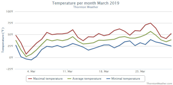
The unstable, cold and wet weather that marked February continued right on into March. Once again, we saw temperatures well below normal and a good bit more than average precipitation.
While the first day of the month started things off relatively nicely, the second brought the first bout of cold. Temperatures plummeted with highs on the third only in the single digits and nighttime low temperatures below zero on the 3rd and 4th. This was coupled with a nice shot of 3.4 inches of snow on the 3rd.
We then slowly warmed up and enjoyed near normal temperatures for a brief period of time. This changed quickly and significantly with the arrival of a blizzard on the 13th. Powerful winds coupled with snow shut down schools, businesses, highways and Denver International Airport.
Calmer, drier weather then took hold for much of the rest of the month although most days continued to see temperatures below normal. The 26th and 27th did offer up our first days of 70 degree or warmer temperatures.
The month closed out with another shot of cold on the 29th and 30th and a light bit of snow.
Thornton’s overall average temperature for the month of March was 35.1 degrees. Out at Denver International Airport here the Mile High City’s official measurements are taken, they matched our temperature with an average of 35.1 degrees as well. Both were well below the historical average March temperature for Denver of 40.4 degrees.
Temperatures in Thornton ranged from a maximum reading of 74.9 degrees on the 27th down to a low of -5.0 degrees on the morning of the 4th. Denver saw its maximum of 73 degrees on the 27th and its minimum of -6 degrees on the 3rd.
Denver set a record low maximum for March 3rd when the temperature only reached a high of 6 degrees. The old record was 14 degrees set in 1978. Additionally, a low temperature reading of -3 degrees on the 4th tied the record low for the date also set in 1960 and 1978.
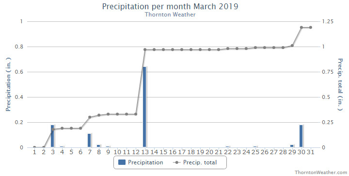
In terms of precipitation, Thornton recorded 1.19 inches in our bucket while Denver bested us with 1.39 inches. Both were above the long term Denver average for the month of March of 0.92 inches.
Denver’s 0.64 inches of liquid precipitation on the 13th set a daily record, easily besting the old record of 0.43 inches (1926) for the date.
Denver averages 10.7 inches of snow during the month of March. Thornton and Denver beat the average with measurements of 12.2 inches and 12.9 inches respectively.
Click here to view Thornton’s March 2019 climate report.
CLIMATE REPORT
NATIONAL WEATHER SERVICE DENVER/BOULDER CO
938 AM MDT MON APR 1 2019

...................................

...THE DENVER CO CLIMATE SUMMARY FOR THE MONTH OF MARCH 2019...

CLIMATE NORMAL PERIOD 1981 TO 2010
CLIMATE RECORD PERIOD 1872 TO 2019

WEATHER         OBSERVED          NORMAL  DEPART  LAST YEAR`S
                 VALUE   DATE(S)  VALUE   FROM    VALUE  DATE(S)
                                          NORMAL
................................................................
TEMPERATURE (F)
RECORD
 HIGH              84   03/26/1971
 LOW              -11   03/28/1886
HIGHEST            73   03/27                         73  03/22
LOWEST             -6   03/03                         13  03/07
AVG. MAXIMUM     46.7              54.4    -7.7     58.5
AVG. MINIMUM     23.5              26.4    -2.9     26.8
MEAN             35.1              40.4    -5.3     42.7
DAYS MAX >= 90      0               0.0     0.0        0
DAYS MAX <= 32      3               1.9     1.1        0
DAYS MIN <= 32     28              23.6     4.4       27
DAYS MIN <= 0       3               0.1     2.9        0

PRECIPITATION (INCHES)
RECORD
 MAXIMUM         4.56   1983
 MINIMUM         0.03   2012
TOTALS           1.39              0.92    0.47     1.02
DAILY AVG.       0.04              0.03    0.01     0.03
DAYS >= .01         9               5.9     3.1        6
DAYS >= .10         6               2.4     3.6        3
DAYS >= .50         1               0.3     0.7        0
DAYS >= 1.00        0               0.1    -0.1        0
GREATEST
 24 HR. TOTAL    0.64   03/13 TO 03/13           03/18 TO 03/18

SNOWFALL (INCHES)
RECORDS
 TOTAL           12.9              10.7
RECORD MARCH     35.2    2003

DEGREE_DAYS
HEATING TOTAL     919               763     156      684
 SINCE 7/1       5336              5202     134     4741
COOLING TOTAL       0                 0       0        0
 SINCE 1/1          0                 0       0        0

FREEZE DATES
RECORD
 EARLIEST     09/08/1962
 LATEST       06/08/2007
EARLIEST                        10/07
LATEST                          05/05
.................................................................

WIND (MPH)
AVERAGE WIND SPEED              10.2
RESULTANT WIND SPEED/DIRECTION   1/060
HIGHEST WIND SPEED/DIRECTION    60/340    DATE  03/13
HIGHEST GUST SPEED/DIRECTION    80/340    DATE  03/13

SKY COVER
POSSIBLE SUNSHINE (PERCENT)   MM
AVERAGE SKY COVER           0.60
NUMBER OF DAYS FAIR            4
NUMBER OF DAYS PC             16
NUMBER OF DAYS CLOUDY         11

AVERAGE RH (PERCENT)     67

-  INDICATES NEGATIVE NUMBERS.
R  INDICATES RECORD WAS SET OR TIED.
MM INDICATES DATA IS MISSING.
T  INDICATES TRACE AMOUNT.