|
Tag Archives: Floods
North Korea Floods Kill 133, Displace 107,000: U.N.
|
Adoring press detail Obama’s golf, vacation while Louisiana is underwater
|
Three days of heavy downpours have brought historic flooding to Louisiana, where 30 parishes have declared to be a disaster, and the death toll has climbed to 13. The U.S. Coast Guard and other first responders rescued more than 20,000 people over the weekend, as the massive flooding inundated areas in and around Baton Rouge. More… Continue reading Adoring press detail Obama’s golf, vacation while Louisiana is underwater |
Obama: Mississippi Flooding an Official Disaster
|
President Barack Obama declared on Monday afternoon that the flooding and tornadoes that hit Mississippi in late December constitute an official major disaster. The declaration frees up federal dollars to go toward aiding five particularly storm-struck areas in the state: Benton, Coahoma, Marshall, Quitman and Tippah counties. Mississippi Governor Phil Bryant expressed gratitude to Obama and… Continue reading Obama: Mississippi Flooding an Official Disaster |
Worst floods for 70 years swamp northern England
|
Parts of northern England are suffering their worst floods in more than 70 years with weeks of heavy rain leaving vast areas under water on both sides of the Pennines mountains. British Prime Minister David Cameron has sent in 500 soldiers to help the exhausted residents and emergency workers. A further 1,000 troops remain on standby.… Continue reading Worst floods for 70 years swamp northern England |
At Least 6 Dead In Southern Utah Flash Flood
|
At least six people were dead and several others were missing after heavy rains in southern Utah triggered flash flooding, authorities said Monday night. Those missing are reportedly from Colorado City and Hildale area, near the Utah-Arizona border. Hildale officials reportedly said that a flash flood washed two vehicles off the road at Canyon Street and… Continue reading At Least 6 Dead In Southern Utah Flash Flood |
Drive into the mountains brings stark reminders of Colorado’s September 2013 floods
We went for a drive through Estes Park and into Rocky Mountain National Park yesterday. Always beautiful but now, a bit more dramatic for other reasons.
The devastation from last year’s floods are still very visible and while much has done rebuilding, much more needs to be done. Here you can see what is left of a car after being caught in the flood on Highway 34. In the background, the collapsed hillside is seen and two construction vehicles work to rebuild the riverbank.
Piles of debris and rubble as still visible as you climb up the canyon. While some houses have been rebuilt, others remain in pieces.

Video: NASA showcases weather and climate events of 2013 as seen from space
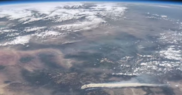
A stunning video released by NASA this week provides a bird’s eye view of some of the Earth’s most significant weather and climate events of last year.
Using images and movies from satellites and the International Space Station, scenes from across the globe are shown in the video titled “Earth from Orbit 2013.”
Colorado and surrounding states however will draw the most attention from many locally.
From their perch high above, imagery of Colorado’s West Fork Fire in June 2013 is seen as well as the effects of the September floods.
To our south, the drought in New Mexico is seen having taken its toll on Elephant Butte Reservoir in New Mexico. The veritable explosion of storm cells that lea to devastation in Oklahoma during a May tornado outbreak are also shown.
Below the video you will find a description of each scene and links to more imagery.
From NASA – Published on Apr 21, 2014:
A fleet of orbiting satellites monitors Earth constantly. The satellites from NASA and other space agencies give us a fresh, wide perspective on things that we can see from the ground — and things that we can’t.
A look back at Earth in 2013 from the viewpoint of orbit reveals the kind of data gathering and technical achievement that are the reason NASA puts Earth-observing satellites in space. A visualization of satellite and computer model data shows how a cloud of dust from the Chelyabinsk meteor moved around the world. NASA satellites measured the intensity of wildfires, the salinity of the oceans and rainfall around the globe — whether it was too little or too much.
To learn more about NASA’s Earth science in 2014, please visit: www.nasa.gov/earthrightnow
Imagery used in this video, in order:
Views of a Distant Earth
http://earthobservatory.nasa.gov/IOTD…
Earth and Moon
http://svs.gsfc.nasa.gov/vis/a000000/…
Current Earth Observing Fleet
http://svs.gsfc.nasa.gov/vis/a030000/…
Term3_ISS From Night to Day to Night Again
http://eol.jsc.nasa.gov/Videos/CrewEa…
Astronaut View of Fires in Colorado
http://earthobservatory.nasa.gov/Natu…
Extensive Ice Fractures in the Beaufort Sea
http://earthobservatory.nasa.gov/IOTD…
Dune Movement Around Aorounga
http://earthobservatory.nasa.gov/IOTD…
San Francisco Region at Night
http://earthobservatory.nasa.gov/IOTD…
Whiting Event, Lake Ontario
http://earth.jsc.nasa.gov/debrief/ISS…
Dust Plumes over the Mediterranean
http://earthobservatory.nasa.gov/Natu…
Mt. St. Helens
http://earthobservatory.nasa.gov/IOTD…
El Paso
http://earthobservatory.nasa.gov/IOTD…
Close-Up of Flooding in Mozambique
http://earthobservatory.nasa.gov/IOTD…
Drought Dries Elephant Butte Reservoir
http://earthobservatory.nasa.gov/IOTD…
Oklahoma Tornadoes
http://earthobservatory.nasa.gov/Natu…
Floods in Colorado
http://earthobservatory.nasa.gov/Natu…
Pavlof Volcano
http://earthobservatory.nasa.gov/Natu…
Swirling Sediment Reveals Erosive Power of New England Storm
http://earthobservatory.nasa.gov/IOTD…
Never at Rest: The Air over Los Angeles
http://svs.gsfc.nasa.gov/vis/a000000/…
Measuring Soil Moisture from Space
http://svs.gsfc.nasa.gov/vis/a030000/…
Antarctic Bedrock
http://svs.gsfc.nasa.gov/vis/a000000/…
Seeing Photosynthesis from Space
http://svs.gsfc.nasa.gov/vis/a010000/…
Greenland’s Mega Canyon
http://svs.gsfc.nasa.gov/vis/a000000/…
Chelyabinsk Bolide Plume as seen by NPP and NASA Models
http://svs.gsfc.nasa.gov/vis/a000000/…
Narrated Distributed Water Balance of the Nile Basin
http://svs.gsfc.nasa.gov/vis/a010000/…
NEO Observations (various)
http://svs.gsfc.nasa.gov/cgi-bin/advs…
Video captures virtually impassable US 34 near Drake following flooding
[pe2-image src=”http://lh4.ggpht.com/-ay57f6lobfs/Uki4iBmH3II/AAAAAAAAAv0/-rN3zB9mnJw/s144-c-o/co-drake.jpg” href=”https://picasaweb.google.com/108306177534978229224/September2013ColoradoSFloods?authkey=Gv1sRgCOa7nK-5oPKyvQE#5929191804116655234″ caption=”US.34 near Drake is siimply no longer in existence in the wake of the flooding. Image taken September 28, 2013. (Loveland Fire Rescue Authority)” type=”image” alt=”co-drake.jpg” pe2_single_image_size=”w300″ ]
Recovery following Colorado’s devastating floods will be a painstaking process that takes months and years. New video showcases one, small part of the destruction but serves as a reminder as to just how extensive the damage is.
US Highway 34 between Loveland and Estes Park is no stranger to flood damage. Once again, the canyon areas were among the hardest hit in the state and the highway was entirely destroyed in many locations.
Personnel with the Loveland Fire Rescue Authority rode an ATV up the canyon to near Drake this past Saturday, September 28, 2013, and recorded it on video using a helmet mounted camera. The highway is impassable by car and one of the areas that required extensive aerial rescues to help residents stranded by the flood waters.
Entire sections of the road are destroyed as the rider is forced to evade downed power lines and scattered debris. At one point, he appears to be riding in the river but instead is riding where there used to be a highway.
The three-minute video is well worth watching.
Before and after: NASA satellite imagery reveals flood damage in Colorado
Colorado’s September 2013 floods have been absolutely devastating with over 1,500 homes destroyed and a death toll yet to be finalized. NASA satellites flew over the area near Greeley in recent days and the before and after pictures provide a stunning view from above of the devastation.
Using the ‘sliders’ on the two image sets below you can compare how the area looks normally versus how it looked in the days immediately after the flooding.
[wpw_ba_viewer width=”600″ height=”auto” anim_speed=”600″ start_percent=”0.5″ disable_intro=”false”]
[wpw_ba_img src=”http://lh6.googleusercontent.com/-EHZnr2QxwDo/UjxBTiFTICI/AAAAAAAAArY/lN8SZl9OGLs/s600/greeley-before.jpg” data_second=”http://lh3.googleusercontent.com/-Afkp7QnthD8/UjxBTnDEMrI/AAAAAAAAArU/QsAh-2SWRkw/s600/greeley-after.jpg” title=”Satellite imagery comparison of the area near Greeley, Colorado before and after the September 2013 flooding. (NASA EO)” data_info=”Satellite imagery comparison of the area near Greeley, Colorado before and after the September 2013 flooding. (NASA EO)”]
[/wpw_ba_viewer]Satellite Imagery of Flooding Near Greeley, Colorado – “Though water levels on the South Platte River were receding, muddy brown waters were still out of the river’s banks near Greeley, Colorado, on September 17, 2013, when the Operational Land Imager (OLI) on the Landsat 8 satellite acquired this image. At the time, the river was more than six feet above flood stage, down from more than eight feet above flood stage.” The before image was acquired on June 29, 2013 and shows the area as it normally appears. (NASA EO)
[wpw_ba_viewer width=”600″ height=”auto” anim_speed=”600″ start_percent=”0.5″ disable_intro=”false”]
[wpw_ba_img src=”http://lh4.googleusercontent.com/-4P17RwE0yJ4/UjxBUXq6AEI/AAAAAAAAArc/jf6eRTTMaeQ/s600/platte-before.jpg” data_second=”http://lh6.googleusercontent.com/-oFx1h0x653Y/UjxBTgBj2KI/AAAAAAAAArM/-rgcmbR2otk/s600/platte-after.jpg” title=”Satellite imagery comparison of the area near Greeley, Colorado before and after the September 2013 flooding. (NASA EO)” data_info=”Satellite imagery comparison of the area near Greeley, Colorado before and after the September 2013 flooding. (NASA EO)”]
[/wpw_ba_viewer]Infrared Satellite Imagery of Flooded South Platte River – “Intense rainfall in northern and eastern Colorado brought widespread, destructive flooding in mid-September 2013. Local citizens reported as much as 18 inches (46 centimeters) of rain from September 9 to 15, with some of the heaviest accumulation along the Front Range of the Rocky Mountains. A break in the precipitation allowed the Moderate Resolution Imaging Spectroradiometer (MODIS) on NASA’s Aqua satellite to acquire the top image of the floods on September 14. The second image, taken by Terra MODIS on September 7, 2013, shows the region before the rains began. The images were made from infrared light to increase the contrast between water and land.” (NASA EO)