Many notable weather events have occurred in Denver this week in the past, some recently. It was just last year that a windstorm knocked down trees and powerlines in Boulder. Nine years ago, we saw an end to 61 days straight with snow cover – the second longest streak in Denver history.
From the National Weather Service:
13-14
In 1895…a cold air mass settled over the city. High temperatures of only 4 degrees on the 13th and 8 degrees on the 14th were record low maximum temperatures for each day. Low temperatures were 6 degrees below zero on the 13th and 5 degrees below zero on the 14th…but were not records. Light snow totaled only 0.4 inch. Winds were light.
In 1960…snowfall totaled 6.1 inches and north-northwest winds gusted to 39 mph at Stapleton Airport.
In 1967…high winds were widespread along the foothills where wind gusts of 60 to 90 mph were common. A wind gust to 108 mph was measured at the National Center for Atmospheric Research in Boulder. Sustained winds of 50 to 55 mph with gusts as high as 70 mph were recorded in downtown Boulder. An estimated 3 thousand dollars in damage occurred to mobile homes in Boulder. Power lines were downed over a wide area. At Stapleton International Airport…west winds gusted to 32 mph on the 13th and southwest winds gusted to 48 mph on the 14th.
In 1972…winds gusted to 67 mph at the National Bureau of Standards in Boulder. Wind gusts to 49 mph were measured in downtown Boulder. West winds gusted to 26 mph at Stapleton International Airport.
In 2001…heavy snow fell across metro Denver and in the foothills. Snowfall totals included: 8 inches at Evergreen; 7 inches atop Crow Hill and in Lakewood; 6 inches in Denver…Doubleheader…Eldorado Springs… Morrison…and Pine Junction. Snowfall totaled 4.8 inches at the site of the former Stapleton International Airport. Northeast winds gusted to 33 mph at Denver International Airport on the 13th.
14
In 1918…southwest winds were sustained to 41 mph with a measured extreme velocity to 46 mph.
In 1987…metro Denver received only 3 to 4 inches of snow… But the foothills west of Boulder received up to 11 inches of snow. Snowfall totaled 4.2 inches at Stapleton International Airport where north winds gusted to 31 mph.
In 1988…winds gusted to 81 mph at Echo Lake.
In 2002…high winds developed in the Front Range foothills during the early morning hours. Winds gusted to 84 mph… 11 miles north of central city. West winds gusted to 43 mph at Denver International Airport.
14-15 in 1960…heavy snowfall totaled 6.1 inches at Stapleton Airport.
In 1965…5.4 inches of snow fell at Stapleton International Airport behind a cold front. North-northeast winds gusted to 32 mph. Winds were strong and gusty all day and caused considerable blowing snow…contributing to hazardous driving conditions mainly to the east of Denver.
In 1984…a snow and wind storm howled across eastern Colorado closing I-70 east of Denver. This was the second blizzard in less than 4 days. Only 0.5 inch of new snow fell at Stapleton International Airport…but north winds gusted to 51 mph.
15
In 1881…the temperature plunged to a low of 20 degrees below zero in the city. In outer areas of the city…the temperature dipped to 26.5 degrees below zero.
In 1910…west winds were sustained to 42 mph.
In 1986…high winds battered the Front Range foothills. A wind gust to 95 mph was recorded in Boulder…but winds of 60 to 80 mph were common in and near the foothills. In Aurora…an automobile dealership lost a large plate glass window. Southwest wind gusts to 44 mph were recorded at Stapleton International Airport. The strong winds warmed temperatures. A record maximum temperature of 66 degrees and a record high minimum temperature of 37 degrees were recorded at Stapleton International Airport.
In 1988…winds to 75 mph were clocked in Boulder…while a west wind gust to only 41 mph was recorded at Stapleton International Airport.
In 1997…winds gusted to 75 mph at Golden Gate Canyon during the early morning hours. West winds gusted to 31 mph at Denver International Airport.
In 2000…high winds spread from the foothills onto the plains. While the strongest winds were north and northeast of metro Denver…west winds gusted to 58 mph in Thornton and to 54 mph at Denver International Airport.
In 2005…light precipitation of only 0.02 inch at Denver International Airport was the only measurable precipitation of the month. This ranked the month as the 2nd driest February of record.
15-16
In 1889…heavy snowfall totaled 6.7 inches in downtown Denver. Most of the snow…5.5 inches…fell on the 15th when northeast winds were sustained to 18 mph.
In 1921…strong Bora winds cooled maximum temperatures from the 60’s on the previous 3 days to 54 degrees on the 15th and to 43 degrees on the 16th. West winds were sustained to 39 mph with gusts to 54 mph on the 15th and to 46 mph with gusts to 56 mph on the 16th.
In 1953…strong…cold northwest winds were widespread from the foothills across the plains. Near gale force winds were observed in Boulder. A wind gust to 54 mph was recorded at Stapleton Airport where blowing dust briefly reduced the visibility to 1 1/2 miles. Damage was minor.
In 1993…an arctic cold front pushed south over the eastern Colorado plains with upslope snow developing behind the front. Snowfall amounts of 3 to 6 inches were common over metro Denver. At Stapleton International Airport…snowfall totaled 4.5 inches and north winds gusted to 25 mph. Temperatures hovered only in the single digits for most of the day. The storm produced up to a foot of snow over southeast Colorado.
In 2005…light snowfall of 0.5 inch at Denver Stapleton was the only measurable snowfall of the month…which ranked the month the 2nd least snowiest February of record.
In 2006…overnight snowfall in the mountains and eastern foothills contained a lot of red dust and dirt apparently from Arizona. Strong southwest winds with gusts to 100 mph in the San Juan Mountains on the 15th created widespread blowing dust. This red dust became entrained in snowfall across the area. The reddish colored snow was reported in Ward…Nederland…Blackhawk…and Boulder. The storm produced only 0.9 inch of snowfall in the Stapleton area of Denver with 4 to 5 inches measured in the foothills.
15-17
In 1938…a cold air mass brought a light snowfall of 6.2 inches over 3 days to downtown Denver where northeast winds were sustained to 18 mph on the 15th.
16
In 1879…a sudden burst of 3 inches of snow in less than 90 minutes stopped the street cars in downtown Denver during the late afternoon. Melted snow resulted in 0.16 inch of precipitation. Small soft hail also fell when the snow began. A gentleman caught on the prairie between Denver and Morrison described the event as the most severe storm of the winter while it lasted.
In 1885…a windstorm caused severe damage in the city. The strong winds blew all afternoon and most of the evening. West winds were sustained to 62 mph. The strong winds blew down signs and broke windows. Buggies and vehicles of all kinds were blown over. Smokestacks and chimneys were toppled. Roofs were blown off. The Denver and Rio Grande Railroad car shop was partially unroofed and had a wall blown down. Three railroad cars were blown off the track. Many fences were damaged.
In 1897…west winds were sustained to 46 mph with gusts to 56 mph.
In 1912…northwest winds were sustained to 44 mph with a measured extreme velocity to 45 mph.
In 1921…west winds were sustained to 46 mph.
In 1972…wind gusts to 58 mph were recorded at the National Bureau of Standards in Boulder. In downtown Boulder…a wind gust to 51 mph was measured. Northwest winds gusted to 41 mph at Stapleton International Airport.
In 1988…snowfall totaled 3 to 6 inches across metro Denver… But 9 inches were measured in both Wheat Ridge and Evergreen. At Stapleton International Airport…3.4 inches of snow fell and northeast winds gusted to 26 mph. The strong winds blew a scaffold against a hotel in downtown Denver…breaking three windows.
In 1995…high winds occurred in the foothills behind a departing winter storm. A wind gust to 91 mph was recorded at Rollinsville with a gust to 82 mph atop Squaw Mountain west of Denver. West winds gusted to only 20 mph at Stapleton International Airport.
In 2014…a peak wind gust to 59 mph…from the west… Was recorded at Denver International Airport.
Continue reading February 14 to February 20: This week in Denver weather history
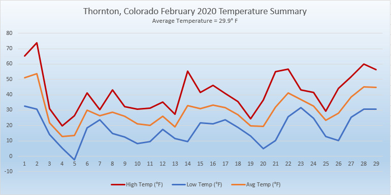
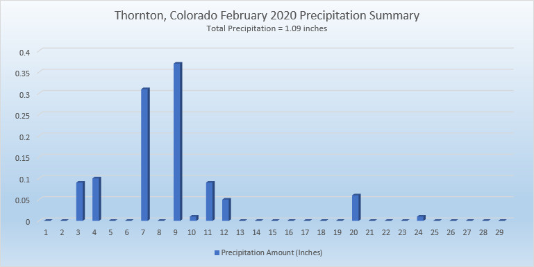
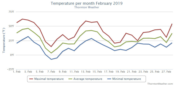
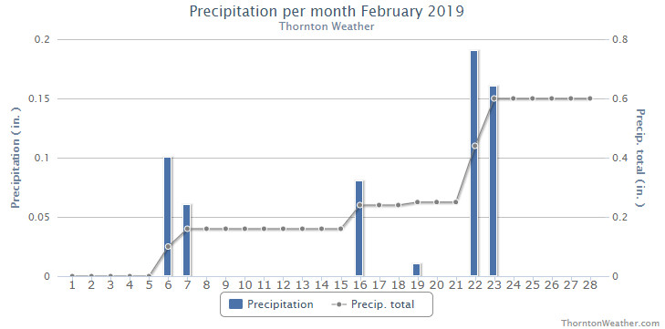
 February in Colorado typically brings to an end an extended period when average temperatures are at their lowest. Winter begins to loosen its grip and temperatures get warmer but precipitation is not a particularly common event during the month.