|
Irma’s deadly passage batters Caribbean
|
A Look At Voyager’s 40 Year Journey
|
Irma is now the strongest Atlantic Ocean hurricane ever
|
Al Gore Outsold On Kindle By An E-Book Debunking ‘An Inconvenient Sequel’
|
Caribbean girds for Hurricane Irma threat
|
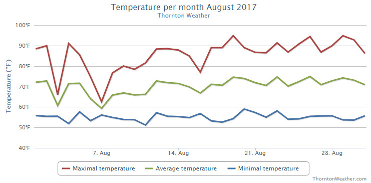
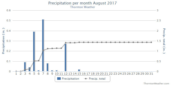
August 2017 weather recap: Cooler than normal with near average precipitation
The last full summer month of the year has come to a close in a rather un-dramatic fashion. Thornton saw a largely pleasant month with temperatures a good bit cooler than we usually expect to see. Precipitation was right near normal however, all of it fell during the first half of the month.
High pressure ruled for the first two days of the month but then the ridge broke down bringing about cooler temperatures on the 3rd of the month. The cool down didn’t last long and while the heat returned for a couple of days, we did finally receive some moisture on the 4th and 5th.
Cooler than normal temperatures returned on the 6th and lasted through the next 10 days. The first half of the month also saw 10 days with measurable precipitation, our only precipitation for the month as the last half of the month saw none at all.
Dry and warm conditions were the rule of thumb for the last two weeks of the month. Both Thornton and Denver saw six of the last nine days of the month bring high temperatures at or above 90 degrees.
Our average temperature for the month came in at 68.9 degrees. This was a good bit below the long term Denver average for August of 72.5 degrees. Out at DIA where the Mile High City’s official measurements are taken, the month was warmer than us but still cooler than normal with an average of 71.5 degrees.
Temperatures in Thornton ranged from a high mark reading of 94.9 degrees on the 29th of the month down to a low of 51.2 degrees on the 11th. Denver saw a maximum reading of 95 degrees on the 19th of the month and a low of 51 degrees on the 4th.
In terms of precipitation, Denver averages 1.69 inches of precipitation during August. Thornton wasn’t too far short of that with 1.43 inches. However, all of that came during the first 15 days of the month. After that, we saw nothing. Denver best us, and the average, with 1.86 inches in their rain bucket.
Click here to view Thornton’s August 2017 climate report.
CLIMATE REPORT
NATIONAL WEATHER SERVICE DENVER/BOULDER CO
639 PM MDT FRI SEP 1 2017

...................................

...THE DENVER CO CLIMATE SUMMARY FOR THE MONTH OF AUGUST 2017...

CLIMATE NORMAL PERIOD 1981 TO 2010
CLIMATE RECORD PERIOD 1872 TO 2017

WEATHER         OBSERVED          NORMAL  DEPART  LAST YEAR`S
                 VALUE   DATE(S)  VALUE   FROM    VALUE  DATE(S)
                                          NORMAL
................................................................
TEMPERATURE (F)
RECORD
 HIGH             105   08/08/1878
 LOW               40   08/26/1910
                        08/25/1910
                        08/24/1910
HIGHEST            95   08/19        96      -1       97  08/09
LOWEST             51   08/04        50       1       47  08/25
                                                          08/20
AVG. MAXIMUM     85.7              87.2    -1.5     86.3
AVG. MINIMUM     57.3              57.9    -0.6     56.2
MEAN             71.5              72.5    -1.0     71.2
DAYS MAX >= 90     10              11.5    -1.5       15
DAYS MAX <= 32      0               0.0     0.0        0
DAYS MIN <= 32      0               0.0     0.0        0
DAYS MIN <= 0       0               0.0     0.0        0

PRECIPITATION (INCHES)
RECORD
 MAXIMUM         5.85   1979
 MINIMUM         0.02   1924
TOTALS           1.86              1.69    0.17     0.22
DAILY AVG.       0.06              0.05    0.01     0.01
DAYS >= .01         6               8.6    -2.6        4
DAYS >= .10         4               4.3    -0.3        1
DAYS >= .50         2               1.2     0.8        0
DAYS >= 1.00        0               0.3    -0.3        0
GREATEST
 24 HR. TOTAL    0.90   08/07 TO 08/07           08/24 TO 08/24

SNOWFALL (INCHES)
RECORDS TOTAL     0.0
TOTALS            0.0 2017          0.0


DEGREE_DAYS
HEATING TOTAL       8                10      -2       15
 SINCE 7/1          8                16      -8       15
COOLING TOTAL     216               244     -28      218
 SINCE 1/1        749               688      61      762

FREEZE DATES
RECORD
 EARLIEST     09/08/1962
 LATEST       06/08/2007
EARLIEST                        10/07
LATEST                          05/05
.........................................................

WIND (MPH)
AVERAGE WIND SPEED              9.2
RESULTANT WIND SPEED/DIRECTION   2/189
HIGHEST WIND SPEED/DIRECTION    49/320    DATE  08/04
HIGHEST GUST SPEED/DIRECTION    62/320    DATE  08/04

SKY COVER
POSSIBLE SUNSHINE (PERCENT)   MM
AVERAGE SKY COVER           0.50
NUMBER OF DAYS FAIR            7
NUMBER OF DAYS PC             21
NUMBER OF DAYS CLOUDY          3

AVERAGE RH (PERCENT)     50

WEATHER CONDITIONS. NUMBER OF DAYS WITH
THUNDERSTORM             13     MIXED PRECIP               0
HEAVY RAIN                3     RAIN                       4
LIGHT RAIN               12     FREEZING RAIN              0
LT FREEZING RAIN          0     HAIL                       0
HEAVY SNOW                0     SNOW                       0
LIGHT SNOW                0     SLEET                      0
FOG                      10     FOG W/VIS <= 1/4 MILE      2
HAZE                      2

-  INDICATES NEGATIVE NUMBERS.
R  INDICATES RECORD WAS SET OR TIED.
MM INDICATES DATA IS MISSING.
T  INDICATES TRACE AMOUNT.
September 3 to September 9: This week in Denver weather history

The first full week of September sees us start one of the most pleasant times of year in Denver. While less common this time year, severe weather can and does occur. Our look back at this week in Denver weather history includes hail, damaging wind and even smoke from wildfires hundreds of miles away.
From the National Weather Service
1-5
In 1995…record breaking heat occurred on the first 5 days of the month when the temperature climbed into the 90’s on each day. Record high temperatures of 97 degrees on both the 1st and 4th equaled the all-time record maximum for the month. High temperature of 95 degrees on the 3rd was a record for the date. High temperatures of 94 degrees on both the 2nd and the 5th were not records. The low temperature of 64 degrees on the 4th equaled the record high minimum for the date.
1-7
In 1978…the temperature reached 90 degrees or more on seven consecutive days with the highest temperature…94 degrees… Recorded on both the 4th and 6th.
2-3
In 1892…there was a trace of rainfall each day. This… Together with a trace of rain on both the 7th and 8th…was the only rainfall of the month…making the month the driest on record. The monthly record was equaled in 1944.
3
In 1901…a thunderstorm produced rain…hail of unknown size… And south winds sustained to 40 mph with gusts to 43 mph.
In 1961…Labor Day snow storm is the earliest date of the first snow…trace and measurable…of the season. The heavy wet snow broke many limbs from trees that were still in full foliage. The storm produced 4.2 inches of snowfall at Stapleton Airport with nearly a foot of snow in western suburbs and in the foothills. Minimum temperature of 33 degrees was a record for the date and the coldest ever recorded so early in the season.
In 1999…severe thunderstorms dumped large hail across metro Denver. Hail as large as 1 inch in diameter was measured near Cherry Creek in Aurora and near Bennett. Hail to 3/4 inch in diameter fell in the city of Denver.
In 2002…a thunderstorm produced a wind gust to 51 mph at Denver International Airport.
In 2003…very heavy thunderstorm rain washed out parts of the Virginia Canyon Road above Idaho Springs. Up to 4 feet of mud reportedly washed down the road during the storm. Several vehicles were trapped on the road.
In Idaho Springs…several streets…including the main street… Were also buried in mud and gravel. Some buildings in town experienced minor flooding…including the basement of the town library and the police station.
3-6
In 1909…rainfall for the 4 days accumulated to 3.97 inches in Boulder…while in Denver rainfall totaled 2.45 inches on the 4th…5th…and 6th.
4
In 1909…apparent post-frontal heavy rainfall totaled 1.94 inches in downtown Denver. North winds were sustained to 19 mph.
In 1944…a trace of rain fell. This together with a trace of rain on the 9th…10th…and 30th was the only precipitation for the month. The total of a trace of precipitation for the month equaled the driest September on record first set in 1892.
In 1960…the highest recorded temperature in September…97 degrees…occurred. The same temperature also occurred on September 5…1899…September 1…1995…and September 4… 1995.
In 1989…a strong thunderstorm wind gust flipped a plane taxiing on a private runway in Adams County east of Denver. Two people were slightly injured and the plane was heavily damaged.
In 1992…strong winds developed across metro Denver behind a pacific cold front. Sustained winds above 40 mph with gusts as high as 60 mph were recorded mainly in and near the foothills. Pre-frontal south winds gusted to 37 mph at Stapleton International Airport.
In 1995…two people were injured when lightning struck their home in Lakewood. The lightning entered the attic where it started a small fire. It then traveled through the walls… Exploding a mirror and spraying glass on the residents. Lightning also sparked small grass fires near Aurora…Denver International Airport…and Bennett. The highest recorded temperature in September…97 degrees…occurred. The same temperature also occurred on September 5…1899…September 4…1960…and September 1…1995.
In 2000…thunderstorm winds gusted to 64 mph in Castle Rock.
5
In 1899…the highest recorded temperature in September…97 degrees…occurred. The same temperature was also reached on September 4…1960…and September 1 and 4…1995.
In 1940…a severe wind and hail storm confined mostly to the west and north parts of the city occurred shortly after 4:30 pm. Hail stones ranged in size from 1/4 to 1/2 inch in diameter. In north Denver…hail piled to a depth of 4 inches. Flooding occurred in one underpass…which stalled 2 cars. One girl was injured when the weight of the hail flattened a porch on which she stood. Northeast winds were sustained to 29 mph with gusts to 32 mph in downtown Denver.
In 1987…a thunderstorm complex produced hail as large as 1 3/8 inches in diameter…2 miles east of Buckley Field in Aurora. No damage was reported.
Continue reading September 3 to September 9: This week in Denver weather history
Denver sets a new record high temperature for September 3
 Whew! Is this September or July? As expected the mercury kept on climbing today and did indeed get into record-setting territory.
At 1:53pm the temperature at Denver International Airport where the Mile High City’s official records are kept reached 97 degrees. This easily bests the previous record high for the date of 95 degrees set in 1995.
Additionally the reading tied the record for hottest September temperature. Six other times in the past the mercury reached 97 degrees during September occurring on September 1, 1995, September 4, 1960, September 4, 1995, September 5, 1899, September 5, 2013, and September 6, 2013.
Here in Thornton, we were actually warmer than DIA (a rarity). Temperatures here topped out at 98.5 degrees at 1:20pm.
While above normal temperatures (but not record-setting) are expected for tomorrow, we do expect to see a significant cool down Tuesday then see things bounce back to readings a bit above normal for the balance of the week. See the extended forecast here.
Thornton’s September weather preview: A typically pleasant month
 Following on what was a cool but dry August, some are certainly hoping for a bit of precipitation. The month can bring plenty of rain and even our first snow of the season but more often than not, it is one of the most pleasant along the Colorado Front Range.
As temperatures start to drop, September usually reminds us that summer is at an end and fall is now here. Sunshine is predominant though as the month actually has the highest percentage of sun out of any month. Sunny days and clear, cool nights are the standard weather pattern for the month.
The month can bring extremes however. We will of course forever remember 2013’s devastating floods brought on by record-setting rain. Longtime residents might remember September 1971 which brought over 17 inches of snowfall.
Get a complete look at September’s weather and more details as to what we can expect this year here.