|
January 2018 weather recap: Above normal temps with snow and precip near average
The month of January saw little in the way of weather drama. Temperatures definitely trended toward the warm side though and while the month’s snowfall came it close to normal, we head into March with a seasonal deficit.
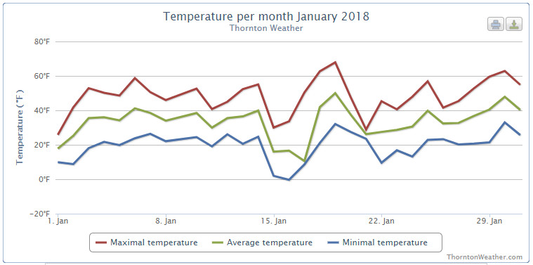
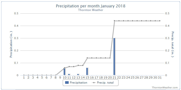
New Year’s Day started the month off cold but then we began a warming trend that saw average temperatures dominantly above normal for the first two weeks of the month. Precipitation was almost entirely absent during the period other than a bit of rain on the 10th.
On the 15th conditions like we expect in January returned – but only for two days. A quick, light shot of snow arrived and temperatures cooled to below normal.
We then returned to largely warmer than normal conditions until the 21st when we got not only our biggest snow of the month, but our biggest of the season so far. Sadly, that was only 4.9 inches of the white stuff.
From there, eight of the last ten days of the month saw above normal temperatures and no precipitation.
Thornton’s average temperature for January 2018 came in at 32.9 degrees. Denver’s long term average for the month is 30.7 degrees. Out at the airport where the Mile High City’s official measurements are taken, it was considerably warmer with an average of 34.7 degrees.
Our high temperatures ranged from a high of 69.3 degrees on the 9th down to a low of 0 degrees on the morning of the 16th. DIA recorded highs of 68 degrees and a low of -4 degrees on those same dates.
On average, Denver receives 0.41 inches of liquid precipitation in January. Thornton was just a hair above that with 0.44 inches and Denver bested that with 0.54 inches.
We recorded 6.1 inches of snow in Thornton during the month while the airport was just a bit higher with 6.4 inches. Both were short of Denver’s January average of 7.0 inches.
Click here to view Thornton’s January 2018 climate report.
CLIMATE REPORT
NATIONAL WEATHER SERVICE DENVER/BOULDER CO
650 AM MST THU FEB 1 2018

...................................

...THE DENVER CO CLIMATE SUMMARY FOR THE MONTH OF JANUARY 2018...

CLIMATE NORMAL PERIOD 1981 TO 2010
CLIMATE RECORD PERIOD 1872 TO 2018

WEATHER         OBSERVED          NORMAL  DEPART  LAST YEAR`S
                 VALUE   DATE(S)  VALUE   FROM    VALUE  DATE(S)
                                          NORMAL
................................................................
TEMPERATURE (F)
RECORD
 HIGH              76   01/27/1888
 LOW              -29   01/09/1875
HIGHEST            68   01/09        76      -8       63  01/30
LOWEST             -4   01/16       -29      25       -7  01/06
AVG. MAXIMUM     49.2              44.0     5.2     42.3
AVG. MINIMUM     20.1              17.4     2.7     17.7
MEAN             34.7              30.7     4.0     30.0
DAYS MAX >= 90      0               0.0     0.0        0
DAYS MAX <= 32      3               5.5    -2.5        8
DAYS MIN <= 32     28              29.4    -1.4       30
DAYS MIN <= 0       2               1.7     0.3        2

PRECIPITATION (INCHES)
RECORD
 MAXIMUM         2.35   1883
 MINIMUM         0.01   1933
                        1934
                        1952
TOTALS           0.54              0.41    0.13     0.54
DAILY AVG.       0.02              0.01    0.01     0.02
DAYS >= .01         5               4.1     0.9        3
DAYS >= .10         2               0.9     1.1        3
DAYS >= .50         0               0.0     0.0        0
DAYS >= 1.00        0               0.0     0.0        0
GREATEST
 24 HR. TOTAL    0.30   01/21 TO 01/21

SNOWFALL (INCHES)
TOTALS            6.4               7.0
RECORD
 MAX TOTAL       24.3   1992

DEGREE_DAYS
HEATING TOTAL     932              1063    -131     1075
 SINCE 7/1       3082              3531    -449     3117
COOLING TOTAL       0                 0       0        0
 SINCE 1/1          0                 0       0        0

FREEZE DATES
RECORD
 EARLIEST     09/08/1962
 LATEST       06/08/2007
EARLIEST                        10/07
LATEST                          05/05
.................................................................

WIND (MPH)
AVERAGE WIND SPEED              9.3
RESULTANT WIND SPEED/DIRECTION   4/193
HIGHEST WIND SPEED/DIRECTION    37/260    DATE  01/30
HIGHEST GUST SPEED/DIRECTION    48/270    DATE  01/30

SKY COVER
POSSIBLE SUNSHINE (PERCENT)   MM
AVERAGE SKY COVER           0.50
NUMBER OF DAYS FAIR            6
NUMBER OF DAYS PC             21
NUMBER OF DAYS CLOUDY          4

AVERAGE RH (PERCENT)     49

WEATHER CONDITIONS. NUMBER OF DAYS WITH
THUNDERSTORMS 0
HEAVY RAIN             2    MIXED PRECIP            3
LIGHT RAIN           0    RAIN                    1
LT FREEZING RAIN       0    FREEZING RAIN           0
HEAVY SNOW             3    HAIL                    0
LIGHT SNOW             0    SNOW                    7
FOG                    1    FOG W/VIS <=1/4 MILE    1
HAZE                   4

-  INDICATES NEGATIVE NUMBERS.
R  INDICATES RECORD WAS SET OR TIED.
MM INDICATES DATA IS MISSING.
T  INDICATES TRACE AMOUNT.
Thornton’s February weather preview: Typically a warmer, less snowy month
 February in Colorado typically brings to an end an extended period when average temperatures are at their lowest. Winter begins to loosen its grip and temperatures get warmer but precipitation is not a particularly common event during the month.
Thus far our snow season has been relatively dismal with the seasonal total in Thornton more than 10 inches below average. In the high country, the snowpack is not faring much better. February is only our sixth snowiest month so we may not see much snowfall for the balance of the month.
Temperatures however do usually see a nice rebound during the month. Average high temperatures climb from an average of 44 degrees at the start to 50 degrees by the end of February.
January 2018 top shots: Monthly photo slideshow

As one of our coldest months, January can be a good month to hibernate inside and avoid the outdoors. But, like any month in Colorado, photo opportunities abound as our monthly slideshow demonstrates.
Snow is not normally dominant in the month but when it does fall, it can create a beautiful blanket of white. Throw in the amazing sunrises and sunsets we receive in the middle of winter as well as wildlife and a host of other subjects and the imagery can be quite beautiful and stunning.
- Slideshow updated January 31, 2018
- To learn more about how to send your photo to us for inclusion in the slideshow, see below the slideshow.
Showcasing images captured by ThorntonWeather.com readers as well as some of our own, our monthly slideshow covers the entire gamut of weather-related imagery.
Sunsets, sunrises, wildlife and of course every type of weather condition are vividly depicted in images captured from yours and our cameras.
| [flickr_set id=”72157690622795841″] |
What is missing in the slideshow above? Your photo!
Our monthly photo slideshow is going to feature images that we have taken but more importantly images that you have captured. The photos can be of anything even remotely weather-related.
Landscapes, current conditions, wildlife, pets, kids. Whimsical, newsy, artsy. Taken at the zoo, some other area attraction, a local park, a national park or your backyard. You name it, we want to see and share it!
Images can be taken in Thornton, Denver or anywhere across the extraordinary Centennial State. We’ll even take some from out of state if we can tie it to Colorado somehow.
We’ll keep the criteria very open to interpretation with just about any image eligible to be shown in our slideshows.
What do you win for having your image in our slideshow? We are just a ‘mom and pop’ outfit and make no money from our site so we really don’t have the means to provide prizes. However you will have our undying gratitude and the satisfaction that your images are shared on the most popular website in Thornton.
To share you images with us and get them included in the slideshow just email them to us or share them with ThorntonWeather.com on any of the various social media outlets. Links are provided below.
So come on, get those camera’s rolling!
- Email: info@ThorntonWeather.com
- Facebook: https://www.facebook.com/ThorntonWeather
- Google+: https://plus.google.com/+Thorntonweather
- Twitter: @ThorntonWeather (https://twitter.com/thorntonweather)
Webcam captures the total lunar eclipse
Just in case you missed it, our west-facing weather webcam happened to catch the “super blood blue moon.” Certainly it isn’t as good as witnessing it in person but it does provide a cool look. You can see the shadow of the Earth clearly obscuring the moon as the event progresses. View full screen for the best view.
If you captured images of the celestial event, please share them with us so we can add them to our January slideshow.
90,000 flee Philippine volcano stretching relief camps
|
Rare ‘super blood blue moon’ visible on Jan 31
|
Volcanos, earthquakes: Is the ‘Ring of Fire’ alight?
|
Thousands more flee erupting Philippine volcano
|
Watch Beautiful Snow Tornado Blow Through a Picturesque Austrian Village
|