The silence from the Thornton PD has been deafening. As other Denver metro area police departments posted their lip sync challenge entry, we heard nothing from the local men and women in blue. That changed today.
Set to the song “Danger Zone” by Kenny Loggins and made famous in the movie Top Gun, the Thornton Police Department brings it all from cars to motorcycles to yes, even planes.
All in all, we have to say the video is worth the wait and probably the best we have seen from any local agency. Of course we are residents of Thornton and Navy veterans so we might be biased. 😉
August 12 to August 18: This week in Denver weather history
Denver’s weather calms considerably in August as compared to many other months but the history books show plenty of notable events in our past. Lightning, flooding rain and even a tornado highlight this week in Denver weather history.
8-13
In 1875…clouds of grasshoppers were seen flying through the air on the prevailing winds during each day.
12
In 1876…the temperature climbed to a high of 100 degrees in downtown Denver.
In 1941…excessive thunderstorm rainfall flooded streets and delayed traffic for a few hours in some sections of the city. The basements of a considerable number of homes and commercial buildings were flooded. The total value of the damage was unknown. Only 0.94 inch of thunderstorm rainfall was recorded downtown.
In 1969…a man and a 9-year old boy were injured…when lightning struck a tree near where they were standing. Both were revived after treatment…but the boy later died of respiratory failure due to electrical shock.
In 1984…heavy thunderstorm rains drenched southern metro Denver. Rural roads in Douglas County received minor washouts. Hail…as large as 3/4 inch in diameter…was reported in southeast Aurora with one inch diameter hail reported near Parker. Rainfall totaled 1.00 inch at Stapleton International Airport.
12-13 in 1975…heavy rains caused flash flooding along the foothills from Denver north. Thunderstorm rainfall totaled 1.56 inches at Stapleton International Airport.
In 2004…a brief cool spell resulted in two daily temperature records. The low temperature of 49 degrees was a record minimum for the 12th…as was the low temperature of 48 degrees on the 13th.
13
In 1959…thunderstorm winds gusted to 53 mph at Stapleton Airport.
In 1983…thunderstorms dumped torrential rain in Northglenn… Thornton…and Broomfield. Northglenn was drenched with 1.72 inches in 30 minutes. Street flooding was widespread. Hail…as large as 3/4 inch in diameter…was reported 7 miles northeast of Boulder along with heavy rain which caused some street flooding.
In 2000…lightning sparked 3 small grass fires near Golden. The fires were quickly contained. Hail as large as 3/4 inch in diameter fell in Castle Rock.
14
In 1960…a bolt of lightning struck a man in Henderson… Causing serious burns.
In 1962…the temperature climbed to a high of 100 degrees at Stapleton Airport.
In 1968…a young man on a golf course in Denver was injured when lightning struck a tree under which he was standing. Lightning caused minor damage to a house in Denver. Heavy thunderstorm rain caused local street flooding. One inch diameter hail fell at Jefferson County Airport near Broomfield.
In 1973…winds as high as 85 mph damaged 20 aircraft at the Arapahoe County airport…now centennial airport.
In 1977…three tornadoes were sighted in Bennett. A man suffered a broken leg when hit by a flying board. He was outside his camper home…which was destroyed. All windows were broken in a near-by farmhouse where some shingles were ripped off and a 2 car garage was knocked down. Several vehicles were damaged and a cat…some rabbits…and chickens were killed. A broken oar from a boat was driven into the side of a house. A mobile home was overturned. One old barn was destroyed. Half a dozen homes and several agricultural buildings were damaged just west of State Highway 79.
In 1978…high winds produced much blowing dust…causing many traffic accidents in the Denver-Boulder area. Winds gusts of 70 to 101 mph were recorded. Northwest winds gusted to 44 mph at Stapleton International Airport.
In 1980…lightning hit two power poles in Littleton…causing 400 dollars in damage. Rainfall of 1.23 inches in a short time caused minor flooding…which included damage to a ground floor apartment and partially submerging a few vehicles in water. Thunderstorm rainfall totaled 0.98 inch at Stapleton International Airport.
In 1983…2.10 inches of rain drenched Golden in an hour with similar amounts in Lakewood and Boulder. Over ten thousand dollars worth of plants were washed away at a nursery in Lakewood.
In 1997…twelve motorists were injured in a multi-car accident when strong microburst winds estimated to 50 mph blew blinding dust across I-70 near Bennett.
In 1998…lightning struck a hydro-electric plant in Nederland… Causing a power outage. Residents in the foothills west of Boulder…including Nederland…Ward…Eldora…Jamestown… And Gold Hill…were without power for about an hour.
In 2006…heavy thunderstorm rainfall near Deckers washed away some the banks along State Highway 67 between Deckers and Westcreek. Several driveways on both sides of the highway were also damaged.
15
In 1899…a thunderstorm produced southwest sustained winds to 43 mph with gusts to 46 mph.
In 1972…a pilot reported a funnel cloud briefly touching the ground in open fields…17 miles east-northeast of Stapleton International Airport.
In 1980…thunderstorm winds gusted to 55 mph in Boulder.
In 1982…brief heavy rain and winds estimated as high as 70 mph occurred in the conifer-Evergreen area. No damage was reported.
In 1990…lightning triggered a small attic fire in a house near Sedalia…20 miles south of Denver. A furious lightning storm caused widespread power outages across southern sections of metro Denver. One lightning bolt knocked out an electrical substation…causing a 90-minute blackout in southeast Denver affecting nearly 10 thousand homes and businesses.
In 2007…severe thunderstorms produced large hail…up to 2 inches in diameter…near larkspur. Extensive damage to vehicles in the area was reported.
In Parker…lightning struck a residence. The ensuing fire damaged the attic and top floor; causing $100000 in property damage.
In 2008…at least three homes were hit by lightning during the early morning hours in Arapahoe County. Lightning also struck two homes in Castle Rock…damaging the roofs.
In 2013…a dry microburst uprooted 30 to 40 large trees across a 12-block area of the Park Hill neighborhood in east central Denver. Several trees were snapped near the base along with numerous branches…8 to 10 inches in diameter. Power poles and lines were also downed with resulted in outages which affected seven hundred residents. One of the downed trees crushed a car`s hood… narrowly missing the driver. At Denver International Airport…a peak wind gust of 22 mph was observed from the southwest.
As summer vacations wind down and families prepare to send their kids back to school in August, Colorado weather also starts to settle down. The chances for severe weather decrease markedly during August and by the end of the month daytime temperatures are dropping quite a bit as well.
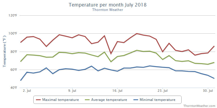
The month of July was somewhat a tale of two months in one. The first half was most notable for their unseasonably warm temperatures and relatively dry conditions. The second half saw a few days of heat but for the most part was considerably cooler and wetter.
Thornton saw an average temperature for the month of 73.5 degrees. Out at Denver International Airport where the Mile High City’s official readings are taken, the month saw an average of 75.3 degrees. Long term, the month of July sees an average of 74.2 degrees in Denver so while Thornton was cooler than that, Denver was warmer.
Thornton had its highest temperature reading of 99.9 degrees on the 19th and its coldest of 47.7 degrees on the 1st. Denver saw its warmest reading of 99 degrees on the 3rd and its coldest of 47 degrees on the 1st.
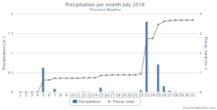
In terms of precipitation, Denver’s long term July average is 2.16 inches. Thornton easily bested that number with 3.66 inches in our rain bucket. The Mile High City fell well short with only 1.03 inches.
Thornton, Colorado’s July 2018 temperature summary. (ThorntonWeather.com)Thornton, Colorado’s July 2018 precipitation summary. (ThorntonWeather.com)
CLIMATE REPORT
NATIONAL WEATHER SERVICE DENVER/BOULDER CO
305 PM MDT WED AUG 1 2018

...................................

...THE DENVER CO CLIMATE SUMMARY FOR THE MONTH OF JULY 2018...

CLIMATE NORMAL PERIOD 1981 TO 2010
CLIMATE RECORD PERIOD 1872 TO 2018

WEATHER         OBSERVED          NORMAL  DEPART  LAST YEAR`S
                 VALUE   DATE(S)  VALUE   FROM    VALUE  DATE(S)
                                          NORMAL
................................................................
TEMPERATURE (F)
RECORD
 HIGH             105   07/20/2005
 LOW               42   07/04/1903
                        07/31/1873
HIGHEST            99   07/03        99       0      100  07/19
                                                          07/06
LOWEST             47   07/01        51      -4       51  07/01
AVG. MAXIMUM     90.2              89.4     0.8     91.5
AVG. MINIMUM     60.3              58.9     1.4     61.3
MEAN             75.3              74.2     1.1     76.4
DAYS MAX >= 90     19              16.0     3.0       20
DAYS MAX <= 32      0               0.0     0.0        0
DAYS MIN <= 32      0               0.0     0.0        0
DAYS MIN <= 0       0               0.0     0.0        0

PRECIPITATION (INCHES)
RECORD
 MAXIMUM         6.41   1965
 MINIMUM         0.01   1901
TOTALS           1.03              2.16   -1.13     0.47
DAILY AVG.       0.03              0.07   -0.04     0.02
DAYS >= .01         8               8.3    -0.3        6
DAYS >= .10         3               4.3    -1.3        3
DAYS >= .50         0               1.4    -1.4        0
DAYS >= 1.00        0               0.7    -0.7        0
GREATEST
 24 HR. TOTAL    0.43   07/23 TO 07/23

SNOWFALL (INCHES)
 TOTAL            0.0               0.0
RECORDS
 TOTAL            0.0

DEGREE_DAYS
HEATING TOTAL       0                 6      -6        0
 SINCE 7/1          0                 6      -6        0
COOLING TOTAL     326               289      37      360
 SINCE 1/1        615               444     171      533

FREEZE DATES
RECORD
 EARLIEST     09/08/1962
 LATEST       06/08/2007
EARLIEST                        10/07
LATEST                          05/05
.................................................................

WIND (MPH)
AVERAGE WIND SPEED              10.1
RESULTANT WIND SPEED/DIRECTION   2/138
HIGHEST WIND SPEED/DIRECTION    47/140    DATE  07/02
HIGHEST GUST SPEED/DIRECTION    64/150    DATE  07/02

SKY COVER
POSSIBLE SUNSHINE (PERCENT)   MM
AVERAGE SKY COVER           0.50
NUMBER OF DAYS FAIR           10
NUMBER OF DAYS PC             20
NUMBER OF DAYS CLOUDY          1

AVERAGE RH (PERCENT)     50

WEATHER CONDITIONS. NUMBER OF DAYS WITH
THUNDERSTORMS            13   MIXED PRECIP           0
HEAVY RAIN                3   RAIN                   5
LIGHT RAIN               11   FREEZING RAIN          0
LT FREEZING RAIN          0   HAIL                   0
HEAVY SNOW                0   SNOW                   0
LIGHT SNOW                0   FOG W/VIS <=1/4 MILE   3
FOG                       8   HAZE                   5

-  INDICATES NEGATIVE NUMBERS.
R  INDICATES RECORD WAS SET OR TIED.
MM INDICATES DATA IS MISSING.
T  INDICATES TRACE AMOUNT.
August 5 to August 11: This week in Denver weather history
As we enter August the weather typical is a bit calmer as the atmosphere settles down. However our look back at this week in Denver weather history shows that Mother Nature can still visit plenty of excitement on us.
From the National Weather Service:
5
In 1881…the low temperature cooled to only 76 degrees…the record high minimum temperature for the month.
In 1889…southwest winds were sustained to 42 mph.
In 1918…hail pelted the city…but was light and caused no damage. Precipitation totaled 0.25 inch. Northwest winds were sustained to 31 mph.
In 1964…lightning struck two boys in Denver while playing ball. One was treated and released from the hospital…but the other boy suffered second degree electrical shock and cardiac arrest and was hospitalized in critical condition for several days.
In 1969…two tornadoes touched down briefly in an open field southeast of Buckley Field in Aurora. No damage was reported.
In 1970…heavy rain in the Indian Hills area in the foothills west of Denver caused flash flooding…which washed out roads and damaged other property. Hail accumulated to a 3 inch depth with stones up to golf ball size; however…most of the damage was from flooding.
In 1982…2.38 inches of rain fell in an hour in Arvada… Causing minor flooding on Ralston Creek. In Westminster… 1 1/2 inches of rain fell…causing damage to streets and culverts. In addition…lightning caused some minor power outages across metro Denver.
In 1983…very heavy thunderstorms hit the southern portion of metro Denver. Heavy rainfall…as much as 2.89 inches in 38 minutes…caused widespread street flooding in southeast Denver. Two feet of water covered a section of I-25. Hail up to golf ball size accompanied the storm in Littleton and Englewood…along with 60 mph winds.
In 1984…a heavy thunderstorm drenched Littleton with up to 2.35 inches of rain in an hour…along with small hail that piled up to 2 inches deep. Flood waters were up to 4 feet deep in parts of town with many basements flooded. There were some power outages caused by lightning.
In 1990…a thunderstorm dumped 1.25 inches of rain in 12 minutes near tower and smoky hill roads in southeast Aurora. Minor street flooding was reported in the area.
In 1992…a pilot reported two funnel clouds near Cheery Creek Reservoir. Both dissipated quickly. Dime size hail fell near Franktown.
In 1994…one inch diameter hail fell near Strasburg. No damage was reported.
In 1999…a dog kennel east of Denver International Airport… Was flooded when a small dam…upstream in Elbert County… Was breached. The floodwaters…up to 4 feet deep…washed away some 6-foot fences and other small buildings. Ten of the 70 dogs boarded at the kennel drowned.
In 2002…a mail carrier was struck by lightning as he inserted a key into a multi-unit mailbox in Bailey. The shock knocked the man back against the mail truck. He suffered minor injuries. Lightning struck a residence in Commerce City. The resulting fire destroyed the roof of a detached garage and damaged much of its contents. Hail as large as 1 3/4 inches in diameter pelted pine. One inch diameter hail fell in Arvada and southwest Denver. Heavy rain triggered a mudslide along U.S. Highway 285 near Bailey. Both lanes of traffic had to be closed until debris could be removed from the highway. Several residences in the Bailey and Glenisle areas were also flooded.
In 2004…heavy thunderstorm rainfall caused localized flash flooding in Virginia canyon near Idaho Springs. Sections of the Virginia Canyon Road had to be closed due to the floodwaters.
In 2008…a severe thunderstorm produced large hail…up to 1 1/4 inches in diameter…northeast of Parker. Several automobiles were damaged.
6
In 1877…a severe rain…hail…and wind storm struck Denver. The storm produced a one minute sustained wind speed of 75 mph. Rainfall totaled 1.00 inch in 25 minutes. The hail storm damaged vegetable gardens in the city.
In 1954…an unconfirmed tornado was reported in Westminster. A funnel cloud was sighted in the area…but it was not certain if it had touched down. No damage was reported.
In 1980…the temperature reached 100 degrees…setting a new record high for the date.
In 1982…3/4 inch diameter hail was reported in north Denver. Heavy rain caused street flooding in central Denver where 4 to 5 feet of water inundated I-25…closing the freeway for a while. Rainfall across metro Denver ranged up to 2.35 inches in just over an hour. An estimated 2000 basements were flooded. Only 0.01 inch of rain fell at Stapleton International Airport.
In 1991…heavy rain caused flooding at the junction of I-25 and I-70. Dime size hail was reported northeast of Boulder near Niwot.
In 1995…microburst winds gusting as high as 58 mph caused minor damage to an apartment complex in Broomfield. Some homes under construction were also damaged when the winds knocked over 2 by 4 wood beams along with some insulation and roofing materials…which broke a few windows. Microburst winds also overturned a camper near Barr Lake.
In 1996…hail ranging in size from 1 to 1 1/2 inches fell near Bennett.
In 2001…3/4 inch hail fell in the foothills near conifer.
In 2008…a record daily rainfall record was set at Denver International Airport. The record of 1.29 inches in 24 hours broke the previous record of 1.10 inches set in 1929.
7
In 1948…a brief west moving tornado was sighted 3 miles north-northeast of Stapleton Airport. The white funnel silhouetted against a gray cloud background was very narrow…nearly vertical…and estimated at nearly 5 thousand feet high. A dust cloud formed on the ground around the funnel. No damage was reported.
In 1952…a thunderstorm wind gust to 52 mph was recorded at Stapleton Airport.
In 2014…severe thunderstorms produced large hail across western and southern parts of metro Denver. Near Centennial and Golden…hail up to quarter size was reported. Near Bennett…a peak thunderstorm wind gust to 65 mph was also reported. At Denver International Airport…a peak wind gust to 46 mph was recorded.
8
In 1874…swarms of grasshoppers invaded the city. Millions of them were seen cruising through the air. The insects were apparently picked up by a thunderstorm gust front and carried into the city. The grasshoppers had ravaged crops in surrounding counties for the last month.
In 1878…the highest temperature ever recorded in Denver…105 degrees…occurred at 3:20 pm. This temperature was equaled on July 20th in 2005.
In 1969…the temperature reached 100 degrees at Stapleton International Airport.
In 1976…in Thornton…a 13 year old boy riding a bicycle was struck and killed by lightning.
In 2000…lightning struck three homes in central Arapahoe County east of Denver. Damage was estimated at 47 thousand dollars.
In 2003…hail to 1 inch in diameter pelted Denver. Hail to 7/8 inch was measured in Boulder.
In 2008…heavy rain also caused flash flooding over south Denver and its nearby suburbs. Heavy rain…from 2.5 to 4 inches…fell in less than 90 minutes. Firefighters rescued 20 people as the water quickly rose along creeks…flooded roadways…and stranded motorists. Three people had to be rescued along Cherry Creek when the bike path flooded.
In Evergreen…a man suffered minor injuries when he was struck by lightning. It entered his finger…traveled down his body… And exited his foot.
In 2013…heavy rain caused localized flash flooding in Aurora. An undergound parking garage at an apartment complex was inundated with 3 to 4 feet of water. Flash flooding forced a road closure at East Mississippi Ave. and Alton St. Also… several people had to be rescued when three vehicles stalled in floodwaters at Alameda Ave. and Havana St. The stationary thunderstorms dumped 2.75 inches of rain in less than 45 minutes. In addition…large hail…up to one inch in diameter…was reported north of Roxbourough State Park. At Denver International Airport…just a trace of rainfall was observed.
Smoke from area wildfires helps color the sky orange at sunrise. (Jessica Fey)
Colorado offers outdoor opportunities unlike any other state and while the summer heat settles in, photos of the amazing scenes across our state provide a view into why we love it here so much.
The weather this time of year has a pretty standard pattern of quickly warming temperatures followed by afternoon thunderstorms that can cool things down. These storms sometimes provide a good bit of ‘excitement’ and are a prime photo subject.
Slideshow updated July 29, 2018
Recreationalists head outdoors and take advantage of urban, suburban and rural opportunities. As they do, our abundant wildlife that is found just about anywhere comes into focus.
Showcasing images captured by ThorntonWeather.com readers as well as some of our own, our monthly slideshow covers the entire gamut of weather and nature related imagery. Sunsets, sunrises, wildlife and of course every type of weather condition are vividly depicted.
To learn more about how to send your photo to us for inclusion in the slideshow, see below the slideshow.
[flickr_set id=”72157697199001551″]
What is missing in the slideshow above? Your photo!
Our monthly photo slideshow is going to feature images that we have taken but more importantly images that you have captured. The photos can be of anything even remotely weather-related.
Landscapes, current conditions, wildlife, pets, kids. Whimsical, newsy, artsy. Taken at the zoo, some other area attraction, a local park, a national park or your backyard. You name it, we want to see and share it!
Images can be taken in Thornton, Denver or anywhere across the extraordinary Centennial State. We’ll even take some from out of state if we can tie it to Colorado somehow.
We’ll keep the criteria very open to interpretation with just about any image eligible to be shown in our slideshows.
What do you win for having your image in our slideshow? We are just a ‘mom and pop’ outfit and make no money from our site so we really don’t have the means to provide prizes. However you will have our undying gratitude and the satisfaction that your images are shared on the most popular website in Thornton.
To share you images with us and get them included in the slideshow just email them to us or share them with ThorntonWeather.com on any of the various social media outlets. Links are provided below.
Time for a break! We’ll be largely incommunicado for a few days while getting some much-needed R & R. The good thing is that the weather looks to be relatively calm while we are gone. As always, keep an eye on our website for all the latest including real-time conditions, forecasts, and much more.
July 29 to August 4: This week in Denver weather history
The effects of our annual monsoon season are portrayed in detail in our look back at this week in Denver weather history. Numerous cases of flooding resulting from heavy rainfall are seen as are other severe weather events including hail and even tornadoes.
From the National Weather Service:
13-5
In 2008…a streak of 24 consecutive days of 90 degrees shattered the previous record of 18 consecutive days established in 1901 and 1874. Ironically…no new single day record high temperatures were set in the month of July. In August however…a record of 104 degrees was set on the 1st…and another record of 103 degrees was set on the 2nd. In addition…a record low min of 70 degrees was set on August 2nd.
18-2
In 1987…a streak of 16 consecutive days of 90 degrees ranked 4th on the list of hot streaks. The record of 24 consecutive days was established in the summer of 2008.
27-31 in 1956…96 percent of the total precipitation for the month of July occurred over the last five days of the month. Heavy thunderstorms produced 4.00 inches of rainfall at Stapleton Airport. This amount of precipitation in 5 days or less had been exceeded only 3 times in previous record. The last time had been in December of 1913 as snow. Considerable property damage occurred across metro Denver from flooding.
28-30
In 1889…dense smoke from forest fires in the mountains obscured the sun over the city for three days.
In 1971…a vigorous cold front late on the 28th produced northeast wind gusts to 39 mph and record breaking cold temperatures on the 29th and 30th. The temperature dipped to 47 degrees on the 29th and 43 degrees on the 30th… Setting record minimums for the dates. Upslope cloudiness along with rain and fog early on the 29th helped set a record low maximum temperature of 58 degrees for the date.
29
In 1878…a total eclipse of the sun was observed at 2:20 pm. From before to during the eclipse…the temperature in the sun fell from 114 degrees to 82 degrees…while the shade temperature fell from 89 degrees to 83 degrees.
In 1880…heavy thunderstorm rain and hail flooded streets and ditches.
In 25 minutes…0.76 inch of rain fell on the city along with large hail to 3/4 inch in diameter. There were no strong winds with the storm.
In 1890…a thunderstorm produced sustained west winds to 48 mph with gusts to 60 mph…but only 0.01 inch of rain.
In 1956…heavy rain and hail fell over west and north Denver.
In 1964…hail to 3/4 inch in diameter fell at Lowry Airfield.
In 1978…a small tornado was sighted just east of Parker. No damage was reported.
In 1989…heavy rain drenched all areas of the Front Range… Both in the foothills and adjacent plains. Amounts of 1 to 3 inches were general over the area. Damage was confined to a few minor road washouts and some street…basement…and crop flooding. Thunderstorm rainfall totaled 1.44 inches at Stapleton International Airport where north winds gusted to 43 mph. Lightning struck a 250 thousand dollar home near Nederland and started a fire which destroyed all of it except two garages. Lightning started a fire in a home in Evergreen. It reached the house by hitting a tree…then traveling through a metal clothesline strung between the tree and the building.
In 1995…thunderstorm winds gusted to 59 mph in Brighton. Thunderstorm winds from the south-southeast gusted to 41 mph at Denver International Airport. High temperature of 99 degrees was a new record maximum for the date in Denver.
In 1997…heavy rain caused flooding in an apartment building in Westminster. Several residents had to be evacuated from their apartments. A woman in aspen park received minor injuries…when lightning passed through an office window and struck her. She suffered temporary blindness for about 15 minutes.
In 2003…hail as large as 1 inch in diameter pelted Conifer… Highlands Ranch…and Franktown.
29-30
In 1997…heavy rain caused flooding and flash flooding in central portions of Adams and Arapahoe counties. Two homes were extensively damaged when water flooded the basements and adjacent pasture area in Strasburg. Water 4 to 5 feet deep had pooled in the lower lying areas of the town. A portion of Quincy Road was closed in Arapahoe County when 4 feet of water covered the roadway. Rainfall totaled 3.06 inches at Denver International Airport…establishing a new record for 24-hour rainfall in July. The previous record was 2.42 inches set in 1965 on the 24th and 25th.
30
In 1879…lightning struck a brick kiln in north Denver. Three men were knocked senseless…but all recovered. Rainfall in the city was only 0.09 inch.
In 1881…a thunderstorm dumped heavy rain and hail on the city…causing street flooding and much damage. A heavy torrent of rain fell with 1.10 inches measured in just 20 minutes. Storm total rainfall was 1.60 inches. The rain turned streets into running streams. Wood street crossings were torn up and washed away. The storm caused great damage by flooding many cellars where goods were stored. The brick yards suffered severe damage when the heavy rainfall destroyed many unfired bricks.
In 1913…northeast winds were sustained to 41 mph with gusts to 48 mph.
In 1939…a thunderstorm produced 0.08 inch of rainfall. This was the only measurable precipitation of the month…making the month the second driest July on record.
In 1961…heavy rain and lightning disrupted power lines and caused flooding in Denver. Thunderstorm rains totaled 1.60 inches at 11th and Lincoln in central Denver.
In 1972…the temperature climbed to a high of 100 degrees at Stapleton International Airport.
In 1983…hail 3/4 to 1 inch in diameter fell in central and southeast Denver and in Littleton. Rainfall of 1.50 inches occurred in just 30 minutes in Littleton. There was some street flooding in both cities with wind gusts up to 55 mph.
In 1984…central Aurora was hit by a downpour that produced 1.80 inches of rain and sent water 2 to 3 feet deep into some streets. Before the rain stopped later in the evening… The storm had dropped as much as 2.80 inches of moisture on the city. Thunderstorm rainfall totaled only 0.82 inch at Stapleton International Airport.
In 1985…a tornado was spotted in open country 10 miles southwest of Bennett. No damage was reported. One inch hail was reported in south Lakewood.
In 1997…one man was killed and his girlfriend critically injured when they were struck by lightning on the Kennedy Golf Course in southeast Denver. Both were struck in the head when they took refuge under a tree during a downpour. Lightning struck a home in unincorporated Arapahoe County east of Buckley Field. The fire started in the electrical panel boxes…causing extensive damage to the home. Heavy rain and hail triggered a flash flood in Boulder…which sent water through a window of the financial aid office on the University of Colorado campus. In addition…ceiling tiles…carpets…and dressing rooms were damaged at the Coors Events Center when a pipe draining rainwater broke during the downpour. In all…10 buildings on the campus received water damage estimated at 100 thousand dollars. Hail as large as 1.25 inches in diameter accompanied the heavy rain in Boulder. Thunderstorm rainfall totaled 2.71 inches at Denver International Airport where west winds gusted to 41 mph. This was the greatest calendar day official precipitation ever recorded in July.
In 1998…heavy rain…up to 3 inches in an hour…caused flash flooding problems from Castle Rock to Parker. I-25 north of Castle Rock was closed as high waters covered sections of the highway. Some cars were left floating in the flood waters.
In 2001…a severe thunderstorm produced a wind gust to 70 mph at a wind sensor on the northeast corner of Denver International Airport.
In 2004…a severe thunderstorm produced wind gusts to 71 mph in Evergreen.
In 2005…the temperature climbed to a high of 101 degrees at Denver International Airport. This was a new record maximum temperature for the date.
In addition…this was the 7th day of the month with a high temperature of 100 degrees or more…which set a new Denver record for the most 100 degree days in a month…for a season…and in a year.
31
In 1873…the all-time lowest recorded temperature in July… 42 degrees…occurred. The same temperature also occurred on July 4…1903.
In 1874…during the late afternoon rain and hail fell for 5 minutes followed by brief heavy rain. Pieces of solid ice of irregular shape fell upon the roof of the station. The hail stones measured 1 1/2 inches in diameter. Precipitation (rain and melted hail) was only 0.16 inch.
In 1889…the high temperature climbed to 100 degrees in downtown Denver.
In 1919…heavy thunderstorm rainfall totaled 2.59 inches in downtown Denver during the evening. Rainfall was 1.90 inches in an hour…a new record at that time.
In 1961…over an inch of rain in a short period of time caused flooding of streets and basements in Denver. Rainfall totaled 1.30 inches at 11th and Lincoln in central Denver.
In 1964…the temperature reached 91 degrees in Denver…making this the 27th day of the month that the temperature reached 90 degrees or more. This is the all time record for 90 degree days in a month in Denver.
In 1972…one inch diameter hail fell in Hudson northeast of Denver.
In 1976…during the evening hours extremely heavy thunderstorm rains produced flash flooding in Big Thompson Canyon which killed 144 people between Estes Park and Loveland. No significant weather occurred in metro Denver at the time.
In 1987…1 inch diameter hail fell in Lakewood and 3/4 inch hail fell near Louisville. Southeast Boulder County was drenched with 1.25 inches of rain in just 20 minutes.
In 1993…thunderstorm winds damaged a chimney of a home near Parker.
In 1996…a weak tornado (f0) was sighted 12 miles east of Denver International Airport. No damage was reported.
In 1998…heavy monsoonal thunderstorm rain triggered a mud slide in Blackhawk. The mudslide blocked Main St. and caused an estimated half million dollars in damage to a casino. Heavy thunderstorm rain…up to 3 inches in an hour…caused a flash flood along Buffalo Creek. Portions of County road 126 just south of the town of Buffalo Creek were washed out. The flood waters nearly washed away the bridge as mud and debris slammed into the structure. Hail to 1 3/4 inches in diameter fell near Idaho Springs.
In 2004…severe thunderstorm winds toppled a 65-foot blue spruce tree in Parker. The tree landed on a home damaging the roof and gutters. The downed tree poked dozens of holes into the shingles.
In 2013…severe thunderstorm winds…with gusts estimated to 80 mph…downed power poles which caused scattered outages in and around Byers…Bennett and Strasburg. Some property damage was also observed. Near Byers…aluminum siding and roofing was peeled off sheds. Large hail…up to one inch in diameter…was reported north of Bennett. At Denver International Airport… a peak wind gust to 40 mph was observed from the northeast.
July 22 to July 28: This week in Denver weather history
As we near the end of July the weather in Denver tends to be a bit more stable. That doesn’t mean the severe weather threat disappears as can be seen at our look back at this week in Denver weather history. Particularly notable are lightning injuries and deaths, flash flood events and even tornadoes.
From the National Weather Service:
7-25
In 1934…a streak of 15 consecutive days of 90 degrees ranked 5th on the list of hot streaks. The record of 24 consecutive days was established in the summer of 2008.
13-5
In 2008…a streak of 24 consecutive days of 90 degrees shattered the previous record of 18 consecutive days established in 1901 and 1874. Ironically…no new single day record high temperatures were set in the month of July. In August however…a record of 104 degrees was set on the 1st…and another record of 103 degrees was set on the 2nd. In addition…a record low min of 70 degrees was set on August 2nd.
18-2
In 1987…a streak of 16 consecutive days of 90 degrees ranked 4th on the list of hot streaks. The record of 24 consecutive days was established in the summer of 2008.
19-23
In 2005…the high temperature climbed above 100 degrees on each of the 5 days with readings of 101 on the 19th…105 on the 20th…104 on the 21st…and 102 on both the 22nd and 23rd. A new record maximum temperature for the month of July of 105 degrees was set on the 20th…which also equaled the all time record maximum for Denver of 105 degrees first set on August 8th in 1878. Daily maximum temperature records were set on each day…and the 5 day period equaled the record for the most consecutive days of 100 degrees or more first set from July 4th through 8th in 1989. The intense heat resulted in a high use of electricity for cooling purposes. The demand for electric power exceeded the supply and rolling black-outs… Each lasting about an hour…were scheduled across metro Denver during the afternoons and early evenings.
20-23
In 1961…unusually cool weather for July resulted in several temperature records. Record minimum temperatures were set or equaled on each day with readings of 51…51…49… And 49 degrees. High temperature of only 64 degrees on the 21st was a record low maximum for the date.
20-25
In 1965…heavy showers and thunderstorms doused metro Denver with significant rain each day. Rainfall for the six days totaled 5.16 inches at Stapleton International Airport. Massive rainfall occurred on the 20th…21st…and 25th… Flooding streets and basements and causing streams to overflow. The heaviest rainfall…2.05 inches…at Stapleton International Airport occurred on the 25th.
22
In 1874…a severe thunderstorm during the late afternoon produced 1.36 inches of rainfall in an hour…most of which fell in 20 minutes. There was much damage from flooding of streets and considerable damage to private property. The lightning was brilliant and continuous during the storm. Seven buildings were struck by lightning in the city…in addition to many places where it struck only the ground. A magnificent example of ball lightning was observed. When about 200 feet above the house tops…the ball exploded and broke into 7 or 8 different balls…each about 6 inches in diameter. Upon reaching about 20 feet above the ground…these balls broke into small fragments about 3 inches long and 1/2 inch wide. A shed situated in an alley about one block away was literally covered with these sparks. After the storm was over…the shed and adjacent area showed no trace of the event. Not the slightest mark could be detected on structures or on the ground.
In 1879…a terrific electrical storm passed over the city during the afternoon. The lightning display was unusually vivid and the crash of thunder seemed at the very house tops. A few homes and buildings were struck by lightning. A home on Capitol Hill sustained much damage to furniture… But the residents in another wing of the house were not injured. Lightning struck a fence at the corner of Curtis and Broadway. A lightning bolt stunned a workman and knocked a mason’s trough from his hand. A school was struck but was not damaged. Lightning struck the ground near tenth and Colfax. Rain fell in torrents for a time…but the heaviest was on the outskirts of the city. Rainfall in the city was only 0.30 inch.
In 1882…lightning struck and killed a man in the northern part of the city.
In 1895…heavy rainfall of 1.53 inches was measured in downtown Denver.
In 1931…the high temperature reached 100 degrees in downtown Denver.
In 1965…lightning struck and killed a boy standing by an automobile near Stapleton International Airport. Scattered heavy showers accompanied by hail and wind occurred across metro Denver. Heavy rain caused some street damage in Commerce City.
In 1973…minor thunderstorm wind damage was reported in Aurora.
In 1983…heavy thunderstorms dumped torrential rain and large hail across metro Denver. The most serious problems were caused by heavy rainfall in the foothills…which produced flooding on bear creek. Runoff from 3 inches of rain in 45 minutes at Kittredge caused bear creek to rise 5 feet in 10 minutes at Morrison…washing out two bridges. One bridge collapsed…plunging a fire truck into the water…but the occupants were not injured. The town was evacuated for 2 hours. Evergreen was drenched with 2.61 inches of rain in 30 minutes…which caused street flooding along with power outages. Hail to golf ball size damaged cars. A deck on a house east of Evergreen was washed away. At Idaho Springs… 2 inches of rain fell in 45 minutes. Golden received 3 inches of rain in an hour with 0.80 inch of rain in seven minutes at Littleton. Heavy rain and large hail also fell in the city of Denver and its northern and eastern suburbs… Causing street flooding. Water was 6 feet deep on one Aurora street.
In 1991…heavy rains caused extensive flooding across north metro Denver. Ralston creek in Arvada flowed out of its banks. At the intersection of I-25 and I-70…up to 8 feet of water covered the highway. A foot of water covered a stretch of I-70 in northwest Denver. Thunderstorm rainfall totaled only 0.82 inch at Stapleton International Airport.
In 1998…lightning sparked a fire which caused extensive damage to a home in Englewood. Most of the second floor was destroyed.
In 2004…severe thunderstorms produced hail to 1.25 inches in diameter in Commerce City and near Brighton.
22-23
In 1991…heavy rains over the palmer divide and along the Front Range caused the South Platte River to flood from near Henderson to Fort Lupton. The river was out of its banks at several locations with water covering the roads through the night. Only minor damage was reported.
With 1.80 inches having fallen in the bucket yesterday afternoon and evening, Thornton saw a big boost in our rainfall totals for July and the entire year.
In fact, the 1.80 inches from that one storm was more precipitation than we had seen in any single month yet this year.
It did push the month’s rainfall total to above the 11 year average for July however, for 2018 we are still lagging almost 2 inches below what we would normally see by the end of July.
There are still seven days left in the month and monsoonal flow does look to be present in the coming days so we certainly could see things improve further.