Wildlife is still quite active along the Front Range and flowers will hold on to their petals for at least the first part of the month. Then of course there is the weather which you never know what to expect. Thunderstorms, heavy rain, and even snow are a possibility.
Slideshow updated September 30, 2018
To learn more about how to send your photo to us for inclusion in the slideshow, see below the slideshow.
Showcasing images captured by ThorntonWeather.com readers as well as some of our own, our monthly slideshow covers the entire gamut of weather-related imagery.
Sunsets, sunrises, wildlife and of course every type of weather condition are vividly depicted in images captured from yours and our cameras.
[flickr_set id=”72157700963292955″]
What is missing in the slideshow above? Your photo!
Our monthly photo slideshow is going to feature images that we have taken but more importantly images that you have captured. The photos can be of anything even remotely weather-related.
Landscapes, current conditions, wildlife, pets, kids. Whimsical, newsy, artsy. Taken at the zoo, some other area attraction, a local park, a national park or your backyard. You name it, we want to see and share it!
Images can be taken in Thornton, Denver or anywhere across the extraordinary Centennial State. We’ll even take some from out of state if we can tie it to Colorado somehow.
We’ll keep the criteria very open to interpretation with just about any image eligible to be shown in our slideshows.
What do you win for having your image in our slideshow? We are just a ‘mom and pop’ outfit and make no money from our site so we really don’t have the means to provide prizes. However you will have our undying gratitude and the satisfaction that your images are shared on the most popular website in Thornton.
To share you images with us and get them included in the slideshow just email them to us or share them with ThorntonWeather.com on any of the various social media outlets. Links are provided below.
September 23 to September 29: This week in Denver weather history
While typically the last week of September is calm, that isn’t always the case. In our look back at this week in Denver weather history we see damaging wind, dangerous lightning and September’s biggest snowfall on record in the Mile High City.
From the National Weather Service:
23
In 1873…north to northwest winds blowing almost a gale spread clouds of dust and sand into the city during the afternoon and evening. From the roof of the weather observer’s building…houses a few hundred yards away were not visible and not even the sky could be seen through the clouds of sand. The wind reached sustained speeds of 35 mph…but only 28 mph was registered for any one hour.
In 1977…wind gusts from 50 to 80 mph were reported along the foothills. A northwest wind gust to 53 mph was recorded at Stapleton International Airport.
23-24
In 2000…the first snowstorm of the season brought heavy snow to areas in and near the foothills. While the heaviest snow fell north of metro Denver…6 inches were measured in Boulder…4 inches at both Castle Rock and Morrison…but only 0.2 inch at the site of the former Stapleton International Airport where most of the precipitation fell as rain. At Denver International Airport where drizzle and rain fell on the 23rd… Snowfall during the early morning of the 24th was estimated at 2.1 inches due to melting. The foothills west of Denver received more snow with 10 inches measured at conifer…9 inches 11 miles southwest of Morrison… 8 inches atop Crow Hill…7 inches at Chief Hosa…and 5 inches at Ralston Reservoir.
24
In 1901…northwest winds were sustained to 50 mph with gusts as high as 57 mph in the city.
In 1932…thunderstorm rainfall of only 0.11 inch was the only measurable precipitation for the month that year in the city.
In 1986…a very strong wind storm roared across metro Denver. Boulder was hit hardest. Winds peaked to 131 mph at the National Center for Atmospheric Research. This is thought to be the highest wind gust ever recorded in Boulder during September. A wind gust to 118 mph was clocked on Davidson Mesa and to 92 mph near Niwot. Gusts of 70 to 80 mph were common over all of Boulder where an estimated 70 to 90 large trees were uprooted. About a dozen of them hit cars. Two walls of a building under construction were toppled and solar panels were blown off a house. Traffic lights and power lines were downed. Damage to power equipment alone was estimated at 100 thousand dollars. Wind gusts to 87 mph at Jefferson County Airport damaged two planes. A woman was seriously injured in Boulder. She suffered a fractured skull when struck by a falling tree limb. Trees were also downed in Louisville and Lafayette. West wind gusts to 45 mph were recorded at Stapleton International Airport.
Rocky Mountain National Park is a prime spot for viewing the fall foliage. (Tony’s Takes)
This time of year many folks start thinking about heading to the hills west of Denver in search of gold – fall foliage gold.
Where to go? Below are five of ThorntonWeather.com’s favorite ones near Denver – plus a few further out and some bonus ideas. After that, we will tell you where you can find a great website that provides regular updates on viewing conditions.
I-70 Corridor – If you’re looking for the easiest route, then this one is for you. Simply head west on I-70 about 110 miles to Avon. Between Vail and Avon, both sides of I-70 are lined beautifully with aspen.
Rocky Mountain National Park – One of the most popular summer destinations in the state is of course also a prime spot to view aspen in all their glory. Once in the park head toward Bear Lake. Glacier Gorge Junction provides a beautiful spot and you of course also get to enjoy all the splendor that Rocky Mountain National Park has to offer. Extend your viewing by taking Trail Ridge Road all the way through to the west side of the park and the Grand Lake and Granby area.
Peak to Peak Highway – This little road trip can be a dual purpose trip – gambling and fall foliage viewing! Take U.S. 6 through Clear Creek Canyon and then 119 through Blackhawk and Central City. You can of course stop there if your wallet is fat enough and donate some money to the casinos. From there continue on 119 toward Nederland. Take highway 72 toward Ward and Allenspark. There you will find more golden aspen than you can imagine, all with the Continental Divide nearby.
Colorado Fall Foliage – Average Date of Peak Aspen Colors. Click for larger view. (ThorntonWeather.com)
Poudre Valley Canyon – Heading north on I-25 take Colorado 14 west and into Poudre Canyon and Roosevelt National Forest. As you continue west you will come very near timberline as you come to Cameron Pass. Amazing views abound!
Guanella Pass – This is a nice, relatively short drive from Denver. From C470 take 85 through Bailey and Conifer, a nice drive unto itself. When you come to the town of Grant, take the Guanella Pass Scenic and Historic Byway north to Georgetown. The air is pretty thin along the way as you climb in excess of 11,500 views through the Pike and Arapahoe National Forests.
A couple other possibilities further from the Front Range:
Leadville / Aspen – From Denver take I-70 west to Copper Mountain and then Colorado 91 south over Freemont Pass to Leadville. Along the way there are plenty of viewing opportunities and Leadville is a nice little town to make a stop. From here you can take Highway 24 north back through Minturn and Vail. To extend the drive, take Highway 24 south to Colorado 82 and head toward Aspen. You can stop by the Maroon Bells in White River National Forest to view some of the most photographed mountains in Colorado.
Cottonwood Pass – From Denver take Highway 285 to Buena Vista. Head west on Main Street for seven miles then west on County Road 344 / Colorado 82. From there you start the climb up Cottonwood Pass with absolutely stunning views from the top. If you are up for it, you can continue down the west side of the pass into the Taylor Park area. Be forewarned though that the western half of the pass is unpaved and twisty. Editor’s note: The west side of Cottonwood Pass is closed until sometime this fall so that it can be paved.
Honorable mentions worth considering:
Boreas Pass between Breckenridge and Como (County Road 10)
Kenosha Pass on Highway 285 between Bailey and Fairplay
Independence Pass (Colorado 82 between Aspen and Twin Lakes)
Colorado 103 from Evergreen to Echo Lake. Throw in a drive up Mount Evans for a bonus.
If you do head out, be sure to send us your pictures for inclusion in our monthly photo slideshows!
September 16 to September 22: This week in Denver weather history
Given our hot summer some may enjoy a look at what at times has been a cold and snowy week in Denver weather history. Not only one but two major snowstorms have occurred, both very damaging and both brought snowfall amounts we typically see in March, not September.
11-16
In 2013…a deep southerly flow over Colorado… Ahead of a nearly stationary low pressure system over the great basin… Pumped copious amounts of monsoonal moisture into the area. In addition…a weak stationary front stretched along the Front Range foothills and Palmer Divide. This resulted in a prolonged period of moderate to heavy rain across the Front Range foothills…Palmer Divide…urban corridor. By the 14th…storm totals ranged from 6 to 18 inches… Highest in the foothills of Boulder County. The headwaters then moved down the South Platte River and caused widespread flooding with record flood stages at several locations as it made its way downstream. The record high flood stages resulted in widespread flooding along the South Platte River basin. The flood damage encompassed 4500 square miles of the Front Range…left 7 dead… Forced thousands to evacuate…and destroyed thousands of homes and farms. Record amounts of rainfall generated flash floods that tore up roads and lines of communication… Leaving many stranded. Nearly 19000 homes were damaged… And over 1500 destroyed. Colorado department of transportation estimated at least 30 state highway bridges were destroyed and an additional 20 seriously damaged. Preliminary assessments of the state`s infrastructure showed damage of $40 million to roads and $112 million to bridges. Repair costs for state and county roads ran into the hundreds of millions of dollars. Miles of freight and passenger rail lines were washed out or submerged… Including a section servicing Amtrak`s iconic California Zephyr. The town of Lyons was isolated by the flooding of St. Vrain creek…and several earth dams along the Front Range burst or were over-topped. Floodwaters swept through Estes Park; damaged hundreds of buildings and destroyed large sections of U.S. 34 from Loveland and U.S. 36 from Lyons to Boulder. U.S. 34 suffered the most damage… With 85 percent of its roadway and bridges destroyed. In Weld County…about nearly two thousand gas wells were damaged and had to be closed off as the floodwaters inundated entire communities. Sewage treatment plants and other utilities were knocked out in a number of towns. Governor Hickenlooper declared a disaster emergency on September 13th…in 11 counties across northeast Colorado including: Adams…Arapahoe…Broomfield…Boulder…Denver… Jefferson…Larimer…Logan…Morgan… Washington and Weld. By the 15th…federal emergency declarations covered those counties as well as Clear Creek County. Projected losses from the flooding statewide was nearly two billion dollars in property damage…according to Eqecat… A catastrophe modeling firm. The damage was most severe in and around Lyons and Boulder. More than 11 thousand people were evacuated…reportedly the largest since Hurricane Katrina. President Obama declared a state of emergency for Boulder and Larimer counties. An additional 10 counties were added on the 16th and included: Adams… Arapahoe…Broomfield…Clear Creek…Denver…Jefferson… Morgan…Logan… Washington and Weld counties. The president also declared a major disaster specifically for Boulder County. There were six fatalities directly attributed to flash flooding. Two 19-yr old teenagers died on the 11th…after they were swept away by floodwaters after abandoning their car on Lindon Drive in Boulder. In Jamestown…a 72-yr old man was killed when the building he was in collapsed. An 80-yr old Lyons resident died in the early morning hours of the 12th…when his truck was swept into the St. Vrain River near his home. Later on the 12th…a 79-yr old Larimer County resident was killed when she was swept away while trying to climb to safety from her home in Cedar Point. A 61-yr old cedar point resident died when her home was swept down the Big Thompson River by the floodwaters. An 80-yr old Idaho Springs resident drowned in Clear Creek when the embankment he was standing on collapsed. In Boulder…some of the monthly records broken included: one-day all-time record: 9.08 inches which shattered the previous wettest day of 4.8 inches set on July 31… 1919; one-month record of 18.16 inches…which broke the previous all-time monthly record of 9.59 inches set in May of 1995; wettest September on record which broke the previous record of 5.5 inches set in September of 1940; one-year record of 34.15 inches broke the previous wettest year of 29.93 inches set in 1995. At Denver International Airport…the total precipitation for the month of September was 5.61 inches…which was 4.65 inches above the normal of 0.96 inches. This is the most precipitation ever recorded in Denver for the month of September. Daily precipitation records included 1.11 inches on the 12th and 2.01 inches on the 14th.
15-17
In 2000…unusually hot weather for so late in the season occurred when temperatures climbed into the 90’s setting daily record maximum temperatures on each of the 3 days. The high temperature was 92 degrees on the 15th and 95 degrees on both the 16th and 17th.
15-19
In 1906…rain on 5 consecutive days totaled 1.61 inches. A thunderstorm occurred on the 17th. High temperatures ranged from 48 degrees on the 16th to 65 degrees on the 15th. Low temperatures were in the lower to mid 40’s.
16
In 1874…a blast of west winds caused minor injuries during working hours in Boulder.
In Denver…the winds veered suddenly from the southwest to the northwest around noon and increased to a maximum sustained speed of 49 mph behind an apparent cold front. The winds remained strong and backed to the west for the remainder of the afternoon.
In 2000…the record high temperature of 95 degrees at Denver International Airport established or equaled 3 different record extremes: the high temperature broke the previous record high for the day of 92 degrees set over a century ago in 1895; it marked the warmest that it has been so late in September; it also marked the 60th day during the warm season that the temperature had reached 90 degrees or more…equaling the record first set on September 29…1994.
In 2006…strong Bora winds behind a pacific cold front raked the eastern slopes of the mountains and metro Denver during the afternoon. Northwest winds were sustained to 40 mph with gusts as high as 54 mph at Denver International Airport.
In 2007…a severe thunderstorm produced a peak wind gust of 67 mph…about one mile east of Bennett. At Denver International Airport…a peak wind gust of 48 mph was observed.
16-19
In 1971…a record breaking early fall snow storm caused extensive damage to trees and utility lines. The heavy wet snow occurred with little wind…but caused record breaking cold temperatures for so early in the season. Snowfall totaled 15.6 inches at Stapleton International Airport with most of the snowfall…12.0 inches…occurring on the 17th. This was the heaviest first snow of the season. The maximum snow depth on the ground was 13 inches. Record low temperatures were set on three consecutive days: 31 degrees on the 17th…23 degrees on the 18th…and 20 degrees on the 19th…which was also a new all-time record minimum for the month at that time. Record low maximum temperatures were set on 4 consecutive days: 48 degrees on the 16th…35 degrees on the 17th…40 degrees on the 18th… And 42 degrees on the 19th.
17
In 1873…brisk west to northwest winds at different times during the day…generally in sudden gusts…spread a good deal of dust into the city.
In 1953…strong winds caused thousands of dollars in damage to Boulder. The winds blew for most of the day with great gustiness…and a freak twister was reported during the afternoon. Damage was minor. A thunderstorm wind gust to 40 mph caused some blowing dust at Stapleton Airport.
In 1992…a tornado touched down briefly near Bennett. No damage was reported.
In 1993…severe thunderstorms rumbled across northern portions of metro Denver. Hail as large as 1 3/4 inches in diameter fell in Brighton. Dime size hail damaged several roofs of residences in Lafayette.
In 2000…for the second day in a row…the high temperature of 95 degrees at Denver International Airport broke three record temperature extremes: the high temperature broke the previous record for the day of 94 degrees set in 1895; it marked the warmest it has been for so late in the season; it also marked the 61st day in the year that the temperature had equaled or exceeded 90 degrees…eclipsing the record equaled the previous day and first set on September 29… 1994.
18
In 1901…northeast winds were sustained to 42 mph with gusts to 50 mph behind an apparent cold front.
In 1948…the low temperature cooled to only 69 degrees…the all-time record high minimum for the month.
In 1988…a strong cold front blasted metro Denver with high winds. Gusts reached 82 mph in Longmont and 81 mph at Jefferson County Airport near Broomfield where the winds flipped over and destroyed a small airplane. Wind gusts to 60 mph were recorded in Boulder and wheat ridge. West wind gusts to 54 mph were clocked at Stapleton International Airport. The strong winds downed trees and power lines and damaged homes and cars. A Longmont man was slightly injured…when a tree fell on top of his car.
In 1990…a slow moving thunderstorm over southwest metro Denver spawned an ominous looking funnel cloud near the intersection of Sheridan Blvd. and U.S. Highway 285. The funnel cloud nearly touched down a few times before lifting back into the main cloud. No damage was reported. Pea to marble size hail and 3/4 inch of rain fell over central and northeast Denver. Numerous streets and underpasses became flooded on Denver’s south side when the heavy runoff backed up storm sewers. Thunderstorm rainfall totaled 1.02 inches at Stapleton International Airport.
In 1993…a severe thunderstorm rolled through southeast metro Denver. Dime size hail was reported in many areas. Straight-line winds from the thunderstorm…measured by a weather spotter at 70 mph…tore the roof off 6 apartments of an apartment complex in Aurora. Heavy rain which accompanied the winds caused major damage to the apartments as well as the contents. Many trees…fences… And power poles were knocked down by the strong winds. Heavy rain flooded roadways in Denver and Aurora. Thunderstorm rainfall totaled 1.08 inches and north winds gusted to 44 mph at Stapleton International Airport where the visibility was briefly reduced to as low as 1/4 mile in heavy rain.
In 1996…a late summer snowstorm struck the northern mountains and Front Range eastern foothills. Golden Gate Canyon received 6 inches of new snow with 5 inches reported at both Nederland and Blackhawk. Thunderstorms produced heavy rain across metro Denver…which was mixed with snow by late evening. Rainfall totaled 0.83 inch at the site of the former Stapleton International Airport and 1.22 inches at Denver International Airport where northwest winds gusted to 39 mph.
18-19
In 1955…heavy rains caused flash flooding across portions of metro Denver. Rainfall totaled 1.71 inches at Stapleton Airport.
And down goes another record! We didn’t expect it to get quite as hot as it did but Mother Nature gave the mercury a little extra push into record-setting territory today.
Denver’s official high temperature, as measured at DIA, came in at 96 degrees today. This tied the record high temperature for September 13 set in 1990 and 1895.
Here in Thornton, we were just a touch cooler as is the norm with a high of 94 degrees.
We wish we could say we were done with the 90+ degree readings for the season but that does not appear to be the case.
Currently it looks like we will be at or a bit above the 90 degree mark through Monday. It may be the end of next week before we see any appreciable cooling. Check out the extended forecast here.
This week in Denver weather history: September 9 to September 15
Our look back at this week is shorter than usual owing to the calmer weather we typically see this time of year. That isn’t to say however that there aren’t notable events like a tornado, lightning at the Adams County Fairgrounds that severely injured a man and the Fourmile Canyon wildfire.
From the National Weather Service:
5-9
In 1988…layers of smoke aloft from large forest fires in Yellowstone National Park completely obliterated the sun at times. At Stapleton International Airport…surface visibility was reduced at times to 5 and 6 miles in smoke.
5-13
In 2010…the Fourmile Canyon wildfire…northwest of Boulder… Broke out on the morning of the 5th. It originated from an unattended fire pit at a local residence. The wildfire quickly consumed 5 1/2 square miles or 3500 acres the first day…and forced the evacuation of over three thousand residents. Erratic 45-mph gusts sent the fire in two directions at times. Very dry weather conditions preceded the fire. The combination of strong winds…low relative humidities and dry fuels allowed the wildfire spread rapidly through the steep…heavily forested terrain. The flames were reportedly 20 to 50 feet in length. Towns within the burn area included Salina…Wallstreet and Gold Hill. The dry conditions coupled with gusty winds ranging from 45 to 64 mph persisted for several more days. Fire managers used as many as 700 firefighters and support personnel from 35 agencies and seven air tankers to battle the wildfire. A total of 6181 square acres or approximately 10 square miles were burned. The Fourmile Canyon wildfire was the most destructive fire in Colorado history in terms of the damage to personal property. It destroyed 171 homes with an estimated cost of 217 million dollars.
9
In 1933…heavy rain in the foothills over the clear creek and Golden Gate Canyon watersheds caused flooding in Golden and damaged the roadway in Golden Gate Canyon… Which resulted in its closure.
In 1969…a funnel cloud was sighted in southeast Denver. There was also considerable thunderstorm activity and local heavy rain across metro Denver. Rainfall totaled 1.30 inches at Stapleton International Airport where small hail also fell.
In 1973…hail from 3/4 inch to 1 3/4 inches in diameter fell in Westminster and south of Broomfield.
In 2009…a man was critically injured when he was struck by lightning while riding his bicycle. He was nearing a paramedic van when he was hit. His heart stopped but paramedics quickly responded and were able to resuscitate him.
In 2011…a man was struck by lightning at the Adams County fairgrounds. He was leaning against a tree while watching a cross country meet when the tree was hit. The lightning traveled down the tree and up through the ground…using him as a conductor. The victim received second and third degree burns.
9-10
In 1933…heavy rain over the Cherry Creek…plum creek…big dry creek…and little dry creek watersheds caused flooding on the South Platte River in Denver overnight. Nearly an inch of rain…0.98 inch…fell in the city.
In 1944…a trace of rain fell on each day. This together with a trace of rain on the 4th and 30th was the only precipitation for the month. The total of a trace of precipitation for the month equaled the driest September on record first set in 1892.
In 1994…unusually very warm weather resulted in three temperature records being equaled. High temperatures of 94 degrees on the 9th and 93 degrees on the 10th equaled record maximums for the dates. Low temperature of 63 degrees on the 9th equaled the record high minimum for the date.
10
In 1985…golf ball size hail was reported just east of Parker.
In 1989…3/4 inch diameter hail fell in Littleton. Heavy rain produced local flooding in Lakewood. The heavy rain caused the wall of a house to collapse.
In 1993…thunderstorm winds downed power lines…which caused a power outage in Castle Rock.
11
In 1910…west winds were sustained to 42 mph.
In 1951…a vigorous Canadian cold front produced a dust storm across metro Denver. Northeast wind gusts to 43 mph reduced the visibility at Stapleton Airport to as low as 1 1/2 miles for nearly 5 hours. The temperature dropped 47 degrees in 8 hours…from a high of 92 degrees to a low of 45 degrees.
In 1967…a microburst wind gust to 52 mph produced blowing dust and briefly reduced the visibility to 1/2 mile at Stapleton International Airport.
In 1974…a trace of snow…the first of the season…ended the shortest period without snow…94 days from June 9th through September 10th. A trace of snow also fell on June 8th.
In 1995…strong post-frontal winds associated with a fast moving pacific cold front knocked down power poles and trees as it moved through metro Denver. Numerous power outages affected nearly one thousand people in Denver and Jefferson counties. West winds gusted to 34 mph at Denver International Airport.
11-16
In 2013…a deep southerly flow over Colorado… Ahead of a nearly stationary low pressure system over the great basin… Pumped copious amounts of monsoonal moisture into the area. In addition…a weak stationary front stretched along the Front Range foothills and Palmer Divide. This resulted in a prolonged period of moderate to heavy rain across the Front Range foothills…Palmer Divide…urban corridor. By the 14th…storm totals ranged from 6 to 18 inches… Highest in the foothills of Boulder County. The headwaters then moved down the South Platte River and caused widespread flooding with record flood stages at several locations as it made its way downstream. The record high flood stages resulted in widespread flooding along the South Platte River basin. The flood damage encompassed 4500 square miles of the Front Range…left 7 dead… Forced thousands to evacuate…and destroyed thousands of homes and farms. Record amounts of rainfall generated flash floods that tore up roads and lines of communication… Leaving many stranded. Nearly 19000 homes were damaged… And over 1500 destroyed. Colorado department of transportation estimated at least 30 state highway bridges were destroyed and an additional 20 seriously damaged. Preliminary assessments of the state`s infrastructure showed damage of $40 million to roads and $112 million to bridges. Repair costs for state and county roads ran into the hundreds of millions of dollars. Miles of freight and passenger rail lines were washed out or submerged… Including a section servicing Amtrak`s iconic California Zephyr. The town of Lyons was isolated by the flooding of St. Vrain creek…and several earth dams along the Front Range burst or were over-topped. Floodwaters swept through Estes Park; damaged hundreds of buildings and destroyed large sections of U.S. 34 from Loveland and U.S. 36 from Lyons to Boulder. U.S. 34 suffered the most damage… With 85 percent of its roadway and bridges destroyed. In Weld County…about nearly two thousand gas wells were damaged and had to be closed off as the floodwaters inundated entire communities. Sewage treatment plants and other utilities were knocked out in a number of towns. Governor Hickenlooper declared a disaster emergency on September 13th…in 11 counties across northeast Colorado including: Adams…Arapahoe…Broomfield…Boulder…Denver… Jefferson…Larimer…Logan…Morgan… Washington and Weld. By the 15th…federal emergency declarations covered those counties as well as Clear Creek County. Projected losses from the flooding statewide was nearly two billion dollars in property damage…according to Eqecat… A catastrophe modeling firm. The damage was most severe in and around Lyons and Boulder. More than 11 thousand people were evacuated…reportedly the largest since Hurricane Katrina. President Obama declared a state of emergency for Boulder and Larimer counties. An additional 10 counties were added on the 16th and included: Adams… Arapahoe…Broomfield…Clear Creek…Denver…Jefferson… Morgan…Logan… Washington and Weld counties. The president also declared a major disaster specifically for Boulder County. There were six fatalities directly attributed to flash flooding. Two 19-yr old teenagers died on the 11th…after they were swept away by floodwaters after abandoning their car on Lindon Drive in Boulder. In Jamestown…a 72-yr old man was killed when the building he was in collapsed. An 80-yr old Lyons resident died in the early morning hours of the 12th…when his truck was swept into the St. Vrain River near his home. Later on the 12th…a 79-yr old Larimer County resident was killed when she was swept away while trying to climb to safety from her home in Cedar Point. A 61-yr old cedar point resident died when her home was swept down the Big Thompson River by the floodwaters. An 80-yr old Idaho Springs resident drowned in Clear Creek when the embankment he was standing on collapsed. In Boulder…some of the monthly records broken included: one-day all-time record: 9.08 inches which shattered the previous wettest day of 4.8 inches set on July 31… 1919; one-month record of 18.16 inches…which broke the previous all-time monthly record of 9.59 inches set in May of 1995; wettest September on record which broke the previous record of 5.5 inches set in September of 1940; one-year record of 34.15 inches broke the previous wettest year of 29.93 inches set in 1995. At Denver International Airport…the total precipitation for the month of September was 5.61 inches…which was 4.65 inches above the normal of 0.96 inches. This is the most precipitation ever recorded in Denver for the month of September. Daily precipitation records included 1.11 inches on the 12th and 2.01 inches on the 14th.
11-12
In 1974…post-frontal rain changed to snow overnight for the first snow of the season. Snowfall totaled only 1.8 inches at Stapleton International Airport where north winds gusted to 40 mph on the 11th. High temperature of only 46 degrees on the 12th set a new record low maximum for the date.
We said this morning it was a possibility and sure enough, the record high for today’s date was broken.
The National Weather Service reports that Denver’s official high, as measured at DIA, hit 93 degrees this afternoon. That tops the old record of 92 degrees set in 1951.
Here in Thornton, we fell short of the mark, likely due to afternoon cloud cover reaching us before it did the airport. Our high came in at 91 degrees at 12:44pm.
Believe it or not, we may see another record or two fall before the end of the week.
Tomorrow’s high is forecast at 94 degrees, the same as the record high for the date. Thursday’s record high of 96 is not likely to be broken but we could come within a couple of degrees. Friday and Saturday’s record highs are both 92 degrees and we may come very, very close to those marks.
September 2 to September 8: This week in Denver weather history
Normally September is a relatively quiet month however we do occasionally see some extraordinary conditions. Our look back at this week in Denver weather history shows the earliest seasonal snowfall in Denver history, damaging lightning and the destruction of the Fourmile Canyon wildfire.
From the National Weather Service:
1-5
In 1995…record breaking heat occurred on the first 5 days of the month when the temperature climbed into the 90’s on each day. Record high temperatures of 97 degrees on both the 1st and 4th equaled the all-time record maximum for the month. High temperature of 95 degrees on the 3rd was a record for the date. High temperatures of 94 degrees on both the 2nd and the 5th were not records. The low temperature of 64 degrees on the 4th equaled the record high minimum for the date.
1-7
In 1978…the temperature reached 90 degrees or more on seven consecutive days with the highest temperature…94 degrees… Recorded on both the 4th and 6th.
2
In 1938…heavy cloudbursts in the foothills near the top of Genesee Mountain caused flash flooding on Bear Creek at Morrison. Nearly 8 inches of rain fell just north of Morrison in 6 hours and drowned 6 people in a car between Morrison and Kittredge. Damage was estimated at nearly a half million dollars. Flash flooding also occurred on south Boulder Creek in Eldorado Springs. Rainfall totaled 4.42 inches in Eldorado Springs…and rainfall was estimated to more than 6 inches in the foothills west of the town. Many buildings and residences were damaged in Eldorado Springs…and bridges were swept away. The high waters forced residents from their homes as far downstream as Erie. This was the flood of record on South Boulder Creek.
In 1973…hail to 3/4 inch diameter was reported in Boulder.
In 1987…lightning struck two men who were standing under a tree in downtown Denver. Both were seriously injured and hospitalized.
In 1996…lightning sparked a brush fire in the south buffer zone of the Rocky Flats Environmental Test Facility. No structures were damaged…but the fire burned about 100 acres of grassland before being contained.
2-3
In 1892…there was a trace of rainfall each day. This… Together with a trace of rain on both the 7th and 8th…was the only rainfall of the month…making the month the driest on record. The monthly record was equaled in 1944.
3
In 1901…a thunderstorm produced rain…hail of unknown size… And south winds sustained to 40 mph with gusts to 43 mph.
In 1961…Labor Day snow storm is the earliest date of the first snow…trace and measurable…of the season. The heavy wet snow broke many limbs from trees that were still in full foliage. The storm produced 4.2 inches of snowfall at Stapleton Airport with nearly a foot of snow in western suburbs and in the foothills. Minimum temperature of 33 degrees was a record for the date and the coldest ever recorded so early in the season.
In 1999…severe thunderstorms dumped large hail across metro Denver. Hail as large as 1 inch in diameter was measured near Cherry Creek in Aurora and near Bennett. Hail to 3/4 inch in diameter fell in the city of Denver.
In 2002…a thunderstorm produced a wind gust to 51 mph at Denver International Airport.
In 2003…very heavy thunderstorm rain washed out parts of the Virginia Canyon Road above Idaho Springs. Up to 4 feet of mud reportedly washed down the road during the storm. Several vehicles were trapped on the road. In Idaho Springs…several streets…including the main street… Were also buried in mud and gravel. Some buildings in town experienced minor flooding…including the basement of the town library and the police station.
3-6
In 1909…rainfall for the 4 days accumulated to 3.97 inches in Boulder…while in Denver rainfall totaled 2.45 inches on the 4th…5th…and 6th.
4
In 1909…apparent post-frontal heavy rainfall totaled 1.94 inches in downtown Denver. North winds were sustained to 19 mph.
In 1944…a trace of rain fell. This together with a trace of rain on the 9th…10th…and 30th was the only precipitation for the month. The total of a trace of precipitation for the month equaled the driest September on record first set in 1892.
In 1960…the highest recorded temperature in September…97 degrees…occurred. The same temperature also occurred on September 5…1899…September 1…1995…and September 4… 1995.
In 1989…a strong thunderstorm wind gust flipped a plane taxiing on a private runway in Adams County east of Denver. Two people were slightly injured and the plane was heavily damaged.
In 1992…strong winds developed across metro Denver behind a pacific cold front. Sustained winds above 40 mph with gusts as high as 60 mph were recorded mainly in and near the foothills. Pre-frontal south winds gusted to 37 mph at Stapleton International Airport.
In 1995…two people were injured when lightning struck their home in Lakewood. The lightning entered the attic where it started a small fire. It then traveled through the walls… Exploding a mirror and spraying glass on the residents. Lightning also sparked small grass fires near Aurora…Denver International Airport…and Bennett. The highest recorded temperature in September…97 degrees…occurred. The same temperature also occurred on September 5…1899…September 4…1960…and September 1…1995.
In 2000…thunderstorm winds gusted to 64 mph in Castle Rock.
Following on an August that saw seasonal temperatures but little precipitation, some are certainly hoping for a bit of the wet stuff in September. The month can bring plenty of rain and even our first snow of the season but more often than not, it is one of the most pleasant along the Colorado Front Range.
As temperatures start to drop, September usually reminds us that summer is at an end and fall is now here. Sunshine is predominant though as the month actually has the highest percentage of sun out of any month. Sunny days and clear, cool nights are the standard weather pattern for the month.
The month can bring extremes however. We will of course forever remember 2013’s devastating floods brought on by record-setting rain. Longtime residents might remember September 1971 which brought over 17 inches of snowfall.
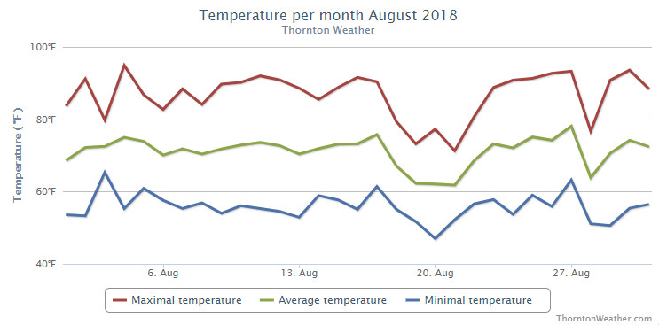
Somewhat of a mixed bag for Thornton’s weather in August. While we enjoyed temperatures near normal without too many extremes, precipitation was lacking considerably from what we expect during the month.
The month started out toward the cool side but with days of above normal temps interspersed. For the first few weeks it appeared we would end up a good bit cooler than normal but then the heat returned for much of the last week driving up average temperatures.
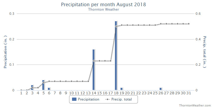
Precipitation was quite disappointing with only a couple decent rainfalls during the month and a few minimal events.
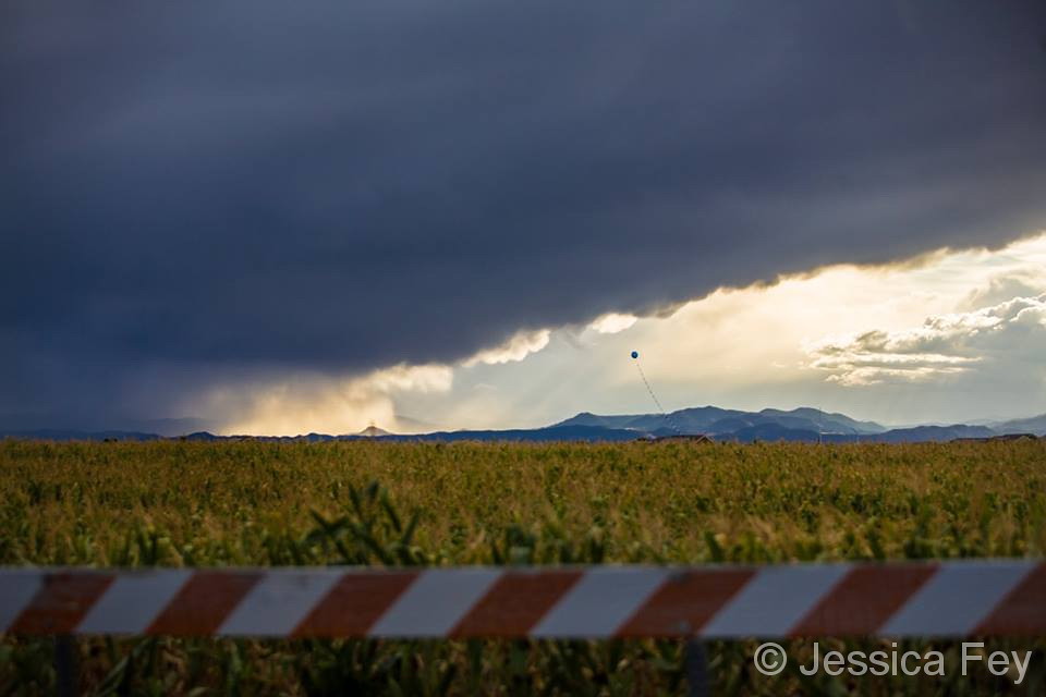
Probably the most notable thing for the month was the relatively persistent haze from smoke from wildfires to our west. While it made for pretty sunrises and sunsets, it obscured our normally beautiful blue skies.
Thornton finished the month with an average temperature of 70.4 degrees. That is more than two degrees cooler than Denver’s long term August average of 72.5 degrees. As is the norm, Denver’s official measurement came in a good bit warmer with an average of 72.4 degrees.
Our highs ranged from a maximum of 94.9 degrees on the 4th of the month down to a low of 47 degrees on the morning of the 20th. Denver matched our maximum on the same date and saw a low of 46 degrees on the 20th which also tied the record low for the date.
The month saw a paltry 0.52 inches fall in Thornton’s rain bucket. Denver actually fared better with 0.93 inches. Both measurements however fell short of the August average of 1.69 inches.
Thornton, Colorado’s August 2018 temperature summary. (ThorntonWeather.com)Thornton, Colorado’s August 2018 precipitation summary. (ThorntonWeather.com)
CLIMATE REPORT
NATIONAL WEATHER SERVICE DENVER/BOULDER CO
318 PM MDT SAT SEP 1 2018

...................................

...THE DENVER CO CLIMATE SUMMARY FOR THE MONTH OF AUGUST 2018...

CLIMATE NORMAL PERIOD 1981 TO 2010
CLIMATE RECORD PERIOD 1872 TO 2018

WEATHER         OBSERVED          NORMAL  DEPART  LAST YEAR`S
                 VALUE   DATE(S)  VALUE   FROM    VALUE  DATE(S)
                                          NORMAL
................................................................
TEMPERATURE (F)
RECORD
 HIGH             105   08/08/1878
 LOW               40   08/26/1910
                        08/25/1910
                        08/24/1910
                        08/22/1904
HIGHEST            95   08/04       105     -10       95  08/19
LOWEST             46   08/20        40       6       51  08/04
AVG. MAXIMUM     86.8              87.2    -0.4     85.7
AVG. MINIMUM     58.0              57.9     0.1     57.3
MEAN             72.4              72.5    -0.1     71.5
DAYS MAX >= 90     11              11.5    -0.5       10
DAYS MAX <= 32      0               0.0     0.0        0
DAYS MIN <= 32      0               0.0     0.0        0
DAYS MIN <= 0       0               0.0     0.0        0

PRECIPITATION (INCHES)
RECORD
 MAXIMUM         5.85   1979
 MINIMUM         0.02   1924
TOTALS           0.93              1.69   -0.76     1.86
DAILY AVG.       0.03              0.05   -0.02     0.06
DAYS >= .01         7               8.6    -1.6        6
DAYS >= .10         2               4.3    -2.3        4
DAYS >= .50         0               1.2    -1.2        2
DAYS >= 1.00        0               0.3    -0.3        0

GREATEST
 24 HR. TOTAL    0.38   08/14 TO 08/14

SNOWFALL (INCHES)
 TOTAL            0.0
RECORD
 TOTAL            0.0               0.0

DEGREE_DAYS
HEATING TOTAL       9                10      -1        8
 SINCE 7/1          9                16      -7        8
COOLING TOTAL     247               244       3      216
 SINCE 1/1        862               688     174      749

FREEZE DATES
RECORD
 EARLIEST     09/08/1962
 LATEST       06/08/2007
EARLIEST                        10/07
LATEST                          05/05
.................................................................

WIND (MPH)
AVERAGE WIND SPEED              10.3
RESULTANT WIND SPEED/DIRECTION   3/176
HIGHEST WIND SPEED/DIRECTION    41/280    DATE  08/27
HIGHEST GUST SPEED/DIRECTION    60/270    DATE  08/27

SKY COVER
POSSIBLE SUNSHINE (PERCENT)   MM
AVERAGE SKY COVER           0.50
NUMBER OF DAYS FAIR           12
NUMBER OF DAYS PC             17
NUMBER OF DAYS CLOUDY          2

AVERAGE RH (PERCENT)     48

WEATHER CONDITIONS. NUMBER OF DAYS WITH
THUNDERSTORMS             9   MIXED PRECIP           0
HEAVY RAIN                1   MODERATE RAIN          3
LIGHT RAIN               12   FREEZING RAIN          0
LT FREEZING RAIN          0   HAIL                   0
HEAVY SNOW                0   SNOW                   0
LIGHT SNOW                0   FOG W/VIS <=1/4 MILE   2
FOG                       4   HAZE                   8

-  INDICATES NEGATIVE NUMBERS.
R  INDICATES RECORD WAS SET OR TIED.
MM INDICATES DATA IS MISSING.
T  INDICATES TRACE AMOUNT.
Weather, natural disasters & climate news and information.


 Following on an August that saw seasonal temperatures but little precipitation, some are certainly hoping for a bit of the wet stuff in September. The month can bring plenty of rain and even our first snow of the season but more often than not, it is one of the most pleasant along the Colorado Front Range.